
Friday, November 05, 2010
Update on Cyclone Jal ... Slightly moved in North-West direction
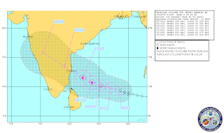
IMD warning, 8:30pm IST
-------------------------------------
cyclonic storm, ‘JAL’ over southeast Bay of Bengal moved northwestwards and lay centered at 1730 hrs IST of today, the 5th November 2010, near lat. 9.50N and long. 87.00E about 600 km east of Trincomalee (Sri Lanka), 800 km east-southeast of Chennai and 1000 km southeast of Visakhapatnam. It would intensify further into a severe cyclonic storm. The system would move west-northwestwards and cross north Tamil Nadu and south Andhra Pradesh coasts between Puducherry and Nellore close to Chennai by 7th November 2010 night.
JTWC warning, 8:30pm IST
----------------------------------------
JTWC tracking
---------------------------

Satellite, IR, 7pm IST
-------------------------------------

-------------------------------------
cyclonic storm, ‘JAL’ over southeast Bay of Bengal moved northwestwards and lay centered at 1730 hrs IST of today, the 5th November 2010, near lat. 9.50N and long. 87.00E about 600 km east of Trincomalee (Sri Lanka), 800 km east-southeast of Chennai and 1000 km southeast of Visakhapatnam. It would intensify further into a severe cyclonic storm. The system would move west-northwestwards and cross north Tamil Nadu and south Andhra Pradesh coasts between Puducherry and Nellore close to Chennai by 7th November 2010 night.
Under its influence, rain/thundershower would occur at most places with isolated heavy to very heavy falls over north coastal Tamil Nadu, Puducherry and south coastal Andhra Pradesh from morning of 6th November 2010. The intensity would increase with heavy to very heavy falls at a few places and isolated extremely heavy falls (≥25 cm) over north Tamil Nadu, Puducherry, south coastal Andhra Pradesh and Rayalaseema from morning of 7th November 2010.
Squally winds speed reaching 55-65 kmph gusting to 75 kmph would commence along and off North Tamil Nadu, Puducherry and south Andhra Pradesh coast from morning of 6th November 2010. It may increase upto 120-130 kmph gusting to 140 kmph at the time of landfall. Sea conditions will be very rough to high, along and off these coasts becoming phenomenal at the time of landfall.
Storm surge of about 1-2 metres above the astronomical tide may inundate the low lying areas of Nellore & Prakasam districts of Andhra pradesh and Tiruvallur, Chennai & kanchipuram districts at the time of landfall.
JTWC warning, 8:30pm IST
----------------------------------------
051500Z POSITION NEAR 9.7N 86.7E.
TROPICAL CYCLONE (TC) 05B (JAL), LOCATED APPROXIMATELY 450 NM
EAST-SOUTHEAST OF CHENNAI, INDIA, HAS TRACKED WEST-NORTHWESTWARD AT
08 KNOTS OVER THE PAST SIX HOURS. THE TC HAS STRUGGLED TO INTENSIFY
UNDER MODERATE EASTERLY SHEAR. JAL IS CURRENTLY ASSESSED AT 45 KNOTS
BASED ON A 3.0/3.0 DVORAK INTENSITY ESTIMATE FROM PGTW. THE UPPER
LEVEL RIDGE AXIS CURRENTLY RUNS ALONG 14.0N, WHICH IS SEVERAL
DEGREES NORTH OF THE TC. JAL WILL APPROACH THE RIDGE AXIS OVER THE
NEXT 2 DAYS AS IT TRANSITS GENERALLY NORTHWESTWARD ALONG THE
SOUTHERN PERIPHERY OF A MID-TO-DEEP LAYER STEERING RIDGE, RELAXING
VERTICAL WIND SHEAR. A MATURE POLEWARD OUTFLOW CHANNEL AND A DEEP
POOL OF WARM WATER IN THE BAY OF BENGAL WILL ALSO SUPPORT
INTENSIFICATION. THE SYSTEM WILL COME ASHORE NEAR CHENNAI SHORTLY
AFTER TAU 48 AND WILL DISSIPATE OVER INTERIOR INDIA. THIS FORECAST
CLOSELY FOLLOWS THE MODEL CONSENSUS. MAXIMUM SIGNIFICANT WAVE HEIGHT
AT 051200Z IS 12 FEET.
JTWC tracking
---------------------------

Satellite, IR, 7pm IST
-------------------------------------

RT @balajisanjeev: Its raining in Chrompet and Tambaram areas as well... Chennai @weatherofindia http://ping.fm/5U34i (8:33pm)
05112010 / 2011 hrs IST
Outer band entered Chennai and now it started raining in Guindy.
051200Z --- NEAR 9.6N 87.1E
MOVEMENT PAST SIX HOURS 285 DEGREES AT 08 KTS
POSITION ACCURATE TO WITHIN 060 NM
POSITION BASED ON CENTER LOCATED BY SATELLITE
PRESENT WIND DISTRIBUTION:
MAX SUSTAINED WINDS - 045 KT, GUSTS 055 KT
WIND RADII VALID OVER OPEN WATER ONLY
RADIUS OF 034 KT WINDS - 055 NM NORTHEAST QUADRANT
045 NM SOUTHEAST QUADRANT
050 NM SOUTHWEST QUADRANT
060 NM NORTHWEST QUADRANT
REPEAT POSIT: 9.6N 87.1E
FORECASTS: 12 HRS, VALID AT:
060000Z --- 10.1N 85.5E
MAX SUSTAINED WINDS - 050 KT, GUSTS 065 KT
WIND RADII VALID OVER OPEN WATER ONLY
RADIUS OF 034 KT WINDS - 070 NM NORTHEAST QUADRANT
060 NM SOUTHEAST QUADRANT
065 NM SOUTHWEST QUADRANT
075 NM NORTHWEST QUADRANT
VECTOR TO 24 HR POSIT: 290 DEG/ 08 KTS
Update on Cyclone Jal ... Now it's named and Not moving
Position :: 9.6 N , 87.1 E
Wind :: 85 kmph
Pressure :: 989 mb
IMD warning, 5:30pm IST
--------------------------------------
The cyclonic storm, ‘JAL’ over southeast Bay of Bengal remained practically stationary and lay centered at 1430 hrs IST of today, the 5th November 2010, near lat. 9.00N and long. 87.50E about 700 km east of Trincomalee (Sri Lanka), 900 km east-southeast of Chennai and 1100 km southeast of Visakhapatnam. It would intensify further into a severe cyclonic storm. The system would move west-northwestwards and cross north Tamil Nadu and south Andhra Pradesh coasts between Puducherry and Nellore close to Chennai by 7th November 2010 evening/night.
JTWC warning
---------------------------
JTWC tracking
----------------------------

Satellite, IR, 6pm IST
------------------------------------

Wind :: 85 kmph
Pressure :: 989 mb
IMD warning, 5:30pm IST
--------------------------------------
The cyclonic storm, ‘JAL’ over southeast Bay of Bengal remained practically stationary and lay centered at 1430 hrs IST of today, the 5th November 2010, near lat. 9.00N and long. 87.50E about 700 km east of Trincomalee (Sri Lanka), 900 km east-southeast of Chennai and 1100 km southeast of Visakhapatnam. It would intensify further into a severe cyclonic storm. The system would move west-northwestwards and cross north Tamil Nadu and south Andhra Pradesh coasts between Puducherry and Nellore close to Chennai by 7th November 2010 evening/night.
Under its influence, rain/thundershower would occur at most places with isolated heavy to very heavy falls over north coastal Tamil Nadu, Puducherry and south coastal Andhra Pradesh from morning of 6th November 2010. The intensity would increase with heavy to very heavy falls at a few places and isolated extremely heavy falls (≥25 cm) over north Tamil Nadu, Puducherry, south coastal Andhra Pradesh and Rayalaseema from morning of 7th November 2010.
Squally winds speed reaching 55-65 kmph gusting to 75 kmph would commence along and off North Tamil Nadu, Puducherry and south Andhra Pradesh coast from morning of 6th November 2010. It may increase upto 120-130 kmph gusting to 140 kmph at the time of landfall. Sea conditions will be very rough to high, along and off these coasts becoming phenomenal at the time of landfall.
Damage expected:
Extensive damage to thatched roofs and huts. Minor damage to power and communication lines due to uprooting of large avenue trees. Flooding of escape routes.
Action suggested:
Total suspension of fishing operations. Fishermen are advised not to venture into the sea. Coastal hutment dwellers to be moved to safer places. People in affected areas to remain indoors.
The system is under constant surveillance and concerned state Govts. are being informed.
JTWC warning
---------------------------
050900Z POSITION NEAR 9.5N 87.5E.
TROPICAL CYCLONE (TC) 05B (FIVE), LOCATED APPROXIMATELY 500 NM
EAST-SOUTHEAST OF CHENNAI, INDIA, HAS TRACKED WEST-NORTHWESTWARD AT
07 KNOTS OVER THE PAST SIX HOURS. THE CYCLONE HAS MAINTAINED AN
INTENSITY OF 45 KNOTS AS IT CONSOLIDATES UNDER MODERATE VERTICAL
WIND SHEAR. BANDING FEATURES ARE STILL SOMEWHAT FRAGMENTED IN
ENHANCED INFRARED IMAGERY. HOWEVER, CENTRAL CONVECTION CONTINUES TO
BUILD. DVORAK ESTIMATES FROM PGTW HAVE STEADIED AT A 3.0/3.0 OR 45
KNOTS OVER THE PAST FEW FIX CYCLES. THE CURRENT POSITION IS BASED ON
A 050228Z SSMIS MICROWAVE IMAGE AND ANIMATED MULTISPECTRAL SATELLITE
IMAGERY. BOTH PLACE THE LOW LEVEL CIRCULATION CENTER WITHIN THE
EASTERN SEMICIRCLE AS CONVECTION SHEARS WESTWARD. THE SYSTEM IS
TRACKING ALONG THE SOUTHERN PERIPHERY OF A SUBTROPICAL STEERING
RIDGE LOCATED TO THE NORTH OF THE CYCLONE. IT WILL CONTINUE TO TRACK
ALONG THIS RIDGE THROUGHOUT THE FORECAST, MAKING LANDFALL WITH INDIA
AFTER TAU 48, BUT NOT BEFORE STRENGTHENING TO NEAR 75 KNOTS. A
DECREASE IN VERTICAL WIND SHEAR, FAVORABLE UPPER-TROPOSPHERIC
OUTFLOW MECHANISMS, AND A DEEP POOL OF WARM WATER WILL ALL SUPPORT
INTENSIFICATION. AFTER LANDFALL THE SYSTEM WILL RAPIDLY WEAKEN AND
DISSIPATE PRIOR TO EMERGING INTO THE ARABIAN SEA. THIS FORECAST LIES
CLOSE TO THE PREVIOUS FORECAST AND NEAR THE MODEL CONSENSUS, WHICH
IS TRENDING SOUTH OF EARLIER RUNS. MAXIMUM SIGNIFICANT WAVE HEIGHT
AT 050600Z IS 12 FEET.
JTWC tracking
----------------------------

Satellite, IR, 6pm IST
------------------------------------

05 B update [051110/0600 UTC]

05B
TROPICAL STORM 05B 6:00UTC 05November2010
UW-CIMSS Experimental Vertical Shear and TC Intensity Trend Estimates
Current Conditions (from JTWC) :
Latitude : 9:24:56 N
Longitude : 88:08:18 E
Intensity (MSLP) : 991.0 hPa
Max Pot Int (MPI,from Emanuel) : 893.7 hPa
MPI differential (MSLP-MPI) : 97.3 hPa
CIMSS Vertical Shear Magnitude : 8.1 m/s
Direction : 103.6 deg
Outlook for TC Intensification Based on Current
Env. Shear Values and MPI Differential
Forecast Interval : 6hr 12hr 18hr 24hr
F F F F
Legend : VF-Very Favorable F-Favorable N-Neutral
U-Unfavorable VU-Very Unfavorable
-- Mean Intensity Trend (negative indicates TC deepening) --
6hr 12hr 18hr 24hr
VF <-3.0mb/ 6hr <-6.0mb/12hr <-9.0mb/18hr <-12.0mb/24hr F -3.0 - -1.5 -6.0 - -3.0 -9.0 - -4.5 -12.0 - -6.0 N -1.5 - +1.5 -3.0 - +3.0 -4.5 - +4.5 -6.0 - +6.0 U +1.5 - +3.0 +3.0 - +6.0 +4.5 - +9.0 +6.0 -+12.0 VU >+3.0 >+6.0 >+9.0 >+12.0
update on S-E Bay Cyclone ... "05B"..Not yet named, getting organized
Satellite shot, 10:30am IST
--------------------------------------

IMD warning, 8:30am IST
---------------------------------------------------
JTWC warning, 8:30am IST
-------------------------------------------------

--------------------------------------

IMD warning, 8:30am IST
---------------------------------------------------
Yesterday’s depression over southeast Bay of Bengal moved west-northwestwards and concentrated into deep depression and lay centred at 0530 hrs IST of today the 5th November 2010 near lat. 9.00N and long. 88.50E about 800 km east of Trincomalee (Sri Lanka), 1000 km east-southeast of Chennai and 1150 km southeast of Visakhapatanam. It would intensify further into a cyclonic storm and move west-northwestwards and cross north Tamil Nadu and south Andhra Pradesh coast between Puducherry and Nellore close to Chennai by 7thNovember 2010 evening/night.
Under its influence, rain/thundershower would occur at most places with isolated heavy to very heavy falls over north Tamil Nadu and south Andhra Pradesh coasts from forenoon of 6th November 2010. The intensity would increase with heavy to very heavy falls at a few places over the above regions from morning of 7th November 2010.
Squally winds speed reaching 55-65 kmph gusting to 75 kmph would commence along and off North Tamil Nadu and south Andhra Pradesh coast from morning of 6th November 2010. Sea conditions will be very rough along and off these coasts from the same time. Fishermen out at sea are advised to return to the coast.
JTWC warning, 8:30am IST
-------------------------------------------------
050300Z POSITION NEAR 9.3N 88.6E.
TROPICAL CYCLONE (TC) 05B (FIVE), LOCATED APPROXIMATELY 530 NM
EAST-SOUTHEAST OF CHENNAI, INDIA, HAS TRACKED WEST-NORTHWESTWARD AT
08 KNOTS OVER THE PAST SIX HOURS. ANIMATED MULTISPECTRAL SATELLITE
IMAGERY AND A 042316Z SSMI IMAGE DEPICT IMPROVED CONVECTIVE BANDING
WRAPPING FROM THE NORTH INTO THE WESTERN QUADRANT. IMAGERY ALSO
SHOWS A PARTIALLY-EXPOSED LOW-LEVEL CIRCULATION CENTER ALONG THE
EASTERN EDGE OF THE CONVECTION, BUT, IN GENERAL, SHOWS A MORE
CONSOLIDATED SYSTEM. ANIMATED WATER VAPOR IMAGERY CONTINUES TO
INDICATE IMPROVING OVERALL OUTFLOW AND SLIGHT IMPROVEMENT OVER THE
EASTERN QUADRANT DESPITE MODERATE EASTERLY VERTICAL WIND SHEAR
(VWS). THE CURRENT INTENSITY IS BASED ON DVORAK ESTIMATES OF 45
KNOTS FROM PGTW. TC 05B IS TRACKING WESTWARD ALONG THE SOUTHERN
PERIPHERY OF THE LOW- TO MID-LEVEL SUBTROPICAL RIDGE AND IS FORECAST
TO CONTINUE TRACKING WESTWARD TO WEST-NORTHWESTWARD THROUGH THE
FORECAST PERIOD. AVAILABLE MODEL GUIDANCE IS IN TIGHT AGREEMENT,
THEREFORE, THIS FORECAST IS POSITIONED CLOSE TO THE MODEL CONSENSUS.
TC 05B IS FORECAST TO INTENSIFY AT A SLOW RATE (TO 55 KNOTS) IN THE
NEXT 24 HOURS DUE TO THE VWS, BUT IS EXPECTED TO INTENSIFY AT
A FASTER RATE AFTER TAU 24 AS VWS DECREASES. THE SYSTEM SHOULD
REACH A PEAK INTENSITY NEAR 75 KNOTS NEAR TAU 48, AND IS EXPECTED TO
DISSIPATE OVER LAND BETWEEN TAU 72-96. MAXIMUM SIGNIFICANT WAVE
HEIGHT AT 050000Z IS 11 FEET.
JTWC tracking
---------------------

CYCLONE JAL UPDATE
Rajesh,Ponniyan,Rakesh, Kaneyan, SSET and all other members to the blog
Wish u a Happy Diwali…..
CYCLONE JAL IS OUR DIWALI GIFT TO EVERYONE IN TN. LET IT JUST RAIN HEAVILY AND CAUSE LESS DAMAGE
CYCLONE JAL UPDATE
——————————–
Time – 07.30am IST
Location – 9.36 N 88.34 E
Pressure – 985.4mb
Intensity – 53.0kt
JTWC - Track
------------
GFS,UKMET,CMC,NOGAPS - Track
---------------------------

Wish u a Happy Diwali…..
CYCLONE JAL IS OUR DIWALI GIFT TO EVERYONE IN TN. LET IT JUST RAIN HEAVILY AND CAUSE LESS DAMAGE
CYCLONE JAL UPDATE
——————————–
Time – 07.30am IST
Location – 9.36 N 88.34 E
Pressure – 985.4mb
Intensity – 53.0kt
JTWC - Track
------------

GFS,UKMET,CMC,NOGAPS - Track
---------------------------

update on S-E Bay Cyclone ... Tropical Cyclone now Not yet named as cyclone jal ... http://ow.ly/34LnL
RT @balajisanjeev: http://ping.fm/X3jCh - Clear sky over pallavaram, pammal areas of Chennai. Evidently no clouds and no sign of rain.
update on S-E Bay Cyclone ... Tropical Cyclone now Not yet named as cyclone jal
Tropical Cyclone now Not yet named as cyclone jal
It's now a numbered system "Tropical Cyclone 05 B"
Position :: 9.3 N , 88.6 E at 5:30 am IST
Wind :: 85 kmph
Pressure :: 989 mb
JTWC warning
---------------------------
JTWC tracking
-------------------------

IMD warning, 2:30am IST
-----------------------------------------
Satellite shot, 5:30am - visible
-----------------------------------------------

Satellite shot, 6am IST - IR
-------------------------------------------

NOGAPS model projection :: Landfall on 7-Nov over N. Tamilnadu coast
------------------------------------------------------------------------------------------------------

It's now a numbered system "Tropical Cyclone 05 B"
Position :: 9.3 N , 88.6 E at 5:30 am IST
Wind :: 85 kmph
Pressure :: 989 mb
JTWC warning
---------------------------
TROPICAL CYCLONE (TC) 05B (FIVE), LOCATED APPROXIMATELY 565 NM
EAST-SOUTHEAST OF CHENNAI, INDIA, HAS TRACKED WESTWARD AT 11
KNOTS OVER THE PAST SIX HOURS. ANIMATED INFRARED SATELLITE
IMAGERY DEPICTS IMPROVED DEEP CONVECTIVE BANDING AND OVERALL
CONSOLIDATION OVER THE PAST 12 HOURS. A 041520Z METOP-A IMAGE
AS WELL AS AN EARLIER 041344Z SSMIS IMAGE DEPICTED A MORE DEFINED
LOW-LEVEL CIRCULATION CENTER (LLCC) WITH MULTIPLE CONVECTIVE
BANDS WRAPPING INTO THE CENTER. THE SSMIS WIND PRODUCT ALSO
SUPPORTED 35 KNOT WINDS WITHIN THE CONVECTIVE BANDING.
ANIMATED WATER VAPOR IMAGERY INDICATES IMPROVING POLEWARD
OUTFLOW AND GOOD OVERALL OUTFLOW EXCEPT FOR THE EAST QUADRANT
DUE TO MODERATE EASTERLY VERTICAL WIND SHEAR (VWS). THE CURRENT
INTENSITY IS BASED ON DVORAK ESTIMATES OF 35 KNOTS FROM PGTW
AND KNES, AND THE SSMIS WIND DATA. TC 05B IS TRACKING
WESTWARD ALONG THE SOUTHERN PERIPHERY OF THE LOW- TO MID-LEVEL
SUBTROPICAL RIDGE AND IS FORECAST TO CONTINUE TRACKING
WESTWARD TO WEST-NORTHWESTWARD THROUGH THE FORECAST PERIOD.
AVAILABLE MODEL GUIDANCE IS IN TIGHT AGREEMENT, THEREFORE, THIS
FORECAST IS POSITIONED CLOSE TO THE MODEL CONSENSUS. TC 05B
IS FORECAST TO INTENSIFY AT A SLOW RATE (TO 45 KNOTS) IN THE
NEXT 24 HOURS DUE TO THE VWS, BUT IS EXPECTED TO INTENSIFY AT
A FASTER RATE AFTER TAU 24 AS VWS DECREASES. THE SYSTEM SHOULD
REACH A PEAK INTENSITY NEAR
65 KNOTS PRIOR TO LANDFALL, AND IS EXPECTED TO DISSIPATE OVER
LAND BY TAU 96.
JTWC tracking
-------------------------

IMD warning, 2:30am IST
-----------------------------------------
The depression over southeast Bay of Bengal moved westwards and lay centred at 2330 hrs IST of 4th November 2010 near lat. 8.50N and long. 89.50E about 900 km east of Trincomalee (Sri Lanka), 1200 km east-southeast of Chennai and 1300 km southeast of Visakhapatanam. It would intensify gradually into a cyclonic storm and move west-northwestwards and cross north Tamil Nadu and south Andhra Pradesh coast between Chennai and Ongole by 7th November 2010 evening/night.
Under its influence, rain/thundershower would occur at most places with isolated heavy to very heavy falls over north Tamil Nadu and south Andhra Pradesh coasts from morning of 6th November 2010. The intensity would increase with heavy to very heavy falls at a few places over the above regions from morning of 7th November 2010.
Squally winds speed reaching 55-65 kmph gusting to 75 kmph would commence along and off North Tamil Nadu and south Andhra Pradesh coast from morning of 6th November 2010. Sea conditions will be rough to very rough along and off these coasts from the same time. Fishermen out at sea are advised to return to the coast.
Squally winds speed reaching 40-50 kmph gusting to 60 kmph would also occur along and off Andaman and Nicobar islands during next 12 hours. Sea condition will be rough to very rough along and off Andaman & Nicobar Islands during next 12 hours. Fishermen are advised not to venture into the sea along and off Andaman and Nicobar islands during next 12 hours.
Satellite shot, 5:30am - visible
-----------------------------------------------

Satellite shot, 6am IST - IR
-------------------------------------------

NOGAPS model projection :: Landfall on 7-Nov over N. Tamilnadu coast
------------------------------------------------------------------------------------------------------

05112010-[deepavalai] JAL watch

NORTH INDIAN OCEAN AREA (MALAY PENINSULA WEST TO COAST OF AFRICA):
A. TROPICAL CYCLONE SUMMARY:
(1) AT 041800Z, TROPICAL CYCLONE 05B (FIVE / [JAL]) WAS LOCATED NEAR 9.0N 88.9E, APPROXIMATELY 565 NM EAST-SOUTHEAST OF CHENNAI, INDIA, AND HAD TRACKED WESTWARD AT 11 KNOTS OVER THE PAST SIX HOURS.MAXIMUM SUSTAINED SURFACE WINDS WERE ESTIMATED AT 35 KNOTS GUSTING TO 45 KNOTS.
1) THE CLOUD TOP TEMEPERATURE NEAR THE CONVERGENT ZONE IS [-]80O C i.e CONVECTIVE CLOUD OF HEIGHT UPTO 16.0KM.
2) THE UPPER LEVEL DIVERGENCE IS PRONOUNCED BOTH ON THE NORTHERN & SOUTHERN SIDES OF THE SYSTEM.THE UPPER LEVEL PRESSURE RIDGE PASSES CLOSER TO 13 DEGREE NORTH. [CHENNAI LATITUDE]
3) WIND CONVERGENT IS ALSO {relatively} PROMINENT ALONG AND ON 10O N AND significantly PRONOUNCED IN LOWER LATITUDES.
4) THERE IS WIND CONVERGENCE IN GULF OF MANNAR
5) THIS IS GOING TO BE A SEVERE ONE.
Subscribe to:
Posts (Atom)