The International Research Institute for Climate and Society (IRI) at the University of Columbia has said that there is a 40 per cent probability of above-normal temperatures breaking out over northwest India during February-March-April.
This is the lowest on a five-grade probable temperature value scale plotted by the IRI in its seasonal weather outlook for this year.
West Rajasthan and adjoining central India could be relatively higher probability (50 to 60 per cent) of above normal temperatures during this period. But elevated probability for above-normal precipitation has been indicated for the North (Jammu and Kashmir, Himachal Pradesh, Uttarkhand, Punjab, Haryana and west Uttar Pradesh) through February to May.
The peninsular south is assessed as having the highest probability (70 per cent) for above normal temperatures during February-March-April.
This region would also have to contend with maximum possibility for below-normal precipitation during this period.
The trend is forecast to continue to hold as such during March-April-May, but probability for linearly regressive temperature values are seen over central India and to the further north.
Rainfall probability for the southwest coast (mainly Kerala) has been indicated to be below normal during this phase.
In what looks like a pleasant surprise, the traditional “hot plates” of Andhra Pradesh and adjoining Orissa may not exactly heat up to those levels during March-April-May and April-May-June.
Rainfall probability has been forecast to be less than normal over coastal Orissa and adjoining coastal areas of Gangetic West Bengal.
As for May-June-July, which coincides with the onset phase of the southwest monsoon, the IRI sees the peninsular south cooling, and the heating anomalies retreating to Gujarat and adjoining west Rajasthan.
ONSET PHASE
Precipitation, too, is seen to be normal for the entire country during the onset phase.
Similar forecast has come from Weather Trends International, a leading US-based private forecaster.
According to Dr Michael Ferrari, a forecast specialist with Weather Trends, initial signals indicate to “a better onset period”.
Last year's onset was delayed, and rains did not really pick up until later in the season.
But for 2010, the private forecaster sees a better start to the season.
“While the onset does look favorable, we are cautious when looking at the rainfall pattern for July through September,” Dr Ferrari wrote in his outlook statement.
“Looking ahead, we are not anticipating a recovery to a normal rainfall distribution for the entire season. Regarding a recovery in the Indian crop as a whole, we are looking towards 2011.”
Scientists with the Research Institute for Global Change in Tokyo have assessed that the prevailing El Nino conditions may have peaked and could give way to a late season La Nina during this year.
They expected precipitation trends through August and September to be likely influenced by the La Nina conditions in the equatorial Pacific that have traditionally favoured the Indian monsoon though without direct cause-effect relationship.
Meanwhile, an update from India Meteorological Department said on Friday that minimum temperatures continued to stay below-normal over many parts of east Uttar Pradesh, central, east and peninsular India and isolated pockets of Punjab. Cold wave conditions prevailed over many parts of Chhattisgarh and some parts of east Uttar Pradesh, east Madhya Pradesh, north interior Karnataka, Punjab, Jharkhand, Gangetic West Bengal, interior Maharashtra and Telangana.
Amritsar recorded the lowest minimum temperature of -1.2 degree Celsius during the 24 hours ending Friday morning.
Forecast for the next two days said that dense fog conditions will continue in the morning hours over parts of Indo-Gangetic plains. Cold wave conditions would occur over parts of central and adjoining east India.
Minimum temperatures may increase over parts of northwest India. Isolated to scattered rain or snow will occur over western Himalayan region. Isolated light rain has also been forecast over Punjab and Haryana mainly on Sunday

Showing posts with label Numeric Forecast India. Show all posts
Showing posts with label Numeric Forecast India. Show all posts
Saturday, January 23, 2010
Sunday, January 03, 2010
Ensemble Forecasting ???
Initially using weather proverbs and today using super computers.
However, modelling the atmosphere and the interconnected oceans is so complicated that we still have a long way to go.
I remember many years ago when I was in Exeter someone said to me "I never watch the weather forecasts because they are always wrong".
I found difficulty seeing how if he never watched how he knew we were always wrong! I had even less chance of persuading him that if we were always wrong, if he always believed the opposite was the correct forecast, he could always be right!
Traditionally, meteorologists collect weather data twenty-four hours a day all around the world, which includes observations from land, sea and in the air. This information is fed very quickly into the super computers, which, by solving a series of mathematical equations, give the meteorologist a variety of weather maps up to a week or so ahead.
The supercomputers provide only one solution to the evolution of the weather patterns.
The supercomputers provide only one solution to the evolution of the weather patterns. This is called a deterministic forecast and gives little idea of the probability of certain events occurring. Scientists, therefore, tried to find a way of giving the meteorologist the probability of the deterministic forecast being correct; they called this an ensemble forecast.
In the atmosphere Chaos Theory reins supreme. It states that if a butterfly flaps its wings in one area of the world, it can have an effect on our weather in the UK. It is probably easier to understand, from the weather point of view, with a different example.
If a raindrop falling onto the top of the Andes in South America encounters a light easterly breeze, it will blow the rain onto the western side of the mountain. It will eventually reach the Pacific Ocean and interact with weather systems there.
If, however, there is a gentle westerly wind the raindrop will fall onto the eastern side and eventually become part of the Atlantic Ocean weather systems.
To cater for this very small change in the initial position of the raindrop above, ensemble forecasts run the deterministic forecast many times using slightly different starting points ending up with many different forecasts for a few days ahead.
While this may seem like a time consuming process, it allows the meteorologist to determine the probability of certain weather events happening.
If the results for most of the forecasts are very similar... the meteorologist has a high degree of confidence in the forecast.
If the results for most of the forecasts are very similar for a certain point in time, then the meteorologist has a high degree of confidence in the forecast. If, on the other hand, the ensemble forecast has a wide scattering of results, then the confidence in a particular forecast is much lower.
In this way the meteorologist can give the listener or viewer a probability of the forecast being correct.
Taken from BBC
However, modelling the atmosphere and the interconnected oceans is so complicated that we still have a long way to go.
I remember many years ago when I was in Exeter someone said to me "I never watch the weather forecasts because they are always wrong".
I found difficulty seeing how if he never watched how he knew we were always wrong! I had even less chance of persuading him that if we were always wrong, if he always believed the opposite was the correct forecast, he could always be right!
Traditionally, meteorologists collect weather data twenty-four hours a day all around the world, which includes observations from land, sea and in the air. This information is fed very quickly into the super computers, which, by solving a series of mathematical equations, give the meteorologist a variety of weather maps up to a week or so ahead.
The supercomputers provide only one solution to the evolution of the weather patterns.
The supercomputers provide only one solution to the evolution of the weather patterns. This is called a deterministic forecast and gives little idea of the probability of certain events occurring. Scientists, therefore, tried to find a way of giving the meteorologist the probability of the deterministic forecast being correct; they called this an ensemble forecast.
In the atmosphere Chaos Theory reins supreme. It states that if a butterfly flaps its wings in one area of the world, it can have an effect on our weather in the UK. It is probably easier to understand, from the weather point of view, with a different example.
If a raindrop falling onto the top of the Andes in South America encounters a light easterly breeze, it will blow the rain onto the western side of the mountain. It will eventually reach the Pacific Ocean and interact with weather systems there.
If, however, there is a gentle westerly wind the raindrop will fall onto the eastern side and eventually become part of the Atlantic Ocean weather systems.
To cater for this very small change in the initial position of the raindrop above, ensemble forecasts run the deterministic forecast many times using slightly different starting points ending up with many different forecasts for a few days ahead.
While this may seem like a time consuming process, it allows the meteorologist to determine the probability of certain weather events happening.
If the results for most of the forecasts are very similar... the meteorologist has a high degree of confidence in the forecast.
If the results for most of the forecasts are very similar for a certain point in time, then the meteorologist has a high degree of confidence in the forecast. If, on the other hand, the ensemble forecast has a wide scattering of results, then the confidence in a particular forecast is much lower.
In this way the meteorologist can give the listener or viewer a probability of the forecast being correct.
Taken from BBC
Friday, November 06, 2009
Moving into a WET phase
MJO suggests that we are movin into a wet MJO phase till 20-Nov-09.
And very DRY from 24-Nov to 15-Dec.
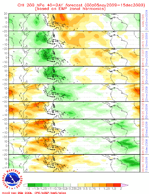
NE monsoon will be active over TN till 20-Nov-09.
This season we might not get the Cyclone over Bay..!!
And very DRY from 24-Nov to 15-Dec.

NE monsoon will be active over TN till 20-Nov-09.
This season we might not get the Cyclone over Bay..!!
Tuesday, November 25, 2008
FNMOC - numeric models
Please check this site for latest FNMOC - WXMAP - Numeric Models
And
EFS PRECIPITATION Probability displays
And
EFS PRECIPITATION Probability displays
Saturday, November 22, 2008
Tuesday, October 28, 2008
2 day Temperature & Percipitation forecast

 These are forecasts of accumulated precipitation and temperature extremes for the next two days (0 - 48hrs).
Friday, December 21, 2007
Tuesday, October 23, 2007
Numeric forecast for 25-Oct updated

Still we can see a LOW forming over the bay of bengal.
Below is the rainfall forecast for 25-Oct.

Sunday, October 21, 2007
Numerical forecast for 25-oct

This forecast is for 25-oct-2007.
You can see a LOW formation over the south-east bay of bengal... will it form or ???
Subscribe to:
Posts (Atom)