Thursday, August 20, 2009
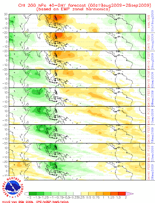
MJO - Moving into a SUPER wet phase
Almost entire India is moving into a very wet MJO phase.
This wet phase starts from 25-Aug and will peak from 3-Sep to 18-Sep... This wet phase will be more severe over southern peninsula.
Hope this brings widespread RAIN all over India.

Half of India affected by drought
Nearly half of India's districts have been hit by drought that could affect the production of rice, the country's farm minister has said.
Sharad Pawar said 246 districts in 10 states had been declared as drought affected. India has some 600 districts.
Separately, authorities in southern Andhra Pradesh state say they are probing whether the suicides of 20 farmers are linked to the drought.
This monsoon season has brought 29% less rainfall than normal.
Rice production in the country could decline by 10 million tonnes this year because of the drought, Mr Pawar said.
India produced nearly 100 million tonnes of rice during 2008-2009, according to official figures.
"Due to the expected reduced production of rice, there could be pressure on availability and market price," he added.
'In-depth probe'
With food prices rising, Mr Pawar said the government was planning to release wheat and rice from its stocks in the open market to keep prices in check.
Leading economist and member in charge of food at India's Planning Commission Abhijit Sen told a newspaper that he did not "foresee a situation where we need to import food".
Separately, the government in Andhra Pradesh has announced an investigation into the suicides of 20 farmers in a little over a month.
The opposition parties have said the farmers were taking their lives because of the drought.
Chief minister YS Rajashekhara Reddy said officials were "conducting an in-depth probe into all the suicides by farmers to establish the reason".
Monsoon rains are critical to India's farm prospects, which account for a sixth of its economic output.
Up to 70% of Indians are dependent on farm incomes, and about 60% of India's farms depend on rains. Irrigation networks are dismissed by critics as inadequate.
The summer rains are crucial to crops such as rice, soybean, sugarcane and cotton.
Source:: BBC
Arabian Sea warms up ahead of reviving monsoon
India Met Department (IMD) has forecast the possibility of isolated heavy rainfall over west coast during the next two days ahead of an organised revival of monsoon over the west coast.
An upper air cyclonic circulation was seen hovering above Lakshadweep islands and adjoining southeast Arabian Sea. South Konkan, Goa, Kerala, coastal Karnataka and Lakshadweep are bracing to witness a spurt in rains.
MJO ASSISTANCE
The Climate Prediction Centre (CPC) of the US National Weather Services sees increased chances of above normal rainfall for the equatorial central Indian Ocean (around Sri Lanka) and southern India during August 18-24.
This is being attributed to the passage of an eastward-bound and periodical Madden Julian Oscillation (MJO) wave featuring enhanced convection in the upper levels of the atmosphere.
The lower levels too are expected to resonate in kind, setting up the required conditions on ground to sustain a rainfall regime that will move north along the coast before spreading east over central India.
The active monsoon phase may last until the month-end, the CPC said. The Wheeler model tracking MJO movement ventured to suggest that the monsoon would be active up to September 6.
But two others - the Jones model and the Empirical Wave Propagation technique employed by the CPC - saw the proceedings wearing off by the month-end. A suppressed convective phase (dry weather) of the MJO will have moved in over equatorial Indian Ocean by then.
HEAVY RAINS
The International Research Institute (IRI) for Climate and Society at Columbia University saw wetter than normal conditions over madhya Maharashtra and south interior Karnataka during August 19-24.
Towards the north, it saw a belt of unusually heavy rains moving west from Bihar and sub-Himalayan West Bengal towards the northern part of central India and even up to west Rajasthan.
In fact, the Noida-based National Centre for Medium Range Weather Forecasting sees an upper air cyclonic circulation shaping up over east Uttar Pradesh by August 22 (Saturday), which will stay active until Tuesday next.
This will bring rains over Uttar Pradesh, and according to the IRI forecasts, could move west taking the rains along.
An IMD update said that monsoon has been active in Assam, Meghalaya, sub-Himalayan West Bengal, Sikkim, east Uttar Pradesh and Punjab during the 24 hours ending Wednesday morning.
The causative upper air cyclonic circulation over northwest Uttar Pradesh and adjoining Uttarakhand has not shown any sign of weakening.
It will continue to bring fairly widespread rainfall over north Uttar Pradesh and Uttarakhand during the next two days with isolated heavy fall during next 24 hours.
