Sunday, March 29, 2009

Chaitén Volcano - John Seach

John Seach was the first scientist to climb to the summit of Chaiten volcano after the May 2008 eruption.
John made two expeditions to Chaiten volcano in 2008

Chaitén volcano is located in southern Chile, 10 km NE of the town of Chaitén on the Gulf of Corcovado. The volcano contains an obsidian lava dome in a 3.5 km wide caldera. The volcano is occasionally covered with snow, but does not contain a glacier. Two small lakes occupy the caldera floor on the west and north sides of the lava dome.

chaiten
John Seach climbing to the summit of Chaiten volcano August 2008.
Warning - Climbing Chaiten volcano is currently dangerous and should not be attempted.

chaiten volcano
John Seach at Chaitén town in July 2008

chaiten
School damaged by lahars in Chaiten town - John Seach

John Seach at Chaiten volcano, 2008.

The volcano erupted on 2nd May 2008. Ash emissions reached a height of 30 km (100,000 ft) on 6th May. More than 4000 people were evacuated fromnearby villages and the town of Chaiten, 10 km from the volcano, and Futaleufu 70 km southeast. This was the first historical eruption at the volcano. The previous dated eruption was over 9000 years ago. The eruption was possibly triggered by tectonic shifts that opened tear faults and promote magma to rise to the surface.

During a visit to Chaitén volcano in Chile on 9th July, John Seach observed lahar destruction of the town, and ashfall damage to surrounding areas, and pyroclastic flow devastation on the north flank of the volcano. On the north side of the volcano at a location 3 km from the crater, an area of devastated forest was visited. Plinian eruptions, and pyroclastic flows, burnt forest and stripped trees of foliage. An area of 10 sq km on the north side of the crater was completely devoid of vegetation, except for some standing devastated trees. Trees up to a meter in diameter were snapped off at a height of 4 m. Fire had burnt the entire area. The field area consisted of a mixture of standing devastated trees, fallen trees, and deep ash deposits. A sharp distinction was observed between areas of devastated forest and standing untouched forest. Continuous ash fall occurred in Chaitén town. Lahars were reaching the town once per week. Residents were allowed into the town to evacuate possessions and begin the clean up. Residents reported hearing rumbling noises under the town, similar to the sound of running water.

In August 2008 John Seach was the first scientist to climb to summit of Chaiten volcano after the May eruption. The summit crater contained a 120 m high lava dome. Earthquakes were felt at the summit. The lava dome was loudly degassing, and lava boulders avalanched from the dome side to the crater floor. John Seach was the first scientist to climb to summit of Chaiten volcano after the worlds largest rhyolite eruption in 100 years.

Taken from www.volcanolive.com

Summer heat on the rise!

Going by satellite images for the past 1 week... it shows a Showery Srilanka and Northern Bay region (Southern West Bengal).

And there was some scattered electric showers around Southern Tamilnadu and along Southern Western Ghats.

No more threat from the Bay for another 1 month.

Only thing is expected, that is PURE Sunshine, Dusty atmosphere and Wind temperature going up.

Chennai:

Still the Wind temperature is bit cool... that's why afternoon's are not that HOT.

Past week's high temperature was around 33 and 34 deg celcius and low was around 25 deg. That's cool compared to that of temperatures this time past month(February).

Max temperature was expected to go beyond 36 deg, but that did not happen.

Humidity was around 65%.

Some towns in southern India is already experiencing 40 deg... this is not good for Summer and if this continues for another month, then we can expect a early south-west monsoon.

Going by the latest GFS... it shows lot of rain activity again along southern most parts of Tamilnadu and along the southern Western ghats. So these regions are expected to get more afternoon electric showers.

Wednesday, March 11, 2009

Nothing for Chennai from "90B"

The "proposed" low pressure system "90B" did not bring anything to Chennai.
While some other parts of Delta region and to areas just south of Chennai received super heavy rains thru past 24hrs.
Here's some rainfall records...
Mayiladuthurai (Nagapattinam dt) recorded extremely heavy rainfall of 37 centimetres.
Talaignayar (Nagapattinam dt) 21, Vedaranyam 19, Tiruvarur and Tirupoondi (Nagapattinam dt) 17 each, Parangipettai 13, Manalmedu (Nagapattinam dt) and Thiruthuraipoondi (Thanjavur dt) 12 each, Nannilam (Tiruvarur dt), Cuddalore and Puducherry Airport 11 each, Chidambaram (Cuddalore dt) 10, Kollidam (Nagapattinam dt), Annamalainagar (Cuddalore dt) and Karaikal 9 each, Sirkali and Tarangambadi (both Nagapattinam dt) and Bhuvanagiri (Cuddalore dt) 8 each and Lalpet (Cuddalore dt) and Kodavasal (Tiruvarur dt) 7 each
These are great record breaking numbers as far as MARCH month is concerned.
Now that the "90B" is out of equation. Latest satellite pic shows, still some remnant along the central coast of Tamilnadu.

And we can see more cloud activity along the 5th parallel, South-east of Srilanka.
We'll keep a watch over the system.
Good news is, we are relieving from the past 3 weeks of un-usual high temperatures.
We'll have a temperature rise starting from tomorrow.

Monday, March 09, 2009

Low pressure system -- 90B

Satellite pic at 17:00 hrs IST.

Yesterdays LOW formations near the south-east of Srilanka over the Southern bay has moved North-west and it's threatening to form into a Well marked LOW or even a Depression in next 24 hrs.
Going by the latest satellite pic, we can see flurry of cloud formations near the North-east of Srilanka over the Bay and near central and North Tamilnadu coast.

Here is the latest warnings issued by JTWC.
*******************************
THE AREA OF CONVECTION PREVIOUSLY LOCATED NEAR 5.7N 83.9E,
IS NOW LOCATED NEAR 6.5N 82.0E, APPROXIMATELY 130 NM EAST OF
COLOMBO, SRI LANKA. ANIMATED ENHANCED WATER VAPOR IMAGERY SHOWS AND
A 082007Z AMSR-E MICROWAVE IMAGE DEPICTS DEEP CONVECTION DEVELOPING
OVER A BROAD REGION OF TURNING CONSOLIDATING INTO A LOW LEVEL
CIRCULATIONS CENTER (LLCC). UPPER LEVEL ANALYSIS INDICATES THE
REGION IS UNDER THE INFLUENCE OF LOW TO MODERATE VERTICAL WIND SHEAR
AND HAS GOOD POLEWARD OUTFLOW. SEA SURFACE TEMPERATURES IN THE AREA
ARE FAVORABLE FOR DEVELOPMENT AS WELL. MAXIMUM SUSTAINED SURFACE
WINDS ARE ESTIMATED AT 20 TO 25 KNOTS. MINIMUM SEA LEVEL PRESSURE IS
ESTIMATED TO BE NEAR 1004 MB. THE POTENTIAL FOR THE DEVELOPMENT OF A
SIGNIFICANT TROPICAL CYCLONE WITHIN THE NEXT 24 HOURS IS UPGRADED TO
FAIR
*******************************
From afternoon of 9-Mar-09, We were hearing some heavy electric showers down south of Tamilnadu and thru Central coastal region of Tamilnadu.
And more heavy rains forecast for Delta region and Southern Tamilnadu. And some for Northern Tamilnadu as well.
Chennai:
It's cloudy and heavy from Morning. Temperature was mild thru the day. No Sunlight.
We had some mild sprinkles of rain.
We'll get some mild showers or strong drizzles late into the Night or early morning tomorrow (10-Mar-09).
Good signs for Rain are, Clouds are getting heavy by evening and wind is from East-south-east for most of the day.
Latest GFS says the system will intensify further and will cross the Delta regions of Tamilnadu.

And pressure maps show "Still a high pressure Anti-cyclone" circulation can be seen over the Northern Bay
AND
"Total percipitable water" over the Southern Bay region has increased dramatically.
This will favor more such LOW formations in coming weeks.
Latest BBC predictions say more rain for Delta region and some for us too.

Friday, March 06, 2009

Formations over Southern Bay


As expected we are following lots of cloud formations over the South Bay, near the 5th parallel and close to South-east of Srilanka.
BBC predictions indicate we might get some showers from this disturbance early next week, But the GFS predicts that the 'LOW' will brush the southern Srilanka and dissipate just south of India over the Ocean.

Chennai:
Still the AIR current is from South-South-East.
This pattern is continuing for the past 2 weeks. Since then the Day temperature & Humidity is on the rise.
Yesterday's high was 35.4°C (11:50am).
We will have a RAIN break soon, within this month end.
It's raining heavy in New-zealand.

Sunday, March 01, 2009

Summer 2009 starts with "Super Heat"

Summer 2009 starts
Chennai:
Many Chennai people wouldn't have witnessed this kind of "Hot & Humid" February.
This kind of Early HEAT was not there for the past 5 to 10 years.
Today (1-Mar-09) it even reached 37.5°C (12:35pm).
Temperature and Humidity rised above normal after 15th of february.
Take a look at the past 5 days plot of Humidity.


Please note "All Time record for March"
High: 40.6 C (29.3.1953)
Low: 16.7 C (19.3.XXXX)
24 Hour Rain: 88.1 mm (5.3.1944)
Total Rain: 262.6 mm (1944)
This year we might witness a NEW high temperature record for the month of March.

Last year we got some rains due to a Cyclone...
What abt RAIN forecast this year this month?? we'll have a look at the latest GFS.

Going by the GFS, we can clearly notice a Anti-cyclone over Andhra-coast and a good Upper air Cyclonic wind circulation near the South-east of Srilanka.
This Cyclonic circulation might trigger a LOW formation in next 5 to 10 days.

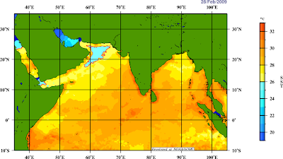
Going by the latest Sea Surface Temperature image... it shows a gradually increase in SST over the whole of Southern Bay and more parts over the South-Arabian Sea.
Still the SST is cold over the northern Bay.
The SST rise over the Southern Bay will favor a LOW formation soon.