
Rains were heavy yesterday (sunday), especially in the Konkan and ghat regions. And the corrected rainfall figures for Mah. in cms:
28 Bhira
22 Karjat, Navsari
20 Matheran
19 Thane
18 Pali, Daman
16 Roha
15 Mahabaleshwar, Bhiwandi, Umargaon
14 Santacruz
13 Kalyan, Ulhasnagar, Mulsi, Jalalpur
12 Khalapur, Mahad, Vapi
11 Talasari, Murbad, Ambarnath, Uran, Panvel, Velhe, Mahudha
10 Vasai, Mangaon, Harij, Madhuban
9 TBI, Sahapur, Vikramgad, Pen, Maval, Radhanpur
Tamini 38, Dawdi 35 , Shirgaon 32 , Dungerwadi 31 , Bhira 28, Ambone23 , Lonavala (T) 20 , Lonavala(O) ,Walvan 17 each, Khopoli 14, Shirota, Bhivpuri 11 each, Khand 10, Thakurwadi, Wangaon 8 each, Koyna(N), Koyna(P) 6 each
Gujarat heavy rainfall figures (Sunday):
Navsari 220 mms, Upleta 214 mms, Umergam 154 mms, Kutiana 150 mms, Bardoli 140 mms, Jamjodhpur 133 mms, Doraji 130 mms,s, Jalapor 127 mms.
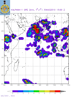
As per the ranfall pattern, in the coastal and ghats region heavy rains were due to
the "activated" off shore trough,embedded with 2 UACs. Rainfall map of Monday shows the rainfed regions.
The incursion of strong moisture laden winds, gave rise to violent thunderstorms in the interiors of the 2 states (Mah. and Guj.).
Now, I anticipate the UAC to move west, towards the Dwarka area of Gujarat,
hence 1 more day of heavy rains of this spell for Gujarat. As the UAC
moves, it should weaken the off shore trough, or in other words "take the steam off" the trough, and bring it back to a "normal'' trough strenght.
For rest of western Mah. region, a decrease in rain from Wednesday, as the moisture level drops due to the vanishing of the UACs.
As yet, I do not foresee any bay low forming till 3rd Sept at least.Possibility on 4th. However, the monsoon axis remains in its normal position.
Due to vanishing of the off shore trough in the east, a sudden decrease in rainfall for the states of T.N./Karnatak and A.P. from Tuesday, till the 3rd.
In fact rains could be very isolated rains in these regions. Chennai can get some convective rains in the afternoon/evening on Tuesday, and clearing up next 3 days.For Bangalore, just some drizzles till 3rd.Sept.
Northern region will also have subdued rains, next 3/4 days.
Sunday/Monday has measured up 200 mms at S'Cruz and 100 mms at Colaba, including 38 mms (Colaba) and 63 mms (S'Cruz) on Monday. Vagaries had estimated average 130 mms for Sunday thru Tuesday.
Lakes supplying Mumbai too had heavy rainfall: Tulsi 21, Vihar 15, Tansa 11,Vaitarna 8, U.Vaitarna 7, Bhatsa 6
From Tuesday, Mumbai rains will decrease, and drop to 15 mms range per day from Wednesday.
Tuesday should guage up about 40 mms of rain in Mumbai,with decrease in intensity towards evening.