Thursday, July 30, 2015

Friday 30th July Post (Night)

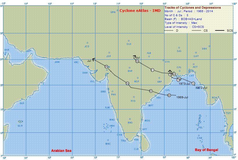
BB-3, now a depression at 992 mb, is positioned in SE Bangladesh. Likely to track W/NW and weaken. Should weaken to 1000 mb by Sunday. 


An new embedded Low in the axis is likely to form in Central India by around 3rd/4th August.


As the erstwhile system in Rajasthan merges with the Monsoon axis, the Western end of the axis rapidly moves Northwards. Due to BB-3, the slope Eastwards of the axis is steep, sloping SE.


Friday 31st and Saturday 1st August..Heavy showers are likely in Kashmir, H.P. and Uttarakhand, Western U.P. and in Western Nepal. 

Rains increasing in both Punjabs on 1st August and continue on Sunday 2nd. 
(Gujrat in Pak Punjab gets increasing precipitation from Saturday. Saturday and Sunday showers will measure around 20 mms per day).

Heavy showers in Chattisgarh. Jharkhand and West Bengal.


Rainfall increasing (due to sectoral strengthening of the off shore trough) in South Konkan and Goa and Coastal Karnataka from Friday and effective thru till Monday.


From Vagaries

Cyclone Komen over N Bay, very near to S-coast Bangladesh


Today, the S Rajasthan circulation has moved N-N-E and weakened over N,N-central Rajasthan.. http://static.ow.ly/photos/normal/c5Ib5.jpg
During past 24hrs, the N Bay LOW has intensified into a Cyclone, now very near to S-S-E Bangladesh coast .. http://static.ow.ly/photos/normal/c5Ids.jpg

Now, the Cyclone is named as Komen, this is expected to be short-lived as it is expected to make landfall by drifting N,N-N-W in 12/18 hrs.

10:30am, One can see the 2 circulations and the clouding around it. Entire N,N-E,N-W,central Bay is very active .. http://static.ow.ly/photos/normal/c5Iin.jpg

RT @ChennaiRains: @Cycloneoi Cyclone in North Ind Ocean after 25 years, July,First since 1989 http://t.co/pP07fXWWk2 http://t.co/D2cfHCdaAZ 

GFS, JTWC expects the Cyclone Komen to move North and make landfall over S coast Bangladesh and move W-N-W to Bengal .. http://static.ow.ly/photos/normal/c5J5I.jpg
11:30am, Komen - ADT analysis ... pressure = 995.3mb, Winds gusting to 70/80 kmph. "No weakening observed".
Landfall in next 6 to 10hrs.

By morning, 1-Aug... remnant of Komen will be over S,central Bengal as Depression.. http://static.ow.ly/photos/normal/c5JiC.jpg
On Saturday, 1-Aug.. the present Rajasthan circulation is expected to drift into central Pakistan and fizzle out .. http://static.ow.ly/photos/normal/c5JA0.jpg
The remnant of Komen is expected to travel West into Jharkhand and then to central Chatisgarh on 2/3-Aug.. http://static.ow.ly/photos/normal/c5JIm.jpg

Rainfall alert for next 36hrs
~~~~~~~~~~~~~~~~~~~~~~~~~~~~~

Before morning of 31-Jul,
Heavy widespread rain for Bengal, Jharkhand, N-coast Odisha and Bihar... http://static.ow.ly/photos/normal/c5K37.jpg

Due to Rajasthan circulation..
Scattered Heavy rain will be over W,central, N,E Rajasthan in next 18hrs.
During next 24hrs, coastal Maharastra is expected to get scattered moderate / heavy rain including Mumbai.

For S Karnataka, #Bangalore, N,N-E Tamilnadu, S,central coast Andhra, #Chennai moderate / light rain possible after 6pm today.

On 31-Jul, as Komen drifts West into Bengal.
Widespread HEAVY rain for N,N-E Odisha, Bengal, Jharkhand, E Uttarpradesh, N,central Chatisgarh
On 31-Jul, Some of heavy rain will also push into E Madhyapradesh as well.
Heavy scattered rain also possible all along Northern zones of Monsoon axis..i.e.. E Bihar, E,central,N Uttarpradesh into Uttarakhand.

Remnant of Rajasthan circulation will continue to pop more rain for N,N-W Rajasthan on 31-Jul.

On 31-Jul, the HEAVY T showers are expected to be back for S,S-E Karnataka, Bangalore, N,N-E Tamilnadu, Chennai, S Andhra. 

Wednesday, July 29, 2015

July 29, 2015 at 12:50PM

Mount Abu, S Rajasthan ..super heavy damaging rains for past 3 days. 26th July.. 444.6mm 27th.. 328mm 28th.. 319.6mm. #iwm

July 29, 2015 at 01:00AM

Chennai - Today and 30-Jul. The present daily heavy T showers will not be there, but scattered moderate/light rain possible after 6pm. #iwm

S Rajasthan depression expected to move North, fizzle in next 42hrs


Latest analysis show that, S Rajasthan circulation, Depression has maintained its intensity and not moved.. http://static.ow.ly/photos/normal/c3V1E.jpg
And same is the case with N Bay LOW / depression as well.
It has slightly intensified and has NOT moved.

11pm, More HEAVY rain seen over S,S-W,S-E Rajasthan, many zones of Gujarat, Odisha, W,S Bengal... http://static.ow.ly/photos/normal/c3Vk4.jpg
11pm, N,N-E,N-central Tamilnadu continues to enjoy T showers for almost 5 continuous days.

There are signs that N Bay low is intensifying fast !
But not expected to drift West or North in next 24hrs.
Next 36hrs, the S Rajasthan Depression is expected to drift N,N-N-E and weaken.
It may fizzle out on Friday morning http://static.ow.ly/photos/normal/c3VHx.jpg

As the S Rajasthan Depression is expected to fizzle out on Friday, the N Bay LOW will make a drift North and then West on Friday.
On Friday night, the Bay circulation, LOW is expected to drift West into N-E Odisha, S Bengal .. http://static.ow.ly/photos/normal/c3Wbj.jpg
E,E-central India to get more widespread HEAVY rain from Friday.
The circulation is expected to move West to central Madhyapradesh by 2-Aug 

Rainfall forecast for next 24hrs
~~~~~~~~~~~~~~~~~~~~~~~~~~~~~~~~

Before evening today...
Heavy & Very Heavy rain for N,N-E,E,S Gujarat into S,S-W,S-E,E,central Rajasthan .. http://static.ow.ly/photos/normal/c3XOW.jpg
Today, some heavy rain also expected over N-W,coastal Maharastra, Mumbai and S-E Gujarat.

On Eastern front...
Widespread heavy rain again expected over S,central Bengal, some zones of Jharkhand and N-E Odisha before midnight today

Today evening...
Scattered T showers expected over S Madhyapradesh, S,central chatisgarh, N Maharastra.

Today as well only moderate scattered rain forecast for Karnataka coast.
And
Almost NO or less, scattered rain for Kerala.

July 29, 2015 at 12:04AM

RT @shanpati: @weatherofindia crazy weather in #Mumbai.. 10 min of v heavy rains n gusts.. quiet for some time n then "Repeat" 7:20pm #iwm

Tuesday, July 28, 2015

July 28, 2015 at 07:54PM

A super sunset photo from Dohnavur, s tip Tamilnadu. #weather

from Instagram

July 28, 2015 at 07:16PM

6:25pm, Ahmedabad - after showers till noon, now windy and cloudy again. #weather

from Instagram

July 28, 2015 at 04:03PM

Report -Still raining with gusty winds in N Gujarat. Highways blocked between Deesa and Dhanera. Even in Tharad it has rained heavily. #iwm

SST on Twitter

RT @SanjaySTank: Kutch rain updates @ingujaratinfo @weatherofindia @gujarattourism @InfoGujarat #Rains http://t.co/LVOpK6noaf #iwm
Taken from Weather of India

July 28, 2015 at 03:59PM

Gujarat - Bhuj another 101mm in 6hrs till 2.30pm Ahmedabad 51mm till 2.30pm. #iwm

July 28, 2015 at 03:33PM

A Deep depression over S Rajasthan is causing this. #weather

from Instagram

Monday, July 27, 2015

July 27, 2015 at 03:40PM

Chennai - 3:35pm, lots of mini T cells visible over entire W,NW,SW horizon. Rain expected to push into city in next 1 to 2 hrs. #iwm

What's Really Warming the World?

What's really warming the world?? .. http://ow.ly/3xZkj4 #iwm
Taken from Weather of India

FLOOD alert :: N,central,E,N-W Gujarat, S,S-W,S-E Rajasthan, W Madhyapradesh


During next 2/3 days...
The S Rajasthan LOW is expected to deepen and persist almost in same zone... http://static.ow.ly/photos/normal/c1I0o.jpg
Almost the same situation expected for N Bay LOW..
This LOW is also not expected to move N-W during next 2/3 days... http://static.ow.ly/photos/normal/c1I0o.jpg

GFS expects BOTH the systems to persist in SAME location even till Friday.
This can be a disaster for N,N-W Gujarat, S,S-W,S-E Rajasthan !
GFS expects S Rajasthan LOW to drift W-N-W into Pakistan ONLY on 2-Aug. 
And the N Bay LOW to move West on that day.. http://static.ow.ly/photos/normal/c1InD.jpg

Till Wednesday / Thursday.. the west coast offshore trough will be active from S Gujarat to central Karnataka coast.
Heavy rain ahead !

Rainfall forecast for next 36hrs
~~~~~~~~~~~~~~~~~~~~~~~~~~~~~~

From NOW till noon of 29-Jul..
HEAVY / Very HEAVY rain forecast for N,N-E,central,E,N-W,S,S-W Gujarat ... http://static.ow.ly/photos/normal/c1IBx.jpg
From NOW till noon of 29-Jul..
Very HEAVY rain forecast for S,S-W,S-E,S-central Rajasthan, W,S-W Madhyapradesh ... http://static.ow.ly/photos/normal/c1IBx.jpg

During next 2 days, Heavy rain also for N-W,coastal Maharastra, Mumbai 
and 
Moderate / heavy rain for coastal Karnataka and Goa.

On eastern end of axis..
Scattered heavy rain for Jharkhand, S,central Bengal, N,coast Odisha on today and 28-Jul.

From midnight today and till noon of 29-Jul... Less or NO rain forecast for Kerala !.. http://static.ow.ly/photos/normal/c1IRK.jpg

Aternoon to midnight of Today and 28-Jul..
Scattered T showers for S,S-E Karnataka, Bangalore, N,N-E,N-central Tamilnadu, Chennai, S Andhra.

Over North end of monsoon axis...
Scattered heavy rain expected Himachal, Uttarakhand into S,S-W Kashmir for 48hrs.. http://static.ow.ly/photos/normal/c1J6o.jpg

A perfect start to the week. Twin engine for the Monsoon !


Today, there's twin propellers of Monsoon is in force...
One is over S Rajasthan.
And
Another over N-extreme Bay.. http://static.ow.ly/photos/normal/c1GHm.jpg
West-coast offshore trough seen from S Gujarat to central coast Kerala.
And
East-coast trough from N Bay to S-E coast Tamilnadu.

For both LOWs, circulations from low to upper-levels are strong and located almost in same locations respectively.. http://static.ow.ly/photos/normal/c1HcJ.jpg

11am, HEAVY rain N,N-W,central Gujarat, N-W,N-coast Maharastra, Mumbai.. cloudy with showers over Jharkhand, Bengal http://static.ow.ly/photos/normal/c1Hxz.jpg
11am, Heavy rain seen all along Karnataka and in some zones of central Kerala as well ... http://static.ow.ly/photos/normal/c1Hxz.jpg

RT @malhotramona: @weatherofindia Mumbai rains now http://t.co/pKDkaUJDKq (8:57am)

RT @rdsouza11: Rain likely in #bangalore #monsoon skies r dark..  http://t.co/KjvrhdfKDz (12:19pm)
More rain ahead !! http://static.ow.ly/photos/normal/c1HHb.

Sunday, July 26, 2015

July 26, 2015 at 10:40PM

Chennai - 10:30pm, a heavy T shower with gusts now pushing into W,SW suburbs. #weather

from Instagram

July 26, 2015 at 10:38PM

Today evening, Kodaikanal, heavy rain. #weather

from Instagram

Friday, July 24, 2015

#Chennai - 9:30pm, Today's T shower swept across N-W,N suburbs of city and now its over Sea..


Weather of India http://ift.tt/1HYc3kL

July 24, 2015 at 01:18PM

#Chennai - Yesterday rainfall.. Airport = 17.4 mm Nungambakkam = 14 mm IWM Polichalur = 12 mm (16.2mm on 22-Jul) #iwm

More rain for W-central,central,East India and a WET week ahead

RT @sanjeevnaique: Heavy rain lashes in #Margao in #Goa south coast of India. Normal #Monsoon begins. @naikap (9:30am)

Today, the low,mid-level circulation seen over E,N-E Madhyapradesh and the S-W Gujarat coast circulation persists .. http://static.ow.ly/photos/normal/bZl52.jpg
Good West coast offshore trough seen from S Gujarat to central coast Kerala ... http://static.ow.ly/photos/normal/bZlMy.jpg

11:30am, Heavy rain over Madhyapradesh into S,S-E Rajasthan, W Gujarat, along Karnataka coast ... http://static.ow.ly/photos/normal/bZlTS.jpg

In next 36hrs, the circulation along S-W Gujarat coast is expected to drift West into N,N-W Arabian sea !
On Sunday, 26-Jul... the eastern end of monsoon axis is expected to drop a LOW along S Bangladesh coast, N Bay.. http://static.ow.ly/photos/normal/bZm3s.jpg
This is followed by a strong circulation, LOW along S,S-W Rajasthan and into S Pakistan... http://static.ow.ly/photos/normal/bZm8p.jpg

More importantly !!
GFS expects both these circulation to persist even till 30-Jul with minimal movement !... http://static.ow.ly/photos/normal/bZmdK.jpg

Rainfall alert for next 36hrs
~~~~~~~~~~~~~~~~~~~~~~~~~~~
Before morning, 25-Jul...
Heavy rain along Southern zones of axis..i.e.. many zones of Madhyapradesh, Chatisgarh, Odisha, Bengal, Bihar.
HEAVY rain forecast for E,S,S-E Gujarat, N,N-W,coastal Maharastra, Mumbai before morning of 25-Jul.. http://static.ow.ly/photos/normal/bZmrc.jpg
Towards early morning... HEAVY rain ahead for N,central,coastal Odisha.

For next 2 days, heavy rain to persist for Coast Karnataka and N,central Kerala coast. !

During next 24hrs, some of the HEAVY rain will push into S,central,S-E Rajasthan !

Today evening again...
Scattered T showers for S,S-E Karantaka, Bangalore, N,N-E,N-central Tamilnadu, Chennai and S, central Andhra.
More HEAVY T showers forecast for S Karnataka, Bangalore, N,N-E,N-central Tamilnadu, Chennai and S Andhra on 25-Jul !

On 25-Jul...
Rainfall intensity over Odisha, Chatisgarh, S Bengal to become HEAVY and widespread... http://static.ow.ly/photos/normal/bZmI7.jpg
On 25-Jul, HEAVY and widespread rain to occur over Madhyapradesh, especially over W,N-W,S-W zones.
More rain ahead for S,S-E Rajasthan on 25-Jul as well !
Some of heavy showers will also be over S,E,S-E Gujarat till night of 25-Jul.

Thursday, July 23, 2015

Night rain in Chennai

Today's [23/7/2015:: 2145 hrs IST] rainfall at Chennai played a decisive role.  Thunder clouds developed in NW of Chennai by 1600 hrs and rain was realised in North Chennai.  Later in the evening by 2000 hrs IST clouds developed in southern sub urb and moved in North / NEly direction to give rain with Thunder storm in the southern parts of the city. The winds were from Southerly to SWly direction

again cloud concentration below 13 Deg latitude.
As the SWM wind strength is diminishing light to moderate rain will be experienced in Kerala and TN.

However NCR region ,Haryana, East Rajastan & Parts of MP & Maharastra is to witness moderate to heavy rains.

TheShriram on Twitter

RT @shri611: 18.00hrs IST. RainGods coming with a vengence. Would it pour or fly away?!? #Chennai http://t.co/rHuIVYaAcE #iwm
Taken from Weather of India

July 23, 2015 at 06:42PM

Chennai - 6:30pm, a disintegrated rain system, now pushed into N,NW parts of city, moving SE. #weather

from Instagram

Wednesday, July 22, 2015

July 22, 2015 at 05:07PM

5pm, This is awesomeness! @weatherofIndia #Chennai #Marina #Beach http://t.co/GrsAgXkO6Q . #weather

from Instagram

July 22, 2015 at 05:02PM

Bangalore, Koramangala - 4:57pm, heavy rain with high winds. #weather

from Instagram

July 22, 2015 at 04:48PM

Chennai - 4:45pm, heavy T shower now sweeping city, suburbs. #weather

from Instagram

July 22, 2015 at 04:25PM

Chennai - 4:22pm, a super T shower is sweeping into W,SW suburbs. View from Polichalur. #weather

from Instagram

More Heavy rain ahead for Gujarat, Madhyapradesh and E,E-central India


Today, low-level circulation seen over W,S-W Gujarat coast and N-E,E Maharastra.. http://static.ow.ly/photos/normal/bWN8c.jpg
And good West-coast offshore trough seen from S Gujarat to central Karnataka coast .. http://static.ow.ly/photos/normal/bWNcu.jpg
East-coast offshore trough seen from central Chatisgarh to S-E Tamilnadu coast ... http://static.ow.ly/photos/normal/bWNcu.jpg


11:30am, HEAVY rain along Kerala coast, N-coast,N-W Maharastra, S,S-E Gujarat, Odisha, Bengal... http://static.ow.ly/photos/normal/bWNhi.jpg
RT @manoramaonline: Heavy rain in #Idukki: Collector issues warning | http://t.co/UU2ldT71V1 #kerala http://t.co/97JB4ueyFq

Today at upper-level (500hpa)...
circulation seen over Jharkhand and S,E Gujarat and near Maharastra coast ..  http://static.ow.ly/photos/normal/bWNty.jpg

In next 36hrs, the W,S-W Gujarat circulation is expected to drift West into N Arabian sea ... http://static.ow.ly/photos/normal/bWNxh.jpg

Meanwhile, the Eastern end of monsoon axis is along Jharkhand and expected to pop a circulation on 25-Jul.. http://static.ow.ly/photos/normal/bWND9.jpg
GFS model expects a strong circulation along N Odisha coast and N-N-W Bay on Sunday !
And the remnant of present Gujarat circulation is also expected to persist over N Arabian sea till Sunday as well !
More rain ahead Gujarat.

Rainfall alert for next 36hrs
~~~~~~~~~~~~~~~~~~~~~~~~~~~~~~
Before morning of 23-Jul...
HEAVY widespread rain for Gujarat (many zones), S,S-E Rajasthan, Madhyapradesh, Chatisgarh, Jharkhand.
In next 24hrs... heavy rain also for Bengal, Odisha and into Bihar. Its happening now.. http://static.ow.ly/photos/normal/bWOd9.jpg

Before morning, 23-Jul...
Scattered heavy rain for central,E Maharastra, S,central Chatisgarh, N,central,S Karantaka, Telegana, N-E Andhra.

Today evening, into midnight...
T showers for S Karnataka, Bangalore, N,central,N-E Tamilnadu, Chennai and into S Andhra.

On 23-Jul..
Heavy rain will be along W,S-W,S Gujarat.
And
Over many zones of Madhyapradesh, Chatisgarh, Jharkhand and N,central Bengal.

Today and 23-Jul...
Heavy rain will persist along Maharastra coast, Karnataka coast and Kerala.

Ariyalur Rain

The very heavy rain above 10 Deg parallel i.e along Ariyalur (158.0mm) [11.13 Deg N], Senthuri (51.0 mm) [11.2 Deg N] Aduthurai, Kudavasal etc was mainly due to the dense clouds developed by 15Z [2030 hrs IST]. That is evident from this picture.


Similarly the cloud mass lingering over central India {MP, West UP, Rajastan, Gujarat} gave copious rainfall.

The upper wind map of to day shows diminished strength of SWM.  even though that is the nature, it may give rainfall to west coast and TN again along and off 10-11 Deg parallel.

 The 700 hPa wind also indicates this.


Tuesday, July 21, 2015

Parts of Eastern and Northern Gujarat got the much needed relief as some showers arrived...Daytime rain on Tuesday was highest at Mahuva with 31 mms. Vadodra received 17 mms. Ahmadabad, which has been dry and waiting , got the predicted showers, with 5.7 mms on Tuesday.

Over night, Valsad district got heavy rains...some figures in cms from Valsad and Dadra Haveli: Kaprada (dist Valsad) 17, Madhbun (dist Dadara & Nagar Haveli) 13, Dharampur (dist Valsad) 12, Nanipalson (dist Valsad) 11, Silvassa (dist Dadara & Nagar Haveli) 9, Pardi (dist Valsad) 6, Vapi (dist Valsad) 4.

Wednesday will see moderate rains in Saurashtra,with Western Saurashtra region (Dwarka) getting heavy rains.  Heavy to moderate in Eastern Gujarat. Rains decrease from Thursday in Gujarat.
Next 3 days till Friday (Decreasing from Friday), Surat and Valsad can get frequent showers, some heavy. Rain amounts will be around 30-35 mms for Valsad and 20-25 mms in Surat.

Rains in Coastal and SE Sindh on Wednesday and Thursday. Karachi possibly getting light to medium rains these 2 days with strong west winds.
Thunder showers also likely in Sukkur (Sindh) on Wednesday and Thursday.

The Monsoon axis starts shifting North again from Wednesday. This will increase rainfall in the Northern plains of U.P, Haryana and Delhi from Thursday 23rd. But, as the axis moves North, very heavy rains expected in Uttarakhand on Thursday and Friday.

Delhi NCR will see rainfall increasing from Thursday for another couple of days.
Even Kolkata, can see an increase in rain amounts after Thursday for a couple of days.

From Vagaries.

July 21, 2015 at 06:25PM

Chennai - 6:21pm, moderate rain now over Polichalur zone. More rain ahead. #weather

from Instagram

July 21, 2015 at 06:00PM

5:58pm, Chennai - a moderate shower is pushing towards SW,WSW suburbs. Photo from Polichalur. #weather

from Instagram

July 21, 2015 at 05:37PM

Kolkata at 3:18pm. Photo from http://ift.tt/1RMmQbR .. #weather

from Instagram

July 21, 2015 at 05:32PM

Bangalore - 4:16pm, heavy rain. #weather

from Instagram

ADI PERUKU

 The gradual (past 24 hrs since 06Z of today) decrease in strength of SWM winds in the west, especially in the deep south and then slight increase of strength of SWM winds today [21.07.2015/ 09Z] is indication of LESSER amount of RF in Kerala & Karnataka region which is UNCOMMON for July. 

"ADI PERUKU" is a festival usually celebrated in the upstream and down stream Cauvery districts of Tamilnadu [i.e Dharmapuri, Krishnagiri, Salem, Erode, Namakkal, Karur, Tricy,Thanjavur, Tiruvarur, & Nagapattinam districts of Tamilnadu and Karaikal district of Puducherry] on 18th day of ADI month i.e THIRD AUGUST.  I hope rain guard will be cordial for Tamil Nadu.


July 21, 2015 at 03:18PM

This is Bareilly, Uttarpradesh at 1pm. #weather

from Instagram