This morning, I spoke about an apparent weakening of TC Sidr, which the JTWC had earlier reckoned to be a Category 4 hurricane with 115-knot (210-kmh) highest sustained winds. This latest infrared shot
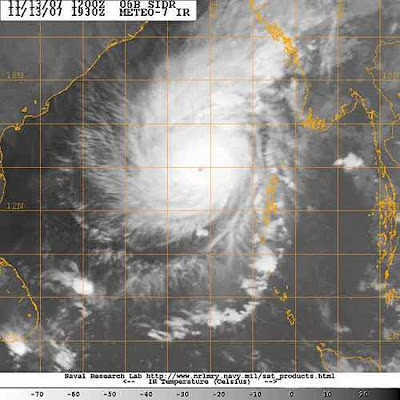
...suggests to me a strengthened (or strengthening) storm with concentric outflow and a well-marked eye. It is a powerful and dangerous tropical cyclone.
The JTWC have not updated since 0600 hours, GMT, Tuesday. The IMD forecast path is here. They have adjusted eastward since I looked at this early in my shift.
Latest numerical forecasts still have disagreement. Actually, I have seen a new NOGAPS, which drives SIdr towards western Bangladesh (Thursday landfall is indicated), and the GFS, which weakens it northwestward to eastern India (landfall is unclear, but seems to be Saturday).
A sub-tropical jet stream is over the northern Subcontinent and so its behavior will bear upon Sidr`s path. A meaningful dip in this stream was shown by the earlier ECMWF to `pick up` Sidr`and send it towards the Bangladesh-Myanmar borderlands. A weaker stream seems to be the cause of the sluggishness seen on the GFS. I am leaning towards the more northerly path, but its no more than a hunch.


