Shifts are happening this week that hint at the start of the North East Monsoon in India. The South West Monsoon, which has been slightly slow in withdrawing, has clung to power in the North East. This has been helped by an upper trough in the sub-tropical jet stream (`western disturbance`) over northern India. Numerical forecasts have been consistent in showing that the upper trough will soon be kicked eastwards leading the westerly flow over the northern Subcontinent to `flatten`. This should boost pressure to the north relative to that over southern India and nearby tropical seas. This would weaken, if not reverse, what remains of the South West Monsoon.
Another factor for flipping the wind flow over India is a tropical depression, or cyclone, that is indicated for the Bay of Bengal on or about the middle of next week. To be sure, this is not a `done deal`, but it has been shown rather consistently for a few days. Anyways, such a low would further bolster the weakening and ultimate reversal of the seasonal wind flow.
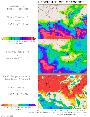
A would-be harbinger of the North East Monsoon, which brings with it the seasonal rains to southeastern India, can be seen on the COLA Website. This is the Short Term Climate Outlook, which is compiled from GFS numerical forecasts. In the second week of the two-week outlook, there is a big blow-up of rainfall over East and South East, India.


