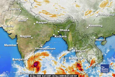
Almost FULL of tamilnadu is wet, yesterday and it's continuing today also.
Here are some rainfall stats::
Parangipettai and Thozhudur (Cuddalore dt) 15 each, Sethiathope, Virudhachalam, Bhuvanagiri and Kuppanatham (all Cuddalore dt), Kallakurichi (Villupuram dt) 13 each, Kothavacherry, Kattumailur and Memathur (all Cuddalore dt) and Kilacheruvai 12 each, Annamalainagar and Vepur (all Cuddalore dt), Lower Anaicut (Thanjavur dt), Manalmedu, Sirkali and Mayiladuthurai (all Nagapattinam dt) and Ramanathapuram 11 each, Chidambaram (Cuddalore dt), Kattumavadi (Pudukottai dt), Pallamorkulam and Rameshwaram (both Ramanathapuram dt) and Ariyalur 10 each, Cuddalore, Pallandurai, Lakkur, Vanamadevi and Lalpet (all Cuddalore dt), Puducherry Airport, Adiramapattinam, Thiruvidaimaruthur (Thanjavur dt), Muthupet and Valangaiman (both Tiruvarur dt), Kollidam (Nagapattinam dt), Mimisal and Viralimalai (both Pudukottai dt) Attur (Salem dt) and Jayamkondam (Perambalur dt) 9 each, Panruti (Cuddalore dt), Thanjavur, Kumbakonam (Thanjavur dt), Manamelkudi, R.S. Mangalam (Ramanathapuram dt), Tondi, Ayikudi (Tirunelveli dt) and Thirumanur (Perambalur dt) 8 each and Kattumannarkoil (Cuddalore dt), Villupuram, Karaikal, Ayyampettai, Manjalaru, Papanasam and Tirukattupalli (all Thanjavur dt), Thiruthuraipoondi (Tiruvarur dt), Ayinkudi, Avudayarkoil and Nagudi (all Pudukottai dt), Thammampatti (Salem dt), Vattanam (Ramanathapuram dt), Kayalpattinam and Maniyatchi (both Tuticorin dt) and Aruppukottai 7 each.
More & more cloud formation can be seen over south-west & south-central Bay.
There are more chances now for a Swirl/Depression near North-East of Srilanka.
Here is the latest numeric prediction...we'll keep updated.

In Chennai:
Yesterday, it was calm thru the day.
Slight drizzles in the evening.
In the early morning (25-Nov-08), we had some sun shine after 3 days.
Now (12:09PM) a high cloud base has moved in from Sea.
Medium low cloud formations can be seen... more likely we'll receive a sharp shower or two in evening.
Also we are experiencing some wind gusts.


