For the Next three days (upto 3rd Dec 2007) we are going to be offline. So sorry folks. See you on 4th Dec.
Till then enjoy the weather!

Friday, November 30, 2007
ICL started
Here is the fixtures!
ICL 20-20 Indian Championship, 2007/08
November 2007
Fri 23 Warm-up - Mumbai Champs v Kolkata Tigers
Western Railway Ground, Mumbai
Sat 24 Warm-up - Chandigarh Lions v Delhi Jets
Teri Oval, Gual Pahari, Gurgaon
Sat 24 Warm-up - Chennai Superstars v Hyderabad Heroes
Vivekananda South India Corporation Agencies Limited College Ground, Chennai
Sat 24 Warm-up - Mumbai Champs v Kolkata Tigers
Western Railway Ground, Mumbai
Sun 25 Warm-up - Chandigarh Lions v Delhi Jets
Teri Oval, Gual Pahari, Gurgaon
Sun 25 Warm-up - Mumbai Champs v Kolkata Tigers
Western Railway Ground, Mumbai
Mon 26 Warm-up - Chandigarh Lions v Delhi Jets
Teri Oval, Gual Pahari, Gurgaon
Mon 26 Warm-up - Chennai Superstars v Hyderabad Heroes
Vivekananda South India Corporation Agencies Limited College Ground, Chennai
Fri 30
18:00 local, 12:30 GMT Chandigarh Lions v Delhi Jets
Tau Devi Lal Cricket Stadium, Panchkula, Chandigarh
December 2007
Sat 1
12:30 local, 07:00 GMT Chennai Superstars v Kolkata Tigers
Tau Devi Lal Cricket Stadium, Panchkula, Chandigarh
Sat 1
18:00 local, 12:30 GMT Mumbai Champs v Hyderabad Heroes
Tau Devi Lal Cricket Stadium, Panchkula, Chandigarh
Sun 2
18:00 local, 12:30 GMT Chandigarh Lions v Kolkata Tigers
Tau Devi Lal Cricket Stadium, Panchkula, Chandigarh
Sun 2
12:30 local, 07:00 GMT Delhi Jets v Hyderabad Heroes
Tau Devi Lal Cricket Stadium, Panchkula, Chandigarh
Mon 3
12:30 local, 07:00 GMT Chennai Superstars v Mumbai Champs
Tau Devi Lal Cricket Stadium, Panchkula, Chandigarh
Wed 5
18:00 local, 12:30 GMT Chandigarh Lions v Hyderabad Heroes
Tau Devi Lal Cricket Stadium, Panchkula, Chandigarh
Fri 7
18:00 local, 12:30 GMT Delhi Jets v Mumbai Champs
Tau Devi Lal Cricket Stadium, Panchkula, Chandigarh
Sat 8
12:30 local, 07:00 GMT Chandigarh Lions v Chennai Superstars
Tau Devi Lal Cricket Stadium, Panchkula, Chandigarh
Sat 8
18:00 local, 12:30 GMT Delhi Jets v Kolkata Tigers
Tau Devi Lal Cricket Stadium, Panchkula, Chandigarh
Sun 9
18:00 local, 12:30 GMT Chandigarh Lions v Mumbai Champs
Tau Devi Lal Cricket Stadium, Panchkula, Chandigarh
Sun 9
12:30 local, 07:00 GMT Chennai Superstars v Hyderabad Heroes
Tau Devi Lal Cricket Stadium, Panchkula, Chandigarh
Mon 10
18:00 local, 12:30 GMT Mumbai Champs v Kolkata Tigers
Tau Devi Lal Cricket Stadium, Panchkula, Chandigarh
Wed 12
12:30 local, 07:00 GMT Chennai Superstars v Delhi Jets
Tau Devi Lal Cricket Stadium, Panchkula, Chandigarh
Wed 12
18:00 local, 12:30 GMT Hyderabad Heroes v Kolkata Tigers
Tau Devi Lal Cricket Stadium, Panchkula, Chandigarh
Fri 14
12:30 local, 07:00 GMT Semi Final 1 - TBC v TBC
Tau Devi Lal Cricket Stadium, Panchkula, Chandigarh
Sat 15
12:30 local, 07:00 GMT 5th Place Play-off - TBC v TBC
Tau Devi Lal Cricket Stadium, Panchkula, Chandigarh
Sat 15
18:00 local, 12:30 GMT Semi Final 2 - TBC v TBC
Tau Devi Lal Cricket Stadium, Panchkula, Chandigarh
Sun 16
12:30 local, 07:00 GMT 3rd Place Play-off - TBC v TBC
Tau Devi Lal Cricket Stadium, Panchkula, Chandigarh
Sun 16
18:00 local, 12:30 GMT Final - TBC v TBC
Tau Devi Lal Cricket Stadium, Panchkula, Chandigarh
Dry again! Cold also
It was slightly dry thru the day, Dry again! is the weather now.
Today's temperature: High 29.4°C @ 1:41pm, Low 20.6°C @ 6:01am.
As you have noticed from our previous post of Global Ocean Temperatures the bay of bengal waters has cooled down, that's why this early onset of winter. So no more humid winds in near future.
Expect cold weather from today to next 3 days.
Here is the overall temperature forecast for next 7 days...


Thursday, November 29, 2007


Japan's Cherry Trees Bloom in Fall; Warming to Blame?
November 27, 2007
Ornamental cherry trees all over the Japanese archipelago have been blossoming unseasonably this fall, according to local media reports.
A few sakura trees—as they are known in Japan—bloom in fall most years.
But with more blossoms appearing earlier this year, there is concern that climate change is affecting a much-loved national symbol of spring.
The popular Somei Yoshino variety of cherry tree produces buds in mid-summer, but a hormone in the leaves causes the buds to hibernate.
When the leaves fall from the tree in spring, the flowers blossom, creating for a few short days a brilliant cloud of white to pale pink blooms.
If the tree loses its leaves prematurely for any reason while the weather is warm, the buds may bloom early—and once they have bloomed, they won't flower again that year.
According to Hiroyuki Wada, chief researcher at the Flower Association of Japan, this year a number of factors have contributed to cherry trees' early leaf loss.
One was an unusually dry, hot summer followed by a severe typhoon that stripped many trees of their leaves.
Another was a warm, late fall that allowed leaf-eating cherry caterpillars and fall webworms to flourish.
With their leaves stripped and the temperatures balmy, many sakura trees were "tricked" into thinking fall was actually spring.
Climate Change Link
Wada believes that climate change could be the root cause of the phenomenon.
"There is probably a connection with global warming," he said.
Typhoons seem to be getting stronger and making landfall more often, he noted, while summer rains are less frequent but heavier.
There are reports that other plants such as azaleas and the Japanese ume plum trees are also blooming off season.
And Wada has heard that Tokyo parks are battling with weeds previously only found in hotter parts of Japan and overseas.
In 2005 the Japan Meteorological Agency issued a report about how rising temperatures are affecting Japanese plants and animals.
The agency found that spring cherry trees are now flowering on average about four days earlier than they did 54 years ago, when record keeping began.
The report also found that Japanese maple leaves are now changing colors 15 days later.But Hiroyuki Uehara, chief of the applied weather information section at the Japan Meteorological Agency, is still cautious about a link between these trends and climate change.
"I think that one possible reason may be global warming, although it is not clear how temperature variations actually affect such phenomena," he said.
"All we can do is provide long-term observation data."
Fragile Icon
Meanwhile, the Japanese people are particularly sensitive to any threat to this cultural icon, Wada said.
In addition to the widespread Somei Yoshino, about 350 varieties of ornamental cherry tree grow in Japan.
The tiny flowers symbolize the fragile transience of life and are featured in everything from J-pop music to pottery to kabuki theater. Viewing parties across the country celebrate their blossoms each spring.
And a famous festival in Washington, D.C., honors Japanese culture around the time that the city's cherry trees—a gift from the people of Tokyo in 1912—come into bloom.
Traditionally, Japan's earliest blossoms appear between January and February on the southern island of Okinawa (see a map of Japan). Tokyo's trees usually open up in late March.
"When I was a student in Tokyo in the early 1980s, sakura bloomed around the first of April," Wada recalled. "Now it is closer to March 20."
He pointed out that the cherry blossom season traditionally coincides with the start of Japan's school and business year, making the flowers a symbol of a fresh new start.
"Sakura was linked to that turning point in people's lives," Wada said. "If the time of the [cherry blossom] season changes, so will Japanese sensibility."
Rising Sea Disrupts Flights in Indonesia
November 27, 2007
Global warming is partly to blame for flooding in Jakarta that has forced thousands of evacuations and cut off a highway to the international airport, Indonesia's environment minister said Tuesday.
Authorities pumped out some of the water, which was 23 feet (7 meters) deep in the worst hit areas and washed more than a mile (1.6 kilometers) inland Monday, said Iskandar, an official at Jakarta's flood crisis center. At least 2,200 houses were inundated, some with chest-deep water.
"I haven't seen it this bad in several years," said Toki, a police officer who was directing traffic around a flooded area near Sukarno-Hatta International Airport, where thousands of passengers were stranded.
Indonesia's environment minister, Rachmat Witoelar, said part of the problem is global warming, which causes sea levels to rise and may make coastal cities like Jakarta especially vulnerable to flooding and monsoon storms.
Authorities also ignored warnings about exceptionally high tides, part of an 18-year cycle, flood expert Jan Japp Brinkman told the Jakarta Post newspaper, adding that the situation was exacerbated by the failure to fix a sea barrier breached more than a week ago.
The flooding came as Indonesia prepared to host next month's UN climate change conference, which aims to start negotiations on a replacement for the 1997 Kyoto Protocol on greenhouse gas emissions.
A sprawling archipelago, Indonesia is among the largest contributors of carbon dioxide emissions, due to its rapid pace of deforestation. Experts say the country is also at risk of becoming one of the biggest victims of global warming.
Wednesday, November 28, 2007
ICL 20-20 matches schedule
ICL Twenty20 League Fixtures
Nov 30: Chandigarh Lions v Delhi Jets
Dec 1: Chennai Superstars v Kolkata Tigers
Dec 1: Mumbai Champs v Hyderabad Heroes
Dec 2: Delhi Jets v Hyderabad Heroes
Dec 2: Chandigarh Lions v Kolkata Tigers
Dec 3: Mumbai Champs v Chennai Superstars
Dec 5: Hyderbad Heroes v Chandigarh Lions
Dec 7: Mumbai Champs v Delhi Jets
Dec 8: Chennai Superstars v Chandigarh Lions
Dec 8: Delhi Jets v Kolkata Tigers
Dec 9: Hyderabad Heroes v Chennai Superstars
Dec 9: Mumbai Champs v Chandigarh Lions
Dec 10: Mumbai Champs v Kolkata Tigers
Dec 12: Chennai Superstars v Delhi Jets
Dec 12: Hyderbad Heroes v Kolkata Tigers
Dec 14: Semi-final I
Dec 15: 5/6 classification; Semi-final II
Dec 16: 3/4 classification; Final
All matches LIVE on Zee sports
After a day of moisture
After a day of relatively high humidity and little rain, today evening it was again DRY and getting cold.
Today's temperatures HIGH 31.0°C @ 11:33am and LOW 23.7°C @ 6:21am.
Satellite pic was a clear picture. So nothing to expect in near future in terms of rain, only the temperature and humidity will come down.
Today's temperatures HIGH 31.0°C @ 11:33am and LOW 23.7°C @ 6:21am.
Satellite pic was a clear picture. So nothing to expect in near future in terms of rain, only the temperature and humidity will come down.
Chennai MRTS

Mass Rapid Transit System is now operating between the Chennai Beach and Velachery from, November 19, 2007.
Tuesday, November 27, 2007

Rain! Rain!
Today was cloudy & mild.
Temperature: High - 28.2°C @ 2:05pm, Low - 23.5°C @ 2:43am
Humidity was on the higher side.
For a surprise it was raining in the evening (6pm). Take a look at the satellite pic nothing there to watch out...

There was signs of North-east warm moist air current from yesterday evening 7PM, It's good to have a spell of rain before dry winter sets in.
Let's hope this spell of showers lasts for another 2 days atleast.
Monday, November 26, 2007
WE NEED BLOGGERS
We need Weather Bloggers from around INDIA and around world.
If you have any article to share please send it to weatherblog@gmail.com
Blog posts can be Images, Articles, Day to day weather, Links and more...
If you have your own blog please send us the LINK we'll show it here for FREE.
Thanks
If you have any article to share please send it to weatherblog@gmail.com
Blog posts can be Images, Articles, Day to day weather, Links and more...
If you have your own blog please send us the LINK we'll show it here for FREE.
Thanks
Cloudy and windy morning
Today the day started as Cloudy, windy and Cold. As you can see the Low temperature 21.4°C was at 7:18am. And today's humidity, high 87% @ 7:36am and low 57% @ 2:36pm, so this means evening is dry and mild.
Take a look at the latest satellite pic.... boo no significant changes.
We might see some changes in weather during the 1st of December, let's wait and see what kind of change? Bursts of rain? very cold? A Depression over bay?

Take a look at the latest satellite pic.... boo no significant changes.
We might see some changes in weather during the 1st of December, let's wait and see what kind of change? Bursts of rain? very cold? A Depression over bay?

Humanity First International - Bangladesh Cyclone
The following facts represent Humanity First International's Current Disaster Assessment of the Bangladesh Cyclone Disaster as produced in coordination with International Relief & Governmental Agencies.
Affected Areas:
The worst affected areas include Bagerhat, Barguna, Barisal, Bhola, Gopalgonj, Jhalkhati, Khulna, Mandaripur, Patuakhali, Pirojpur, Satkhira and Shariatpur districts.
Patuakhali's Golachipa and Mirzaganj and Bagerhat's Shoronkhola and Morolganj upazilas are experiencing the worst drinking water crisis.
Contaminated drinking water has resulted in a diarrhea outbreak which has started to claim lives. The first reports of diarrhea death came from Mathbaria upazila in Pirojpur, where two children died yesterday. NGO workers in a number of worst-hit areas in Patuakhali and Barguna have also reported that hundreds are affected by the disease.
Population Affected:
More than 6 million people in southern districts are now known to have been directly affected by the cyclonic storms.
Missing, Injured, & Death Tolls
2,062 individuals have been reported missing and 6,611 reported injured As of 20 November, the Government of Bangladesh official reports indicated a death toll of 3,447 people.
Property Damage:
An estimated 300,511 homes were destroyed and 626,088 houses were partially damaged. Extensive damage to roads and public buildings also occurred, including 792 educational institutions destroyed with another 4,393 partially damaged.
Crop Damage:
An estimated 870,000 acres of crops were damaged.
Immediate Needs:
- Food
- Clean Water & Water Purification
- Disease Control with focus on Diarrheal Illness Prevention & Treatment
- Shelter Assistance
Long Term Needs:
- Rehabilitation of Industry & Workplaces
- Infrastructure Recovery
- Health and Educational services
- Transition of Short Term to Long Term Housing
For more please visit www.humanityfirst.org
Sunday, November 25, 2007
"Thirparappu" Falls

Thirparappu falls is a natural beauty spot attracts many tourists. It is located at a distance of 25 kms from Nagercoil (Town near Kanyakumari). There is a lord shiva temple. The lord after destroying the yagam of dhaxan as virabhadra murthi has taken abode over here. This lord, who is very sweet for the sincere worshippers, is in a fierce form. This temple is one in the shivalaya ottam temples. There are many old inscriptions in this temple including the one of the pandiya king dated nineth century.
This temple is situated in a very scenic background as the kodhaiyaru rivers makes a fall near the temple. This is a west facing abode. The sanctum is round shaped at the bottom and cone shaped toward the top. There is an abode for jvaradevar in the temple. Beautiful big temple.
Final week forecast for monsoon
If we expect rain from North-East monsoon for Chennai, then we have last 15 days window.
As far as i'm concerned the weather will stay dry thru next week and we might get an odd shower before 10th of December.
All over India the temperature is below normal for this time of the year.
Here's the rainfall forecast for the coming week(s)...

As far as i'm concerned the weather will stay dry thru next week and we might get an odd shower before 10th of December.
All over India the temperature is below normal for this time of the year.
Here's the rainfall forecast for the coming week(s)...

Saturday, November 24, 2007


Shrinking lakes of Siberia ...
The Guardian
Lakes in two large swaths of Siberia are shrinking in size and 125 of them have disappeared altogether, a US study revealed yesterday.
Scientists have examined satellite photographs of 190,000 square miles of Siberia, two areas stretching south between the Ural mountains and the Arctic mining town of Norilsk. They claim the disappearance of the lakes is a consequence of global warming.
The warning comes as Tony Blair flies to Moscow this Sunday to secure the support of Russia's president, Vladimir Putin, for G8 action on climate change.
While there were 10,882 lakes larger than 40 hectares (100 acres) in 1971, there were only 9,712, in 1997 - a decline of 11%.
Published in the journal Science, the study concluded: "The ultimate effect of continued climate warming on high-latitude, permafrost-controlled lakes and wetlands may well be their widespread disappearance."
It said: "Our study reveals a widespread decline in lake abundance and area, despite slight precipitation [rain and snowfall] increases". The study also said the total surface areas of lakes in the region had dropped by 6%, while 125 lakes of this size had disappeared completely.
The study said the way the lake disappearances were spaced out "strongly suggests that thawing of permafrost is driving the observed losses".
It said that in northern areas where there was continuous permafrost - a thick layer of frozen soil that rarely melts during seasonal changes - the total surface area of the lakes grew by 12%. But in the southern regions, the patchy permafrost cover meant that water could drain away, leading to a considerable reduction in lake area.
"These declines have outpaced lake gains in the north, leading to an overall loss to the region," it said.
Russian scientists disagreed that the lake disappearances could be attributed to climate change. Galina Malkova, a senior research fellow of the Moscow-based Earth Cryosphere Institute and an expert on permafrost, said: "The data shows that the increase of temperature did not exceed 0.3C. This is not enough to be considered as a factor.
"The water draining is mainly explained by soil erosion processes," she said, adding that lakes often disappeared as they aged. "Many are gradually taken over by vegetation."
Russia ranks quite low among global polluters. Since its industrial complex began to decline with the collapse of the Soviet Union, emission levels have sunk to levels lower than the projections when it signed up in 1992 to the Kyoto treaty to limit climate change. As it now produces less than its allocated quota of emissions under the treaty, Moscow can sell carbon credits to other treaty signatories.
Russia, the world's number two exporter of oil, ratified the treaty last year, bringing it into legal effect and rescuing it from obsolescence after the US, the biggest polluter, refused to sign up in 2001

Days becoming cold
The days are becoming cold and humidity is getting low... that means winter is setting in.
Clear skys and mild dry wind from North-North-West. Signs of early winter.
You can see for yourself the latest graphs for "Humidity" and "Temperature".


Clear skys and mild dry wind from North-North-West. Signs of early winter.
You can see for yourself the latest graphs for "Humidity" and "Temperature".


Friday, November 23, 2007


Nights becoming cold again
It's getting DRY and cold as days go by.
Chennai has only another 7 days left to complete the 80% quota of average rainfall.
This is a BAD monsoon for us, 80% failed.
Before october from June, we had the wettest period in recorded history, but after that the rainfall rate slowed and got to a STOP now. Very odd North-East monsoon.
Here you can see the data for June to September.
Total: 677 mm
June - 94mm - 174%
July - 249.2mm - 254%
August - 166.2mm - 111%
September - 167.2mm - 154%
It's like from next year we can depend on the South-West monsoon.
Look at the latest satellite pic... bad scene

Astonishing Discovery over the Amazonian Rain Forest

International research team has discovered huge amounts of unexpected organic aerosols over the South-American tropical rain forests
Isoprene, an organic compound generated in large quantities by natural vegetation, was originally thought not to be involved in producing atmospheric aerosols. It has now been found to be a potentially major player in this process. An international team of scientists from the Max Planck Institute of Chemistry, Mainz, Germany, the University of Antwerp, Belgium, the Ghent University, Belgium, and the University of São Paulo, Brazil, examined natural aerosols from the Amazonian rain forest, and has found that they contained two previously unknown compounds, which are photooxidation products of isoprene. These compounds are hygroscopic and could impact cloud formation, rainfall and climate (Science, 20 February 2004).
Isoprene is a volatile organic compound that is emitted in large quantities by forest vegetation. Its annual emission is estimated to be 500 million tons worldwide. But although isoprene readily oxidizes to form volatile products, popular wisdom held that it didn’t form products that could contribute to aerosol particle formation. Intensive measurements over the Amazon Basin, however, revealed the presence of two novel 2?methyltetrol compounds. These compounds are formed in the atmosphere through reaction of isoprene with hydroxyl radicals. To exclude pollution of human origin, the measurements were performed during the rainy season in a remote location of the Amazon Basin. Wind trajectories showed that the air had traveled over several thousand kilometers of pristine tropical forest before being trapped and analyzed.
It is estimated that the photooxidation of isoprene results in an annual production of about 2 million tons of the new compounds. This represents between 5 and 25% of the organic aerosol formed by atmospheric photochemistry from biogenic precursors.
This discovery is a breakthrough because for the first time a link can be demonstrated between isoprene emitted by forest vegetation and formation of water soluble fine particles. These aerosol particles give rise to the formation of haze and reduce the visibility in forested areas. They have an effect on cloud formation and influence rainfall and climate. Original work:
Magda Claeys, Bim Graham, Gyorgy Vas, Wu Wang, Reinhilde Vermeylen, Vlada Pashynska, Jan Cafmeyer, Pascal Guyon, Meinrat O. Andreae, Paulo Artaxo and Willy Maenhaut Formation of Secondary Organic Aerosols Through Photooxidation of Isoprene Science, 303, 1173 (2004), 20 February 2004
Max Planck Society for the Advancement of Science Press and Public Relations Department
Thursday, November 22, 2007
Learn visually from www.accuweather.com
Book mark this link or page. Very useful weather/climate education from accuweather.com. Moreover it's a daily visual dosage of facts and how.

More education, facts and lots coming soon...

More education, facts and lots coming soon...
Partly Cloudy and chances of rain
Here i'm after 24hrs of my previous forecast.
Yesterday it was dry and we had cold winds from North-North-West.
Today the wind direction is slightly from North-East, this should be good for the chances of rain.
Our forecast is we might have light showers in the evening OR night of 22-Nov-2007.
You can see the present conditions in this pic...

Also here is the INFRARED pic of south-asia, you can see(Extreme right of the pic) the 2 T.Cyclones (Hagibis and Mitag) near Philipines. Will the "Hagibis" cross land and come into Bay-of-bengal LIVE? 3 more days for this answer. Previously these kind of systems has crossed into bay and grew again.

Wednesday, November 21, 2007
Traditional weather forecasting - Interesting
Traditional Methods
Wherever humans have settled around the world, being able to predict the weather has been an advantage. Most activities are closely linked to the weather, and communities often have a store of local weather knowledge or lore, often in the form of rhymes and mottos.
A favourite of traditional forecasters, pine cones open and close according to the humidity of the air. An open cone is supposed to mean dry weather and a closed cone indicates damp weather.
Seaweed and other marine algae also respond to changes in humidity. If the humidity is low, it is more likely to be dry the next day - dry seaweed indicates dry weather.
Can poems forecast the weather?
Oak and ash trees are deciduous trees which lose their leaves in winter. In Britain, supposedly if the ash tree has leaves first then it will be a summer of rain; if it is the oak tree first then it will be a fine summer instead. There is a rhyme for this:
Ash leaf before the oak, then we shall have a summer soak; Oak leaf before the ash, the summer comes with nary a splash
Another favourite is the poem:
Red sky at night, shepherd's delight / Red sky in the morning, shepherd's warning
The redness of the sky depends on the amount of dust particles in the air. In Britain, where weather comes from the west, a red sunset suggests that dry weather is approaching.
Such lore is based on years of observation and may sometimes be correct. However, it is likely to be wrong as often as it it right.
Clear sky to start...
At this time(9:03AM) yesterday it was raining heavily, but today at this time it's CLEAR with some thin clouds around. It's like again the North-East has been switched off...mmm
Chennai recorded around 6CM of rain in the past 24hrs.
Here is the latest forecast meteogram for Chennai...

Now here's our forecast for the day, The day will be partly cloudy, mild and high in humidity. Chance of light showers around mid-morning or in the evening.
The rain rate will go down, going by the meteogram.
Tuesday, November 20, 2007

Cyclone Death Toll Up to 3,100 in Bangladesh, May Rise
From National Geographic News.
November 19, 2007
Azahar Ali huddled with his family, reading from the Koran, as the cyclone roared in. First the power went out, then screaming winds blew out the windows and ripped off the roof. Then the sea rushed in, washing him and his family away.
The 80-year-old awoke in a rice paddy to find his son, daughter-in-law, three grandchildren, and three other relatives dead, among the more than 3,100 people killed by Cyclone Sidr.
"I have lost everything," he said Monday while recounting the terror of the worst cyclone in more than a decade to hit this low-lying South Asian nation of 150 million people.
Details of the devastation and the stories of the survivors began to emerge as rescuers reached areas cut off four days earlier when the storm washed out roads and downed telephone lines.
At least 3,113 people were known dead and more than a thousand were missing, said Lt. Col. Main Ullah Chowdhury, a spokesperson for Bangladesh's army.
The Red Crescent Society, the Islamic cousin of the Red Cross, warned that the death toll could rise to 10,000 once rescuers reach outlying islands.
Mike Kiernan, spokesperson for the charity Save the Children, said the final toll could be between 5,000 and 10,000 deaths but added that "we won't know for certain for days or weeks."
He said hundreds of thousands of people managed to escape physical harm, but many lost their homes and crops.
"Just the fact that people were able to survive this does not mean they will survive the second wave of death that comes from catastrophes like this—from lack of clean water, food, basic medicines, and shelter," Kiernan said.
Swept Away
In the village of Parulkhel, residents and rescuers used bamboo poles to probe flooded fields, looking for submerged bodies.
When a woman's corpse was discovered, workers rushed in with sacks and a plastic sheet to lift the body out. Onlookers gathered, and one weeping man identified her as his mother.
"Some were identified and taken away by relatives. We buried dozens of others near where we found them," said Ali Akbar, a volunteer.
Survivors picked through the village's wreckage, looking for anything salvageable in a jumble of splintered wood, bamboo and corrugated iron houses, fallen trees, and bloated animal carcasses. A stench filled the air.
In the neighboring village of Bainsamarta, Sheikh Mubarak, 40, sat among the ruins of his hut weeping for his 12-year-old daughter.
"As our house was washed away by walls of water, I grabbed my daughter and ran for shelter. The monster waves swept her away from me," he said. "Allah should have taken me instead."
Survivors said many of the deaths could have been prevented, but people failed to heed warnings to move to higher ground as the storm approached Thursday.
"Nothing is going to happen—that was our first thought, and we went to bed," said Dhalan Mridha, a 45-year-old farm worker from the village of Galachipa.
"Just before midnight the winds came like hundreds of demons. Our small hut was swept away like a piece of paper, and we all ran for shelter," he said.
On the way, Mridha was separated from his wife, mother, and two children. He found their bodies the next morning, stuck in a battered bush.
Relief Efforts
Government and relief agencies stepped up efforts to get help to devastated areas.
Army helicopters flew in high-protein cookies supplied by the World Food Program, said Emamul Haque, a spokesperson for the UN agency's office in the capital, Dhaka.
International groups promised initial aid totaling $25 million during a meeting with Bangladesh agencies Monday, Haque said.
Tents, water, rice, and other relief items have been slow to reach many.
In the town of Barguna long lines of anxious people formed at the market, hoping for word that help was on the way.
"We have been waiting here for several hours, but no relief," said Uthan Ching, who left clutching an empty plastic bag.
Government officials defended relief efforts and expressed confidence that authorities were up to the task.
"We have enough food and water," said Shahidul Islam, the top official in Bagerhat, a battered district near Barguna. "We are going to overcome the problem."
Aid Money
UN Secretary-General Ban Ki-moon said in a statement that several million dollars were available from the United Nations' emergency response funds, depending on the need.
Many foreign governments and international groups also pledged to help.
The United States offered $2.1 million and two U.S. Marine Corps transport planes arrived in Dhaka with medical supplies, said Chowdhury, the Bangladeshi army spokesman.
A U.S. military medical team was already in Bangladesh and two U.S. Navy ships, each carrying at least 20 helicopters and tons of supplies, would be made available if the Bangladesh government requested them, Secretary of State Condoleezza Rice said in a statement.
The European Union promised $2.2 million and the British government $5.1 million. Italy's Roman Catholic bishops conference said it would donate $2.9 million. The governments of Germany and France each pledged $730,000, Japan sent $318,000 in relief supplies, and the Philippines said it would provide a medical team.
Bangladesh is a densely populated nation sitting on a vast river delta. Storms batter its low-lying lands every year, often killing large numbers of people.
Only two people were killed in Bangladesh by the 2004 Indian Ocean tsunami.
Amazingly heavy rain
Now (8:18 AM) it's raining heavy from 6AM. As if it's like compensating for the last 15 dry days.
Night we had intermittent small showers
I used the word amazing because there's no cloud visible on the latest satellite pic.
Take a look...

Now the monthly rain stands at - 73.4mm (Nov. normal - 350 mm)
Forecast for the day:
Heavy rain will continue till mid-morning and after that there will be drizzles and showers in the evening.
This forecast is based on the latest satellite pic.
Monday, November 19, 2007
Rainy day ahead?
Yesterday night it was raining, Today morning we had light showers and after that it was cloudy thru the day.
Evening at around 5PM rain showers started again.
I think a LOW pressure trough is forming over the coast and the Rain rate might increase from Tonight.
Going by the rapid cloud formation over the coastal tamilnadu...and Bay, it's obvious that the North-East is alive, but for How many days???
Take a look at the latest satellite pic...

Today's Highs and Lows
Temperature: Hi: 29.7°C @ 10:53am ,Low: 22.9°C @ 12:01am
Humidity: Hi: 95% @ 3:21am ,Low: 72% @ 10:50am
Last 24hr rain: 7.8mm
Now take a look at the WIND direction.... for a surprise it shows that predominantly from WEST.

Latest satellite pic from weather.com

You can always follow this LINK to view various SATELLITE pics from weather.com, accuweather.com,IMD and more...
Sunday, November 18, 2007
Good it's raining
After noon today we had 3 or 4 moderate showers. This is very pleasing for Chennai's Northeast monsoon.
I think a low pressure trough might form over west bay along the coast of North-Tamilnadu.
Anyway the NorthEast Monsoon is back Online.
I'm curious to see the day-break tomorrow...
Today's MAX temp 27.6°C @ 10:13am ...cool
I think a low pressure trough might form over west bay along the coast of North-Tamilnadu.
Anyway the NorthEast Monsoon is back Online.
I'm curious to see the day-break tomorrow...
Today's MAX temp 27.6°C @ 10:13am ...cool
Signs of North-East rejunuvation
Today(18-Nov-07) also it was a thinly-cloudy Morning and cold (22°C), but soon after 8 AM RAIN bearing clouds started moving in and drizzled too.
Now(2PM) it's very heavily clouded and chances of light shower is high!
Chennai needs the much needed rain not the Chill.
Here is the latest rainfall record for Nov-2007, 36.6mm (November. normal - 350 mm)
Take a look at some numeric forecast... looks like nothing for us..

Now(2PM) it's very heavily clouded and chances of light shower is high!
Chennai needs the much needed rain not the Chill.
Here is the latest rainfall record for Nov-2007, 36.6mm (November. normal - 350 mm)
Take a look at some numeric forecast... looks like nothing for us..

Chennai - Lowest temperature of the Year
For most of past week, it was DRY and nights were COLD as far as Chennai is concerned.
And interestingly there was no sign of WET north-east wind... this is bad news for Chennai.
Suprisingly, Month and Year low 18.5°C (15/11/07)
17-Nov-2007
Hi: 31.9°C @ 1:23pm Low: 19.5°C @ 5:09am
And interestingly there was no sign of WET north-east wind... this is bad news for Chennai.
Suprisingly, Month and Year low 18.5°C (15/11/07)
17-Nov-2007
Hi: 31.9°C @ 1:23pm Low: 19.5°C @ 5:09am
Saturday, November 17, 2007

Last day for "sidr"? -- see for yourself
Here is "sidr's" LAST path...

-- Reuters (report & video below)
Nov. 16 - Cyclone Sidr triggered a tidal surge on the Bangladeshi coast, devastating three villages. The storm also battered the capital Dhaka.
The death toll has topped 500, and is rising, with thousands injured or missing.
Television news reports said more than 100 fishing boats caught in Cyclone Sidr in the Bay of Bengal had failed to return to shore.
Michelle Carlile-Alkhouri reports.
-- See the latest and last remains of "sidr" (satellite pic) ---
Ha..ha.. nothing visible... that's interesting.

Friday, November 16, 2007
Definition of Sachin Tendulkar??
Tests
1)Tendulkar and Brian Lara are the fastest to score 10,000 runs in Test cricket history. Both of them achieved this in 195 innings.
2)On 3 January 2007 Sachin Tendulkar (5751) edged past Brian Lara's (5736) world record of runs scored in Tests away from home.
3)Career Average 54.95 - the highest average among those who have scored over 10,000 Test runs.
4)Highest number of Test centuries (37).
5)Tendulkar's record of five centuries before he turned 20 is a current world record.
6)Tendulkar has scored centuries against all test playing nations.[48] He was the third batman to achieve the distinction after Steve Waugh and Gary Kirsten. The current list also includes Brian Lara, Ricky Ponting, Rahul Dravid, Jacques Kallis, Adam Gilchrist and Marvan Attapattu.
7)Sachin's 37th ton against Bangladesh during the 2007 series 2nd Test, made historyas the 1st time the top four batsman of any team had all scored centuries in asingle innings. Dinesh Karthik made 129, Wasim Jaffer 138 and Rahul Dravid 129 were the other centurions.
ODIs
1)Most Stadium Appearances: 90 different Grounds.
2)Most Runs: 15,703 Runs at just over 44 runs per innings (as of 5th November 2007),. He is the leading run scorer in the ODI format of the game and the only player ever to cross the 15,000 run mark.
3)First player to reach 10,000-11,000-12,000-13,000-14,000 and 15,000 ODI runs.
4)Holds the record for scoring 1,000 ODI runs in a calendar year. He has done it seven times - 1994, 1996, 1997, 1998, 2000, 2003 and 2007
5)Tendulkar has scored over 1000 ODI runs against all major Cricketing nations.
6)Sachin was the fastest to reach 10,000 runs taking 259 innings and has the highest batting average among batsmen with over 10,000 ODI runs
7)Most centuries: 41
8)Only player to have over 100 innings of 50+ runs (41 Centuries and 85 Fifties)(as of 15th Oct, 2007)
9)Fifties: 85. Tendulkar holds the record for the most ODI fifties,
10)Most centuries vs. Australia, South Africa, New Zealand, Sri Lanka and Zimbabwe.
11)Most Man of the Match Awards: 55 Man of the Match Awards
12)Most Man of the Series Awards: 14 Man of the Series Awards
13)Most ODI runs in a calendar year: 1,894 ODI runs in 1998.
14)Most Centuries in a calendar year: 9 ODI centuries in 1998
15)Sachin Tendulkar with Sourav Ganguly hold the world record for the maximum number of runs scored by the opening partnership. They have put together 6,271 runs in 128 matches that includes 20 century partnerships and 21 fifty run partnerships
16)20 century partnerships for opening pair is also a world record.
17)Sachin Tendulkar and Rahul Dravid hold the world record for the highest
partnership in ODI matches when they scored 331 runs against New Zealand in 1999 at the LBS, Hyderabad[54]
18)Sachin Tendulkar has been involved in six 200 run partnerships in ODI matches - a record that he shares with Sourav Ganguly and Ricky Ponting.
19)Most runs (1,796 at an average of 59.87 as on 20th Mar 2007) in World Cup Cricket History including 4 centuries & 13 fifties with a best score of 152* against Namibia in 2003 world cup.
20)673 runs in 2003 Cricket World Cup, highest by any player in a single Cricket World Cup
21)Tendulkar was the first batsman in history to score over 50 centuries in
international cricket. He has now scored 78 (37 in Tests, 41 in ODIs).
22)Has the most overall runs in cricket, (ODIs+Tests+Twenty20s), as of 30th June 2007 he had accumulated almost 26,000 runs overall.
4th Ind vs Pak one day Highlights -DOWNLOAD

Download the 4th Ind vs Pak one day Highlights
from here
PAK : part1: http://rapidshare.com/files/69895564/4ODI-PakvInd-Pak-Inngs-Part-1.wmv
PAK : part2: http://rapidshare.com/files/69883206/4ODI-PakvInd-Pak-Inngs-Part-2.wmv
IND : part1: http://rapidshare.com/files/69930786/4ODI-PakvInd-Ind-Inngs-Part-1.wmv
IND : part2: http://rapidshare.com/files/70000779/4ODI-PakvInd-Ind-Inngs-Part-2.wmv
Enjoy!
Latest position of weak "sidr"
Here you can view the latest position of "sidr" , fairly weakened.
We are yet to get the full scale damage report of the impact.
As of now "AP" has reported only 2 casualities. More to come later...

We are yet to get the full scale damage report of the impact.
As of now "AP" has reported only 2 casualities. More to come later...

Cyclone batters Bangladesh: REUTERS
DHAKA, Nov 16 (Reuters) - At least nine people died and dozens were missing as a super cyclone packing winds of 250 kph (155 mph) battered vast areas of the Bangladeshi coast overnight, early reports said on Friday.
"The cyclone has caused a havoc in all coastal districts and we will start getting details in few hours," one Satkhira official said.
Hundreds of fishing boats caught in Cyclone Sidr failed to return to shore, and trees and power poles were uprooted disrupting communication and electricity supplies, officials said.
"We have been virtually blacked out all over the country," said a disaster management official in southern Mongla, one of the worst affected areas.
Another official in Mongla said strong winds and heavy rains were still buffeting the area. "We are unable to give a loss estimate immediately."
Television news reports said more than 100 fishing boats in the Bay of Bengal had to failed to return to shore despite repeated storm warnings given over the radio.
"They are missing and we don't know if and when they will come back," said an official in Barguna coastal district.
Five people died in the town of Barisal, including four from one family, after buildings collapsed. Two others died in Bhola and two more in Satkhira districts, local officials said.
Sixteen Bangladeshi fishermen went missing after their fishing boat sank in Cox's Bazar, a resort town some 400 km (250 miles) southeast of Dhaka, a local fishing association said late on Thursday.
Rescued fishermen from Myanmar told Bangladeshi officials that 12 of their compatriots had drowned at sea. They were among a group of fishermen aboard four fishing boats which were smashed into shore by the cyclone, rescuers in Teknaf, a town 500 km (310 miles) southeast of the capital Dhaka, said.
Cyclones can cause immense devastation in disaster-prone Bangladesh, a low-lying country of more than 140 million people. The latest cyclone triggered 5-metre (16 feet) high water surges in many of the affected districts.
It washed away hundreds of thatched homes, destroyed crops and killed livestock.
Storms batter the poor south Asian country every year. A severe cyclone killed more than half a million people in 1970, while one in 1991 killed 143,000 people. (Additional reporting by Reuters stringers in Barisal and Khulna; Editing by David Fox)
Thursday, November 15, 2007
"sidr" - Touch Down
BREAKING NEWS!
Here you can see the "touch-down" of cyclone sidr, over south-east of West-bengal and most of south Bangladesh.
Take a look at this latest satellite pic.

Here you can see the "touch-down" of cyclone sidr, over south-east of West-bengal and most of south Bangladesh.
Take a look at this latest satellite pic.

News report from Cox Bazaar - Bangladesh

Millions of people started leaving homes on the coastlines following Government advice yesterday evening, when the Met Office issued "great danger signal" No 10 for the southwestern Mongla Port and danger signal No 9 in a scale of 10 for the southeastern Chittagong and Cox's Bazar ports as the cylonic storm in the bay was moving fast towards the Bangladesh coast.
Hundreds of thousands of volunteers, aided by the local authorities and Bangladesh Red Crecsent Society, have been helping the people to go to safer places immediately after the Government ordered a massive evacuation.
As per the latest reports recived in the capital at 11:00 last night, the coastal areas were experinecing squally winds accompanied with drizzles from the evening, while panicky people were running for safer places.
Earlier, a senor official of the Ministry of Disaster Management said the deputy commissioners of 16 coastal districts were asked to take necessary steps, including evacuation in line with the previous standing orders for such a situation.Met Office said the cyclonic storm might hit land this morning.
Joint Secretary of Disaster Management Ministry Mohsina Ferdowsi told journalists that a central control room in Dhaka was in constant touch with local administrations in 16 coastal districts and the concerned agencies to monitor the situation while an emergency inter-ministerial meeting was convened for this morning to work out strategies for coordinating rescue and relief efforts.
She said as the Met office at 8:00pm issued the "danger signals" for the three maritime ports as the severe cyclonic storm 'SIDR' with hurricane strong winds at its core roared over the Bay of Bengal and was moving towards the northern shoreline.
An earlier Met office bulletin issued at 6:00pm said the cyclone was packing winds of 165 kilometre per hour (kmph) at its core and was rising to 185 kmph in gusts or squalls. The storm was 755 km southwest of Chittagong, 675km south-south west of Cox's Bazar port and 705 km south of Mongla port. Meteorologists said the cyclone could hit the coastline with full strengthen late today while its "peripheral winds" could brush the coast from midnight last whipping up surges three to five feet above the "normal astronomical tides".
Red Crescent's Cyclone Preparedness Centre Director M Nasirullah said more than 40,000 red crescent volunteers were asked to launch the evacuation drives in the coastline where the number of vulnerable people are nearly 1.20 crore.
"The volunteers are using sirens, loudspeakers and whistles urging people to move out of their homes and move towards safety," including cyclone shelters, Patuakhali correspondent of BSS said by telephone.
Similar reports were received from 13 other coastal districts where the residents and officials said they witnessed gloomy weather featured by drizzles and strong winds while the sea appeared very rough.
Officials in the port city of Chittagong said they already identified the most vulnerable areas in the district, which was experiencing a gloomy weather coupled with drizzles and squally winds since last night.
Reports from the other coastal districts said several hundred fishing boats took shelter in the coast while the authorities ordered temporary suspension of launch or ferry services on internal routes.
But local officials and fishermen's groups said despite the earlier warning signals, several hundred boats were yet to return to the coast since the "sea was not that much rough earlier".
Chittagong, Cox's Bazar and Mongla ports' authorities asked the vessels at its berths to move away as soon as possible after completion of loading and unloading of cargo and suspended further sailing of vessels.
Our Chittagong Correspondent earlier reported that Chittagong Airport was closed and Chittagong Port stopped handling of cargo at outer anchorage of the Bay of Bengal from Wednesday morning.
At least 243 coaster vessels, which were waiting at the port navigation channel, were asked to leave for safer places, the report said quoting a port official.
from www.nation.ittefaq.com
"sidr" latest, tracking and forecast
-- From IMD
The very severe cyclonic storm “SIDR” over eastcentral and adjoining westcentral Bay of Bengal moved further northwards and lay centred at 0830 hours IST of today, the 15th November 2007 over eastcentral and adjoining westcentral and north Bay of Bengal near Lat. 18.00 N and Long 89.00 E, about 530 km south of Kolkata. It is likely to intensify further and move in a northerly direction. The system with maximum sustained wind speed of 200 kmph is likely to cross West Bengal-Bangladesh coast east of Sagar Island near Long. 89.00 E by today around midnight as the system has shown fast movement during past 3 hrs.
Heavy to very heavy falls at a few places and isolated extremely heavy falls (25 cm or more) likely over coastal districts of
West Bengal during next 48 hours causing floods in low lying areas. Gale winds speed reaching 90-120 kmph
are likely to commence by noon of today, the 15th November 2007 and as the system approaches towards the
coast, the gale wind speed reaching180-200 kmph
likely along and off the West Bengal coast.
Storm Surge warning:
Storm surge of height 6-7 metres above normal astronomical tide is likely over
coastal areas of south 24- Parganas and Midnapore districts at the time of landfall.
Sea condition will be phenomenal. Fishermen of the above areas are advised not to venture into the sea.
-- Latest tracking and forecast from JTWC

Cyclone "sidr" is near

Slow moving giant is getting very close to land, it's forecasted to make landfall during the next 36hrs over the border between India(west bengal) and Bangladesh.
Now "sidr" is moving straight North after all that small Zig-Zags.
JTWC have updated their earlier advisory giving the 1200 hrs, GMT, status for this Category 4 hurricane. The eye of Sidr was about 560 miles (900 kms) south of Dhaka, Bangladesh. Highest sustained winds about it were reckoned to be 130 knots, or 240 kmh, which is not far below the threshold to Category 5 hurricane status.
Sidr drifted northward at 7 knots, or 13 kmh.
I cannot overstate that this is a highly dangerous storm posing a major threat wherever it makes landfall. And latest numerical forecasts seem to have narrowed in on the western half of Bangladesh, a shore which is low-lying and riven with many openings and channels. And the western shore of Bangladesh is the forecast landfall of the JTWC. Timing is for sometime between Thursday afternoon and Friday afternoon, local time.
Tidal flooding, far and away the greatest threat to life and limb stemming from SIdr, will hinge upon storm strength at the time of landfall. A Category 4 landfall could be catastrophic, although substantial weaken ahead of landfall seems likely. A Category 1 storm would be serious and damaging, but by orders of magnitude less that of a Category 3 or Category 4 storm.
Here is the latest Infrared pic from JTWC

In my next blog i'll try and post some news analysis from that part of the world.
Wednesday, November 14, 2007
Latest tracking of cyclone "sidr"
Take a look at the latest tracking and forecast of path for the Giant "sidr".
Current position is NEAR 15.0N 89.4E
MAX SUSTAINED WINDS - 120 KT(222.24 KM/hr), GUSTS 145 KT(268.54 KM/hr) ... oh....oh this is massive if this giant makes landfall.
The current forecast of path is towards...South-east West-bengal & South-west of Bangladesh.

Current position is NEAR 15.0N 89.4E
MAX SUSTAINED WINDS - 120 KT(222.24 KM/hr), GUSTS 145 KT(268.54 KM/hr) ... oh....oh this is massive if this giant makes landfall.
The current forecast of path is towards...South-east West-bengal & South-west of Bangladesh.

Local cricket highlights
Take a look at our local cricket. We usually play every Sunday morning at a public Ground in T.nagar,Chennai, India.
It'll be interesting to watch, How crowded the ground is??? I think u'll enjoy it.
More videos and snaps to come later.
It'll be interesting to watch, How crowded the ground is??? I think u'll enjoy it.
More videos and snaps to come later.
"sidr" a Category 4 hurricane
This morning, I spoke about an apparent weakening of TC Sidr, which the JTWC had earlier reckoned to be a Category 4 hurricane with 115-knot (210-kmh) highest sustained winds. This latest infrared shot
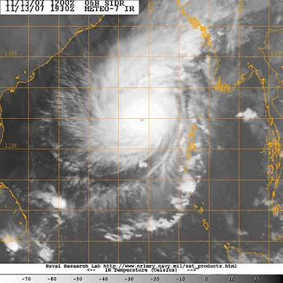
...suggests to me a strengthened (or strengthening) storm with concentric outflow and a well-marked eye. It is a powerful and dangerous tropical cyclone.
The JTWC have not updated since 0600 hours, GMT, Tuesday. The IMD forecast path is here. They have adjusted eastward since I looked at this early in my shift.
Latest numerical forecasts still have disagreement. Actually, I have seen a new NOGAPS, which drives SIdr towards western Bangladesh (Thursday landfall is indicated), and the GFS, which weakens it northwestward to eastern India (landfall is unclear, but seems to be Saturday).
A sub-tropical jet stream is over the northern Subcontinent and so its behavior will bear upon Sidr`s path. A meaningful dip in this stream was shown by the earlier ECMWF to `pick up` Sidr`and send it towards the Bangladesh-Myanmar borderlands. A weaker stream seems to be the cause of the sluggishness seen on the GFS. I am leaning towards the more northerly path, but its no more than a hunch.
Cyclone Advisory - IMD
TROPICAL CYCLONE ADVISORY
RSMC-TROPICAL CYCLONES, NEW DELHI
TROPICAL STORM “SIDR” ADVISORY NO. SIXTEEN ISSUED AT 0200 UTC OF 14TH NOVEMBER, 2007. THE VERY SEVERE CYCLONIC STORM “SIDR” OVER SOUTHEAST AND ADJOINING CENTRAL BAY OF BENGAL MOVED FURTHER NORTHWARD AND LAY CENTRED AT 0000 UTC OF 14TH NOVEMBER 2007 OVER EAST-CENTRAL AND ADJOINING WEST-CENTRAL & SOUTHEAST BAY OF BENGAL NEAR LAT. 14.50 N AND LONG 89.50 E, ABOUT 480 KM NORTHWEST OF PORT BLAIR (43333 ).
ESTIMATED CENTRAL PRESSURE: 964hPa.
THE SATELLITE IMAGERIES SHOW SOLID INTENSE TO VERY INTENSE CONVECTIVE CLOUDS AROUND THE SYSTEM CENTRE.
CURRENT INTENSITY: T5.0 RPT T5.0.
MAXIMUM SUSTAINED SURFACE WIND SPEED IS 90-100 KTS AROUND THE STORM CENTRE.
SEA: PHENOMENAL.
FORECAST: THE STORM IS LIKELY TO MOVE IN A NORTH-NORTHWESTERLY DIRECTION AT ABOUT 08 KT.
INTENSITY T5.5 RPT T5.5 WITH WINDS OF 105 KTS GUSTING TO 125 KTS NEAR THE CENTRE OF THE STORM AT 0000 UTC OF 15TH NOVEMBER 2007.
cyclone "sidr" weakening??
Here i've some numeric forecast for the next 24hrs from WXMAPS suggest "sidr" is going to weaken.
Is this going to happen??? If yes then it's going to be a good news for the people of Orissa, Bengal & Bangladesh.

Another scenario here, the latest satellite pic indicates NO SIGN of letting down.

Is this going to happen??? If yes then it's going to be a good news for the people of Orissa, Bengal & Bangladesh.

Another scenario here, the latest satellite pic indicates NO SIGN of letting down.

Tuesday, November 13, 2007
"sidr" on the move
It has moved north again...
Here is the latest tracking & prediction of it's movement.
It's a slow moving giant.
Watch out people in North-Orissa & South-West Bengal... it's coming.

Here is the latest tracking & prediction of it's movement.
It's a slow moving giant.
Watch out people in North-Orissa & South-West Bengal... it's coming.

India vs Pakistan 3rd one day - Highlights
3rd one day between India and Pakistan highlights download
Part 1: http://www.justupit.com/7ff361b8465f1f661577084326ff6cda
Part 2: http://www.justupit.com/1309e6e89aa71c72af75e0b29b1f3e63
Part 3: http://www.filefactory.com/file/ae60b6
Enjoy the highlights!
Part 1: http://www.justupit.com/7ff361b8465f1f661577084326ff6cda
Part 2: http://www.justupit.com/1309e6e89aa71c72af75e0b29b1f3e63
Part 3: http://www.filefactory.com/file/ae60b6
Enjoy the highlights!
Cyclone "sidr"
Now it has been named "SIDR". A potentially dangerous one.
Tropical Cyclone Sidr seems to have strengthened markedly since the latest (as of this writing) advisory from the JTWC. At that time, highest winds were near 55 knots, or 100 kmh. But have a look at this satellite shot.
We now have an eye, which means that Sidr is almost certainly holds winds of hurricane speed, I believe. As I earlier related, the JTWC had already been forecasting a hurricane-strength storm, so this seems to have come to pass.
Whither from here? While earlier numerical forecasts leaned towards a northerly and northeasterly path of Sidr, Monday`s forecast tracks have shifted westward such that landfall seems to be favored for the northwestern shore of the Bay (Orissa or northern Andhra Pradesh states of eastern India). Timing will be after midweek, maybe Friday-Saturday. Waters of the Bay of Bengal, being near 29 degrees C, are plenty warm to sustain a storm of hurricane intensity for some time to come, so Sidr will need to be followed carefully.
Here we have latest Satellite pic from JTWC

and IMD tracking...

Monday, November 12, 2007
"D" Indeed moving west
Still it's a Depression and in making of a Cyclone, not yet!
Lying centered around south-central bay of bengal.
Still it has lots of chance to move North.
Let's hope it moves west, atleast we might get heavy rains from that system.
It's worth watching this system.
Meanwhile take a look at the latest satellite pic....

Lying centered around south-central bay of bengal.
Still it has lots of chance to move North.
Let's hope it moves west, atleast we might get heavy rains from that system.
It's worth watching this system.
Meanwhile take a look at the latest satellite pic....

D moved a bit to WEST
Going by the latest INFRARED imagery ... the depression over the Bay has moved slightly to the west. Still it's predicted to move North-WEst.
The system is still a Depression and gaining in strength ... may be to a Tropical Cyclone.
We have'nt seen a "Super Cyclone" for the past 3 years.

In Chennai it's quiet DRY, It's unusual for the MID northeast season. The heavy moistured North-East current is OFFLINE. Will it rejunuvate?
The system is still a Depression and gaining in strength ... may be to a Tropical Cyclone.
We have'nt seen a "Super Cyclone" for the past 3 years.

In Chennai it's quiet DRY, It's unusual for the MID northeast season. The heavy moistured North-East current is OFFLINE. Will it rejunuvate?
Subscribe to:
Posts (Atom)