An upper level W.D trough is expected to affect N,N-W India from tomorrow ... http://ow.ly/i/3rsbm

Wednesday, October 16, 2013
Still the factors for onset of NEM is bleak... http://ow.ly/pSphN
A low level circulation is seen over S Bay .. and expected to drift West towards S,S-E Tamilnadu coast.. http://ow.ly/i/3rr22

Low, mid Wind direction along most of Tamilnadu coast, #Chennai and Andhra coast is expected to become N-E from tomorrow morning.
This N-E wind direction and low circulation over S Bay can bring some showers along Tamilnadu coast, #Chennai during next 2 days!
N-E monsoon may set in along N,central Tamilnadu coast and #Chennai on 22-Oct... tentative date !
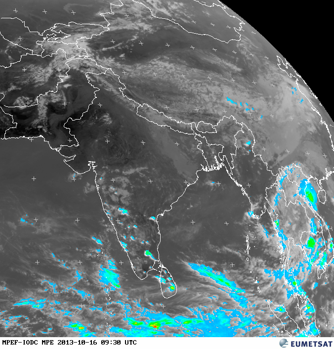
Meanwhile HEAVY rain ahead for S, S,central W-ghats of Kerala and S,W Tamilnadu during next 2 days.
A low level circulation is seen over S Bay .. and expected to drift West towards S,S-E Tamilnadu coast.. http://ow.ly/i/3rr22

Low, mid Wind direction along most of Tamilnadu coast, #Chennai and Andhra coast is expected to become N-E from tomorrow morning.
This N-E wind direction and low circulation over S Bay can bring some showers along Tamilnadu coast, #Chennai during next 2 days!
N-E monsoon may set in along N,central Tamilnadu coast and #Chennai on 22-Oct... tentative date !
Meanwhile HEAVY rain ahead for S, S,central W-ghats of Kerala and S,W Tamilnadu during next 2 days.
RT @kannan2121: @weatherofindia Raining with thunder nd lightning at trivandrum kerala (7:32pm)
8:30pm, HEAVY rain over S,W,N-W Tamilnadu and along S,central, W-ghats Kerala ... http://ow.ly/i/3rpJu
8:30pm, http://ow.ly/i/3rpJu >> rest of #India is Clear !

8:30pm, HEAVY rain over S,W,N-W Tamilnadu and along S,central, W-ghats Kerala ... http://ow.ly/i/3rpJu
8:30pm, http://ow.ly/i/3rpJu >> rest of #India is Clear !

SWM still brings RF

Dharmapuri, Krishnagiri, Erode, Karur, Namakkal, Salem, Perambular, Theni Dindigul, Virudunagar Tirunelveli will be getting rainfall.
Still the factors for onset of NEM is bleak.

RT @rajugana: Bangalore 3.30pm, Partly cloudy skies, it rained in the AN; now its dark n appears more rain likely!! http://t.co/Tw3Hnw6hNk

#Chennai - 4:20pm, cloudy now. Chance of localized shower in next 2 hrs.
Tamilnadu - 4pm, Showers seen near Puducherry zone and over N-central, N Tamilnadu.
#Chennai - 4:20pm, cloudy now. Chance of localized shower in next 2 hrs.
Tamilnadu - 4pm, Showers seen near Puducherry zone and over N-central, N Tamilnadu.
Monsoon withdrawal and remnant of Phailin
Long 2013 SW #Monsoon is expected to withdraw from N,N-W,central India during next 3 days.
Today, a strong Anti-cyclone is persisting over S Rajasthan and expected to persist for another 5 days.. this'll speed up the withdrawal !
The remnant of Cyclone Phailin is still persisting over Bihar ... http://ow.ly/i/3rd4E

Phailin remnant has dumped Heavy rain over E Uttarpradesh, Bihar during past 48hrs.
Phailin dumps rain and misery on UP, Bihar ... http://ow.ly/pREMx
15 killed, power supply snapped in Bihar ... http://ow.ly/pREOG
Seven dead as heavy rains lash Bihar ... http://ow.ly/pRERN
The remnant circulation of Phailin in Low levels is expected to persist even till Saturday !.. http://ow.ly/i/3rdJO
But the rain over E Uttarpradesh, Jharkhand, Bihar and N,central Bengal has subsided and will be even if the circulation persists.
3pm, LESS rain seen over most of India, except over S Peninsula ... http://ow.ly/i/3re3z
16 Oct 2013 / 0300 UTC latest synop
Chennai/ Minambakkam
13-00N| 080-11E| 10m |
03:00
|
AAXX 16034
|
43279 22997 10000 10290 20247 30086 40103 80001 333 10338 20255 59009 6003/ 81075=
|
Bangalore
12-58N| 077-35E| 920m |
03:00
|
AAXX 16034
|
43295 22497 73202 10230 20200 39100 48510 85630 333 10288 20210 56690 59010 6998/ 83710
83612 86358=
|
Thiruvananthapuram
08-29N| 076-57E| 60m |
03:00
|
AAXX
16034
|
43371
22597 13203 10276 20232 30033 40105 81400 333 10330 20232 59011 6990/ 81620=
|
Hyderabad Airport
17-27N| 078-28E| 530m |
03:00
|
AAXX 16034
|
43128 32596 50000 10272 20201 39509 40105 82501 333 10319 20223 59003 82620 83070=
|
||||
| Courtsey :ogimet. |
www.ogimet.com
Subscribe to:
Posts (Atom)