

On the night of 5th and 6th August 2010, between 00:00 hrs and 00:30 hrs, intensive rainfall followed by massive cloudburst in high altitude terrain of Leh (3505m), triggered numerous debris flows, mud flows (earth spreads) and sand flows. These widespread, composite flows in the over saturated slope forming materials caused 182 deaths including that of 3 foreign tourists, damaged 607 houses, breached all major communication networks to Leh town besides inflicting an unaccountable loss of livestock and agriculture fields. The disaster caused severe damage to the settlements in parts of Leh town, Sabu village, Choklamsar, Leh airport area, Nimu, Ney and Bazgo area around the town.
The Deputy Director General, Geological Survey of India, Northern Region, Lucknow nominated S/Sh. VK.Sharma, Sr. Geologist, Ajay Kumar and Pankaj Kumar Geologists to investigate the affected area. The GSI team visited the area from 11th August to 16th August, 2010. Trans Himalayan region, known for its cold and desert type climate owing to scanty rainfall and high sun radiations, had never witnessed such a disastrous scenario since the recorded historical times, notwithstanding the fact that cloudbursts occur frequently in the higher reaches of the mountains.
 The Leh region represents a broad U shaped glacial valley of Indus river sandwiched between the lofty high ranges of Ladakh in the north and Zanskar in the south. Huge piedmont fans, river terraces, recent flood plains with prominent point bars, lateral bars and Aeolian deposits are the major geomorphic units of the terrain. Lacustrine deposits, indicating neotectonic activity, at places, have been observed near Sputik, Phyang and Nimu localities. Geologically, the affected region is occupied by Ladakh Granitoids and Quaternary sediments of glacial, fluvio-glacial, lacustrine, alluvial and Aeolian origins.
Widespread occurrence of varied, unconsolidated Quaternary drift deposits perched over gentle to fairly steep slopes are susceptible to mass movement under conditions of heavy saturation. Unprecedented rainfall of the order of 240 mm within 24 hours on account of cloud bursts in the Leh region during 4-6 August 2010 caused excessive mass movement of drift deposits and over spilling of the banks of the streams. Huge quantities of debris charged water moved in high energy regime destroying everything in its run out path.
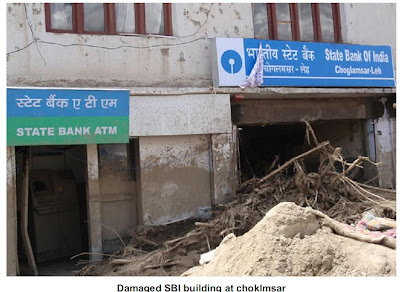 In Leh area, the damage was confined in the catchments of Shaksaling nala, flowing from an elevation 3800 m to 3410 m. The debris flow mobilized and damaged the settlements, Bus Stand building, BSNL buildings, Hospital Complex, Radio Station, etc. in its 3 km run-out distance.The Sabu nala section, located about 11 km east of Leh, was affected the most by the cloudburst. The prolonged and heavy rainfall that reportedly lasted for 30 minutes raised the water level by about 10-15 feet and triggered the movement in slope debris. Water charged with debris, wooden logs and huge blocks of granite choked the course of the nala at bridge points near villages Zong, Myek and Ayu Sabu. The village settlements, forest and agricultural fields were damaged on account of over spilling of water mixed with debris and boulders, which flowed out with an appalling velocity, resulting death of 11 persons in Sabu village. When the debris blockades at bridge points breached due to further on-gush, the debris flow spread out in the downstream commands. This phase, lasting for about 30-45 minutes, was, in fact, the major cause of devastation to Choklamsar village, ITBP Camp, Leh-Manali route, New Choklamsar market, etc. It is reported that bodies of 48 people were recovered from the debris from these areas. A pile of debris upto 4 m high was observed at Leh–Manali road near New Choklamsar village. The debris further moved and spread along the road before falling into Indus river. Typical accumulation lobes of finer fraction of debris material were observed at tail end of the flow.
  The total run out distance of the debris flow from the epicenter of the cloudburst in the Sabu nala to the tip of the debris flow was of the order of 10 km. The maximum lateral spread of debris flow has been observed to be about 2 km. The morphological dimension of the debris flow and lateral spread belies the current figures of deaths and damages in the area. Stokma nala, flowing adjacent to Stokma village, was blocked by huge boulders and wooden logs resulting in diversion of the nala course towards the right bank in a geomorphic depression /dry nala. The Druk Padma Karpo Institute, generally referred to as “Ranchoo’s School”, located within the flow direction of mud/soil/silt has been affected. The surge of mudflow entered the classrooms of the School.
The Deputy Director General, Geological Survey of India, Northern Region, Lucknow nominated S/Sh. VK.Sharma, Sr. Geologist, Ajay Kumar and Pankaj Kumar Geologists to investigate the affected area. The GSI team visited the area from 11th August to 16th August, 2010. Trans Himalayan region, known for its cold and desert type climate owing to scanty rainfall and high sun radiations, had never witnessed such a disastrous scenario since the recorded historical times, notwithstanding the fact that cloudbursts occur frequently in the higher reaches of the mountains.
 The Leh region represents a broad U shaped glacial valley of Indus river sandwiched between the lofty high ranges of Ladakh in the north and Zanskar in the south. Huge piedmont fans, river terraces, recent flood plains with prominent point bars, lateral bars and Aeolian deposits are the major geomorphic units of the terrain. Lacustrine deposits, indicating neotectonic activity, at places, have been observed near Sputik, Phyang and Nimu localities. Geologically, the affected region is occupied by Ladakh Granitoids and Quaternary sediments of glacial, fluvio-glacial, lacustrine, alluvial and Aeolian origins.
Widespread occurrence of varied, unconsolidated Quaternary drift deposits perched over gentle to fairly steep slopes are susceptible to mass movement under conditions of heavy saturation. Unprecedented rainfall of the order of 240 mm within 24 hours on account of cloud bursts in the Leh region during 4-6 August 2010 caused excessive mass movement of drift deposits and over spilling of the banks of the streams. Huge quantities of debris charged water moved in high energy regime destroying everything in its run out path.
 In Leh area, the damage was confined in the catchments of Shaksaling nala, flowing from an elevation 3800 m to 3410 m. The debris flow mobilized and damaged the settlements, Bus Stand building, BSNL buildings, Hospital Complex, Radio Station, etc. in its 3 km run-out distance.The Sabu nala section, located about 11 km east of Leh, was affected the most by the cloudburst. The prolonged and heavy rainfall that reportedly lasted for 30 minutes raised the water level by about 10-15 feet and triggered the movement in slope debris. Water charged with debris, wooden logs and huge blocks of granite choked the course of the nala at bridge points near villages Zong, Myek and Ayu Sabu. The village settlements, forest and agricultural fields were damaged on account of over spilling of water mixed with debris and boulders, which flowed out with an appalling velocity, resulting death of 11 persons in Sabu village. When the debris blockades at bridge points breached due to further on-gush, the debris flow spread out in the downstream commands. This phase, lasting for about 30-45 minutes, was, in fact, the major cause of devastation to Choklamsar village, ITBP Camp, Leh-Manali route, New Choklamsar market, etc. It is reported that bodies of 48 people were recovered from the debris from these areas. A pile of debris upto 4 m high was observed at Leh–Manali road near New Choklamsar village. The debris further moved and spread along the road before falling into Indus river. Typical accumulation lobes of finer fraction of debris material were observed at tail end of the flow.
  The total run out distance of the debris flow from the epicenter of the cloudburst in the Sabu nala to the tip of the debris flow was of the order of 10 km. The maximum lateral spread of debris flow has been observed to be about 2 km. The morphological dimension of the debris flow and lateral spread belies the current figures of deaths and damages in the area. Stokma nala, flowing adjacent to Stokma village, was blocked by huge boulders and wooden logs resulting in diversion of the nala course towards the right bank in a geomorphic depression /dry nala. The Druk Padma Karpo Institute, generally referred to as “Ranchoo’s School”, located within the flow direction of mud/soil/silt has been affected. The surge of mudflow entered the classrooms of the School.
The airfield of the Leh, one of the highest airports in the world, is uniquely situated in a ‘U’ shaped wide valley. The granite hills around the airport area are covered by a pile of piedmont fans, lacustrine deposits and top layer of Aeolian sand. The field area is on the fluvio-glacial deposits. The cloudbursts affected the airfield when sand /Aeolian deposits and a section of terrace spread out over the air strip, thereby hampering the air traffic, and to an extent, the rescue operations.
The natural depressions on both sides of nala and low lying dry streams, where sprawl of settlements have grown, were in general, the worst affected sites of devastation; the higherelevation of slopes were the least affected locations. The mass movement in geologically fragile Quaternary sediments under unprecedented saturated conditions was largely responsible for the devastation. The selection of sites for rehabilitation in the area should, therefore, consider the local geomorphic setting, the nature of slope forming material and potential run-out zones of mass movements.
The natural depressions on both sides of nala and low lying dry streams, where sprawl of settlements have grown, were in general, the worst affected sites of devastation; the higherelevation of slopes were the least affected locations. The mass movement in geologically fragile Quaternary sediments under unprecedented saturated conditions was largely responsible for the devastation. The selection of sites for rehabilitation in the area should, therefore, consider the local geomorphic setting, the nature of slope forming material and potential run-out zones of mass movements.