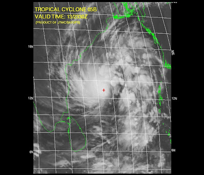
Look at the latest projection by JWTC...


It's destined to HIT South-Andhra. This is happenning after almost 2 years (according to my memory, I'll clarify on this later)
Chennai lies in a least danger zone.
Sky is cloudy and will be cloudy.
Typical sky before a Cyclone.
If the cyclone gathers speed and moves as it is now... then we can expect light showers from Today evening.
Some text from JWTC:
************************************
AT 140000Z TROPICAL STORM (TS) 05B WAS LOCATED NEAR 12.9N
84.8E, APPROXIMATELY 265 NM EAST OF MADRAS, INDIA, AND HAD TRACKED NORTH-
WESTWARD AT 05 KNOTS OVER THE PAST SIX HOURS. MAXIMUM SUSTAINED SURFACE
WINDS WERE ESTIMATED AT 35 KNOTS GUSTING TO 45 KNOTS. SEE REF A (WTIO31
PGTW 140300) FOR FURTHER DETAILS
************************************

Yeah it looks like its going to Andhra. Hopefully we will get some rain. Latest GFS says we might get showers for next 1 week.
ReplyDeleteI read in the Hindu yesterday that we are entering another dry phase of the MJO. It said from 18/11 to 10/12, it will be dry. I hope it is wrong.
wat s dis ther snt any cloud movement(11 am) all models predict hvy rain in chennai although cyclone s expected to hit jst north of us dont we hav radar systems?
ReplyDeleteYes, i agree with "Keaweather", there'll be more rains thru to end of next week.
ReplyDelete"Johnny" pls be patient while the system comes more and more near.. Initially it'll start to drizzle, then heavy steady drizzle and then u'll see HEAVY cloud movements.
Let s see but looking at the latest sat pics 12pm i cant see any swirly cloud its all dispersed and weakening it ll again gain strength evening or ni8 i think, just lik yesterday.
ReplyDelete情色電影, aio交友愛情館, 言情小說, 愛情小說, 色情A片, 情色論壇, 色情影片, 視訊聊天室, 免費視訊聊天, 免費視訊, 視訊美女, 視訊交友, ut聊天室, 視訊聊天, 免費視訊聊天室, a片下載, av片, A漫, av dvd, av成人網, 聊天室, 成人論壇, 本土自拍, 自拍, A片,
ReplyDelete愛情公寓, 情色, 舊情人, 情色貼圖, 情色文學, 情色交友, 色情聊天室, 色情小說, 一葉情貼圖片區, 情色小說, 色情, 色情遊戲, 情色視訊, 情色電影, aio交友愛情館, 色情a片, 一夜情, 辣妹視訊, 視訊聊天室, 免費視訊聊天, 免費視訊, 視訊, 視訊美女, 美女視訊, 視訊交友, 視訊聊天, 免費視訊聊天室, 情人視訊網, 影音視訊聊天室, 視訊交友90739, 成人影片, 成人交友,
免費A片, 本土自拍, AV女優, 美女視訊, 情色交友, 免費AV, 色情網站, 辣妹視訊, 美女交友, 色情影片, 成人影片, 成人網站, A片,H漫, 18成人, 成人圖片, 成人漫畫, 情色網,