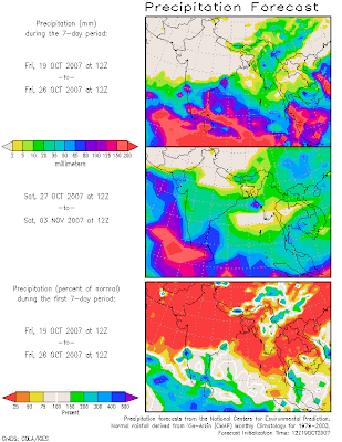
Shifts are happening this week that hint at the start of the North East Monsoon in India. The South West Monsoon, which has been slightly slow in withdrawing, has clung to power in the North East. This has been helped by an upper trough in the sub-tropical jet stream (`western disturbance`) over northern India. Numerical forecasts have been consistent in showing that the upper trough will soon be kicked eastwards leading the westerly flow over the northern Subcontinent to `flatten`. This should boost pressure to the north relative to that over southern India and nearby tropical seas. This would weaken, if not reverse, what remains of the South West Monsoon.
Another factor for flipping the wind flow over India is a tropical depression, or cyclone, that is indicated for the Bay of Bengal on or about the middle of next week. To be sure, this is not a `done deal`, but it has been shown rather consistently for a few days. Anyways, such a low would further bolster the weakening and ultimate reversal of the seasonal wind flow.
A would-be harbinger of the North East Monsoon, which brings with it the seasonal rains to southeastern India, can be seen on the COLA Website. This is the Short Term Climate Outlook, which is compiled from GFS numerical forecasts. In the second week of the two-week outlook, there is a big blow-up of rainfall over East and South East, India.

情色電影, aio交友愛情館, 言情小說, 愛情小說, 色情A片, 情色論壇, 色情影片, 視訊聊天室, 免費視訊聊天, 免費視訊, 視訊美女, 視訊交友, ut聊天室, 視訊聊天, 免費視訊聊天室, a片下載, av片, A漫, av dvd, av成人網, 聊天室, 成人論壇, 本土自拍, 自拍, A片,
ReplyDelete愛情公寓, 情色, 舊情人, 情色貼圖, 情色文學, 情色交友, 色情聊天室, 色情小說, 一葉情貼圖片區, 情色小說, 色情, 色情遊戲, 情色視訊, 情色電影, aio交友愛情館, 色情a片, 一夜情, 辣妹視訊, 視訊聊天室, 免費視訊聊天, 免費視訊, 視訊, 視訊美女, 美女視訊, 視訊交友, 視訊聊天, 免費視訊聊天室, 情人視訊網, 影音視訊聊天室, 視訊交友90739, 成人影片, 成人交友,
免費A片, 本土自拍, AV女優, 美女視訊, 情色交友, 免費AV, 色情網站, 辣妹視訊, 美女交友, 色情影片, 成人影片, 成人網站, A片,H漫, 18成人, 成人圖片, 成人漫畫, 情色網,