
Friday, November 07, 2014


05B - From Tropical Cyclone to a Well marked LOW in 15hrs
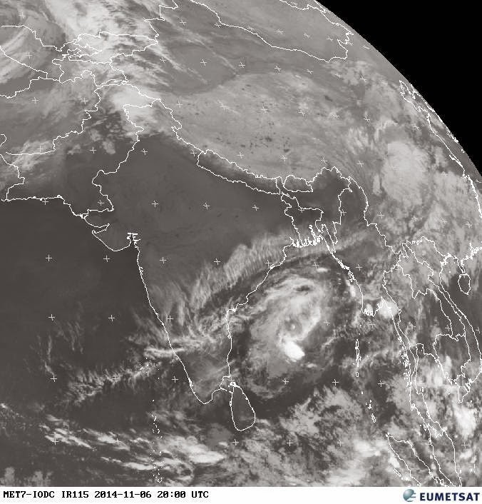
Latest analysis show that 05B Tropical Cyclone has degraded during past 8hrs and now its just a well marked LOW.
Present position is almost the same as on evening of 5-Nov !!
And pressure around 1006mb.
Now, JTWC, NAVGEM and GFS expect the system to drift West during next 24hrs and reach S Andhra coast, Chennai around Saturday evening / night as a Well marked LOW.
There's a 20% chance of reaching coast as depression.


Thursday, November 06, 2014
91B is now tracked as a Deep depression "05B"

Analysis at 2:30pm, suggests that the system has almost intensified into a Tropical Cyclone.
Pressure around 996.9mb and winds reaching upto 90 kmph.
Present position is almost parallel to Chennai, 13.48N , 88E

Latest wind analysis show a good concentration of winds around its center.
3:30pm, Visible shows heavy convective activity around its center.
JTWC warning at 2:30pm
~~~~~~~~~~~~~~~~~~~~~~~~~~~~~~
TROPICAL CYCLONE 05B (FIVE), LOCATED APPROXIMATELY 350 NM SOUTH
OF VISAKHAPATNAM, INDIA, HAS TRACKED EASTWARD AT 10 KNOTS OVER THE
PAST SIX HOURS. ANIMATED VISUAL SATELLITE IMAGERY DEPICTS A
CONSOLIDATING LOW-LEVEL CIRCULATION CENTER (LLCC) SOUTHEAST OF THE
MAJOR AREAS OF CONVECTION. THE CURRENT POSITION HAVE BEEN RELOCATED
75NM SOUTHEAST OF PREVIOUS 060600Z POSITION DUE TO THE VISIBLE LLCC.
THE INITIAL INTENSITY OF 35 KNOTS IS BASED ON THE STEADY DVORAK
INTENSITY ESTIMATES FROM PGTW. UPPER-LEVEL ANALYSIS INDICATES THE
SYSTEM REMAINS IN A GENERALLY FAVORABLE ENVIRONMENT WITH MODERATE
(10-20 KNOT) VERTICAL WIND SHEAR AND DIVERGENCE ALOFT PROVIDING GOOD
EQUATORWARD AND POLEWARD OUTFLOW. TC 05B IS CURRENTLY QAUSI-
STATIONARY DUE TO A WEAK STEERING ENVIRONMENT IN A COL REGION
BETWEEN TWO SUB TROPICAL RIDGES (STR). BEYOND TAU 36, AS THE SYSTEM
MATURES, EXPECT IT TO TRACK ALONG THE SOUTHERN PERIPHERY OF THE STR
THAT CURRENTLY LIES TO EAST OF THE SYSTEM, AS THE STR TRACKS INTO
THE NORTHERN BAY OF BENGAL. THE CYCLONE IS EXPECTED TO REMAIN
ON A GENERAL WESTWARD TRAJECTORY UNDER THE STEERING INFLUENCE OF THE
STR THROUGHOUT THE FORECAST PERIOD. FAVORABLE UPPER-LEVEL CONDITIONS
ARE EXPECTED TO CONTINUE, ALLOWING TC 05B TO SLIGHTLY INTENSIFY
THROUGH TAU 48. JUST BEYOND TAU 72, TC 05B WILL MAKE LANDFALL SOUTH
OF VISAKHAPATNAM AND DISSIPATE BY THE END OF THE FORECAST
PERIOD. DUE TO LIMITED MODEL GUIDANCE WITH REGARD TO THIS EARLY
SYSTEM, THERE IS LOW CONFIDENCE IN THE JTWC FORECAST. JUSTIFICATION
FOR AMENDED AND RELOCATION: RELOCATED INITIAL POSITION OF TC 05B
FURTHER TOT HE SOUTHEAST BASED ON VISIBLE LLCC. THIS CAUSED A
FORECAST PHILOSOPHY CHANGE WITH REGARD TO TRACK SPEED AND FORECAST
EXTENT. MAXIMUM SIGNIFICANT WAVE HEIGHT AT 060600Z IS 10 FEET.

GFS model, JTWC suggest a Westward track from now on and weaken before reaching S Andhra coast and Chennai.

NAVGEM model suggests the same Westward track from now and "weaken" and then make a S-W track towards central Tamilnadu coast !!
Wednesday, November 05, 2014

A strong W.D system is nearing N,central Pakistan, will start affecting in next 6 hrs ... http://ow.ly/i/7tkUt
The W.D will start affecting Kashmir, Punjab, Himachal from evening, night of 6-Nov ... http://ow.ly/i/7tl91
The upcoming W.D is expected to last till Saturday morning over Kashmir and Himachal.

#Chennai - Today, it was DRY, bit cold and with high cloud cover .
Min temp today morning.
Airport = 21.4 C
IWM Polichalur = 21.7 C
Almost NO rain expected for most of Tamilnadu, Kerala, S Andhra and Chennai during next 2 days !
COLD morning, DRY day ahead!
Chance of Scattered showers for S Kerala and S-tip Tamilnadu during next 2 days !
Min temp today morning.
Airport = 21.4 C
IWM Polichalur = 21.7 C
Almost NO rain expected for most of Tamilnadu, Kerala, S Andhra and Chennai during next 2 days !
COLD morning, DRY day ahead!
Chance of Scattered showers for S Kerala and S-tip Tamilnadu during next 2 days !
91B - now a well marked LOW, Can it become a Cyclone ??

Analysis of 91B suggests that during past 12hrs it has intensified to Well marked LOW, with pressure around 1003mb. And showing signs of intensifying.
5pm, IR shows good convective activity around its location.

At present it is located over Central Bay.

GFS model suggests a Northerly movement (for 2 days) with NO great intensification beyond Depression and then make a N-W movement as a LOW pressure system and reach upto Odisha coast.

But NAVGEM model suggests a N-N-E movement for next 2 days, then weaken and drift Westwards towards Andhra coast on 9-Nov !!
The wind shear along the System and North of it (around 20N) is HIGH, this'll not allow the system to intensify and sustain.

Subscribe to:
Posts (Atom)