What is a tropical cyclone?
A tropical cyclone is the generic term for a low pressure system over tropical or sub-tropical waters, with organised convection (i.e. thunderstorm activity) and winds at low levels, circulating either anti-clockwise (in the northern hemisphere) or clockwise (in the southern hemisphere). The terms hurricane and typhoon are regionally-specific names for a strong tropical cyclone.
Tropical cyclones with maximum sustained surface winds of less than 39 m.p.h. are called tropical depressions. Once the winds around the tropical cyclone reach at least 39 m.p.h. it is called a tropical storm and is assigned a name. If winds reach 74 m.p.h., then it is called a:
hurricane - in the North Atlantic Ocean and the north-east Pacific Ocean, east of the dateline;
typhoon - in the north-west Pacific Ocean, west of the dateline;
tropical cyclone - in other regions, including the Indian Ocean and South Pacific Ocean.
How do they get their names?
Tropical cyclones are named to provide ease of communication between forecasters and the general public, regarding forecasts, watches and warnings. Since the storms can often last a week or even longer, and more than one can be occurring in the same region at the same time, names can reduce the confusion about what storm is being described.
Names were first used in World War II and were subsequently adopted by all regions. In most regions pre-determined alphabetic lists of alternating male and female names are used. However, in the north-west Pacific the majority of names used are not personal names. While there are a few male and female names, most are names of flowers, animals, birds, trees, foods or descriptive adjectives. The names are also not allocated in alphabetical order, but are arranged by the name of the Asian country which contributed the name.
Full list of names
How do they form?
Tropical cyclones require a number of conditions to develop, these include:
a source of warm, moist air derived from tropical oceans with sea surface temperatures normally in the region of, or in excess, of 27 °C;
winds near the ocean surface blowing from different directions converging and causing air to rise and storm clouds to form;
winds which do not vary greatly with height - known as low wind shear. This allows the storm clouds to rise vertically to high levels;
spin induced by the rotation of the Earth
The formation mechanisms vary across the world, but once a cluster of storm clouds starts to rotate it becomes a tropical depression. If it continues to develop it becomes a tropical storm, and later a hurricane or typhoon.
Hurricanes are synonymous with the Caribbean and the USA, but where else do they occur and do they happen here in the UK and Europe?
Tropical cyclones which occur in the Atlantic region and affect the Caribbean and USA usually comprise less than 15% of global tropical cyclone activity. Tropical cyclones also occur in various parts of the Pacific Ocean, and can affect coastal regions of Mexico, south-east Asia, north-east Australia and the south Pacific islands. Those that form in the Indian Ocean can affect India, Bangladesh, north-west Australia, some parts of east Africa and Indian Ocean islands such as Mauritius and Madagascar.
Hurricanes are tropical features and generally require sea temperatures much higher than those around the UK, even in the summer. Hence, hurricanes cannot form at our latitudes. However, we do sometimes experience the remnants of old hurricanes coming out of the Tropics; as they get entrained into the Atlantic westerly flow at higher latitudes they can reach the UK and Western Europe as "extra-tropical storms". Although the Great Storm of October 1987 may have been enhanced by warm moist air originating in the Tropics, it was not by any definition a hurricane.
How are hurricanes graded?
In many parts of the world the Saffir-Simpson scale is used to grade hurricanes.
Category 1 - sustained wind speeds of 74 to 95 m.p.h.
Category 2 - sustained wind speeds of 96 to 110 m.p.h.
Category 3 - sustained wind speeds of 111 to 130 m.p.h.
Category 4 - sustained wind speeds of 131 to 155 m.p.h.
Category 5 - sustained wind speeds greater than 155 m.p.h.
While hurricanes of the high categories can cause catastrophic damage due to their wind speed, it should be noted that weaker hurricanes, and even tropical storms, can cause major problems due to heavy rainfall. The storm surge associated with tropical cyclones can also be very damaging.
When are the tropical cyclone seasons?
In the northern hemisphere most tropical cyclones occur between June and November with a peak in September. However, in the north-west Pacific it is not unusual to have the occasional tropical cyclone outside of this period. In the southern hemisphere the season usually lasts from November to April.
Deadliest tropical cyclones
The most deadly tropical cyclone occurred in 1970, and caused an estimated 300,000 deaths in Bangladesh. The most deadly hurricane to hit the USA was the Galveston hurricane in 1900 which claimed 8,000 lives.
Some USA hurricane facts
2005 - Hurricane Katrina was the most costly on record, causing an estimated $80 billion of damage. It also claimed 1,300 lives - the greatest number for a USA hurricane since the 1928 Florida hurricane
1992 - Hurricane Andrew was a Category 5 hurricane which hit south- east Florida and south-east Louisiana, causing $45 billion of damage
1969 - Camille was a Category 5 hurricane with winds of 190 m.p.h. It hit Mississippi; south-east Louisiana, and Virginia, causing damage totalling $15 billion
1935 - The Labor Day Storm was a Category 5 hurricane which hit the Florida Keys
Is climate change affecting tropical cyclones?
The impact of climate change - specifically global warming caused by the burning of fossil fuels - on tropical cyclone activity is the subject of ongoing debate and research in the scientific community. Recent catastrophic events, such as Hurricane Katrina, have given the debate a higher profile. While some evidence has been presented in order to indicate a recent upturn in tropical cyclone activity in some parts of the world, others have argued that natural variations in tropical cyclone activity - on a regional, annual and inter-decadal scale - mask any signal from the impact of global warming, which remains relatively small.
Although there is no clear consensus on whether global warming is currently having any measurable impact on tropical cyclones, climate models indicate that there may be an increase in tropical cyclone intensity in the future, under continued global warming. However, the models also indicate that tropical cyclone frequency will either remain unchanged or decrease.
A number of tropical cyclone scientists came together in 2006 to issue a statement on the status of understanding and research into tropical cyclones and climate change, which was presented to the World Meteorological Organization.
Statement on tropical cyclones and climate change
Does the Met Office forecast tropical cyclones?
"Official" responsibility for forecasting tropical cyclones in the areas affected lies with the regional centres such as the National Hurricane Center in Miami. However, the Met Office does produce tropical cyclone forecasts from its global model, which are disseminated to the regional centres. They then use these forecasts, along with other forms of guidance, to produce their forecasts. Met Office forecasts of tropical cyclones show considerable skill and are among the best models available to agencies such as the National Hurricane Center.
Info from http://www.metoffice.gov.uk/corporate/pressoffice/hurricanes/

Tuesday, December 02, 2008
Monday, December 01, 2008
"96B" - A far away new LOW
Chennai:
As expected, we received a mild shower yesterday night(10:30PM).
Today(1-Dec-08), from morning only patchy "spongy" cloud formations can be seen, nothing threatening.
Still some heavy showers can be seen over Interior & South Tamilnadu.
This weather also will clear out for a DAY or TWO before the next weather system moves in.
Already US Navy is tracking a NEW low system as "96B".
It's situated at South-west of Andaman islands. Far away from us.
No significant formations can be seen in latest satellite pic.
Almost all numeric models are showing the Dec-6th Cyclone or depression, making landfall near North-Tamilnadu and South-Andhra.
The NEW system might reach us, around 6th or 7th of December.
Here are some latest numeric models from different agencies..


As expected, we received a mild shower yesterday night(10:30PM).
Today(1-Dec-08), from morning only patchy "spongy" cloud formations can be seen, nothing threatening.
Still some heavy showers can be seen over Interior & South Tamilnadu.
This weather also will clear out for a DAY or TWO before the next weather system moves in.
Already US Navy is tracking a NEW low system as "96B".
It's situated at South-west of Andaman islands. Far away from us.
No significant formations can be seen in latest satellite pic.
Almost all numeric models are showing the Dec-6th Cyclone or depression, making landfall near North-Tamilnadu and South-Andhra.
The NEW system might reach us, around 6th or 7th of December.
Here are some latest numeric models from different agencies..


"Cyclones in December" - Another good research
Another good research done by one of our active reader "pradeep john"
"I have dig some more cyclones which were formed in december and moving towards Bangladesh
1990
http://metocph.nmci.navy.mil/jtwc/atcr/1990atcr/pdf/nio/04b.pdf
1981
http://metocph.nmci.navy.mil/jtwc/atcr/1981atcr/pdf/nio/31-81.pdf
1973
http://metocph.nmci.navy.mil/jtwc/atcr/1973atcr/pdf/nio/41-73.pdf
Approx in every 10 years a cyclone in December moves towards Bangladesh last being in 1990
i have been tracking cyclones from my Hindu Pages from 1995 and i have not seen one go northwards in december
it seems our predicted future cyclone will not move up towards Bangladesh or even Orissa..it is coming towards Tamilnadu or South Andhra"
"I have dig some more cyclones which were formed in december and moving towards Bangladesh
1990
http://metocph.nmci.navy.mil/jtwc/atcr/1990atcr/pdf/nio/04b.pdf
1981
http://metocph.nmci.navy.mil/jtwc/atcr/1981atcr/pdf/nio/31-81.pdf
1973
http://metocph.nmci.navy.mil/jtwc/atcr/1973atcr/pdf/nio/41-73.pdf
Approx in every 10 years a cyclone in December moves towards Bangladesh last being in 1990
i have been tracking cyclones from my Hindu Pages from 1995 and i have not seen one go northwards in december
it seems our predicted future cyclone will not move up towards Bangladesh or even Orissa..it is coming towards Tamilnadu or South Andhra"
Sunday, November 30, 2008
Cyclones - Northern Bay during December
This is the piece of Information i got from the IMD website about a cyclone that crossed West Bengal coast. But this was the only Cyclone to cross the West Bengal Coast in December since 1971.
December 4-11. 1981
Crossed West Bengal Coast near Sagar Island around 1300 UTC on December 10 and weakened into a depression on 11th morning over Bangladesh and into a low the same evening over Assam and Meghalaya.200 people died in 24 Parganas district of West Bengal One Million people affect in the districts of 24 Parganas.
Contributed by one of our reader:Chandramouli
December 4-11. 1981
Crossed West Bengal Coast near Sagar Island around 1300 UTC on December 10 and weakened into a depression on 11th morning over Bangladesh and into a low the same evening over Assam and Meghalaya.200 people died in 24 Parganas district of West Bengal One Million people affect in the districts of 24 Parganas.
Contributed by one of our reader:Chandramouli
After "Nisha" - what next??
Chennai, today received some drizzles overnite.
Clear, bright and sunny morning!
Now (1:07 PM) some patches of low cloud formation can be seen, not threatening to rain.
The moisture left behind by "Nisha" and favorable wind direction (east-north-east), might trigger some thundershowers for Interior Tamilnadu.
But chennai will remain mostly clear & sunny, a possibility of some drizzles OR sharp showers late evening.
Here is the latest satellite pic...

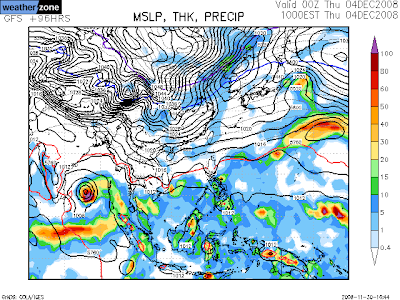
And here is the latest numeric model for the NEXT cyclone (if any..?!)
Both the models suggest there is a Depression formation around 4-Dec-08.

Clear, bright and sunny morning!
Now (1:07 PM) some patches of low cloud formation can be seen, not threatening to rain.
The moisture left behind by "Nisha" and favorable wind direction (east-north-east), might trigger some thundershowers for Interior Tamilnadu.
But chennai will remain mostly clear & sunny, a possibility of some drizzles OR sharp showers late evening.
Here is the latest satellite pic...

And here is the latest numeric model for the NEXT cyclone (if any..?!)
Both the models suggest there is a Depression formation around 4-Dec-08.


"After Nisha" - from Jim's blog, Accuweather.com
The storm is over and what lingers behind is tropical moisture that has wafted over most of peninsular India giving rise to scattered thunderstorms as of Saturday. The old low-level core of Nisha has settled as a much-weakened whirl over the eastern Arabian Sea.
The next few days of weather will lack the drama of the last week and its flooding, cyclonic rains and winds. But there will be an unusual bent to it inasmuch as tropical moisture will run unusually far northward over the western Subcontinent. The hit-or-miss showers and thunderstorms that have already arisen over Maharashtra will reach Gujarat and even southern Sindh. I would not rule out a shower at Karachi sometime within the next three to four days.
Well, there is already talk of the next depression or cyclone over the Bay of Bengal on or after the middle of next week. My take is "I do not know yet". I will wait to see consistency in numerical model runs; barring this, I will decline to forecast a Bay cyclone. Even without a well-marked tropical low, the setting does seem to favor new outbreaks of rain, but nothing like the one now ended.
--The rain unleashed by the big, lumbering weather system the became Tropical Cyclone Nisha has triggered tragic flooding. The statistics themselves were staggering. The storm's four-day outburst of rain poured 57.9 cm/22.8 inches upon Chennai-Minambakkam. And rains ahead of Nisha swelled the amount to 59.6 cm/26.6 inches, or more than two fold the normal monthly rainfall--all of this within about one week. And, by my reckoning, rainfall at Cuddalore since last Friday has reached 33 inches (about 84 cm), give or take.
The next few days of weather will lack the drama of the last week and its flooding, cyclonic rains and winds. But there will be an unusual bent to it inasmuch as tropical moisture will run unusually far northward over the western Subcontinent. The hit-or-miss showers and thunderstorms that have already arisen over Maharashtra will reach Gujarat and even southern Sindh. I would not rule out a shower at Karachi sometime within the next three to four days.
Well, there is already talk of the next depression or cyclone over the Bay of Bengal on or after the middle of next week. My take is "I do not know yet". I will wait to see consistency in numerical model runs; barring this, I will decline to forecast a Bay cyclone. Even without a well-marked tropical low, the setting does seem to favor new outbreaks of rain, but nothing like the one now ended.
--The rain unleashed by the big, lumbering weather system the became Tropical Cyclone Nisha has triggered tragic flooding. The statistics themselves were staggering. The storm's four-day outburst of rain poured 57.9 cm/22.8 inches upon Chennai-Minambakkam. And rains ahead of Nisha swelled the amount to 59.6 cm/26.6 inches, or more than two fold the normal monthly rainfall--all of this within about one week. And, by my reckoning, rainfall at Cuddalore since last Friday has reached 33 inches (about 84 cm), give or take.
Saturday, November 29, 2008
The last of "NISHA" - Chennai: 28CM rainfall
Chennai Airport received 28cm of extreme heavy rainfall till 8:30AM, 28-Nov-08.
Now "Nisha" is just a LOW pressure and dissipating fast over south-interior Andhra & parts of East-Karnataka.
It was pouring over those area, yesterday (29-Nov-08).
CHENNAI:
Water logging in draining slowly.
We are receiving some intermittent showers from Yesterday morning.
Evening it was heavy.
Today morning also it was heavy.
Now (2:15PM) also we had a sharp shower.
Still the Cloud movement is from south-east, as long as this does'nt change we'll continue to receive more rains.
Latest satellite pic...

We are tracking a Numeric model for another Cyclone over the south-bay.

Now "Nisha" is just a LOW pressure and dissipating fast over south-interior Andhra & parts of East-Karnataka.
It was pouring over those area, yesterday (29-Nov-08).
CHENNAI:
Water logging in draining slowly.
We are receiving some intermittent showers from Yesterday morning.
Evening it was heavy.
Today morning also it was heavy.
Now (2:15PM) also we had a sharp shower.
Still the Cloud movement is from south-east, as long as this does'nt change we'll continue to receive more rains.
Latest satellite pic...

We are tracking a Numeric model for another Cyclone over the south-bay.

Friday, November 28, 2008

Something about "NISHA" from Jim's blog
Something about "NISHA" from Jim's blog, www.accuweather.com
Thanks to some "fancy footwork", the center of Tropical Cyclone Nisha held offshore for something like another 10 or 12 hours following its earlier purported landfall. While satellite imagery seemed to confirm the earlier time, surface winds and pressure field belied it. I note here that slowly moving tropical cyclones will often tend to keep a center over water until the whole mass is committed to shift inland.
Anyways, there is no doubt that, as of 1800 UTC, Thursday, the center of Nisha is inland and dissipating. Wind and tide are thus no longer a big factor; however, satellite imagery makes it clear that torrential downpours are still taking place. One has poured 10 cm of rain upon Cuddalore within three hours. This hikes to 68 cm/26.8 inches the rainfall here since late last week (5 to 6 days).
Readers may wish to browse comments from the foregoing post. Here is one segment relating to torrential rain and widespread severe flooding:
"The following stations recorded extremely heavy rainfall in centimetres:
Orathanadu (Thanjavur dt) 66, Thanjavur 53, Vedaranyam 42, Adiramapattinam 33, Muthupet (Tiruvarur dt) 30 and Kumbakonam (Thanjavur dt) 26."
I have never seen a 24-hr rainfall total of 66 cm anywhere in Tamil Nadu. Simply unbelievable. Chennai's 24-hr rainfall was 14 cm. Needless to say, widespread flooding and devastation of winter crops, especially in the Thanjavur-Thiruvarur-Nagapattinam belt (the so-called 'rice bowl' of South India), off where the storm hovered for 2 days before landfall.
Looking forward, the old core of Nisha will drift northwest during the next few days, which means it will leave land for the eastern Arabian Sea. Showers and downpours will fade over coastal southeast India even as the leading edge of showers and thunderstorms shifts north and west to Karnataka and Maharashtra. There is even the believable scenario of scattered showers and thunderstorms reaching Gujarat and southermost Sindh, Pakistan.
One thing to raise before leaving South Asia: strong north-south pressure gradient will stir up strong easterly winds along and right down wind of the crest of the Western Ghats in Maharashtra and Karnataka through Friday night, local time.
Oh, and still another thing. Recall that, as of the start of the week, I was speaking about another tropical cyclone "threat". Well, I will now say the we have had the cyclone--in the shape of TC Nisha, which proved to "steal the show".
-----------------------------------------------
Well, not only did Tuesday's tropical depression get upgraded to tropical cyclone, it became a rather strong tropical storm before its landfall upon southeastern India between 0600 UTC and 1200 UTC, Wednesday. Shortly before landfall, Tropical Cyclone Nisha was reckoned, by the JTWC, to have highest sustained winds of 55 knots/100 km/h. Landfall happened over the state of Tamil Nadu between Karaikal (Puducherry) and Vedaranniyam. Thus, the time between upgrade over northern Sri Lanka and landfall in India was between 12 and 18 hours.
While there potentially damaging winds near the landfall of Nisha (gales observed at Karaikal as of 0900 UTC), the storm, both before and after its upgrade, was, foremost of all, a rainmaker. In northern Sri Lanka, a report of about 24 inches/60 cm of rain within two to three days at Jaffna seems believable. In southeast India, where the North East Monsoon has been stirring up local heavy rain for several days, rainfall has reached at least 21.9 inches/55.6 cm at Cuddalore, Tamil Nadu, and 16.4 inches/41.7 at Karaikal, Puducherry, as of 1800 UTC--and still falling. This is serious flooding rainfall. And at Chennai, rainfall since late last week is at least 10.5 inches/26.7 cm. For Chennai, this brings November rainfall to near normal.
Nisha will dissipate within about 24 hours over the southern Deccan of India. But there will be showers and thunderstorms with local heavy falls over Tamil Nadu and Andhra Pradesh with significant, if spotty, rain into Kerala and Karnataka. And, if the latest (1200 UTC, Wednesday) GFS forecast scenario hold true, this weekend into early next week will see scattered showers and thunderstorms spreading not only over western Maharashtra, but into Gujarat and even southern Sindh, Pakistan.
Thanks to some "fancy footwork", the center of Tropical Cyclone Nisha held offshore for something like another 10 or 12 hours following its earlier purported landfall. While satellite imagery seemed to confirm the earlier time, surface winds and pressure field belied it. I note here that slowly moving tropical cyclones will often tend to keep a center over water until the whole mass is committed to shift inland.
Anyways, there is no doubt that, as of 1800 UTC, Thursday, the center of Nisha is inland and dissipating. Wind and tide are thus no longer a big factor; however, satellite imagery makes it clear that torrential downpours are still taking place. One has poured 10 cm of rain upon Cuddalore within three hours. This hikes to 68 cm/26.8 inches the rainfall here since late last week (5 to 6 days).
Readers may wish to browse comments from the foregoing post. Here is one segment relating to torrential rain and widespread severe flooding:
"The following stations recorded extremely heavy rainfall in centimetres:
Orathanadu (Thanjavur dt) 66, Thanjavur 53, Vedaranyam 42, Adiramapattinam 33, Muthupet (Tiruvarur dt) 30 and Kumbakonam (Thanjavur dt) 26."
I have never seen a 24-hr rainfall total of 66 cm anywhere in Tamil Nadu. Simply unbelievable. Chennai's 24-hr rainfall was 14 cm. Needless to say, widespread flooding and devastation of winter crops, especially in the Thanjavur-Thiruvarur-Nagapattinam belt (the so-called 'rice bowl' of South India), off where the storm hovered for 2 days before landfall.
Looking forward, the old core of Nisha will drift northwest during the next few days, which means it will leave land for the eastern Arabian Sea. Showers and downpours will fade over coastal southeast India even as the leading edge of showers and thunderstorms shifts north and west to Karnataka and Maharashtra. There is even the believable scenario of scattered showers and thunderstorms reaching Gujarat and southermost Sindh, Pakistan.
One thing to raise before leaving South Asia: strong north-south pressure gradient will stir up strong easterly winds along and right down wind of the crest of the Western Ghats in Maharashtra and Karnataka through Friday night, local time.
Oh, and still another thing. Recall that, as of the start of the week, I was speaking about another tropical cyclone "threat". Well, I will now say the we have had the cyclone--in the shape of TC Nisha, which proved to "steal the show".
-----------------------------------------------
Well, not only did Tuesday's tropical depression get upgraded to tropical cyclone, it became a rather strong tropical storm before its landfall upon southeastern India between 0600 UTC and 1200 UTC, Wednesday. Shortly before landfall, Tropical Cyclone Nisha was reckoned, by the JTWC, to have highest sustained winds of 55 knots/100 km/h. Landfall happened over the state of Tamil Nadu between Karaikal (Puducherry) and Vedaranniyam. Thus, the time between upgrade over northern Sri Lanka and landfall in India was between 12 and 18 hours.
While there potentially damaging winds near the landfall of Nisha (gales observed at Karaikal as of 0900 UTC), the storm, both before and after its upgrade, was, foremost of all, a rainmaker. In northern Sri Lanka, a report of about 24 inches/60 cm of rain within two to three days at Jaffna seems believable. In southeast India, where the North East Monsoon has been stirring up local heavy rain for several days, rainfall has reached at least 21.9 inches/55.6 cm at Cuddalore, Tamil Nadu, and 16.4 inches/41.7 at Karaikal, Puducherry, as of 1800 UTC--and still falling. This is serious flooding rainfall. And at Chennai, rainfall since late last week is at least 10.5 inches/26.7 cm. For Chennai, this brings November rainfall to near normal.
Nisha will dissipate within about 24 hours over the southern Deccan of India. But there will be showers and thunderstorms with local heavy falls over Tamil Nadu and Andhra Pradesh with significant, if spotty, rain into Kerala and Karnataka. And, if the latest (1200 UTC, Wednesday) GFS forecast scenario hold true, this weekend into early next week will see scattered showers and thunderstorms spreading not only over western Maharashtra, but into Gujarat and even southern Sindh, Pakistan.


Subscribe to:
Posts (Atom)