

Tuesday, March 25, 2008
Unusual Path ...
Here is an illustration of the unusual path traced by the unusual LOW pressure system.

Super March
Most part of March so far was Rainy... rainy!
This phenomenon is quiet unusal.
Let's see what happnd so far? and what's coming up?
Chennai has crossed the Normal rainfall average by a huge amount.
Yesterday Rain - 2.6 mm
24 Hour Rain - 2.6mm
Monthly Rain - 133.8mm (Mar. normal - 3 mm)
Yesterday (24-Mar-08) morning around 10 AM, all of a sudden it rained with lightning and it continued till 1 pm. In some parts of chennai rain was heavy and in others it was slight drizzles only. Most of the heavy rain was around south Chennai.
Today morning and now it's clear with some passing clouds.
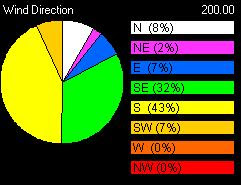
Take a look at the past 5 days wind direction...
Yesterday's satellite pic


Today's satellite pic

This shows a huge mass of cloud formation over the south bay of bengal. The present activity and favorable conditions might make that mass of clouds to become a low pressure system in coming days.
Overall..We are at the end of winter and now starts the dreaded chennai summer.
This phenomenon is quiet unusal.
Let's see what happnd so far? and what's coming up?
Chennai has crossed the Normal rainfall average by a huge amount.
Yesterday Rain - 2.6 mm
24 Hour Rain - 2.6mm
Monthly Rain - 133.8mm (Mar. normal - 3 mm)
Yesterday (24-Mar-08) morning around 10 AM, all of a sudden it rained with lightning and it continued till 1 pm. In some parts of chennai rain was heavy and in others it was slight drizzles only. Most of the heavy rain was around south Chennai.
Today morning and now it's clear with some passing clouds.
Take a look at the past 5 days wind direction...

Yesterday's satellite pic


Today's satellite pic

This shows a huge mass of cloud formation over the south bay of bengal. The present activity and favorable conditions might make that mass of clouds to become a low pressure system in coming days.
Overall..We are at the end of winter and now starts the dreaded chennai summer.
Saturday, March 22, 2008

It's like monsoon here..wow
In chennai rain started after a week on Wednesday... slowly picking up pace and it was raining thru the nite of Thursday into Friday (good friday).
Rain was heavy and with 2 hrs interval... thru the day on Friday.
Here is some rain stats for Chennai.
Yesterday Rain - 59.8 mm
24 Hour Rain - 13.6mm
Monthly Rain - 126.4mm (Mar. normal - 3 mm)
Take a look at the system as of NOW.

These rainy conditions are quiet bizzare and not common in March.
The LOW formed over Gulf of Mannar moved over south extreme of South Tamilnadu and moved into parts of Maldives. This is the position as of Morning, Friday.
This system after gaining strength moved rapidly to the north and laid centered over parts of Lakshadweep.
As i write this blog, the system is still active and carrying a lots of cloud mass around it.
The numeric forecast shows there might be a another system moving in from South Bay.. in next 120 hrs.
So an unusual April ahead....!!!!
Rain was heavy and with 2 hrs interval... thru the day on Friday.
Here is some rain stats for Chennai.
Yesterday Rain - 59.8 mm
24 Hour Rain - 13.6mm
Monthly Rain - 126.4mm (Mar. normal - 3 mm)
Take a look at the system as of NOW.

These rainy conditions are quiet bizzare and not common in March.
The LOW formed over Gulf of Mannar moved over south extreme of South Tamilnadu and moved into parts of Maldives. This is the position as of Morning, Friday.
This system after gaining strength moved rapidly to the north and laid centered over parts of Lakshadweep.
As i write this blog, the system is still active and carrying a lots of cloud mass around it.

The numeric forecast shows there might be a another system moving in from South Bay.. in next 120 hrs.
So an unusual April ahead....!!!!
Wednesday, March 19, 2008
Rainfall amounts from South Tamilnadu
Ramanathapuram, Sathankulam (Tuticorin dt) and Sivakasi (Virudhunagar dt) 7
Theni, Pudukottai, Tondi, Ambasamudram (Tirunelveli dt) and Sattur (Virudhunagar dt) 5 each, Mudukulathur (Ramanathapuram dt), and Pamban 4 each, Thirumayam (Pudukottai dt), Kamudhi, Paramakudi and Tiruvadanai (all Ramanathapuram dt), Nanguneri and Sivagiri (Tirunelveli dt), Srivaikuntam and Tiruchendur (all Tuticorin dt), Tuticorin, Madurai, Melur (Madurai dt), Periyakulam (Theni dt), Ilayangudi, Manamadurai, and Tiruppuvanam (all Sivaganga dt), Sivaganga, Rajapalayam, Srivilliputhur and Watrap (all Virudhunagar dt) and Virudhunagar 3 each, Aranthangi (Pudukottai dt), Radhapuram (Tirunelveli dt), Kovilpatti, Ottapidaram and Surangudi (all Tuticorin dt), Kothagiri (Nilgiris dt), Kadavur (Karur dt), Chittampatti, Mettupatti, Sholavandan, Thirumangalam, Usilampatti and Vadipatti (all Madurai dt), Andipatti and Uthamapalayam ( both Theni dt), Devakottai and Karaikudi (both Sivagangai dt), Kodaikanal Natham (Dindigul dt), Minicoy and Munnar (Idukki dt) 2 each and Adiramapattinam, Orathanadu (Thanjavur dt), Muthupet and Needamangalam (both Tiruvarur dt), Arimalam and Keeranur (both Pudukottai dt), Manamelkudi, Kadaladi (Ramanathapuram dt), Sankarankoil, Shenkottai and Tenkasi (all Tirunelveli dt), Vilathikulam (Tuticorin dt), Kanyakumari, Mylaudi (Kanyakumari dt), Thammampatti (Salem dt), Valparai, Coonoor, Ketti (Nilgiris dt), Manaparai and Marungapuri (both Tiruchirapalli dt), Madurai Airport, Peraiyur (Madurai dt), Tirupattur (Sivaganga dt), Piravom (Ernakulam dt), Panambur, Bajpe and Puttur (Dakshina Kannada dt) 1
Theni, Pudukottai, Tondi, Ambasamudram (Tirunelveli dt) and Sattur (Virudhunagar dt) 5 each, Mudukulathur (Ramanathapuram dt), and Pamban 4 each, Thirumayam (Pudukottai dt), Kamudhi, Paramakudi and Tiruvadanai (all Ramanathapuram dt), Nanguneri and Sivagiri (Tirunelveli dt), Srivaikuntam and Tiruchendur (all Tuticorin dt), Tuticorin, Madurai, Melur (Madurai dt), Periyakulam (Theni dt), Ilayangudi, Manamadurai, and Tiruppuvanam (all Sivaganga dt), Sivaganga, Rajapalayam, Srivilliputhur and Watrap (all Virudhunagar dt) and Virudhunagar 3 each, Aranthangi (Pudukottai dt), Radhapuram (Tirunelveli dt), Kovilpatti, Ottapidaram and Surangudi (all Tuticorin dt), Kothagiri (Nilgiris dt), Kadavur (Karur dt), Chittampatti, Mettupatti, Sholavandan, Thirumangalam, Usilampatti and Vadipatti (all Madurai dt), Andipatti and Uthamapalayam ( both Theni dt), Devakottai and Karaikudi (both Sivagangai dt), Kodaikanal Natham (Dindigul dt), Minicoy and Munnar (Idukki dt) 2 each and Adiramapattinam, Orathanadu (Thanjavur dt), Muthupet and Needamangalam (both Tiruvarur dt), Arimalam and Keeranur (both Pudukottai dt), Manamelkudi, Kadaladi (Ramanathapuram dt), Sankarankoil, Shenkottai and Tenkasi (all Tirunelveli dt), Vilathikulam (Tuticorin dt), Kanyakumari, Mylaudi (Kanyakumari dt), Thammampatti (Salem dt), Valparai, Coonoor, Ketti (Nilgiris dt), Manaparai and Marungapuri (both Tiruchirapalli dt), Madurai Airport, Peraiyur (Madurai dt), Tirupattur (Sivaganga dt), Piravom (Ernakulam dt), Panambur, Bajpe and Puttur (Dakshina Kannada dt) 1
Raining over South Tamilnadu
Chennai got good rains for 3 days last week, after that it's hot & humid.
The day time temperature is going up... and the cloud movement is from EAST-SOUTH-EAST.
Early and mid mornings are with medium cloud cover and after that it's clear all the way.
This is the pattern for the past week after the rains.
Take a look at some news pics from the past week rains in chennai.


We are nearing the end of good temperature days for this season.
For past week or so, south tamilnadu is getting massive amounts of rainfall.
This is due to the passing low pressure weather system from south bay of bengal and srilanka.
Even we are hearing "it's like monsoon season down here" from people of south extreme tamilnadu.
The day time temperature is going up... and the cloud movement is from EAST-SOUTH-EAST.
Early and mid mornings are with medium cloud cover and after that it's clear all the way.
This is the pattern for the past week after the rains.
Take a look at some news pics from the past week rains in chennai.


We are nearing the end of good temperature days for this season.
For past week or so, south tamilnadu is getting massive amounts of rainfall.
This is due to the passing low pressure weather system from south bay of bengal and srilanka.
Even we are hearing "it's like monsoon season down here" from people of south extreme tamilnadu.
Friday, March 14, 2008
Rainy March...!!!
This rainy spell is very unsual at this time of year.
Chennai is experiencing frequent heavy & sharp showers from evening of 12-Mar-08.
Initially it was light... and now (14-Mar-08) it's heavy with more frequency and even with Thunder.
Past 24 hr rain record = 20.2mm
Yesterday = 15.6 mm
Crossing the monthly average...Monthly Rain - 32.4mm (Mar. normal - 3 mm)
Let's look at WHY this phenomenon????
There's lot of moisture over the southern bay of bengal & the wind direction is almost equal to a north-east monsoon.
Look at it...

The COLA- Numeric forecast suggests a Deep Low formation over the southern Bay of bengal over the next 48 hrs.
Take a look...

As i finish writing this post, there's a huge thunderstorm rolling in from East
Chennai is experiencing frequent heavy & sharp showers from evening of 12-Mar-08.
Initially it was light... and now (14-Mar-08) it's heavy with more frequency and even with Thunder.
Past 24 hr rain record = 20.2mm
Yesterday = 15.6 mm
Crossing the monthly average...Monthly Rain - 32.4mm (Mar. normal - 3 mm)
Let's look at WHY this phenomenon????
There's lot of moisture over the southern bay of bengal & the wind direction is almost equal to a north-east monsoon.
Look at it...

The COLA- Numeric forecast suggests a Deep Low formation over the southern Bay of bengal over the next 48 hrs.
Take a look...

As i finish writing this post, there's a huge thunderstorm rolling in from East
Tuesday, March 11, 2008
Final Chill...! and Now what??
I was away with work for the past 15 days.
Now back on time.
For the past 2 weeks, chennai experienced low temperatures & dry weather.
Low of the month was : 20.2°C (4/3/08)

Take a look the past 5 day Temperature & Wind direction.
You can look at the gradual increase in temperature.
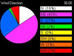
The wind direction is also good, favoring a shower..!
From today morning, there's a lot of cloud cover.
There's a 100% chance of small showers in the coming days.

This may be the shower that brings the all expected SUMMER to Chennai.
Now back on time.
For the past 2 weeks, chennai experienced low temperatures & dry weather.
Low of the month was : 20.2°C (4/3/08)

Take a look the past 5 day Temperature & Wind direction.
You can look at the gradual increase in temperature.

The wind direction is also good, favoring a shower..!
From today morning, there's a lot of cloud cover.
There's a 100% chance of small showers in the coming days.

This may be the shower that brings the all expected SUMMER to Chennai.
Friday, February 15, 2008
2 heavy showers....unusual
From early morning (6AM) today it was like a monsoon morning.
Heavy rain clouds forming from the EAST-South-east.
2 showers with 1hr gap, it was slightly heavy.
Still the southern bay has lots of North-east activity... this is causing rain at some places over NORTH tamilnadu and to south-south tamilnadu.
Some of the amounts of rain are...
Tuticorin 5, Ambasamudram (Tirunelveli dt) 4, Kovilpatti (Tuticorin dt), Mylaudi (Kanyakumari dt), Srivaikuntam and Surangudi (both Tuticorin dt) and Nanguneri (Tirunelveli dt) 1.
Going by the latest satellite pic... it's nothing there.
Let's see what's the status tomorrow morning.
Heavy rain clouds forming from the EAST-South-east.
2 showers with 1hr gap, it was slightly heavy.
Still the southern bay has lots of North-east activity... this is causing rain at some places over NORTH tamilnadu and to south-south tamilnadu.
Some of the amounts of rain are...
Tuticorin 5, Ambasamudram (Tirunelveli dt) 4, Kovilpatti (Tuticorin dt), Mylaudi (Kanyakumari dt), Srivaikuntam and Surangudi (both Tuticorin dt) and Nanguneri (Tirunelveli dt) 1.
Going by the latest satellite pic... it's nothing there.
Let's see what's the status tomorrow morning.
Thursday, February 14, 2008
WEATHER FORECASTING - traditional way
Indicators of Deteriorating Weather:
Clouds lowering and thickening, ceiling lowers.
Puffy clouds begin to develop vertically and darken.
Sky is dark and threatening to the West.
Clouds increasing in numbers, moving rapidly across the sky.
Clouds at different heights moving in different directions.
Clouds moving from East or Northeast towards the South.
Heavy rain occurring at night.
Barometer falling steadily or rapidly.
Smoke from stacks lowers.
Static on AM radio.
Wind shifting North to East and possibly through East to South.
There is a ring (halo) around the moon.
If on land, leaves that grow according to prevailing winds turn over and show their backs.
Strong wind and / or a red sky in the morning.
Temperatures far above or below normal for the time of year.
Indicators of Impending Strong Winds:
Light, scattered clouds alone in a clear sky.
Sharp, clearly defined edges to clouds.
Yellow sunset.
Unusually bright stars.
Major changes in the temperature.
Indicators of Impending Precipitation:
Distant objects seem to stand above the horizon.
Sounds are very clear and can be heard for great distances.
Transparent veil-like cirrus clouds thicken, ceiling lowers.
Hazy and sticky air. Rain may occur in 18-36 hours.
Halo around the sun or moon.
Increasing South wind with clouds moving from the West.
Wind (especially North wind) shifting to West and then South.
Steadily falling barometer.
Pale sunset.
Red sky to the West at dawn.
No dew after a hot day.
Indicators of Clearing Weather:
Cloud bases rise.
Smoke from stacks rise.
Wind shifts to West, especially from East through South.
Barometer rises quickly.
A cold front has passed in the past 4 to 7 hours.
Gray early morning sky shows signs of clearing.
Morning fog or dew.
Rain stopping and clouds breaking away at sunset.
Indicators of Continuing Fair Weather:
Early morning fog that clears.
Gentle wind from the West or Northwest.
Barometer steady or rising slightly.
Red sky to East with clear sky to the West at sunset.
Bright moon and light breeze at night.
Heavy dew or frost.
Clear blue morning sky to West.
Clouds dot the afternoon summer sky.
Clouds lowering and thickening, ceiling lowers.
Puffy clouds begin to develop vertically and darken.
Sky is dark and threatening to the West.
Clouds increasing in numbers, moving rapidly across the sky.
Clouds at different heights moving in different directions.
Clouds moving from East or Northeast towards the South.
Heavy rain occurring at night.
Barometer falling steadily or rapidly.
Smoke from stacks lowers.
Static on AM radio.
Wind shifting North to East and possibly through East to South.
There is a ring (halo) around the moon.
If on land, leaves that grow according to prevailing winds turn over and show their backs.
Strong wind and / or a red sky in the morning.
Temperatures far above or below normal for the time of year.
Indicators of Impending Strong Winds:
Light, scattered clouds alone in a clear sky.
Sharp, clearly defined edges to clouds.
Yellow sunset.
Unusually bright stars.
Major changes in the temperature.
Indicators of Impending Precipitation:
Distant objects seem to stand above the horizon.
Sounds are very clear and can be heard for great distances.
Transparent veil-like cirrus clouds thicken, ceiling lowers.
Hazy and sticky air. Rain may occur in 18-36 hours.
Halo around the sun or moon.
Increasing South wind with clouds moving from the West.
Wind (especially North wind) shifting to West and then South.
Steadily falling barometer.
Pale sunset.
Red sky to the West at dawn.
No dew after a hot day.
Indicators of Clearing Weather:
Cloud bases rise.
Smoke from stacks rise.
Wind shifts to West, especially from East through South.
Barometer rises quickly.
A cold front has passed in the past 4 to 7 hours.
Gray early morning sky shows signs of clearing.
Morning fog or dew.
Rain stopping and clouds breaking away at sunset.
Indicators of Continuing Fair Weather:
Early morning fog that clears.
Gentle wind from the West or Northwest.
Barometer steady or rising slightly.
Red sky to East with clear sky to the West at sunset.
Bright moon and light breeze at night.
Heavy dew or frost.
Clear blue morning sky to West.
Clouds dot the afternoon summer sky.
Subscribe to:
Posts (Atom)