Wednesday, December 12, 2007

"92B" is moving

Here's the latest report from US navy ...

THE AREA OF CONVECTION PREVIOUSLY LOCATED NEAR 4.9N 85.5E,
IS NOW LOCATED NEAR 7.2N 84.9E, APPROXIMATELY 295 NM EAST OF
COLOMBO, SRI LANKA. RECENT ANIMATED MULTISPECTRAL AND WATER VAPOR
SATELLITE IMAGERY SHOW CONVECTION FLARING ON THE NORTHERN PERIPHERY
OF A WELL-DEFINED LOW LEVEL CIRCULATION CENTER (LLCC) EVIDENT IN A
120409Z ASCAT PASS. THE DISTURBANCE LIES UNDER AN AREA OF FAVORABLE
POLEWARD DIFFLUENCE ALOFT AND MODERATE VERTICAL WIND SHEAR
ASSOCIATED WITH THE PERIPHERAL WINDS OF AN UPPER LEVEL ANTICYCLONE
CENTERED WELL TO THE EAST OVER THE WESTERN NORTH PACIFIC OCEAN.
MAXIMUM SUSTAINED SURFACE WINDS ARE ESTIMATED AT 20 TO 25 KNOTS.
MINIMUM SEA LEVEL PRESSURE IS ESTIMATED TO BE NEAR 1005 MB. THE
POTENTIAL FOR THE DEVELOPMENT OF A SIGNIFICANT TROPICAL CYCLONE
WITHIN THE NEXT 24 HOURS REMAINS FAIR.

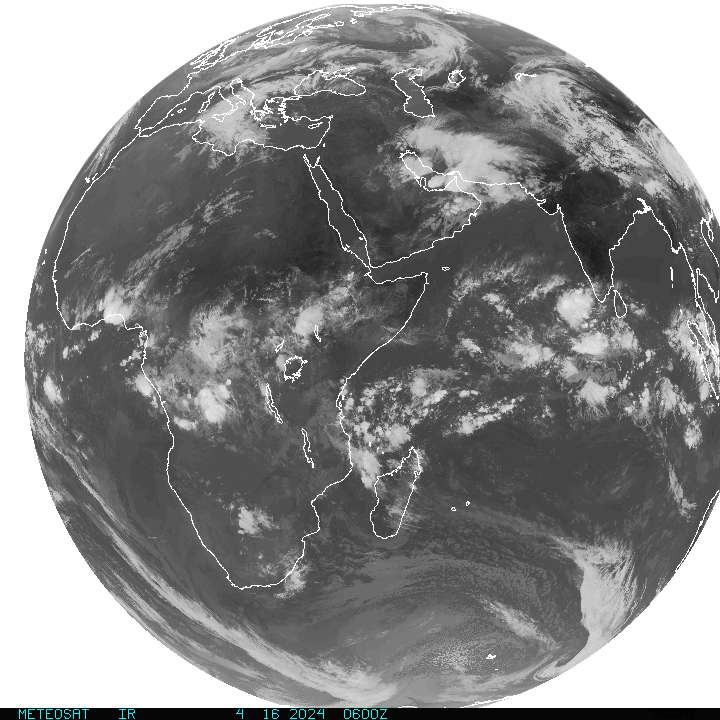
Take a look at the latest Satellite pic from F-15 pass over (US Navy)

Infrared from Weather.com

Full Indian ocean IR imagery

Almost a Depression "92B"

Past positions
10-Dec ---> 5.3N 85.4E
11-Dec ---> 5.7N 85.4E
12-Dec ---> 4.5N 85.6E
Category: T1.0/1.5
It has moved...
TROPICAL DISTURBANCE UPDATE
Bay of Bengal - 1800 GMT
System 92B
Position 4.9N 85.5E
Location 355 miles ESE of Colombo, Sri Lanka
Likelihood of a tropical cyclone forming within 24 hours: FAIR
This disturbance has maintained its structure, although atmospheric conditions continue to be less than favourable. Any improvement could give rise to a fully fledged cyclone
Take a look at the latest satellite...

Tuesday, December 11, 2007

Latest on "92B"

What's is happening with LOW 92B.
It's just a low pressure system, lying south-east of Srilanka.
I still have lots of IF's and BUT's about the system because it's very slow to develop and move.
Here is the latest satellite imagery...

In Chennai, today morning it was cloudy and almost rain. Though the cloud was not heavy by no means but it was surely shower bearing ones. By mid-noon everything cleared off and it was just hazy towards the evening.
Temperature was Hi: 29.5°C @ 1:31pm
and Humidity was Low: 56% @ 1:37pm... very low indeed at noon.

Monday, December 10, 2007

US Navy/NRL is tracking "92B"

Take a look at the latest satellite pic from US Navy

Potential Tropical Cyclone

This is the latest advisory from JTWC Issued at 10/1800Z
MSGID/GENADMIN/NAVPACMETOCCEN PEARL HARBOR HI/JTWC//
SUBJ/SIGNIFICANT TROPICAL WEATHER ADVISORY FOR THE INDIAN
/OCEAN/101800Z-111800ZDEC2007//
1. NORTH INDIAN OCEAN AREA (MALAY PENINSULA WEST TO COAST OF AFRICA):
A. TROPICAL CYCLONE SUMMARY: NONE.
B. TROPICAL DISTURBANCE SUMMARY:
(1) THE AREA OF CONVECTION PREVIOUSLY LOCATED NEAR 3.3N 85.3E,
IS NOW LOCATED NEAR 3.7N 86.1E, APPROXIMATELY 420 NM EAST-SOUTHEAST
OF COLOMBO, SRI LANKA. ANIMATED INFRARED SATELLITE IMAGERY INDICATES
A DEVELOPING LOW-LEVEL CIRCULATION CENTER (LLCC) WITH FLARING DEEP
CONVECTION NEAR THE CENTER. A 101414Z SSMIS IMAGE DEPICTS A DEFINED
LLCC WITH FORMATIVE CONVECTIVE BANDING WRAPPING INTO THE EAST
QUADRANT. UPPER-LEVEL ANALYSIS DEPICTS AN ANTICYCLONE LOCATED NEAR
3N 86E, JUST SOUTHEAST OF THE CENTER, WHICH IS PRODUCING GOOD
DIFFLUENCE BUT MODERATE VERTICAL WIND SHEAR. MAXIMUM SUSTAINED
SURFACE WINDS ARE ESTIMATED AT 20 TO 25 KNOTS. MINIMUM SEA LEVEL
PRESSURE IS ESTIMATED TO BE NEAR 1004 MB. THE POTENTIAL FOR THE
DEVELOPMENT OF A SIGNIFICANT TROPICAL CYCLONE WITHIN THE NEXT 24
HOURS REMAINS FAIR.

Activity over South Bay increasing

After we have reported yesterday about the "Activity over south bay"... now it's showing signs of developing into a Depression.
Still the whole mass of system is South of Bay of Bengal.
Take a look at this INFRARED satellite pic...

Chennai today experienced a bit Hot day with temperature Hi: 30.1°C @ 12:24pm.
Wind condition is still mostly North-East.
No rain and no sign of it today.
And expect rain during the weekend!

Sunday, December 09, 2007

Latest Earth Quake ... daily update

Update time = Sun Dec 9 9:00:26 UTC 2007
MAG UTC DATE-TIME
y/m/d h:m:s LAT
deg LON
deg DEPTH
km Region
MAP 3.7 2007/12/09 07:40:46 63.023 -148.152 100.0 CENTRAL ALASKA
MAP 7.6 2007/12/09 07:28:24 -26.156 -177.453 187.6 SOUTH OF THE FIJI ISLANDS
MAP 4.8 2007/12/09 05:34:30 12.360 125.589 31.7 SAMAR, PHILIPPINES
MAP 4.9 2007/12/09 05:27:18 -19.107 -68.964 81.6 TARAPACA, CHILE
MAP 5.2 2007/12/09 05:22:16 12.285 125.329 84.3 SAMAR, PHILIPPINES
MAP 2.5 2007/12/09 05:15:20 51.389 -178.765 59.7 ANDREANOF ISLANDS, ALEUTIAN IS., ALASKA
MAP 3.1 2007/12/09 03:07:30 52.529 -174.434 91.1 ANDREANOF ISLANDS, ALEUTIAN IS., ALASKA
MAP 4.8 2007/12/09 02:23:01 2.300 126.848 70.4 MOLUCCA SEA
MAP 4.9 2007/12/09 02:03:29 -15.049 -44.199 10.0 MINAS GERAIS, BRAZIL
MAP 2.7 2007/12/09 01:12:25 62.288 -150.218 56.1 CENTRAL ALASKA

You can view a comprehensive list here

Lots of activity over south Bay

For the past 6 days there was bit and pieces of showers which has resulted in 65.4mm (Dec. normal - 138 mm).
Yesterday and Today (9-Dec-07) till now there was no rain, not dry and even the temperature was also on the high side.
Yesterday's temperature Hi: 29.7°C @ 12:04pm Low: 23.3°C @ 6:26am.
Yesterday's Humidity Hi: 95% @ 4:54am Low: 59% @ 1:29pm

Now coming to the South-Bay activity. Take a look at the latest satellite pic ...

What's happening there? Will it develop into a Depression or something??
I think it'll because the present prevailing conditions is leading to that.

The following is from a Weather blog hosted by www.accuweather.com
"It has been dry lately over southern India, where rains of the North East Monsoon shut off. Now, the same shift in atmospheric patterns allowing rain to reach the northern Subcontinent (this being a trough in the Westerlies--a `western disturbance`), may draw some wetting rains back into Sri Lanka and southeastern India from the southeast. Further ahead in time, there is even the possibility of scattered rain (popping up mid to late week) over the heart of India."

And even the latest numeric forecast also suggests that, take a look ...

Saturday, December 08, 2007

The rare "Red Bananas"


Selection Information

Usage: Used for baking.
Selection: Good-quality Red Bananas are slightly soft and the skin will be purple or maroon-red. Slight scars do not affect quality.
Avoid: Avoid product that is extremely soft, completely black or spotted with mold around the stem.

Seasonal Information
Available year-round from Ecuador and Mexico.

Red Banana Nutritional Information
Serving Size: 1 medium banana (126g)
Amount Per Serving
Calories 110
Calories from Fat 0%
Total Fat 0
0%
Cholesterol 0mg
0%
Sodium 0mg
0%
Total Carbohydrate 29g
10%
Dietary Fiber 4g
16%
Potassium 400mg
10%
Sugars 21g
Protein 1g
Vitamin A 0%
Vitamin C 15%
Calcium 0%
Iron 0%
Vitamin B6 20%
*Percent Daily Values are based on a 2,000 calorie diet. Your daily values may be higher or lower depending on your calorie needs.

Source: PMA's Labeling Facts
Low Fat, Sodium-free, Source of fiber and potassium,
Source of vitamin C & B6, Cholesterol-free.
For full nutritional facts of Bananas clik here

Banana Tips & Trivia
To ripen green bananas, put them into a plastic bag, seal it and place the bag in a warm place like on top of your refrigerator. This will cause the bananas to heat up which speeds the ripening process. You can also put other green fruit like peaches and pears into the bag with a ripe banana, and they will ripen faster as well!
You can freeze bananas! Just peel and store in plastic bags up to 6 months.
Thaw and drain frozen extra-ripe bananas and use in baked goods... or slice frozen into blender drinks. Have for breakfast, snack, refreshment or as a frosty ice cream-like dessert without all the extra fat or calories.
Sauté green-tipped bananas until brown in just enough margarine or cooking spray to coat. Serve as a side dish or "starch" with chicken, pork or even fish.
As the green color of bananas turns to yellow, the starch in the fruit turns to sugar.

Alexander the Great discovered bananas in his conquest of India in 327 B.C.

Bananas don't grow on trees, as is commonly believed. They grow on compacted, water-filled leaf stalks that grow up to 25 feet high. They are the world's largest herb. (Source: The Packer, 9/9/89)