The above title came from an article on the UK’s TimesOnline with the same title, “La Niña Threatens to Wreck World’s Weather” From the very beginning the story it tries to grab the reader’s attention by trying to scare them in the first paragraph, “Experts predict a run of severe weather in the coming months, with devastating floods striking some parts of the world while severe droughts afflict other regions, as the climate phenomenon known as La Niña gathers momentum.” From there the next two paragraphs are about current extreme weather and how it could “exacerbate” the California drought. Then about about cold and snow in the Pacific Northwest and western Canada, which is common in La Niña events. Then it talks about more floods and drought and even mentions how La Nina could “rearrange the pattern of sea ice around the Antarctic.”
Here is my problem with this story, it seems over the top doom and gloom. La Niña patterns in the Pacific “alters” world weather patterns not “wreck” it. They do mention that the La Niña is in its developing stages and that it will continue to get stronger, and they also quote a source that says it isn’t going to be real strong. (That I agree with. From all that I have seen and read I think we are in the ball park of a weak to moderate La Niña.) After they state that La Niña is in its early developmental stages, and they go on to blame it for weather events this summer, for example the strength of Dean and Felix and flooding monsoons in Asia.
How can you blame La Niña for weather events this summer? When NOAA in its press release about the”developing La Nina” says, “While we can’t officially call it a La Niña yet, we expect that this pattern will continue to develop during the next three months, meeting the NOAA definition for a La Niña event later this year.”
I want people to understand that world weather patterns are not this simple. There is more to what happens with the atmosphere and the overall weather pattern than just one La Niña or El Niño event. While we live in an age where the drum beat of Climate change gets louder and louder we need to become more familiar with our weather and have a better understanding of how the atmosphere works. If we don’t and just accept all that we are told from one side of the debate or the other we will be taken advantage of.
I am not a Global Warming denier or an alarmist either. I don’t think the solution is in government mandates and higher taxes in the name of curbing Climate Change, but we shouldn’t just sit around and do nothing. I think the solution could be in technology and the markets. Finding new and cleaner ways to do the things we currently do now and there is definitely a demand for cleaner eco-friendly products.

Saturday, November 03, 2007

No signs

Today, again clear day.
Only difference is that the SKY is Deep blue in color.
Usually DEEP blue colored skies are common during Monsoons and this can be another sign for next weather front is moving in OR the old weather front has moved away.
After having a look at INSAT pics and Some numeric forecasts ... there is no sign of Bay LOW.
The formation of LOW is a must for the monsoon to get vigorous and satisfy the land.
Till now northern tamilnadu is scanty of rainfall.
For october Chennai should get 283 MM but it got 267.6 MM.
Now for November average is 350 MM.
take a look at the BLANK latest satellite pic provided by www.accuweather.com
Friday, November 02, 2007
Pakistan in India
The Pakistan cricket team arrived in Delhi later on Thursday for five one dayers and three Test matches.
Talking to the reporters, Pakistan skipper Shoaib Malik said that Twenty20 World Cup defeat against India is history and whichever team would handle pressure better will win the forthcoming series.
Alleging there is no tension between the two teams, he said Indian team is in great form, especially Yuvraj Singh.
Malik called cricket between India and Pakistan enjoyable and said his team wants the most of it.
He also said he had no problems with the senior players in his team, who give him their cooperation.
Frontline seamer Asif not in team
Unfortuntely for Pakistan, they are without their frontline seamer Mohammad Asif, who is most likely to miss the entire one day series due to continuing problems with his elbow.
Asif missed the recent one-day series against South Africa due to the same injury, after breaking down while bowling in the second Test against the Proteas at the Gaddafi Stadium last month.
The pacer had earlier undergone an MRI scan, and the report wasn't very encouraging.
An official confirmation of Asif's pull out is expected later in the day. The PCB hasn't announced any replacement so far.
Talking to the reporters, Pakistan skipper Shoaib Malik said that Twenty20 World Cup defeat against India is history and whichever team would handle pressure better will win the forthcoming series.
Alleging there is no tension between the two teams, he said Indian team is in great form, especially Yuvraj Singh.
Malik called cricket between India and Pakistan enjoyable and said his team wants the most of it.
He also said he had no problems with the senior players in his team, who give him their cooperation.
Frontline seamer Asif not in team
Unfortuntely for Pakistan, they are without their frontline seamer Mohammad Asif, who is most likely to miss the entire one day series due to continuing problems with his elbow.
Asif missed the recent one-day series against South Africa due to the same injury, after breaking down while bowling in the second Test against the Proteas at the Gaddafi Stadium last month.
The pacer had earlier undergone an MRI scan, and the report wasn't very encouraging.
An official confirmation of Asif's pull out is expected later in the day. The PCB hasn't announced any replacement so far.
Northeast back online
From Yesterday (1-Nov-2007) night, the Northeast air current is back online after that Small depression which crossed on 28-Oct-2007.
As a good sign Today (2-Nov-2007) morning...it was clear around 8AM then at 9AM there was signs of small drizzle or shower.
In the end at around 9:15 AM Rain came down rather heavily. Actually it was a pleasant surprise.
Yesterday's low temperature was 24.6°C @ 5:49am
As far as today's forecast is concerned, some intermitent rain showers will be there till noon... and clear/partially cloudy afterwards.
Hope the northeast strengthens further more in days to come.
Here is a numeric Rain forecast from wxmaps for 24 hrs

As a good sign Today (2-Nov-2007) morning...it was clear around 8AM then at 9AM there was signs of small drizzle or shower.
In the end at around 9:15 AM Rain came down rather heavily. Actually it was a pleasant surprise.
Yesterday's low temperature was 24.6°C @ 5:49am
As far as today's forecast is concerned, some intermitent rain showers will be there till noon... and clear/partially cloudy afterwards.
Hope the northeast strengthens further more in days to come.
Here is a numeric Rain forecast from wxmaps for 24 hrs

Thursday, November 01, 2007
Cyclone 05A update
TC 05A has shifted westward Wednesday and has begun to through high, thin clouds down wind to southeastern Arabia. This is well shown by way of this infrared cloud shot from the IMD.
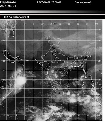
While one might believe that that big, bright (and thus cold and high on this infrared shot) mass marks a strong, growing storm. Not true. By the JTWC, 05A was a minimal tropical storm (highest sustained winds of 35 knots, or 65 kmh) as of 1200 hours, GMT, Wednesday. The low-level center was east of the big, bright cloud mass--a sure marker of strong easterly wind shear. Such shear makes meaningful grow of such storms tough, indeed.
Numerical forecasts are faster in dealing with 05A than had earlier been true. Thus, the low level center is forecast ashore Saturday or Sunday somewhere eastward from Salalah, Oman. The ECMWF, however, seems to dissipate 05A over water rather than steering its ashore. And it seems clear that weakening is shown. For their part, the JTWC weaken and ultimately dissipate 05A over water south of Salalah Friday and Saturday.
So impact upon land (mostly Oman) will hinge upon whether 05A bodily makes landfall (even if no longer a TC) or dissipates off shore. The former would favor heavy falls of rain near the landfall with hit-or-miss thunderstorms inland. The latter would have less impactful rain. Thursday should hold more clues as to whether 05A will make a landfall.
Patterns of down stream moisture owing to 05A suggest at least a day or two of hit-or-miss showers and thunderstorms over Uman, UAE, easternmost KSA and eastern Yemen. First rains would happen Friday in southern Oman.

While one might believe that that big, bright (and thus cold and high on this infrared shot) mass marks a strong, growing storm. Not true. By the JTWC, 05A was a minimal tropical storm (highest sustained winds of 35 knots, or 65 kmh) as of 1200 hours, GMT, Wednesday. The low-level center was east of the big, bright cloud mass--a sure marker of strong easterly wind shear. Such shear makes meaningful grow of such storms tough, indeed.
Numerical forecasts are faster in dealing with 05A than had earlier been true. Thus, the low level center is forecast ashore Saturday or Sunday somewhere eastward from Salalah, Oman. The ECMWF, however, seems to dissipate 05A over water rather than steering its ashore. And it seems clear that weakening is shown. For their part, the JTWC weaken and ultimately dissipate 05A over water south of Salalah Friday and Saturday.
So impact upon land (mostly Oman) will hinge upon whether 05A bodily makes landfall (even if no longer a TC) or dissipates off shore. The former would favor heavy falls of rain near the landfall with hit-or-miss thunderstorms inland. The latter would have less impactful rain. Thursday should hold more clues as to whether 05A will make a landfall.
Patterns of down stream moisture owing to 05A suggest at least a day or two of hit-or-miss showers and thunderstorms over Uman, UAE, easternmost KSA and eastern Yemen. First rains would happen Friday in southern Oman.
Another clear day
Another clear morning for Chennai, I think this is going to be the feature for the day.
-- there was still a low-level whirl and weak low off Andhra Pradesh, South East India. Today, no such low is seen. Now, tropical moisture has fanned out over southern and eastern India to give rise to some showers and thunderstorms today, Wednesday. A setting favoring more such showers and thunderstorms, albeit with daily waxing and waning, is forecast to hold for a few more days with no new Bay of Bengal low forecast through next mid week.
-- there was still a low-level whirl and weak low off Andhra Pradesh, South East India. Today, no such low is seen. Now, tropical moisture has fanned out over southern and eastern India to give rise to some showers and thunderstorms today, Wednesday. A setting favoring more such showers and thunderstorms, albeit with daily waxing and waning, is forecast to hold for a few more days with no new Bay of Bengal low forecast through next mid week.
IMD report (31-Oct-2007)
Northeast monsoon has been Active over South Coastal Andhrapradesh.
Rainfall occurred at most places over Coastal Andhrapradesh, at many places over Telangana and at a few places over Kerala, Lakshadweep and Interior Karnataka. Isolated rainfall occurred over Tamilnadu, Mainly dry weather prevailed over Rayalaseema and dry weather prevailed over Coastal Karnataka.
Ichapuram (Srikakulam dt) and Cuddalore recorded a heavy rainfall of 11 and 7 centimeters respectively.
The other chief amounts of rainfall recorded in centimetres are:
Devarakonda (Nalgonda dt) 6, Kandukur (Prakasam dt) 5, Panruti (Cuddalore dt), Adirampatnam, Manamelkudi, Kalingapatnam, Narasapur, Machilipatnam, Mandasa and Sompeta (both Srikakulam dt) and Macherla (Guntur dt) 4 each, Vedaranyam, Arantangi and Karambakudi (both Pudukottai dt), Shenkottah (Tirunelveli dt), Devakottai (Sivagangai dt), Bapatla, Palasa and Tekkali (both Srikakulam dt), Bhimavaram and Koderu (West Godavari dt), Guntur, Tennali, Atchampet, and Satnapalli (all Guntur dt), Addanki and Podili (both Prakasam dt),Aryankavu (Kollam dt), Bangalore Airport 3 each, Villupuram, Arimalam (Pudukottai dt), Kuzithurai (Kanyakumari dt), Gannavaram, Pathapatnam and Verraghatam (both Srikakulam dt), Parvathipuram (Vizianagaram dt), Mangalagiri, Piduguralla and Rapalli (all Guntur dt), Darsi and Yerragondapalam (both Prakasam dt), Mahabubnagar, Miryalaguda and Ramannapet (both Nalgonda dt) and Nelamangala (Bangalore Rural dt ) 2 each and Thirukoilur (Villupuram dt), Puducherry Airport, Pattukottai (Thanjavur dt), Allankudi (Pudukottai dt), Nagerkoil, Thuckalay (Kanyakumari dt),Visakhapattinam, Visakhapattinam Airport, Ongole, Hyderabad Airport, Ranasthalam (Srikakulam dt), Cheepurupalli and Terlam (both Vizianagaram dt), Anakapalli, Bheemunipatnam and Chodavaram (all Visakhapattinam dt), Amalapuram (East Godavari dt), Bhimidole, Tadepallegudem and Tanaku (all West Godavari dt),Nandigama, Rentachintala, Khammam, Bhongir and Suryapet (Nalgonda dt), Chevella, Ibrahimpatnam, Tandur, Vikarabad and Pargi (all Rangareddy dt),Kozhikode Airport, Kochi Airport, Kayankulam (Alapuzha dt),Thiruvananthapuram Airport, Bangalore 1 each.
Madurai Airport recorded maximum temperature of 35 degree Celsius in the region.
Arogyavaram recorded the lowest minimum temperature of 15 degree Celsius in the plains of the region.
Rainfall occurred at most places over Coastal Andhrapradesh, at many places over Telangana and at a few places over Kerala, Lakshadweep and Interior Karnataka. Isolated rainfall occurred over Tamilnadu, Mainly dry weather prevailed over Rayalaseema and dry weather prevailed over Coastal Karnataka.
Ichapuram (Srikakulam dt) and Cuddalore recorded a heavy rainfall of 11 and 7 centimeters respectively.
The other chief amounts of rainfall recorded in centimetres are:
Devarakonda (Nalgonda dt) 6, Kandukur (Prakasam dt) 5, Panruti (Cuddalore dt), Adirampatnam, Manamelkudi, Kalingapatnam, Narasapur, Machilipatnam, Mandasa and Sompeta (both Srikakulam dt) and Macherla (Guntur dt) 4 each, Vedaranyam, Arantangi and Karambakudi (both Pudukottai dt), Shenkottah (Tirunelveli dt), Devakottai (Sivagangai dt), Bapatla, Palasa and Tekkali (both Srikakulam dt), Bhimavaram and Koderu (West Godavari dt), Guntur, Tennali, Atchampet, and Satnapalli (all Guntur dt), Addanki and Podili (both Prakasam dt),Aryankavu (Kollam dt), Bangalore Airport 3 each, Villupuram, Arimalam (Pudukottai dt), Kuzithurai (Kanyakumari dt), Gannavaram, Pathapatnam and Verraghatam (both Srikakulam dt), Parvathipuram (Vizianagaram dt), Mangalagiri, Piduguralla and Rapalli (all Guntur dt), Darsi and Yerragondapalam (both Prakasam dt), Mahabubnagar, Miryalaguda and Ramannapet (both Nalgonda dt) and Nelamangala (Bangalore Rural dt ) 2 each and Thirukoilur (Villupuram dt), Puducherry Airport, Pattukottai (Thanjavur dt), Allankudi (Pudukottai dt), Nagerkoil, Thuckalay (Kanyakumari dt),Visakhapattinam, Visakhapattinam Airport, Ongole, Hyderabad Airport, Ranasthalam (Srikakulam dt), Cheepurupalli and Terlam (both Vizianagaram dt), Anakapalli, Bheemunipatnam and Chodavaram (all Visakhapattinam dt), Amalapuram (East Godavari dt), Bhimidole, Tadepallegudem and Tanaku (all West Godavari dt),Nandigama, Rentachintala, Khammam, Bhongir and Suryapet (Nalgonda dt), Chevella, Ibrahimpatnam, Tandur, Vikarabad and Pargi (all Rangareddy dt),Kozhikode Airport, Kochi Airport, Kayankulam (Alapuzha dt),Thiruvananthapuram Airport, Bangalore 1 each.
Madurai Airport recorded maximum temperature of 35 degree Celsius in the region.
Arogyavaram recorded the lowest minimum temperature of 15 degree Celsius in the plains of the region.
Wednesday, October 31, 2007
Playing with Fire
An old woman had 3 daughters. One day she decided to test her Sons-in-law.
One day she was walking along a lakeshore with the first son-in-law. Purposefully, she fell down in the lake and started yelling for help.
The first son-in-law jumped into the water and dragged her out into the shore.
The next day he found a brand new E Class Mercedes in his door steps with the wordings "Thank you!!!-Your Mother-in-law who loves you very much!!!"
Another day she was walking along a lakeshore with the second son-in-law. Purposefully, she fell down in the lake and started yelling for help.
The second son-in-law jumped into the water and dragged her out into the shore.
The next day he found a brand new E Class Mercedes in his door steps with the wordings "Thank you!!!-Your Mother-in-law who loves you very much!!!"
The third time she was walking with the third son-in-law and she repeated the same. But that guy didn't respond to her cries for help and didn't move a single step to save her.
The poor old lady who wanted to test her sons-in-law drowned and died.
.
.
.
.
.
The next day he found a brand new Rolls-Royce in his doorsteps with the following wordings ...
.
.
.
"Thank you very much! Your Father-in-law! !!"
One day she was walking along a lakeshore with the first son-in-law. Purposefully, she fell down in the lake and started yelling for help.
The first son-in-law jumped into the water and dragged her out into the shore.
The next day he found a brand new E Class Mercedes in his door steps with the wordings "Thank you!!!-Your Mother-in-law who loves you very much!!!"
Another day she was walking along a lakeshore with the second son-in-law. Purposefully, she fell down in the lake and started yelling for help.
The second son-in-law jumped into the water and dragged her out into the shore.
The next day he found a brand new E Class Mercedes in his door steps with the wordings "Thank you!!!-Your Mother-in-law who loves you very much!!!"
The third time she was walking with the third son-in-law and she repeated the same. But that guy didn't respond to her cries for help and didn't move a single step to save her.
The poor old lady who wanted to test her sons-in-law drowned and died.
.
.
.
.
.
The next day he found a brand new Rolls-Royce in his doorsteps with the following wordings ...
.
.
.
"Thank you very much! Your Father-in-law! !!"
Cloudy & Clear
Yesterday (30-oct-2007) it was a cold and cloudy day. In the morning there was a chance of rain, but afternoon the clouds became high.
Now-today (31-oct-2007) it's clear skies, Humidity is high... This may be signs of things to come in coming 3 or 4 days.
As of now the earlier prediction for another LOW over bay during 1-Nov-2007 is nulled.
Let's see when ....
Take a look at the rain forecast for next 24 hrs


Now-today (31-oct-2007) it's clear skies, Humidity is high... This may be signs of things to come in coming 3 or 4 days.
As of now the earlier prediction for another LOW over bay during 1-Nov-2007 is nulled.
Let's see when ....
Take a look at the rain forecast for next 24 hrs

Subscribe to:
Posts (Atom)