Tuesday, May 13, 2008

The path of destruction..."Nargis"


Some cruel remains of "Nargis"


"Nargis" - Aftermath

The effect of Cyclone Nargis on Burma (Myanmar) has been devastating and international relief is only trickling into the country. The military junta continues to bar access to most international disaster relief specialists and continues to block aid. So a natural disaster threatens to become a a humanitarian crisis of genuinely epic proportions.
With 22,500 dead and 41,000 missing, most of them from a massive storm surge that washed over the Irrawaddy delta, it is the most devastating cyclone to hit Asia since 1991, when 143,000 people died in neighbouring Bangladesh.
Without proper sanitation and clean water people still scavenging in the inundated remains of their homes could fall victim to waterborne diseases-----cholera, dysentery, dengue and malaria epidemics spreading among survivors is a frightening possibility. Burma is on the brink of a “devastating public health crisis” if help is not allowed to flow across its borders immediately.
The UN says that 'thousands of bodies' were floating in nearly 2,000 square miles of the flooded Irrawaddy delta.The junta's refusal of international humanitarian aid is, the UN laments, “unprecedented”. The United Nations has said that it had a responsibility to protect' the civilians victims of crimes against humanity regardless of whether sovereign governments wanted them to or not.

Tuesday, May 06, 2008

Temperature Rising

For the past 5 days Chennai's Maximum and Minimum temperature has been on the rise...
Take a look at the chart.

Max of 41.9 degrees
This will be the case for most of next 10 days.
Take lots of fresh water...to stay away from the harms of such temperatures.

Tuesday, April 29, 2008

IMD daily forecast

IMD on "Nargis"

Morning’s Cyclonic Storm “Nargis” over southwest and adjoining southeast and west-central Bay of Bengal near Lat. 13.00 N and Long 85.50 E, about 550 Km east of Chennai, remained practically stationary and intensified into Severe Cyclonic Storm at 1430 hours IST of today afternoon, the 28th April 2008. The current meteorological analysis and Numerical Weather Prediction models suggest that the system is likely to intensify further and move in a northwesterly direction slowly for some more time. Thereafter, it is likely to recurve and move northeastwards.

TC - 01B "Nargis"

Now the tropical cyclone is given a name... "Nargis"
Take a look at the latest position and it's predicted movement.

In chennai though, it's HOT, very humid and high cloud cover. The high cloud cover is due to the outer ring of the cyclone.
Chennai is clear from it's threat.
According to the JWTC and some numeric forecast, the cyclone was predicted days before that it won't hit Chennai OR even any part of India.

Monday, April 28, 2008

TC - 01

The summer superstar "Tropical Cyclone TC-01".
Take a look at the latest satellite pics ...


And the latest JWTC forecast of the TC...

Sunday, April 27, 2008

All of a sudden

In chennai the summer heat is building by the day.. take a look at the last 5 days Temperature chart.
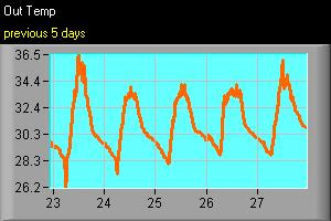
As we have monitored the south bay for the past 3 months, there was considerable activity... NOW all of a sudden a cloud mass has developed into a well marked LOW pressure system., then today it's a Tropical Depression laid center at 750KM east-southeast of Chennai.
Take a look at the development of the system and the latest PIC of the system.


Both JWTC and Indian Met department are tracking it as a potential tropical cyclone.
According to Indian Met office report...
"Yesterday's low pressure area over southeast Bay of Bengal has intensified in to a depression and lay centred at eight thirty hrs IST of 27th April within half a degree of latitude twelve degrees north and longitude eighty seven degrees east at about seven hundred fifty kilometres east-southeast of Chennai. The system is likely to intensify further and move initially in a northwesterly direction."

But according to the JWTC/US Navy prediction...

the system is predicted to move in a North-East direction.

Even the COLA numeric forecast also suggests same as JWTC..
If it moves West or North-west... we (Chennai) might be on the way.
Let's wait for tomorrow and we'll see the direction.
Remember during 1st week of May-2004 a same kind of tropical depression crossed Chennai and South Andhra.

Monday, April 14, 2008

Some heavy showers down south

Thru the last week there was heavy activity over the Southern extreme end of Tamilnadu OR India.
Take a look at the Satellite pic dated ....

It clearly shows a small tropical low system moved from South-Bay crossing Srilanka and Then brushing the Southern Tip.
This caused widespread very heavy rain over that region.

Take a look at the present satellite pic, the South-bay is somewhat calm after 2 months of intense activity.
This calm is not going to be long...!