Ramanathapuram, Sathankulam (Tuticorin dt) and Sivakasi (Virudhunagar dt) 7
Theni, Pudukottai, Tondi, Ambasamudram (Tirunelveli dt) and Sattur (Virudhunagar dt) 5 each, Mudukulathur (Ramanathapuram dt), and Pamban 4 each, Thirumayam (Pudukottai dt), Kamudhi, Paramakudi and Tiruvadanai (all Ramanathapuram dt), Nanguneri and Sivagiri (Tirunelveli dt), Srivaikuntam and Tiruchendur (all Tuticorin dt), Tuticorin, Madurai, Melur (Madurai dt), Periyakulam (Theni dt), Ilayangudi, Manamadurai, and Tiruppuvanam (all Sivaganga dt), Sivaganga, Rajapalayam, Srivilliputhur and Watrap (all Virudhunagar dt) and Virudhunagar 3 each, Aranthangi (Pudukottai dt), Radhapuram (Tirunelveli dt), Kovilpatti, Ottapidaram and Surangudi (all Tuticorin dt), Kothagiri (Nilgiris dt), Kadavur (Karur dt), Chittampatti, Mettupatti, Sholavandan, Thirumangalam, Usilampatti and Vadipatti (all Madurai dt), Andipatti and Uthamapalayam ( both Theni dt), Devakottai and Karaikudi (both Sivagangai dt), Kodaikanal Natham (Dindigul dt), Minicoy and Munnar (Idukki dt) 2 each and Adiramapattinam, Orathanadu (Thanjavur dt), Muthupet and Needamangalam (both Tiruvarur dt), Arimalam and Keeranur (both Pudukottai dt), Manamelkudi, Kadaladi (Ramanathapuram dt), Sankarankoil, Shenkottai and Tenkasi (all Tirunelveli dt), Vilathikulam (Tuticorin dt), Kanyakumari, Mylaudi (Kanyakumari dt), Thammampatti (Salem dt), Valparai, Coonoor, Ketti (Nilgiris dt), Manaparai and Marungapuri (both Tiruchirapalli dt), Madurai Airport, Peraiyur (Madurai dt), Tirupattur (Sivaganga dt), Piravom (Ernakulam dt), Panambur, Bajpe and Puttur (Dakshina Kannada dt) 1

Wednesday, March 19, 2008
Raining over South Tamilnadu
Chennai got good rains for 3 days last week, after that it's hot & humid.
The day time temperature is going up... and the cloud movement is from EAST-SOUTH-EAST.
Early and mid mornings are with medium cloud cover and after that it's clear all the way.
This is the pattern for the past week after the rains.
Take a look at some news pics from the past week rains in chennai.


We are nearing the end of good temperature days for this season.
For past week or so, south tamilnadu is getting massive amounts of rainfall.
This is due to the passing low pressure weather system from south bay of bengal and srilanka.
Even we are hearing "it's like monsoon season down here" from people of south extreme tamilnadu.
The day time temperature is going up... and the cloud movement is from EAST-SOUTH-EAST.
Early and mid mornings are with medium cloud cover and after that it's clear all the way.
This is the pattern for the past week after the rains.
Take a look at some news pics from the past week rains in chennai.


We are nearing the end of good temperature days for this season.
For past week or so, south tamilnadu is getting massive amounts of rainfall.
This is due to the passing low pressure weather system from south bay of bengal and srilanka.
Even we are hearing "it's like monsoon season down here" from people of south extreme tamilnadu.
Friday, March 14, 2008
Rainy March...!!!
This rainy spell is very unsual at this time of year.
Chennai is experiencing frequent heavy & sharp showers from evening of 12-Mar-08.
Initially it was light... and now (14-Mar-08) it's heavy with more frequency and even with Thunder.
Past 24 hr rain record = 20.2mm
Yesterday = 15.6 mm
Crossing the monthly average...Monthly Rain - 32.4mm (Mar. normal - 3 mm)
Let's look at WHY this phenomenon????
There's lot of moisture over the southern bay of bengal & the wind direction is almost equal to a north-east monsoon.
Look at it...

The COLA- Numeric forecast suggests a Deep Low formation over the southern Bay of bengal over the next 48 hrs.
Take a look...

As i finish writing this post, there's a huge thunderstorm rolling in from East
Chennai is experiencing frequent heavy & sharp showers from evening of 12-Mar-08.
Initially it was light... and now (14-Mar-08) it's heavy with more frequency and even with Thunder.
Past 24 hr rain record = 20.2mm
Yesterday = 15.6 mm
Crossing the monthly average...Monthly Rain - 32.4mm (Mar. normal - 3 mm)
Let's look at WHY this phenomenon????
There's lot of moisture over the southern bay of bengal & the wind direction is almost equal to a north-east monsoon.
Look at it...

The COLA- Numeric forecast suggests a Deep Low formation over the southern Bay of bengal over the next 48 hrs.
Take a look...

As i finish writing this post, there's a huge thunderstorm rolling in from East
Tuesday, March 11, 2008
Final Chill...! and Now what??
I was away with work for the past 15 days.
Now back on time.
For the past 2 weeks, chennai experienced low temperatures & dry weather.
Low of the month was : 20.2°C (4/3/08)

Take a look the past 5 day Temperature & Wind direction.
You can look at the gradual increase in temperature.
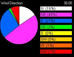
The wind direction is also good, favoring a shower..!
From today morning, there's a lot of cloud cover.
There's a 100% chance of small showers in the coming days.

This may be the shower that brings the all expected SUMMER to Chennai.
Now back on time.
For the past 2 weeks, chennai experienced low temperatures & dry weather.
Low of the month was : 20.2°C (4/3/08)

Take a look the past 5 day Temperature & Wind direction.
You can look at the gradual increase in temperature.

The wind direction is also good, favoring a shower..!
From today morning, there's a lot of cloud cover.
There's a 100% chance of small showers in the coming days.

This may be the shower that brings the all expected SUMMER to Chennai.
Friday, February 15, 2008
2 heavy showers....unusual
From early morning (6AM) today it was like a monsoon morning.
Heavy rain clouds forming from the EAST-South-east.
2 showers with 1hr gap, it was slightly heavy.
Still the southern bay has lots of North-east activity... this is causing rain at some places over NORTH tamilnadu and to south-south tamilnadu.
Some of the amounts of rain are...
Tuticorin 5, Ambasamudram (Tirunelveli dt) 4, Kovilpatti (Tuticorin dt), Mylaudi (Kanyakumari dt), Srivaikuntam and Surangudi (both Tuticorin dt) and Nanguneri (Tirunelveli dt) 1.
Going by the latest satellite pic... it's nothing there.
Let's see what's the status tomorrow morning.
Heavy rain clouds forming from the EAST-South-east.
2 showers with 1hr gap, it was slightly heavy.
Still the southern bay has lots of North-east activity... this is causing rain at some places over NORTH tamilnadu and to south-south tamilnadu.
Some of the amounts of rain are...
Tuticorin 5, Ambasamudram (Tirunelveli dt) 4, Kovilpatti (Tuticorin dt), Mylaudi (Kanyakumari dt), Srivaikuntam and Surangudi (both Tuticorin dt) and Nanguneri (Tirunelveli dt) 1.
Going by the latest satellite pic... it's nothing there.
Let's see what's the status tomorrow morning.
Thursday, February 14, 2008
WEATHER FORECASTING - traditional way
Indicators of Deteriorating Weather:
Clouds lowering and thickening, ceiling lowers.
Puffy clouds begin to develop vertically and darken.
Sky is dark and threatening to the West.
Clouds increasing in numbers, moving rapidly across the sky.
Clouds at different heights moving in different directions.
Clouds moving from East or Northeast towards the South.
Heavy rain occurring at night.
Barometer falling steadily or rapidly.
Smoke from stacks lowers.
Static on AM radio.
Wind shifting North to East and possibly through East to South.
There is a ring (halo) around the moon.
If on land, leaves that grow according to prevailing winds turn over and show their backs.
Strong wind and / or a red sky in the morning.
Temperatures far above or below normal for the time of year.
Indicators of Impending Strong Winds:
Light, scattered clouds alone in a clear sky.
Sharp, clearly defined edges to clouds.
Yellow sunset.
Unusually bright stars.
Major changes in the temperature.
Indicators of Impending Precipitation:
Distant objects seem to stand above the horizon.
Sounds are very clear and can be heard for great distances.
Transparent veil-like cirrus clouds thicken, ceiling lowers.
Hazy and sticky air. Rain may occur in 18-36 hours.
Halo around the sun or moon.
Increasing South wind with clouds moving from the West.
Wind (especially North wind) shifting to West and then South.
Steadily falling barometer.
Pale sunset.
Red sky to the West at dawn.
No dew after a hot day.
Indicators of Clearing Weather:
Cloud bases rise.
Smoke from stacks rise.
Wind shifts to West, especially from East through South.
Barometer rises quickly.
A cold front has passed in the past 4 to 7 hours.
Gray early morning sky shows signs of clearing.
Morning fog or dew.
Rain stopping and clouds breaking away at sunset.
Indicators of Continuing Fair Weather:
Early morning fog that clears.
Gentle wind from the West or Northwest.
Barometer steady or rising slightly.
Red sky to East with clear sky to the West at sunset.
Bright moon and light breeze at night.
Heavy dew or frost.
Clear blue morning sky to West.
Clouds dot the afternoon summer sky.
Clouds lowering and thickening, ceiling lowers.
Puffy clouds begin to develop vertically and darken.
Sky is dark and threatening to the West.
Clouds increasing in numbers, moving rapidly across the sky.
Clouds at different heights moving in different directions.
Clouds moving from East or Northeast towards the South.
Heavy rain occurring at night.
Barometer falling steadily or rapidly.
Smoke from stacks lowers.
Static on AM radio.
Wind shifting North to East and possibly through East to South.
There is a ring (halo) around the moon.
If on land, leaves that grow according to prevailing winds turn over and show their backs.
Strong wind and / or a red sky in the morning.
Temperatures far above or below normal for the time of year.
Indicators of Impending Strong Winds:
Light, scattered clouds alone in a clear sky.
Sharp, clearly defined edges to clouds.
Yellow sunset.
Unusually bright stars.
Major changes in the temperature.
Indicators of Impending Precipitation:
Distant objects seem to stand above the horizon.
Sounds are very clear and can be heard for great distances.
Transparent veil-like cirrus clouds thicken, ceiling lowers.
Hazy and sticky air. Rain may occur in 18-36 hours.
Halo around the sun or moon.
Increasing South wind with clouds moving from the West.
Wind (especially North wind) shifting to West and then South.
Steadily falling barometer.
Pale sunset.
Red sky to the West at dawn.
No dew after a hot day.
Indicators of Clearing Weather:
Cloud bases rise.
Smoke from stacks rise.
Wind shifts to West, especially from East through South.
Barometer rises quickly.
A cold front has passed in the past 4 to 7 hours.
Gray early morning sky shows signs of clearing.
Morning fog or dew.
Rain stopping and clouds breaking away at sunset.
Indicators of Continuing Fair Weather:
Early morning fog that clears.
Gentle wind from the West or Northwest.
Barometer steady or rising slightly.
Red sky to East with clear sky to the West at sunset.
Bright moon and light breeze at night.
Heavy dew or frost.
Clear blue morning sky to West.
Clouds dot the afternoon summer sky.
Weather Glossary : A
Acid Rain: Rain that is more acidic than normal precipitation because water vapour has condensed on to particles of sulphate or nitrogen oxide.
Adiabatic: Changes in temperature caused by the expansion (cooling) or compression (warming) of a body of air as it rises or descends in the atmosphere, with no exchange of heat with the surrounding air.
Advection: The transfer of heat by the horizontal movement of air or water, such as a warm wind or ocean current.
Advection Fog: Fog caused by the condensation of water vapour when warm, moist air crosses cold ground or sea.
Air: A naturally occurring mixture of gases, chiefly nitrogen and oxygen with small amounts of argon, carbon dioxide, and water vapour. Air also usually contains dust and pollen.
Air Mass: A large body of air with the fairly uniform temperature and humidity of its source region.
Air Pressure: The weight of the atmosphere pressing down on the Earth's surface. The effect is caused by gravity. Also called 'atmospheric pressure'.
Albedo: The measure of the reflectivity of a surface.
Anabatic: Rising, as when air moves up a hillside.
Anemometer: An instrument for measuring the force and speed of wind.
Angular Momentum: The energy of motion of a spinning body or mass of air or water. Its value depends on the mass of the body, its radius of spin, and its rate of spin.
Angular Velocity: The rate at which a spinning body, such as a planet, rotates. The Earth rotates at 15 degrees per hour, which is its angular velocity.
Anticyclone: A large area of high atmospheric pressure, characterised by outward-spiralling winds - a "high".
Atmosphere: A layer of gases surrounding a planet - on the Earth, chiefly made up of the gases Oxygen, Hydrogen and Nitrogen.
Atmospheric Pressure: The weight of the atmosphere pressing down on the Earth's surface. The effect is caused by gravity. Also called 'air pressure'.
Atoms: The smallest parts of an element - such as hydrogen or oxygen.
Adiabatic: Changes in temperature caused by the expansion (cooling) or compression (warming) of a body of air as it rises or descends in the atmosphere, with no exchange of heat with the surrounding air.
Advection: The transfer of heat by the horizontal movement of air or water, such as a warm wind or ocean current.
Advection Fog: Fog caused by the condensation of water vapour when warm, moist air crosses cold ground or sea.
Air: A naturally occurring mixture of gases, chiefly nitrogen and oxygen with small amounts of argon, carbon dioxide, and water vapour. Air also usually contains dust and pollen.
Air Mass: A large body of air with the fairly uniform temperature and humidity of its source region.
Air Pressure: The weight of the atmosphere pressing down on the Earth's surface. The effect is caused by gravity. Also called 'atmospheric pressure'.
Albedo: The measure of the reflectivity of a surface.
Anabatic: Rising, as when air moves up a hillside.
Anemometer: An instrument for measuring the force and speed of wind.
Angular Momentum: The energy of motion of a spinning body or mass of air or water. Its value depends on the mass of the body, its radius of spin, and its rate of spin.
Angular Velocity: The rate at which a spinning body, such as a planet, rotates. The Earth rotates at 15 degrees per hour, which is its angular velocity.
Anticyclone: A large area of high atmospheric pressure, characterised by outward-spiralling winds - a "high".
Atmosphere: A layer of gases surrounding a planet - on the Earth, chiefly made up of the gases Oxygen, Hydrogen and Nitrogen.
Atmospheric Pressure: The weight of the atmosphere pressing down on the Earth's surface. The effect is caused by gravity. Also called 'air pressure'.
Atoms: The smallest parts of an element - such as hydrogen or oxygen.
Different Feb
Happy Valentine's Day!
This valentine's day in Chennai was hot & humid.
In the morning like in mid November, it was threatening to rain.
Heavy cloud formation was there... but no rain.
Last 3 days, the humidity is going down and even the minimum temperature is also going down.
We might face a small period of DRY CHILL before we march into the HOT hotter days.
The February so far is unusually hot & humid, and with 2 good mini showers.
Take a look at the latest temperature forecast.

This valentine's day in Chennai was hot & humid.
In the morning like in mid November, it was threatening to rain.
Heavy cloud formation was there... but no rain.
Last 3 days, the humidity is going down and even the minimum temperature is also going down.
We might face a small period of DRY CHILL before we march into the HOT hotter days.
The February so far is unusually hot & humid, and with 2 good mini showers.
Take a look at the latest temperature forecast.

Saturday, February 09, 2008
Unusual Rain

The whole of north India is reeling under severe winter cold.... but here it's a totally different story.
Today(9-Feb-08), from morning it was cloudy with lots of rain bearing clouds and... moreover the humidty level was also high.
The air current and cloud movement was from surprisingly South-east.... and from the bay-of-bengal.
The cloud movements where like a November rainy day.
Around 2 PM, it started to rain .... sharp shower for 10 minutes.
This rain was around the south and eastern parts of Chennai.
Still there are lots of signs for further showers durin the day tomorrow(10-Feb-08).
Take a look at the latest satellite pic....
Here you can make out there is some cloud activity.
Previous days there were news of light showers thru out extreme southern tamilnadu.
Hottest Winter !
For the past 15 days or so the max and min temperature was rising, rising above normal.
Take a look at the temperature chart for the past 5 days....

You can see a steep increase in max & min temperature.
For example yesterday(8-Feb-08) it was High 31.3°C @ 12:15pm Low: 26.0°C @ 6:22am.
Today (9-Feb-08) it was Hi: 31.0°C @ 2:20pm
This hot & humid conditions are due to the warm & wet air current prevalent from North-east. This is odd.
Usually this time of yr it'll be dry & cold.
Some previous years records show that February has recorded some LOW temperatures.
Take a look at the temperature chart for the past 5 days....

You can see a steep increase in max & min temperature.
For example yesterday(8-Feb-08) it was High 31.3°C @ 12:15pm Low: 26.0°C @ 6:22am.
Today (9-Feb-08) it was Hi: 31.0°C @ 2:20pm
This hot & humid conditions are due to the warm & wet air current prevalent from North-east. This is odd.
Usually this time of yr it'll be dry & cold.
Some previous years records show that February has recorded some LOW temperatures.
Subscribe to:
Posts (Atom)