Yesterday Rain - 25.8 mm (ending 00hrs 7-Dec-2007)
24 Hour Rain - 39.0mm (from 00 hrs 7-Dec-2007)
Current Rain Rate: 2.200 (9 AM)
Monthly Rain - 65.2mm (Dec. normal - 138 mm)

Friday, December 07, 2007
Rain limited to North-Tamilnadu
The present spell of rain is limited to North-Tamilnadu and Southern extreme of Andhra Pradesh. You can view the IMD-Chennai report and see for yourself.
GOVERNMENT OF INDIA
INDIA METEOROLOGICAL DEPARTMENT
REGIONAL METEOROLOGICAL CENTRE, 6, COLLEGE ROAD, CHENNAI - 600 006.
REGIONAL DAILY WEATHER REPORT FOR TAMILNADU, PUDUCHERRY, ANDHRAPRADESH, KARNATAKA, KERALA AND LAKSHADWEEP
THURSDAY, 6TH DECEMBER 2007 / 15TH AGRAHAYANA 1929 (SAKA)
SUMMARY OF OBSERVATIONS RECORDED AT 0830 HRS IST:
Rainfall occurred at a few places over Rayalaseema and isolated rainfall occurred over Tamilnadu and Coastal Andhrapradesh. Mainly dry weather prevailed over Lakshadweep and South Interior Karnataka and dry weather prevailed over Telangana, Kerala, Coastal and North Interior Karnataka.
The chief amounts of rainfall recorded in cms are:
Gudur (Nellore dt) 5, Venkatagiri Town (Nellore dt), Sulurpet (Nellore dt) and Srikalahasti (Chittoor dt) 4 each, Rapur and Tada (both Nellore dt) 3 each, Tamaraipakkam (Thiruvallur dt), Tiruttani, Sholinghur (Vellore dt) and Tirupathi Airport 2 each and Thiruvallur, Ponneri, Poonamalle, Korattur, Red Hills and Chembarambakkam (all Thiruvallur dt), Chennai, Tambaram, Maduranthagam (Kanchipuram dt), Ulundurpet (Villupuram dt), Vellore, Satyavedu, Kalakada and Puttur (all Chittoor dt), Chittoor and Rajampet (Cuddapah dt) 1 each.
The minimum temperature fell appreciably at one or two places over Telangana, Tamilnadu, fell at one or two over rest Tamilnadu and changed little elsewhere over the region.
They were appreciably below normal at one or two places over Telangana, below normal at one or two places over Coastal Andhrapradesh, appreciably above normal at one or two places over Coastal Karnataka, South Coastal Andhrapradesh and were generally normal over the rest of the region.
Adilabad and Bijapur recorded the lowest minimum temperature of 10 degree Celsius in the plains of the region.
GOVERNMENT OF INDIA
INDIA METEOROLOGICAL DEPARTMENT
REGIONAL METEOROLOGICAL CENTRE, 6, COLLEGE ROAD, CHENNAI - 600 006.
REGIONAL DAILY WEATHER REPORT FOR TAMILNADU, PUDUCHERRY, ANDHRAPRADESH, KARNATAKA, KERALA AND LAKSHADWEEP
THURSDAY, 6TH DECEMBER 2007 / 15TH AGRAHAYANA 1929 (SAKA)
SUMMARY OF OBSERVATIONS RECORDED AT 0830 HRS IST:
Rainfall occurred at a few places over Rayalaseema and isolated rainfall occurred over Tamilnadu and Coastal Andhrapradesh. Mainly dry weather prevailed over Lakshadweep and South Interior Karnataka and dry weather prevailed over Telangana, Kerala, Coastal and North Interior Karnataka.
The chief amounts of rainfall recorded in cms are:
Gudur (Nellore dt) 5, Venkatagiri Town (Nellore dt), Sulurpet (Nellore dt) and Srikalahasti (Chittoor dt) 4 each, Rapur and Tada (both Nellore dt) 3 each, Tamaraipakkam (Thiruvallur dt), Tiruttani, Sholinghur (Vellore dt) and Tirupathi Airport 2 each and Thiruvallur, Ponneri, Poonamalle, Korattur, Red Hills and Chembarambakkam (all Thiruvallur dt), Chennai, Tambaram, Maduranthagam (Kanchipuram dt), Ulundurpet (Villupuram dt), Vellore, Satyavedu, Kalakada and Puttur (all Chittoor dt), Chittoor and Rajampet (Cuddapah dt) 1 each.
The minimum temperature fell appreciably at one or two places over Telangana, Tamilnadu, fell at one or two over rest Tamilnadu and changed little elsewhere over the region.
They were appreciably below normal at one or two places over Telangana, below normal at one or two places over Coastal Andhrapradesh, appreciably above normal at one or two places over Coastal Karnataka, South Coastal Andhrapradesh and were generally normal over the rest of the region.
Adilabad and Bijapur recorded the lowest minimum temperature of 10 degree Celsius in the plains of the region.
Thursday, December 06, 2007
Great little weather maps
World current conditions

World Relative Humidity

World satellite map

Another world satellite map

India satellite map

All provided by Intellicast

World Relative Humidity

World satellite map

Another world satellite map

India satellite map

All provided by Intellicast
Monsoon active
Today morning we had a good spell of rain. The north-east monsoon is active over northern tamilnadu.
Yesterday Rain - 6.6 mm
24 Hour Rain - 27.6mm (from 12 AM - 6-Dec-07)
In the evening also it's cloudy and bit of rain around. The humidity level is also high thru the day, this is good sign for rain.
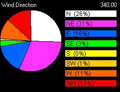
Moreover the wind direction for the past 5 days is good mostly North-North-East.
Take a look at the wind direction summary for past 5 days...

Till now there's not a bit of cloud OR cloud formation over the BAY region.
Yesterday Rain - 6.6 mm
24 Hour Rain - 27.6mm (from 12 AM - 6-Dec-07)
In the evening also it's cloudy and bit of rain around. The humidity level is also high thru the day, this is good sign for rain.
Moreover the wind direction for the past 5 days is good mostly North-North-East.
Take a look at the wind direction summary for past 5 days...

Till now there's not a bit of cloud OR cloud formation over the BAY region.
Wednesday, December 05, 2007
Climate Change Pushing Tropics Farther, Faster
December 3, 2007
Over the past 25 years the tropics have expanded by as much as 300 miles (500 kilometers) north and south—evidence of climate change in action, a new study says.
This not only means that rain-drenched regions near the Equator are growing, experts say, but also that global warming may be pushing deserts poleward in places such as the U.S. Southwest, Mexico, Australia, South Africa, South America, and the Mediterranean.
"The rate of increase is pretty big," said study lead author Dian Seidel of the National Oceanographic and Atmospheric Administration's (NOAA) Air Resources Laboratory in Silver Spring, Maryland.
"It's several degrees of latitude over the course of 25 years."
Tracking Air Circulation
If it sounds strange to think of the tropics as expanding, that's because geographers and climate scientists view them differently. To mapmakers, the tropics are simply the regions between 23.5 degrees north and south latitude, where at least once a year the sun is directly overhead.
But Seidel and her team based their definition of the tropical belt on air circulation.
Near the Equator, moist air rises, producing clouds and ideal conditions for rain forests.
That air then moves poleward—north in the Northern Hemisphere, south in the Southern Hemisphere.
Wrung dry of moisture, the air eventually descends back to Earth, producing deserts. Surface breezes then angle back toward the Equator, completing the cycle.
Seidel's team used meteorological and satellite data to find the northern and southern edges of this zone, mapping changes from the late 1970s to the present.
Within the tropics, for example, there is less stratospheric ozone—the compound that absorbs harmful UV radiation from the sun—than in the zones to the north and south.
Jet streams—fast-moving air currents traveling through Earth's atmosphere—are also influenced by the air circulation boundary between the tropics and other zones.
Also, satellites can "see" the temperature difference between cold, high-altitude cloud tops near the Equator and warmer surface lands in the cloudless dry zones to the north and south.
Seidel's team tracked changes in five measures of the tropical-subtropical air circulation boundary.
All five showed that the tropical zone was steadily broadening, at a rate of 2.5 to 4.8 degrees latitude every 25 years.
The study appears in the advance online edition of the new journal Nature Geoscience.
Faster Than Anticipated
Global climate-change models predict that the tropics will expand as Earth warms up, Seidel said, but her team's observed expansion was much faster than predicted.
"The models indicate only fractions of a degree," she said.
Seidel and colleagues aren't sure why the tropics' spread has been so much more rapid.
But she thinks it might have something to do with the stratosphere, the second layer of Earth's atmosphere, which isn't well represented in most climate models.
Because current models don't explain what's going on, it's impossible to tell whether the tropics expansion is part of a cycle that might reverse in the future or an indicator that global warming is having stronger-than-anticipated effects.
'Unpredictable Consequences'
If the trend continues, however, the impacts would extend well beyond the tropics.
That's because the shift in the Northern and Southern Hemisphere jet streams could alter the tracks of storms, such as those that hit the U.S. West Coast each winter.
"If some of that storminess moves farther north, there is potential for changes in water supply [and] snowpack—things that determine climate in mid-latitudes, where a lot of agriculture is dependent on reliable rainfall," Seidel said.
Steven Running, a professor of ecology at the University of Montana who was not involved in the study, said there could be ecological changes.
"Biogeographers define tropical ecosystems [as existing] in climate zones where it never freezes—a very fundamental biophysical threshold," Running said by email.
That keeps cold-intolerant species—such as mosquitoes—from migrating into today's temperate latitudes, he said. (Read about dengue fever's spread and its link to climate change.)
"If tropical climates move, the tropical-temperate geographic transition of ecosystems will be disrupted—with very unpredictable consequences."
Over the past 25 years the tropics have expanded by as much as 300 miles (500 kilometers) north and south—evidence of climate change in action, a new study says.
This not only means that rain-drenched regions near the Equator are growing, experts say, but also that global warming may be pushing deserts poleward in places such as the U.S. Southwest, Mexico, Australia, South Africa, South America, and the Mediterranean.
"The rate of increase is pretty big," said study lead author Dian Seidel of the National Oceanographic and Atmospheric Administration's (NOAA) Air Resources Laboratory in Silver Spring, Maryland.
"It's several degrees of latitude over the course of 25 years."
Tracking Air Circulation
If it sounds strange to think of the tropics as expanding, that's because geographers and climate scientists view them differently. To mapmakers, the tropics are simply the regions between 23.5 degrees north and south latitude, where at least once a year the sun is directly overhead.
But Seidel and her team based their definition of the tropical belt on air circulation.
Near the Equator, moist air rises, producing clouds and ideal conditions for rain forests.
That air then moves poleward—north in the Northern Hemisphere, south in the Southern Hemisphere.
Wrung dry of moisture, the air eventually descends back to Earth, producing deserts. Surface breezes then angle back toward the Equator, completing the cycle.
Seidel's team used meteorological and satellite data to find the northern and southern edges of this zone, mapping changes from the late 1970s to the present.
Within the tropics, for example, there is less stratospheric ozone—the compound that absorbs harmful UV radiation from the sun—than in the zones to the north and south.
Jet streams—fast-moving air currents traveling through Earth's atmosphere—are also influenced by the air circulation boundary between the tropics and other zones.
Also, satellites can "see" the temperature difference between cold, high-altitude cloud tops near the Equator and warmer surface lands in the cloudless dry zones to the north and south.
Seidel's team tracked changes in five measures of the tropical-subtropical air circulation boundary.
All five showed that the tropical zone was steadily broadening, at a rate of 2.5 to 4.8 degrees latitude every 25 years.
The study appears in the advance online edition of the new journal Nature Geoscience.
Faster Than Anticipated
Global climate-change models predict that the tropics will expand as Earth warms up, Seidel said, but her team's observed expansion was much faster than predicted.
"The models indicate only fractions of a degree," she said.
Seidel and colleagues aren't sure why the tropics' spread has been so much more rapid.
But she thinks it might have something to do with the stratosphere, the second layer of Earth's atmosphere, which isn't well represented in most climate models.
Because current models don't explain what's going on, it's impossible to tell whether the tropics expansion is part of a cycle that might reverse in the future or an indicator that global warming is having stronger-than-anticipated effects.
'Unpredictable Consequences'
If the trend continues, however, the impacts would extend well beyond the tropics.
That's because the shift in the Northern and Southern Hemisphere jet streams could alter the tracks of storms, such as those that hit the U.S. West Coast each winter.
"If some of that storminess moves farther north, there is potential for changes in water supply [and] snowpack—things that determine climate in mid-latitudes, where a lot of agriculture is dependent on reliable rainfall," Seidel said.
Steven Running, a professor of ecology at the University of Montana who was not involved in the study, said there could be ecological changes.
"Biogeographers define tropical ecosystems [as existing] in climate zones where it never freezes—a very fundamental biophysical threshold," Running said by email.
That keeps cold-intolerant species—such as mosquitoes—from migrating into today's temperate latitudes, he said. (Read about dengue fever's spread and its link to climate change.)
"If tropical climates move, the tropical-temperate geographic transition of ecosystems will be disrupted—with very unpredictable consequences."
2007 Hurricane Season Ending Raises Forecast Concerns
November 30, 2007
The 2007 Atlantic hurricane season, which officially ends today, has—like last year—failed to live up to the predictions of forecasters.
Now some experts fear the second year of inaccurate preseason predictions will shake the public's faith in all hurricane forecasts—even when a storm is bearing down upon them.
"I'm concerned that the public could lose confidence in the forecasting of individual storms because of the inaccuracies of long-range forecasts," said Max Mayfield, a hurricane specialist at WPLG-TV in Miami and former director of the National Hurricane Center in Miami, Florida.
Meteorologists at Colorado State University and the National Oceanic and Atmospheric Administration predicted as many as 17 named storms in the Atlantic Basin this summer.
But only 14 storms formed between June 1—the official start of the season—and today. The total does not include Tropical Storm Andrea, which formed off the coast of Georgia three weeks before the season's start.
The problem, he said, is that there is widespread public interest in the preseason hurricane forecasts.
"The most regularly asked question I had—even before, How are the wife and kids?—was, What kind of hurricane season are we going to have?" Mayfield said.
But after so many wrong calls, the public may no longer differentiate between tenuous preseason predictions and the Hurricane Center's forecasts for individual storms, he said.
Cool Explanation
The summer did produce two extremely intense hurricanes—Dean in August and Felix in September—that caused catastrophic damage in Mexico, Mayfield notes. (Read more about Hurricane Dean and Hurricane Felix.)
And conditions were ripe this year for a very active hurricane season, so it's puzzling why it fizzled out, he said.
It was especially surprising that three storms that formed at the season's peak in September—Ingrid, Jerry, and Karen—didn't develop into powerful hurricanes, he added.
Meteorologist Phil Klotzbach, who issues the Colorado State forecasts with mentor William Gray, said the lower-than-forecast storm total was caused by several factors.
These included cooler sea-surface temperatures than anticipated and upper-level winds over the Atlantic Ocean that prevented storms from intensifying.
Windblown dust from Africa may have blocked sunlight, causing the cooler ocean temperatures, he said. Tropical storms draw their strength from warm ocean waters.
Klotzbach said he and Gray will try to factor in the presence or absence of dust in their future seasonal hurricane forecasts, noting that seasonal forecasts are still an evolving science.
Reason for Thanks
Despite the inaccuracies in recent seasonal forecasts, emergency management consultants still think they are useful.
"Some people don't like them because they say it creates unnecessary hysteria," said Hans Wagner, vice president of Early Alert in Tampa, Florida. The company provides disaster management information and assistance to government agencies and private industries.
"We look at [the forecasts] as a planning tool," he said.
While the company is always on high alert during hurricane season, "when they predict an above-normal season, that always stimulates our clients to take necessary precautions and take the threat more seriously, and that helps us if they are actually threatened by a hurricane," he added.
Joe Bastardi, a meteorologist with the private weather forecasting service AccuWeather, said too much emphasis is being placed on the accuracy of preseason forecasts.
"It's almost like it's turned into theologians arguing about how many angels can fit on the head of a pin," Bastardi said.
"Overall, the nation got off very easy this year and last year.
"We are in a time until about 2020 that hurricane threats will be more frequent and more intense on our coastlines. So instead of saying, Ha, ha, ha, there's nothing going on, people should be thankful that there's not as much going on."
The 2007 Atlantic hurricane season, which officially ends today, has—like last year—failed to live up to the predictions of forecasters.
Now some experts fear the second year of inaccurate preseason predictions will shake the public's faith in all hurricane forecasts—even when a storm is bearing down upon them.
"I'm concerned that the public could lose confidence in the forecasting of individual storms because of the inaccuracies of long-range forecasts," said Max Mayfield, a hurricane specialist at WPLG-TV in Miami and former director of the National Hurricane Center in Miami, Florida.
Meteorologists at Colorado State University and the National Oceanic and Atmospheric Administration predicted as many as 17 named storms in the Atlantic Basin this summer.
But only 14 storms formed between June 1—the official start of the season—and today. The total does not include Tropical Storm Andrea, which formed off the coast of Georgia three weeks before the season's start.
The problem, he said, is that there is widespread public interest in the preseason hurricane forecasts.
"The most regularly asked question I had—even before, How are the wife and kids?—was, What kind of hurricane season are we going to have?" Mayfield said.
But after so many wrong calls, the public may no longer differentiate between tenuous preseason predictions and the Hurricane Center's forecasts for individual storms, he said.
Cool Explanation
The summer did produce two extremely intense hurricanes—Dean in August and Felix in September—that caused catastrophic damage in Mexico, Mayfield notes. (Read more about Hurricane Dean and Hurricane Felix.)
And conditions were ripe this year for a very active hurricane season, so it's puzzling why it fizzled out, he said.
It was especially surprising that three storms that formed at the season's peak in September—Ingrid, Jerry, and Karen—didn't develop into powerful hurricanes, he added.
Meteorologist Phil Klotzbach, who issues the Colorado State forecasts with mentor William Gray, said the lower-than-forecast storm total was caused by several factors.
These included cooler sea-surface temperatures than anticipated and upper-level winds over the Atlantic Ocean that prevented storms from intensifying.
Windblown dust from Africa may have blocked sunlight, causing the cooler ocean temperatures, he said. Tropical storms draw their strength from warm ocean waters.
Klotzbach said he and Gray will try to factor in the presence or absence of dust in their future seasonal hurricane forecasts, noting that seasonal forecasts are still an evolving science.
Reason for Thanks
Despite the inaccuracies in recent seasonal forecasts, emergency management consultants still think they are useful.
"Some people don't like them because they say it creates unnecessary hysteria," said Hans Wagner, vice president of Early Alert in Tampa, Florida. The company provides disaster management information and assistance to government agencies and private industries.
"We look at [the forecasts] as a planning tool," he said.
While the company is always on high alert during hurricane season, "when they predict an above-normal season, that always stimulates our clients to take necessary precautions and take the threat more seriously, and that helps us if they are actually threatened by a hurricane," he added.
Joe Bastardi, a meteorologist with the private weather forecasting service AccuWeather, said too much emphasis is being placed on the accuracy of preseason forecasts.
"It's almost like it's turned into theologians arguing about how many angels can fit on the head of a pin," Bastardi said.
"Overall, the nation got off very easy this year and last year.
"We are in a time until about 2020 that hurricane threats will be more frequent and more intense on our coastlines. So instead of saying, Ha, ha, ha, there's nothing going on, people should be thankful that there's not as much going on."

Weather CAMs live - USA
Here is a good LINK which has various links for LIVE weather cams thru out USA.
We should host some weather CAMS in India, i know it's costly, atleast we should try and host one each in 4 metros.
I hope soon my company will venture into it.
If anyone of my readers have hosted a LIVE WEB CAM in any area in INDIA, please send the link to weatherblog@gmail.com
or just post it as COMMENTS to this post.
We should host some weather CAMS in India, i know it's costly, atleast we should try and host one each in 4 metros.
I hope soon my company will venture into it.
If anyone of my readers have hosted a LIVE WEB CAM in any area in INDIA, please send the link to weatherblog@gmail.com
or just post it as COMMENTS to this post.
Mild rain continue...
Today morning (5-Dec-07) also there was a mild shower.
All Conditions are favourable for North-east monsoon to extend for another 48hrs or so.
You can take a look at the latest wind direction summary,

and the last 5 days humidity summary.

Going thru the latest satellite pic you cannot make out anything related to these showers. So good going...

All Conditions are favourable for North-east monsoon to extend for another 48hrs or so.
You can take a look at the latest wind direction summary,

and the last 5 days humidity summary.

Going thru the latest satellite pic you cannot make out anything related to these showers. So good going...

Tuesday, December 04, 2007
We are back, It's humid & rain!
We are back online after 3 days.
we were at Tirunelveli for the past 3 days...It's located down south of Tamilnadu.
There also the climate was a bit humid and some drops of rain. Nights and early morning are somewhat cold.
Now coming to chennai, On sunday the North-east current has revived slightly enough to bring some showers for the city.
This is not unusual for this time of year. The rainfall records for the past 2 days are Yesterday 12.2 mm, Today till now (10:08 AM) it's 2.6mm.
December month average is 138 mm, hoping the RAIN god to attain this atleast for the good of Chennai.
Today's wind direction is good for the rain...take a look it's mostly North-North-East.
There's nothing visible on the latest satellite pic, you can view it here
November 2007 was a disaster regarding North-East monsoon, Chennai city received only 95 MM of rain against a normal of 308 MM.
we were at Tirunelveli for the past 3 days...It's located down south of Tamilnadu.
There also the climate was a bit humid and some drops of rain. Nights and early morning are somewhat cold.
Now coming to chennai, On sunday the North-east current has revived slightly enough to bring some showers for the city.
This is not unusual for this time of year. The rainfall records for the past 2 days are Yesterday 12.2 mm, Today till now (10:08 AM) it's 2.6mm.
December month average is 138 mm, hoping the RAIN god to attain this atleast for the good of Chennai.
Today's wind direction is good for the rain...take a look it's mostly North-North-East.

There's nothing visible on the latest satellite pic, you can view it here
November 2007 was a disaster regarding North-East monsoon, Chennai city received only 95 MM of rain against a normal of 308 MM.
Subscribe to:
Posts (Atom)