This is the piece of Information i got from the IMD website about a cyclone that crossed West Bengal coast. But this was the only Cyclone to cross the West Bengal Coast in December since 1971.
December 4-11. 1981
Crossed West Bengal Coast near Sagar Island around 1300 UTC on December 10 and weakened into a depression on 11th morning over Bangladesh and into a low the same evening over Assam and Meghalaya.200 people died in 24 Parganas district of West Bengal One Million people affect in the districts of 24 Parganas.
Contributed by one of our reader:Chandramouli

Sunday, November 30, 2008
After "Nisha" - what next??
Chennai, today received some drizzles overnite.
Clear, bright and sunny morning!
Now (1:07 PM) some patches of low cloud formation can be seen, not threatening to rain.
The moisture left behind by "Nisha" and favorable wind direction (east-north-east), might trigger some thundershowers for Interior Tamilnadu.
But chennai will remain mostly clear & sunny, a possibility of some drizzles OR sharp showers late evening.
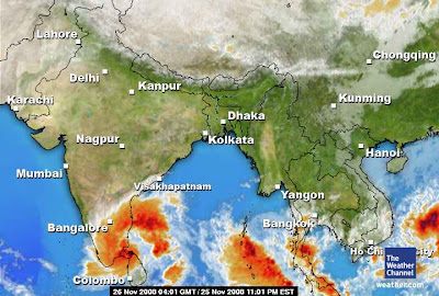
Here is the latest satellite pic...

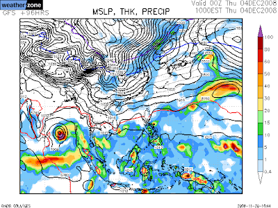
And here is the latest numeric model for the NEXT cyclone (if any..?!)
Both the models suggest there is a Depression formation around 4-Dec-08.

Clear, bright and sunny morning!
Now (1:07 PM) some patches of low cloud formation can be seen, not threatening to rain.
The moisture left behind by "Nisha" and favorable wind direction (east-north-east), might trigger some thundershowers for Interior Tamilnadu.
But chennai will remain mostly clear & sunny, a possibility of some drizzles OR sharp showers late evening.
Here is the latest satellite pic...

And here is the latest numeric model for the NEXT cyclone (if any..?!)
Both the models suggest there is a Depression formation around 4-Dec-08.


"After Nisha" - from Jim's blog, Accuweather.com
The storm is over and what lingers behind is tropical moisture that has wafted over most of peninsular India giving rise to scattered thunderstorms as of Saturday. The old low-level core of Nisha has settled as a much-weakened whirl over the eastern Arabian Sea.
The next few days of weather will lack the drama of the last week and its flooding, cyclonic rains and winds. But there will be an unusual bent to it inasmuch as tropical moisture will run unusually far northward over the western Subcontinent. The hit-or-miss showers and thunderstorms that have already arisen over Maharashtra will reach Gujarat and even southern Sindh. I would not rule out a shower at Karachi sometime within the next three to four days.
Well, there is already talk of the next depression or cyclone over the Bay of Bengal on or after the middle of next week. My take is "I do not know yet". I will wait to see consistency in numerical model runs; barring this, I will decline to forecast a Bay cyclone. Even without a well-marked tropical low, the setting does seem to favor new outbreaks of rain, but nothing like the one now ended.
--The rain unleashed by the big, lumbering weather system the became Tropical Cyclone Nisha has triggered tragic flooding. The statistics themselves were staggering. The storm's four-day outburst of rain poured 57.9 cm/22.8 inches upon Chennai-Minambakkam. And rains ahead of Nisha swelled the amount to 59.6 cm/26.6 inches, or more than two fold the normal monthly rainfall--all of this within about one week. And, by my reckoning, rainfall at Cuddalore since last Friday has reached 33 inches (about 84 cm), give or take.
Saturday, November 29, 2008
The last of "NISHA" - Chennai: 28CM rainfall
Chennai Airport received 28cm of extreme heavy rainfall till 8:30AM, 28-Nov-08.
Now "Nisha" is just a LOW pressure and dissipating fast over south-interior Andhra & parts of East-Karnataka.
It was pouring over those area, yesterday (29-Nov-08).
CHENNAI:
Water logging in draining slowly.
We are receiving some intermittent showers from Yesterday morning.
Evening it was heavy.
Today morning also it was heavy.
Now (2:15PM) also we had a sharp shower.
Still the Cloud movement is from south-east, as long as this does'nt change we'll continue to receive more rains.
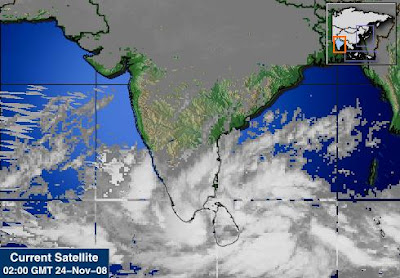
Latest satellite pic...

We are tracking a Numeric model for another Cyclone over the south-bay.

Now "Nisha" is just a LOW pressure and dissipating fast over south-interior Andhra & parts of East-Karnataka.
It was pouring over those area, yesterday (29-Nov-08).
CHENNAI:
Water logging in draining slowly.
We are receiving some intermittent showers from Yesterday morning.
Evening it was heavy.
Today morning also it was heavy.
Now (2:15PM) also we had a sharp shower.
Still the Cloud movement is from south-east, as long as this does'nt change we'll continue to receive more rains.
Latest satellite pic...

We are tracking a Numeric model for another Cyclone over the south-bay.

Friday, November 28, 2008

Something about "NISHA" from Jim's blog
Something about "NISHA" from Jim's blog, www.accuweather.com
Thanks to some "fancy footwork", the center of Tropical Cyclone Nisha held offshore for something like another 10 or 12 hours following its earlier purported landfall. While satellite imagery seemed to confirm the earlier time, surface winds and pressure field belied it. I note here that slowly moving tropical cyclones will often tend to keep a center over water until the whole mass is committed to shift inland.
Anyways, there is no doubt that, as of 1800 UTC, Thursday, the center of Nisha is inland and dissipating. Wind and tide are thus no longer a big factor; however, satellite imagery makes it clear that torrential downpours are still taking place. One has poured 10 cm of rain upon Cuddalore within three hours. This hikes to 68 cm/26.8 inches the rainfall here since late last week (5 to 6 days).
Readers may wish to browse comments from the foregoing post. Here is one segment relating to torrential rain and widespread severe flooding:
"The following stations recorded extremely heavy rainfall in centimetres:
Orathanadu (Thanjavur dt) 66, Thanjavur 53, Vedaranyam 42, Adiramapattinam 33, Muthupet (Tiruvarur dt) 30 and Kumbakonam (Thanjavur dt) 26."
I have never seen a 24-hr rainfall total of 66 cm anywhere in Tamil Nadu. Simply unbelievable. Chennai's 24-hr rainfall was 14 cm. Needless to say, widespread flooding and devastation of winter crops, especially in the Thanjavur-Thiruvarur-Nagapattinam belt (the so-called 'rice bowl' of South India), off where the storm hovered for 2 days before landfall.
Looking forward, the old core of Nisha will drift northwest during the next few days, which means it will leave land for the eastern Arabian Sea. Showers and downpours will fade over coastal southeast India even as the leading edge of showers and thunderstorms shifts north and west to Karnataka and Maharashtra. There is even the believable scenario of scattered showers and thunderstorms reaching Gujarat and southermost Sindh, Pakistan.
One thing to raise before leaving South Asia: strong north-south pressure gradient will stir up strong easterly winds along and right down wind of the crest of the Western Ghats in Maharashtra and Karnataka through Friday night, local time.
Oh, and still another thing. Recall that, as of the start of the week, I was speaking about another tropical cyclone "threat". Well, I will now say the we have had the cyclone--in the shape of TC Nisha, which proved to "steal the show".
-----------------------------------------------
Well, not only did Tuesday's tropical depression get upgraded to tropical cyclone, it became a rather strong tropical storm before its landfall upon southeastern India between 0600 UTC and 1200 UTC, Wednesday. Shortly before landfall, Tropical Cyclone Nisha was reckoned, by the JTWC, to have highest sustained winds of 55 knots/100 km/h. Landfall happened over the state of Tamil Nadu between Karaikal (Puducherry) and Vedaranniyam. Thus, the time between upgrade over northern Sri Lanka and landfall in India was between 12 and 18 hours.
While there potentially damaging winds near the landfall of Nisha (gales observed at Karaikal as of 0900 UTC), the storm, both before and after its upgrade, was, foremost of all, a rainmaker. In northern Sri Lanka, a report of about 24 inches/60 cm of rain within two to three days at Jaffna seems believable. In southeast India, where the North East Monsoon has been stirring up local heavy rain for several days, rainfall has reached at least 21.9 inches/55.6 cm at Cuddalore, Tamil Nadu, and 16.4 inches/41.7 at Karaikal, Puducherry, as of 1800 UTC--and still falling. This is serious flooding rainfall. And at Chennai, rainfall since late last week is at least 10.5 inches/26.7 cm. For Chennai, this brings November rainfall to near normal.
Nisha will dissipate within about 24 hours over the southern Deccan of India. But there will be showers and thunderstorms with local heavy falls over Tamil Nadu and Andhra Pradesh with significant, if spotty, rain into Kerala and Karnataka. And, if the latest (1200 UTC, Wednesday) GFS forecast scenario hold true, this weekend into early next week will see scattered showers and thunderstorms spreading not only over western Maharashtra, but into Gujarat and even southern Sindh, Pakistan.


"Nisha" tiring & Chennai flooded
"Nisha's" cloud mass crossed over Chennai before moving into South-Andhra.
Now(12:30PM) the cloud mass is in South-Andhra.
See for urself...

Chennai received around 50 CM in last 4 days...
City infrastructure does not support this kind of bursts.
We received abnormally heavy showers thru the day yesterday (27-Nov-08) and night till Early morning of 28-Nov-08.
After that we had SUN for a while, then we are experiencing some mild showers.
All roads are like RIVERS and LAKES.
These mild showers are making it even more worse.
Chennai was receiving showers from East-south-east yesterday , now receiving from South-south-east.
Most parts of CHENNAI are still without electricity.
We are expecting more disaster videos & Photos to pop up in YOUTUBE & FLICKR.
Meanwhile numeric models show a NEW cyclone around 2-Dec-08.

Thursday, November 27, 2008
"Nisha" - Erratic and Raging
Nisha's path is quiet erratic.
Now it's very near to Karaikal... this time it'll make landfall.
Chennai is receiving very heavy rains.. thru the night,morning and now (9:51AM).
There's water ..water .. everywhere!
Here's the latest satellite pic from BBC

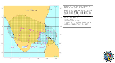
and here's the latest JTWC tracking.

Here are some rainfall details recorded at 8:30 AM, 26-Nov-08.
Orathanadu (Thanjavur dt) and Vedaranyam 33 each, Parangipettai and Chidambaram (Cuddalore dt) 28, Thiruvidaimaruthur (Thanjavur dt) and Mayiladuthurai (Nagapattinam dt) 26 each and Sirkali (Nagapattinam dt) 25.
Now the numeric models show that less chance of that December-1st week cyclone..

Now it's very near to Karaikal... this time it'll make landfall.
Chennai is receiving very heavy rains.. thru the night,morning and now (9:51AM).
There's water ..water .. everywhere!
Here's the latest satellite pic from BBC

and here's the latest JTWC tracking.

Here are some rainfall details recorded at 8:30 AM, 26-Nov-08.
Orathanadu (Thanjavur dt) and Vedaranyam 33 each, Parangipettai and Chidambaram (Cuddalore dt) 28, Thiruvidaimaruthur (Thanjavur dt) and Mayiladuthurai (Nagapattinam dt) 26 each and Sirkali (Nagapattinam dt) 25.
Now the numeric models show that less chance of that December-1st week cyclone..

Wednesday, November 26, 2008
"Nisha" - No landfall yet

No landfall yet... still travelling slowly along & close to coast.
Slowly moving north-north-west.
It's expected to make landfall SOON.
Chennai is receiving intermittent Sharp heavy showers with gusts from morning.
Still continues...

"06B - Nisha" - raging along the central coast of Tamilnadu
Whole of Tamilnadu is under "06B".
Here are some rainfall data recorded till 8:30 AM, 25-Nov-08
Thiruvidaimaruthur (Thanjavur dt) 30 and Thanjavur and Mandapam (Ramanathapuram dt) 25 each.Rameswaram 23, Orathanadu (Thanjavur dt) 19, Mayiladuthurai 17, Eachanvidhi (Thanjavur dt) 16, Thirukattupalli, Ayyampettai (Both Thanjavur dt), Viralimalai (Pudukottai dt), Thangachimadam (Ramanathapuram dt), Pamban and Tirumanur (Ariyalur dt) 15 each, Thiruvaiyaru (Thanjavur dt) and Pullambadi (Thiruchirapalli dt) 14 each, Annamalai Nagar and Lalpet (both Cuddalore dt), Valangaiman (Thanjavur dt), Kollidam and Sirkali (both Nagapattinam dt) 13 each, Papanasam (Thanjavur dt) and Ramanathapuram 12 each, Kumbakonam and Budalur (both Thanjavur dt),Kattumannarkoil(Cuddalore dt),Kodavasal (Tiruvarur dt),Udayalpatti and Kattumavadi (both Pudukottai dt) and Kallakudi (Thiruchirapalli dt) 11 each, Grand Anaicut, Kurungalam, Lower Anaicut and Manjalar (all Thanjavur dt), Chidambaram and Sethiyathope (both Cuddalore dt), Manalmedu(Nagapattinam dt), Karaiyur Pudukottai dt), Manamelkudi and Aruppukottai 10 each
Chennai is getting heavy rains from this system.
We are getting rain from 4:30PM, 25-Nov-08 to till now.
SOme drizzle gaps inbetween.
Now (10:06AM, 26-Nov-08) also it's raining.
And more to come till early evening.
Satellite pic & JTWC tracking...
Suggests that, "06B" will make landfall in 1 or 2hrs time.
It's almost there, Making landfall near Rameswaram & Nagapatinum.
The remnense of this system will give more rains for atleast another 48 HRS, thruout North-Tamilnadu & Interior.
We are constantly tracking a GFS model suggesting a Super Cyclone at the END of this month.

Here are some rainfall data recorded till 8:30 AM, 25-Nov-08
Thiruvidaimaruthur (Thanjavur dt) 30 and Thanjavur and Mandapam (Ramanathapuram dt) 25 each.Rameswaram 23, Orathanadu (Thanjavur dt) 19, Mayiladuthurai 17, Eachanvidhi (Thanjavur dt) 16, Thirukattupalli, Ayyampettai (Both Thanjavur dt), Viralimalai (Pudukottai dt), Thangachimadam (Ramanathapuram dt), Pamban and Tirumanur (Ariyalur dt) 15 each, Thiruvaiyaru (Thanjavur dt) and Pullambadi (Thiruchirapalli dt) 14 each, Annamalai Nagar and Lalpet (both Cuddalore dt), Valangaiman (Thanjavur dt), Kollidam and Sirkali (both Nagapattinam dt) 13 each, Papanasam (Thanjavur dt) and Ramanathapuram 12 each, Kumbakonam and Budalur (both Thanjavur dt),Kattumannarkoil(Cuddalore dt),Kodavasal (Tiruvarur dt),Udayalpatti and Kattumavadi (both Pudukottai dt) and Kallakudi (Thiruchirapalli dt) 11 each, Grand Anaicut, Kurungalam, Lower Anaicut and Manjalar (all Thanjavur dt), Chidambaram and Sethiyathope (both Cuddalore dt), Manalmedu(Nagapattinam dt), Karaiyur Pudukottai dt), Manamelkudi and Aruppukottai 10 each
Chennai is getting heavy rains from this system.
We are getting rain from 4:30PM, 25-Nov-08 to till now.
SOme drizzle gaps inbetween.
Now (10:06AM, 26-Nov-08) also it's raining.
And more to come till early evening.
Satellite pic & JTWC tracking...


Suggests that, "06B" will make landfall in 1 or 2hrs time.
It's almost there, Making landfall near Rameswaram & Nagapatinum.
The remnense of this system will give more rains for atleast another 48 HRS, thruout North-Tamilnadu & Interior.
We are constantly tracking a GFS model suggesting a Super Cyclone at the END of this month.

Tuesday, November 25, 2008
"93B" - all of a sudden


We are tracking a tropical depression... and got lot of potential to become as a low power cyclone.
Now it's not moving anywhere.
Chennai is receiving a typical depression/cyclone style rainfall..
starting with very mild drizzle, then heavy drizzle, shower, heavy and it goes on..
Now we are in "shower" mode... it'll go on thru the night.
This system is now south-east of Chennai, and close to land.
It might move a bit north and then north-west.
It'll make landfall before NOON tomorrow (26-Nov-08).
** Enjoy the showery/heavy shower night ahead **
FNMOC - numeric models
Please check this site for latest FNMOC - WXMAP - Numeric Models
And
EFS PRECIPITATION Probability displays
And
EFS PRECIPITATION Probability displays
THANKS
Thanks for all views and posts.
We are taking steps to HOST a website for "Indian weather, environment, pollution & more..."
We'll get back on this project soon.
Please try to promote this website (blog) among your friends.
We are taking steps to HOST a website for "Indian weather, environment, pollution & more..."
We'll get back on this project soon.
Please try to promote this website (blog) among your friends.
Full of tamilnadu is wet.
Almost FULL of tamilnadu is wet, yesterday and it's continuing today also.
Here are some rainfall stats::
Parangipettai and Thozhudur (Cuddalore dt) 15 each, Sethiathope, Virudhachalam, Bhuvanagiri and Kuppanatham (all Cuddalore dt), Kallakurichi (Villupuram dt) 13 each, Kothavacherry, Kattumailur and Memathur (all Cuddalore dt) and Kilacheruvai 12 each, Annamalainagar and Vepur (all Cuddalore dt), Lower Anaicut (Thanjavur dt), Manalmedu, Sirkali and Mayiladuthurai (all Nagapattinam dt) and Ramanathapuram 11 each, Chidambaram (Cuddalore dt), Kattumavadi (Pudukottai dt), Pallamorkulam and Rameshwaram (both Ramanathapuram dt) and Ariyalur 10 each, Cuddalore, Pallandurai, Lakkur, Vanamadevi and Lalpet (all Cuddalore dt), Puducherry Airport, Adiramapattinam, Thiruvidaimaruthur (Thanjavur dt), Muthupet and Valangaiman (both Tiruvarur dt), Kollidam (Nagapattinam dt), Mimisal and Viralimalai (both Pudukottai dt) Attur (Salem dt) and Jayamkondam (Perambalur dt) 9 each, Panruti (Cuddalore dt), Thanjavur, Kumbakonam (Thanjavur dt), Manamelkudi, R.S. Mangalam (Ramanathapuram dt), Tondi, Ayikudi (Tirunelveli dt) and Thirumanur (Perambalur dt) 8 each and Kattumannarkoil (Cuddalore dt), Villupuram, Karaikal, Ayyampettai, Manjalaru, Papanasam and Tirukattupalli (all Thanjavur dt), Thiruthuraipoondi (Tiruvarur dt), Ayinkudi, Avudayarkoil and Nagudi (all Pudukottai dt), Thammampatti (Salem dt), Vattanam (Ramanathapuram dt), Kayalpattinam and Maniyatchi (both Tuticorin dt) and Aruppukottai 7 each.
More & more cloud formation can be seen over south-west & south-central Bay.
There are more chances now for a Swirl/Depression near North-East of Srilanka.
Here is the latest numeric prediction...we'll keep updated.

In Chennai:
Yesterday, it was calm thru the day.
Slight drizzles in the evening.
In the early morning (25-Nov-08), we had some sun shine after 3 days.
Now (12:09PM) a high cloud base has moved in from Sea.
Medium low cloud formations can be seen... more likely we'll receive a sharp shower or two in evening.
Also we are experiencing some wind gusts.
Monday, November 24, 2008
More to come...
From friday evening... we are experiencing FULLY cloudy conditions with shower bursts inbetween.
Saturday full day we had drizzles. Almost non-stop.
And saturday night and thru to sunday morning we had short showers.
On Sunday morning there was a lull, but with lots of cloud formations around.
At around 12pm we had a super shower with lightning.
After that a lull then at around 9:30 PM we had another super shower this time with squally winds.
THe north-east monsoon is in full swing over tamilnadu.
The rains are widespread.
Rameshwaram (Ramanathapuram dt) recorded a heavy rainfall of 7 centimetres (till sunday 8:30 AM)
And Chennai recorded 3cm.
Going by latest satellite pic and LONG range numeric model...
More rain to come.
Lot's of moisture in south-bay.
More cloud activity can be seen.
And importantly a long range model shows a SUPER cyclone near tamilnadu or south-central bay.
2 models from 2 different website state the same thing.. take a look.
Soon we can see a swirl in BAY.


Saturday full day we had drizzles. Almost non-stop.
And saturday night and thru to sunday morning we had short showers.
On Sunday morning there was a lull, but with lots of cloud formations around.
At around 12pm we had a super shower with lightning.
After that a lull then at around 9:30 PM we had another super shower this time with squally winds.
THe north-east monsoon is in full swing over tamilnadu.
The rains are widespread.
Rameshwaram (Ramanathapuram dt) recorded a heavy rainfall of 7 centimetres (till sunday 8:30 AM)
And Chennai recorded 3cm.
Going by latest satellite pic and LONG range numeric model...

More rain to come.
Lot's of moisture in south-bay.
More cloud activity can be seen.
And importantly a long range model shows a SUPER cyclone near tamilnadu or south-central bay.
2 models from 2 different website state the same thing.. take a look.
Soon we can see a swirl in BAY.


Saturday, November 22, 2008
After a long wait...
Going by previous MJO forecast, from 22-Nov-08 we'll move into a WET phase.
It's perfect it seems.
Chennai and almost all parts of Tamilnadu are receiving heavy rainfall from yesterday afternoon.
Chennai got it's first burst after a long wait... at around 5 PM..It was heavy.
Thru the night it rained as short bursts and in early morning of 22-Nov-08, we had another heavy rain.
Now it's cloudy and drizzling heavy.
Going by latest satellite pic and numeric forecast.


We can see lots of cloud cover, going to be a wet weekend and upto mid of next week.
And the GFS suggests a depression forming near north-east of srilanka in next 36 hrs.
Expect more from it..
Chennai received 59.2 mm in last 24 hrs.
Here are some rainfall details
Muthupet (Tiruvarur dt) recorded a heavy rainfall of 8 centimetres
Adiramapattinam, Rameswaram (Ramanathapuram dt), Ambasamudram (Tirunelveli dt), and Aruppukottai (Virudhunagar dt) 6 each, Tondi, Tiruvadanai (Ramanathapuram dt), Manimutharu (Tirunelveli dt), Palayamkottai, Maniyatchi (Tuticorin dt), Tiruchuzhi (Virudhunagar dt), Mancompu (Alapuzha dt) and Kottayam 5 each, Nanguneri, Tirunelveli, Sivagiri (Tirunelveli dt) and Minicoy 4 each, Pamban, Peravurani (Thanjavur dt), Karambakudi (Pudukottai dt), Pudukottai, Mudukulathur and R. S. Mangalam (both Ramanathapuram dt), Papanasam (Tirunelveli dt), Ottapidaram, Srivaikundam and Tiruchendur (all Tuticorin dt) , Tirupathur (Sivaganga dt) and Kozhikode Airport 3 each, Orathanadu, Pattukottai and Tiruvaiyaru (all Thanjavur dt), Thanjavur, Mannargudi and Thiruthuraipoondi (both Tiruvarur dt), Arantangi, Illupur and Tirumayam (all Pudukottai dt), Ramanathapuram, Sankarankoil (Tirunelveli dt), Sathankulam (Tuticorin dt), Tuticorin, Ilayankudi, Karaikudi and Manamadurai (all Sivagangai dt), Sattur, Sivakasi and Watrap (all Virudhunagar dt) 2 each and Kanyakumari, Coimbatore Airport, Sankarapuram (Villupuram dt), Kumbakonam (Thanjavur dt), Kodavasal, Nannilam and Valangaiman (all Tiruvarur dt), Tiruvarur, Alangudi (Pudukottai dt), Kadaladi, Kamudhi and Paramakudi (all Ramanathapuram dt), Tenkasi (Tirunelveli dt), Surangudi and Vilathikulam (both Tuticorin dt), Thovalai, Mylaudy and Pechiparai (all Kanyakumari dt), Kanyakumari, Tiruppur(Coimbatore dt), Mayanur (Karur dt), Vembavur (Perambalur dt), Marungapuri, Thathaiyangarpet and Thuraiyur (all Tiruchirapalli dt), Melur and Mettupatti (both Madurai dt), Sivagangai and Tirupuvanam (both Sivagangai dt), Natham (Dindigul dt), Alapuzha, Agathi and Thiruvananthapuram city 1cm each.
Friday, November 21, 2008
Another disapointing day (20-Nov-08)
A humid morning (20-Nov-08) with lot's of cloud formations.
Even some clouds dissipated after crossing main land chennai... and towards west-north-west.
A low pressure trough near srilanka has brought more rains to south & south-south tamilnadu. Even nilgiris is receiving more rain.
Look at this rainfall readings..(8:30 AM, 20-Nov-08)
Vedaranyam recorded a heavy rainfall of 7 centimetres, Vanur (Villupuram dt) and Sirkali (Nagapattinam dt) 6 each, Villupuram, Lower Anaicut (Thanjavur dt), Tirupoondi, Tarangambadi, Manalmedu and Kollidam (all Nagapattinam dt), Karaikal 5 each, Kattumannarkoil (Cuddalore dt), Parangipettai, Nannilam, Thiruthuraipoondi and Valangaiman (all Tiruvarur dt), Talaignayar and Mayiladuthurai (both Nagapattinam dt), Kattumavadi and Karambakudi (both Pudukottai dt), Thangachimadam (Ramanathapuram dt) and Polur (Thiruvannamalai dt) 4 each, Cuddalore, Thozhudur, Panruti, Kothavacherry, Lalpet, Annamalainagar and Bhuvanagiri (all Cuddalore dt), Tirukoilur (Villupuram dt), Puducherry Airport, Manjalaru and Pattukottai (both Thanjavur dt). Kodavasal and Muthupet (both Tiruvarur dt), Tiruvarur, Nagapattinam, Mimisal, Illupur and Perungalur (all Pudukottai dt), Barur (Krishnagiri dt), Sendurai, Taluthalai and Jayamkondam (all Perambalur dt), Devimangalam, Navalur Kottapattu and Marungapuri (all Tiruchirapalli dt) 3 each
Even Maduranthagam has got 2 cm of rain.
Unfortunately we did not get anything.
This bad run of "NO rains" will bring drought like conditions very early into coming summer.
Today (21-Nov-08) going by satellite pic...

WE can see NO traces of yesterday's Low pressure trough.
Here the cloud formations has gone down.
And worst part is we had a cold morning with DEW drops on leaves.
Now (9:31 AM) it's partly cloudy and no sign of rain..
Going to be a dry day.
Wednesday, November 19, 2008
Some advice from Jim's blog in Accuweather.com
Maybe it is not where one might have thought as of Monday: however, there may be a tropical cyclone gathering south of the Equator. The JTWC have advised that such may happen over open seas southwest of Sumatra. There is another "whirl" opposite the Equator from southern India and Sri Lanka. It is not as near to tropical depression status as the tropical low to its east.
As for any "ghost" of Tropical Storm Noul, now dissipated over southern Thailand, I see no indication, based upon numerical forecast scenarios, of its regeneration into a tropical depression (let alone tropical cyclone) westward over the Andaman Sea and southern Bay of Bengal.
Tropical moisture wafted over the southern half of India has fostered a few widely-separated thunderstorms on Tuesday. This moisture will bring hit-or-miss thunderstorms over southern and eastern India for another two days or so, bolstered in part by a "Western Disturbance" sweeping eastward over Pakistan and northern India within a well-marked sub-tropical jet stream.
At the weekend and the start of next week, showers and thunderstorms having the "earmarks" of the North East Monsoon are indicated once again by the latest GFS scenarios.
Small shower and what more...
Yesterday (18-Nov-08) evening around 5:45PM we had a sharp shower. In some places of Chennai (South-south-east) had experienced even electric shower.
After that the night was mild with moist winds from east-north-east.
Going by latest satellite pic...

A good cloud formation can be seen over North srilanka sea.
This might evolve into a LOW pressure trough along the north-tamilnadu coast.
And it'll prevail there for another 3 days.
This will bring us more rains in coming 48 hrs.
More rains over south-south-tamilnadu..and scattered rain over north tamilnadu.
Thriuvanathapuram 5, Kavali 4, Tirukoilur (Villupuram dt) and Kuzithurai (Kanyakumari dt) 3 each, Ambur (Vellore dt).
Tuesday, November 18, 2008
Great morning
Great warm, humid and bright morning.
Deep blue skies. It means we can expect a NEW weather front to move in OR the OLD weather front has cleared.
Mostly Deep blue skies mean more rain on the way..!!
Good eastern air current.
Lot's of heavy cloud movement from east.
Lot's of Electric cloud formation can be seen over the Sea to the east. This means there's something out there.
We can expect the showers to break out after today evening.
South-south tamilnadu (kanyamumari district) is still experiencing Afternoon rains almost daily.
Update regarding the Depression "Noul" over vietnam..:
The system has almost dissipated completely.
JTWC has also given up tracking the system.

Going by the latest satellite pic..
We can see lots of activities over the MARKED area on the satellite image. We'll keep an eye on that area.

Sunday, November 16, 2008
SUGGESTION
Thanks for all the visits & comments.
In fact each comment by itself is an article in nature.
One suggestion from me:
Shall WE start a common HOSTED website (blog kind) for "India weather, climate, environment...".
In that WE can allow each APPROVED & REGISTERED members to post articles.
If YOU are interested in joining ME with this venture pls mail me at
freedownloadshop@gmail.com
Regional IMD weather report
Checkout latest IMD regional weather report ...
http://education.vsnl.com/imdchennai/rdwr.htm
http://education.vsnl.com/imdchennai/rdwr.htm
Another depression soon...
According to latest JWTC tracking of another depression near Vietnam.
See for urself...

See for urself...

"05B - Khai-muk" - Final

WE(Chennai) missed the Minor-cyclone's action.
It moved thru South-Andhra and it was quiet a big cloud mass yesterday evening.
Even we were in its southern band.
That's why we got a typical depression style rainfall yesterday(15-Nov-08, 5PM) evening(starting with mild drizzle & then slightly heavy).
The heavy drizzle continued till 3 AM in the morning.

Now the depression is dissipating fast.
And it's remnence can be seen over interior-karnataka.
We received around 15.2 mm of rain.
Today (16-Nov-08,12:49PM) it's clear and with patchy clouds around.
Humidity is little bit high.
For next 48 hrs we can expect clear skies with some passing showers after Today.
Friday, November 14, 2008
Latest on "05B" - No name yet
According to me it's moving north and slightly weak at this stage...
IMD's story:
********************************************
A depression over southeast and adjoining south west Bay of Bengal and lay centred at 1730 hours IST of yesterday, the 13th November 2008 near lat.11.5° N and long. 85.5° E, about 600 kms east-southeast of Chennai. It then moved northwestwards, intensified into a deep depression and lay centred at 0830 hours IST of today, the 14th November 2008, near lat. 12.5 N and Long. 85.0 E about 520 km east-southeast of Chennai and 600 km southeast of Machlipatanam. The system is likely to intensify into a cyclonic storm and move in a northwesterly direction towards coastal Andhra Pradesh. Under its influence, rainfall at most places with isolated heavy to very heavy falls is likely over coastal Andhra Pradesh and adjoining areas of Tamil Nadu during next 48 hours commencing from today, the 14th November 2008 afternoon.
********************************************
Latest JWTC projection and satellite pic...
********************************************


********************************************
REQUEST
If anyone reading/following this blog from South-Andhra or Chennai.
Please try to take "SNAPS" or "VIDEO" of the impact of CYCLONE and post it in FLICKR or YOUTUBE or Mail it to "freedownloadshop@gmail.com"
Dont' forget to send us the LINK, we'll publish it here.!
Thanks
ADMIN
Please try to take "SNAPS" or "VIDEO" of the impact of CYCLONE and post it in FLICKR or YOUTUBE or Mail it to "freedownloadshop@gmail.com"
Dont' forget to send us the LINK, we'll publish it here.!
Thanks
ADMIN
Cyclone "05B"... now a cyclone
Still it's not Named, Anyway it's "05B".
Look at the latest projection by JWTC...
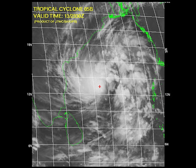

It's destined to HIT South-Andhra. This is happenning after almost 2 years (according to my memory, I'll clarify on this later)
Chennai lies in a least danger zone.
Sky is cloudy and will be cloudy.
Typical sky before a Cyclone.
If the cyclone gathers speed and moves as it is now... then we can expect light showers from Today evening.
Some text from JWTC:
************************************
AT 140000Z TROPICAL STORM (TS) 05B WAS LOCATED NEAR 12.9N
84.8E, APPROXIMATELY 265 NM EAST OF MADRAS, INDIA, AND HAD TRACKED NORTH-
WESTWARD AT 05 KNOTS OVER THE PAST SIX HOURS. MAXIMUM SUSTAINED SURFACE
WINDS WERE ESTIMATED AT 35 KNOTS GUSTING TO 45 KNOTS. SEE REF A (WTIO31
PGTW 140300) FOR FURTHER DETAILS
************************************
Thursday, November 13, 2008
Cyclonic formation "91 B"
Yesteday we did not get any rains till today (13-Nov-08) morning.
Now (12:03 PM) we are experiencing some drizzles & a passing shower.
But good thing is it's heavily cloudy and with good rain bearing clouds forming all over North, north-east and East.
This might be the signs of things to come, because we are tracking a Fairly potential Tropical depression/Cyclone... almost parallel to Chennai.
Here is the latest tracking info from www.nrlmry.navy.mil
********************************************
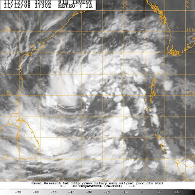
THE AREA OF CONVECTION PREVIOUSLY LOCATED NEAR 10.2N 89.6E
IS NOW LOCATED NEAR 11.8N 87.5E, APPROXIMATELY 430 NM EAST OF MADRAS,
INDIA. RECENT ANIMATED INFRARED SATELLITE IMAGERY SHOWS DEEP CON-
VECTION, THAT WAS PREVIOUSLY CONFINED TO THE THE PERIPHERIES OF THE
CIRCULATION, DEVELOPING NEAR THE CENTER OF THE SLOWLY CONSOLIDATING
LOW LEVEL CIRCULATION CENTER (LLCC). THIS LLCC IS ALSO EVIDENT IN A
121105Z SSMI IMAGE. THIS DISTURBANCE LIES NEAR AN UPPER-LEVEL ANTI-
CYCLONE AXIS, IN AN AREA OF LOW TO MODERATE VERTICAL WIND SHEAR AND
FAVORABLE POLEWARD DIFFLUENCE ALOFT. MAXIMUM SUSTAINED SURFACE WINDS
ARE ESTIMATED AT 20 TO 25 KNOTS. MINIMUM SEA LEVEL PRESSURE IS EST-
IMATED TO BE NEAR 1003 MB. DUE TO THE CONSOLIDATING DEEP CONVECTION,
THE POTENTIAL FOR THE DEVELOPMENT OF A SIGNIFICANT TROPICAL CYCLONE
IN THE NEXT 24 HOURS IS UPGRADED TO FAIR.********************************************
More abt this from Jim's Accuweather.com Blog...
*********************************************
The broad mass of showers and thunderstorms is loosely organized, but shows good outflow aloft--this is essential to "close the loop" (inflow, rising, condensation and energy release, outflow, sinking) that is exhibited by any tropical storm.
My (learned?) guess is that a tropical cyclone will arise from this mass. Andhra Pradesh and northern Tamil Nadu would be the likely targets for the center of whatever becomes of this entity.
Beyond the question of cyclone/no cyclone, there is the problem of upcoming rainfall (it would be deemed "North East Monsoon" rain) over the south of India (and Sri Lanka). There is going to be some, and there will be locally heavy rain (scattered if no cyclone, focus near landfall if a cyclone).
An aspect of the upcoming rains in southern India has arisen that I had not earlier foreseen. This would be an outbreak of thunderstorms along the west coast and Western Ghats northward to at least greater Mumbai during the first part of next week. A vigorous short wave trough in the Westerlies (Western Disturbance), swinging east from the Khaleej by way of Iran, would play a part in this scenario, were it to happen.
*********************************************
Wednesday, November 12, 2008
Some info from Accuweather - Blog
*******************************************
As the week gets into full swing, it is a good time to pause and assess what is happening, broadly, over the northern Indian Ocean region. The roughly last two weeks have seen exceptionally dry weather, not only where it is usually dry at midfall, but also where it should be raining; namely, the southeast of India.
November is the time of the North East Monsoon, which is really the return of Trade Winds to the Bay of Bengal in answer to the southward shift of the Inter Tropical Convergence. Where northeasterlies blow on shore and up slope (southern east India to Sri Lanka) they bring rain whilst the ITCZ is still significantly north of the Equator. The rains later yield to winter's drought.
So it is an abnormally strong anticyclone aloft, settled as it was over the northern Arabian and the western subcontinent, that shut off the NE Monsoon rains as the four week of October got underway. Only as of this early week are there even a few scattered downpours over southernmost India. But some changes have begun; so, where will this lead?
Satellite imagery shows the scattered deep convection (namely, thunderstorms) has spread westward into the southern half of the Bay of Bengal along with some kind of broad, ill-defined tropical entity. It is this weather system that numerical models have been keying on for something like the last week. However, attempts to spin up a tropical cyclone of it have been no more than numerical fantasy, at least thus far, and the forecast scenarios of the last few days have steered away from any well-marked low (cyclone or depression).
Instead, it looks now like broad, shallow low pressure will tend westward and west- northwestward over the Bay with deep convective rains reaching Sri Lanka as well as Tamil Nadu to southern Andhra Pradesh. Maybe, scattered storms will erupt near the sea northeastward to Orissa.
Were a well-marked low to spin up over the Bay, rather than a broad, shallow and ill-defined low, southern India may end up mostly dry, at least away from the track of the would-be low.
*******************************************
lull.. and what next?


On 10-Nov-2008, there was some rain bursts after a 2 week lull.
Yesterday (11-Nov-2008) again there was lull. In fact there was almost no sign of rain till midnight.
Early morning today (12-Nov-2008, 6 AM) there was some heavy drizzles around.
Now (9:21 AM) it's cloudy, humid, no low cloud movement yet and bad scene is the wind is from west-north-west.
After going thru latest satellite pic and 2 day numeric forecast.
We can say that the RAIN is coming.
It seems to be, there is a LOW formation over the North srilanka.
And this LOW may become into a Depression OR just a Low pressure trough system and move north. If this happens then we'll surely in for more heavy rains in next 36 hrs.
Monday, November 10, 2008
Started again after 2 weeks of lull
Early morning "No chills" and "Clouds moving in from East".
After that around 8:00 AM the sky was deep-blue in color... that itself is an indicator of new weatherfront moving in.
Around 7:30 AM there was some passing drizzles around north-Chennai.
Heavy cloud formations can be seen over the East and above the sea..
At about 1:30 PM the sky broke open..a small sharp shower lasted for 20 min.
Initially the showers will be of light intensity... then it'll get heavier after evening.
There's more rain to come.
Meanwhile we'll keep track on the cloud formations over the Bay near Srilanka.
This might become a Depression in next 24 hrs.
Sunday, November 09, 2008
Some more other blogs
Jim's Blog in Accuweather.com
***********************************
Return, indeed. There have been indicators hinting of a return to rain over southern India, where rains of the North East Monsoon should be near their height. But a strong anticyclone aloft over the western Subcontinent and the northern Arabian Sea has all but locked out the rain. We have seen scattered rains in the far south as of Saturday.
The strong upper-atmospheric anticyclone will break down during the next three to five days. This alone would be a good thing, but there may be a new twist. Latest GFS scenarios have a tropical cyclone over the Bay of Bengal north of the 15th parallel as of the middle of next week. At latitude lower than 15 degrees North (yes, this would be Tamil Nadu along with southern Andhra Pradesh), such place bodes ill for a widespread rain outbreak
***********************************
***********************************
Return, indeed. There have been indicators hinting of a return to rain over southern India, where rains of the North East Monsoon should be near their height. But a strong anticyclone aloft over the western Subcontinent and the northern Arabian Sea has all but locked out the rain. We have seen scattered rains in the far south as of Saturday.
The strong upper-atmospheric anticyclone will break down during the next three to five days. This alone would be a good thing, but there may be a new twist. Latest GFS scenarios have a tropical cyclone over the Bay of Bengal north of the 15th parallel as of the middle of next week. At latitude lower than 15 degrees North (yes, this would be Tamil Nadu along with southern Andhra Pradesh), such place bodes ill for a widespread rain outbreak
***********************************
Cyclone forming and a Change in weather is near
Going thru the numeric forecast and latest satellite pic... a change in weather is near. And moreover a depression or cyclone is forming over central Bay, and this too is not going to affect us.
This will trigger the North-east again.


This will trigger the North-east again.


At last there are signs over the Bay
Almost the whole of Tamilnadu is Dry and mild, but still some southern Districts are experiencing rainfalls thru the past week. Especially "Kanyakumari District" had received more rain, almost every day.
Yesterday's rainfall records are here
Tuticorin recorded a very heavy rainfall of 18 Centimetres.
Papanasam (Thanjavur dt), Chittar (Kanyakumari dt), Sathankulam and Tiruchendur (both Tuticorin dt) 2 each and Pechiparai (Kanyakumari dt) 1 each.
In Chennai still no sign of rains, but atleast there are cloud formations from 10 AM to 1 PM, after that clear skies thru to Morning.
Still the humidity is low and the morning chills are here.
Friday, November 07, 2008
Unusually dry at this time of year!
We are experiencing an unusually dry period at this time of year.
It's supposed to be a only rainy season for Chennai.
Forecast :
According to numeric model suggestions...
In coming days the temperature & humidity will go up.
Some signs are here today, partly cloudy and bit warm.
We can expect some showers mid of next week.
Some suggestions are, there'll be a depression formation over the bay during the next weekend.
Some exerts from Accuweather.com Blog.
********************************************
Still virtually no rain on the Subcontinent as of Thursday. Another day of above-normal warmth, too. That is a strong anticyclone (aloft) over the west of the Subcontinent.
Eastward shift and weakening of the upper anticyclone will afford continued above-normal warmth over the Subcontinent into the coming week. It will also allow for the return of scattered rains into Tamil Nadu and Sri Lanka. Not any indication for full-blown NE Monsoon rain as yet. Oh, it will be something to look for next week: a tropical depression or tropical cyclone over the Bay of Bengal.
********************************************
Thursday, November 06, 2008
MJO update
It was abnormally dry, sunny and hot over the Subcontinent again Wednesday. Daytime temperatures 5 degrees F/3 degrees C above normal have been common, yet low humidity and fair sky have favored cool nights.
Key to shaping the unusually settled subcontinent weather has been -- and still is -- a strong anticyclone aloft over the northern Arabia Sea, southern Pakistan and western India. This weather system is forecast to stay strong and dominant through the end of the week, albeit with a slow eastward shift. No meaningful rain through then, to be sure.
A dry phase of the Madden/Julian Oscillation (MJO) is still holding sway over the Indian Ocean basin as of 0000 UTC, Wednesday. A wet phase over East Africa and Arabia is forecast to shift east to the subcontinent as of midmonth. But the latest forecast of the MJO shows a strong dry phase quickly overtaking and overwhelming the wet one.
I, myself, have anything meaningful to add to this MJO forecast. However, I will once again weigh in with a eye toward a return of NE monsoon rains. As of 1200 UTC Wednesday, the GFS is still moistening SE India suggesting a return to showers on or after the 15th. I do believe there will be more rain here before winter's drought sets in, but I do have any good idea of my own as to timing and amount.
Wednesday, November 05, 2008
Weather Has Little Effect on Mood
Some psychological questions appear so obvious they are barely worth asking. Take the link between the weather and average mood. Surely sunshine and blue skies lift the spirits while black clouds and torrential rain send them plummeting?
Jaap Denissen from Humoboldt University and colleagues took a cue from previous research that suggested the answer might not be so intuitive. The results of their study, published recently in the journal Emotion (Denissen et al., 2008), come to the rather surprising conclusion that there is only a very small effect of weather on mood - and this is backed up by two previous studies.
How are you feeling today?
To examine the link Denissen and colleagues collected data over the internet from 1,233 participants across Germany. For one month between July 2005 and February 2007 all the participants completed daily questionnaires. This asked them about both their positive and negative emotions on that particular day. These reports were then compared with data from the German Weather Institute, which was combined to create weather variables: average temperature, wind power and number of hours sunlight.
Once all this data was collated the rather surprising results emerged. On average the weather had no effect on people's positive moods. In other words more sunlight, less wind or a higher average temperature didn't make people feel happier.
On the other hand the study did find that the weather affected people's negative moods. For example, less sunlight was associated with greater tiredness. But, while the weather may have the potential to make us feel worse, the effects measured in this study were tiny: almost too tiny to be noticed. It seems low temperatures, wind and rain may bring us down a little but not as much as we might have thought.
And this study isn't the first to reach similar conclusions about the connection between weather and mood. Two previous studies, one by Watson (2000) and another by Keller et al. (2005), found surprisingly small or sometimes non-existent effects of weather on mood. And for those of you thinking that it might be the German participants who are unusual, these other studies were carried out on Americans.
Seasonal Affective Disorder
So how come many of us are convinced the weather affects mood? Denissen et al. (2008) suggest that we may be responding to a culturally transmitted idea that weather affects mood. Effectively we think the weather has significant effects on our mood because everyone else thinks and says it does.
We may also pay a disproportionate amount of attention to a very small number of people who really do have what has become known as Seasonal Affective Disorder (SAD). These people report that their moods are very strongly associated with the weather. While it might be assumed that this connection is the same for everyone: winter = sad, summer = happy, the data collected by Denissen et al. (2008) doesn't support this. Instead it suggests there are just as many people with SAD who become sadder in the summer and cheer up in the winter. But for the vast majority of us there is no effect.
Time outside
One of the things the study didn't measure, though, is the amount of time participants spent outside. Perhaps the reason for finding little effect was that people in industrialised countries aren't that exposed to the weather - some estimates suggest we spend 93% of our lives indoors.
Previous research by Keller et al. (2005), however, did control for this variable and found that then good weather did increase positive moods. Still, the effect of the weather remained small, and limited to springtime.
Whatever the reason, winter shouldn't be as depressing as we might imagine. Just keep telling yourself that as the wind howls, the evenings draw in and the rain batters against the windows!
Taken from www.spring.org.uk
Monday, November 03, 2008
More on MJO...
More on MJO and it seems it still holds the rains away from South-Asia.
Here is an abstract abt MJO from accuweather.com blog..
++++++++++++++++++++++++++++++++++++++++++++++++++++++++++++++++++++++++++++++

The top panel shows the analysis (as of 0000 UTC Oct. 28). The green marks the "wet phase" and is centered over SE Asia and the "Island Continent" (the area of Indonesia). Dry phase is mostly over the Americas but is building over Africa, too.
Forecast is for a reversal within about two weeks, which would put the dry phase squarely over SE Asia through Australia. Shortly thereafter, the wet phase is forecast to return to the Indian Ocean.
What does all of this mean? Well, given what little I know about the MJO, it looks to me as though the broad-scale upward motion (tropical and sub-tropical) promoting wet weather over the western North Pacific is set to yield to broad-scale sinking and drying during the first half of November. And the dry weather that has set in over the Indian Subcontinent may hold until the latter half of the month. In the Americas, maybe the stubborn drought and heat over much of Brasil will break and the yearly summer rain at last get in fully under way (early to mid-November).
++++++++++++++++++++++++++++++++++++++++++++++++++++++++++++++++++++++++++++++
Subscribe to:
Posts (Atom)