
Tuesday, April 29, 2008
IMD on "Nargis"
Morning’s Cyclonic Storm “Nargis” over southwest and adjoining southeast and west-central Bay of Bengal near Lat. 13.00 N and Long 85.50 E, about 550 Km east of Chennai, remained practically stationary and intensified into Severe Cyclonic Storm at 1430 hours IST of today afternoon, the 28th April 2008. The current meteorological analysis and Numerical Weather Prediction models suggest that the system is likely to intensify further and move in a northwesterly direction slowly for some more time. Thereafter, it is likely to recurve and move northeastwards.
TC - 01B "Nargis"
Now the tropical cyclone is given a name... "Nargis"
Take a look at the latest position and it's predicted movement.

In chennai though, it's HOT, very humid and high cloud cover. The high cloud cover is due to the outer ring of the cyclone.
Chennai is clear from it's threat.
According to the JWTC and some numeric forecast, the cyclone was predicted days before that it won't hit Chennai OR even any part of India.
Monday, April 28, 2008
TC - 01
The summer superstar "Tropical Cyclone TC-01".
Take a look at the latest satellite pics ...


And the latest JWTC forecast of the TC...

Take a look at the latest satellite pics ...


And the latest JWTC forecast of the TC...

Sunday, April 27, 2008
All of a sudden
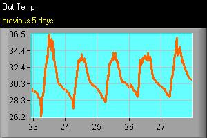
In chennai the summer heat is building by the day.. take a look at the last 5 days Temperature chart.
As we have monitored the south bay for the past 3 months, there was considerable activity... NOW all of a sudden a cloud mass has developed into a well marked LOW pressure system., then today it's a Tropical Depression laid center at 750KM east-southeast of Chennai.
Take a look at the development of the system and the latest PIC of the system.


Both JWTC and Indian Met department are tracking it as a potential tropical cyclone.
According to Indian Met office report...
"Yesterday's low pressure area over southeast Bay of Bengal has intensified in to a depression and lay centred at eight thirty hrs IST of 27th April within half a degree of latitude twelve degrees north and longitude eighty seven degrees east at about seven hundred fifty kilometres east-southeast of Chennai. The system is likely to intensify further and move initially in a northwesterly direction."
But according to the JWTC/US Navy prediction...

the system is predicted to move in a North-East direction.
Even the COLA numeric forecast also suggests same as JWTC..
If it moves West or North-west... we (Chennai) might be on the way.
Let's wait for tomorrow and we'll see the direction.
Remember during 1st week of May-2004 a same kind of tropical depression crossed Chennai and South Andhra.
Monday, April 14, 2008
Some heavy showers down south
Thru the last week there was heavy activity over the Southern extreme end of Tamilnadu OR India.
Take a look at the Satellite pic dated ....

It clearly shows a small tropical low system moved from South-Bay crossing Srilanka and Then brushing the Southern Tip.
This caused widespread very heavy rain over that region.

Take a look at the present satellite pic, the South-bay is somewhat calm after 2 months of intense activity.
This calm is not going to be long...!
Thursday, April 10, 2008
Global Warming Tax?
Billed as a “climate change mitigation and adaptation fee,” the measure would cost motorists either an additional 3 percent motor fuel tax, or up to a $90 annual flat fee, based on vehicle emissions. The new charges would be on top of taxes already paid at the pump. Either option requires a majority approval by a vote of the people.
“At this point the people of the Los Angeles region have just had it when it comes to traffic and air quality,” claimed Assemblyman Mike Feuer, a Los Angeles Democrat and author of Assembly Bill 2558.
for more read ...http://www.desertdispatch.com/opinion/global_3006___article.html/warming_tax.html
Is this a good idea? Should more cities, states or even the federal government implement something like this? Like to hear your thoughts.
Something wrong over south-Bay

Take a look at the latest sat pic...
we can see a small swirl near to Srilanka...
After 133 yrs the south tamilnadu is experiencing a monsoon like weather during this time of the year.
Here in Chennai, it's almost clear less humid and hot with Hi: 34.7°C @ 1:19pm.
Sunday, April 06, 2008


Predicting Weather Based On Cloud Patterns
Puffy white clouds sailing across a blue sky indicate continuing fair weather. But if they mass together to form tall, anvil-shaped clouds, be prepared for a lightning-filled thunderstorm, even if the sun in shining brightly.
Striped frosty clouds high in the sky indicate the probability of light rain; dark, layered clouds overhead mean steady rain or snow. If you are ever lost at sea, look for the patches of stationary woolly clouds that usually form a little to the windward side of an island.
If your ever out on a clear night and the moon is shining, one way to know that bad weather is coming is to see a ring around the moon, rain or snow depending on the time of year will usually come within 3 days
Heat is slowly picking up!
In Chennai the heat is slowly picking up, for the past 5 days it was around 33°C.
The humidity is also high, so it's sultry day and mild nights.
Still the wind direction is from South-East and this is favorable for an electric shower.
The southern tamilnadu is experiencing some electric showers then and there.
Still we can see the south BAY is active with upper cyclonic circulation and the Sea temperature is also a bit high.

Tuesday, April 01, 2008

"92B", no threat

As the numeric forecast suggested the "92B" dissipated around the central bay.
Chennai is experiencing the HEAT again for the first time in this Initial Summer burst..
Yesterday's Hi: 35.2°C @ 10:30am Low: 27.2°C @ 6:25am
But at around 1:30 PM there was widespread electric showers...it was heavy at places.
And recorded a 16mm for the day.
Today is April-1 "April Fool's Day"...but this day will mark the start of Summer-2008 for Chennai.
For the past 5 days, the wind direction is again favorable for the moisture from the sea to set in around mid-noon and then later develop into an electric shower.

Another thing, going by the satellite pic we can see the south bay area is still very much active.
I think we can expect a Hot, Humid and Wet APRIL.
Subscribe to:
Posts (Atom)