Saturday, August 29, 2009

Normal rain in 12 of 36 'monsoon divisions'

Over 500 mm rainfall this season.

The revival of rainfall across the country over the past two weeks has helped a third of the country achieve the normal average level for the June-August period.

Of the 36 'monsoon divisions' into which the India Meteorological Department (IMD) has divided the country, 12 have achieved the normal average for this three-month period this year, thanks to the revival of the past fortnight.

HOPE RETURNS
Division-wise rainfall comparison
Period June-Aug
27, 2008
June-Aug
19, 2009
June-Aug
26, 2009
Excess 6 divisions 1 division 1 division
Normal 26 divisions 9 divisions 12 divisions
Deficient 4 divisions 25 divisions 22 divisions
Scanty 0 division 1 division 1 division
Note: Excess: ( +20% or more)Normal : (+19 % to -19%)
Deficient: (-20% to -59%) Scanty: (-60% to -99%)
Source: India Meteorological Department, Pune

However, three parts in the country - Haryana, Himachal Pradesh and western Uttar Pradesh - have an average rainfall deficiency of more than 50 per cent as of now.

Tamil Nadu, Kerala, Karnataka, Orissa, Sikkim and Arunachal Pradesh, along with central Maharashtra, Rayalaseema (Andhra), Lakshadweep and Andaman and Nicobar Islands have crossed the normal average level. There are still 22 monsoon divisions, primarily in the states of Uttar Pradesh, Bihar, Jharkhand, Rajasthan, Andhra Pradesh and Maharashtra, which have reported deficient rainfall. The deficiency levels however have come down distinctly.

Haryana remains the only division with scanty rainfall (less 64 per cent) and Saurashtra-Kachchh in Gujarat the only region reporting excess rainfall (more by 29 per cent) till August 26, the IMD reports show. The entire country has got 514.3 mm of rainfall this season, almost 25 per cent less than the average normal of 682 mm till August 26.

A top IMD official told Business Standard there were chances of few more regions achieving the normal average rainfall level by the second week of September. "The situation in Haryana, Himachal Pradesh and western UP is really tough. These regions might not recover the shortfall of rains this season. Last year, over the same period, 26 divisions had received the normal average rainfall. The only positive aspect is that deficiency levels have sharply reduced across a number of monsoon divisions," the official stated.

Climate change threatens India's monsoons

One of India's leading meteorologists has given warning that in Central India the "days of long duration rains are almost gone".

In a study of monsoon patterns in India over the last 150 years, BN Goswami, director of the Indian Institute of Tropical Meteorology, said global warming had made India's weather more unpredictable.

His comments will fuel fears that climate change will cause increasing hardship for farmers in India, where the failure of the monsoon has already reduced food output by 20 per cent. Ministers reduced the country's growth projection this year by just under two per cent as drought hit crops throughout the country.

Finance Minister Pranab Mukherjee this week said there had been a 25 per cent decline in rainfall this monsoon in 252 districts throughout ten states, while in Maharashtra crop yields fell by more than 40 per cent.

The increasing failure of the monsoon has been attributed to a number of factors including temperatures rising by an average on 0.5 degrees Celsius over the last hundred years, receding Himalayan glaciers and rising sea levels. Intensive farming in land reclaimed from tropical forests in the south of India, and the irrigation of farmland in the dusty northern plains have also affected the monsoon, delaying its arrival from June into July.

"It is a warning to our policy-makers and a challenge for the people to adapt to new rainfall trends," Mr Goswami said.

Study says shines light on sun spot-climate link

Small changes in the energy output of the sun can have a major impact on global weather patterns, such as the intensity of the Indian monsoon, that could be predicted years in advance, a team of scientists said.

The sun swings through an 11-year cycle measured in the number of sun spots on the surface that emit bursts of energy.

The difference in energy is only about 0.1 percent between a solar maximum and minimum and determining just how that small variation affects the world's climate has been one of the great challenges facing meteorologists.

Using a century of weather observations and complex computer models, the international team of scientists led by the National Center for Atmospheric Research (NCAR) in the United States showed that even a small increase in the sun's energy can intensify wind and rainfall patterns.

"Small changes in the sun's output over the 11-year solar cycle have long been known to have impacts on the global climate system," said Julie Arblaster, from the Centre for Australian Weather and Climate Research, a co-author of the study published in the latest issue of the journal Science.

"Here we reconcile for the first time the mechanisms by which these small variations get amplified, resulting in cooler sea surface temperatures in the tropical Pacific and enhancing off-equatorial rainfall."

The researchers found that during periods of strong solar activity the air in the upper atmosphere, in a layer called the stratosphere, heats up. This occurs over the tropics, where sunlight is typically most intense.

The extra warming alters wind patterns in the upper atmosphere, which in turn increases tropical rainfall.

Increased sunlight at solar maximum also causes a slight warming of ocean surface waters across the subtropical Pacific, where clouds are normally scarce, says the study.

This extra heat leads to more evaporation, producing additional water vapour. The extra moisture is carried by trade winds to the normally rainy areas of the western tropical Pacific, driving more rain.

PREDICTIONS

In the tropical eastern Pacific, sea surface temperatures cool a little, creating conditions similar to a La Nina event. La Nina is the opposite phenomenon to El Nino, producing wetter weather in the western Pacific and drier weather in parts of South America.

The Indian monsoon and many other regional climate patterns are largely driven by rising and sinking air in the tropics and subtropics. Solar-cycle predictions could help meteorologists estimate how those circulation patterns, changes in sea surface temperatures and regional weather patterns might vary.

"The sun, the stratosphere, and the oceans are connected in ways that can influence events such as winter rainfall in North America," says NCAR scientist Gerald Meehl, lead author of the study.

"Understanding the role of the solar cycle can provide added insight as scientists work toward predicting regional weather patterns for the next couple of decades."

The sun is presently in a calm period after reaching a solar minimum at the end of last year, according to the Space Weather Prediction Center at the National Oceanic and Atmospheric Administration in the United States.

The next solar peak is expected in May 2013. (For more details, see: www.swpc.noaa.gov/SolarCycle/)

"This paper represents a useful step forward in understanding how solar activity may lead to modest but detectable climatic effects," said Brad Carter, senior lecturer in physics at the University of Southern Queensland, Australia.

"It is a good reminder that solar activity is not an explanation of global warming over recent decades."

Ocean ride in "Chennai" from Sept

An ocean ride within the Chennai port limits is all set to be launched for the first time in the city in September. The ride, which will be on a 30-seater steel boat, is being organised by the Indian Institute of Logistics (IIL).At a press meet on Thursday, IIL founder-director Capt VJ Pushpa Kumar said this initiative was being planned for his love for the sea as a mariner. "We plan for the ride to span an hour costing Rs 300 per seat. The boat will come with trained professionals, apart from navigation equipment, weather forecast material and adequate safety measures. The ride is planned to end near the light house, though the exact tour details are yet to be finalised," he explained. A Goa-based Naval architect has been roped into the ocean ride project, to check stability of the boat to enhance its safety levels in sea. "We have already acquired permission from the Madras Mercantile Marine Department for this project and I hope this initiative not only helps to develop coastal tourism but also instills love for the sea among youngsters," Capt Kumar added. "This plan is only a precursor for our dreams to take coastal tourism to a bigger level in the east coast, which still hasn't been exploited as a tourism opportunity," henoted. The Indian Institute of Logistics, which has completed two years, has over 400 students in all, including its Chennai, Vijaywada and Kochi units. The institute offers diplomas, postgraduate diplomas and MBAs in various Logistic-related courses.

Human-generated aerosols from northern hemisphere may affect rainfall patterns in Australia

Australian scientists, using a climate model, have suggested that human-generated aerosols from the northern hemisphere may have contributed to increased rainfall in north-western and central Australia, and decreased rainfall in parts of southern Australia.

According to lead researcher, Dr Leon Rotstayn, Principal Research Scientist at the Centre for Australian Weather and Climate Research, a partnership between CSIRO and the Bureau of Meteorology, "Perhaps surprisingly, inclusion of northern hemisphere aerosols may be important for accurate modelling of Australian climate change."Aerosols come from many different sources.

Sulphur is released when we burn coal and oil. More dust, also an aerosol, circulates in the atmosphere when land is cleared, burned or overgrazed.

Some aerosols occur naturally like sea spray and volcanic emissions, but NASA estimates ten percent of the total aerosols in the atmosphere are caused by people.

Most of this ten percent is in the northern hemisphere.
European researchers, attending the international 'Water in a changing climate' science conference in Melbourne from August 24-28, will discuss a new forecasting service that will identify in unprecedented detail where these aerosols are coming from and where they are going.

The new service, part of Europe's Global Monitoring for Environment and Security (GMES) initiative, will give global information on how pollutants move around the world across oceans and continents, and will refine estimates of their sources and sinks.

According to Dr Adrian Simmons from the European Centre for Medium-Range Weather Forecasts, which is coordinating the multi-institution initiative, "The service will give much more detailed forecast information on air quality over Europe and provide the basis for better health advice across Europe and beyond".

The service has clear implications for environmental policy and legislation.

Heavy rain forecast for Chennai in 72hrs ... http://ping.fm/tjGhi

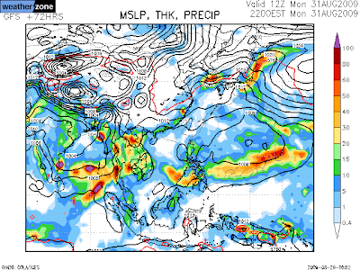
Heavy rain forecast for Chennai in 72hrs


Latest GFS predicts more activity over southern Bay and even predicting heavy showers for Chennai on 31-Aug-2009 and 1-Sep-2009.
Follow our tweets for regular updates on this prediction .. http://twitter.com/weatherofindia
From early morning Gujarat is getting good monsoon showers, North BAY is clear .. http://ping.fm/kdpwk
RT @mumbaitimes: Five more swine flu deaths, India's toll 83: from Bijapur. According to Maharashtra health authoriti.. http://bit.ly/ydb8p
MumbaiTimes
Chennai - Another clear sky morning, No wind, getting Hot and Cloud formation expected after 1 pm.