
Saturday, May 31, 2014
Friday, May 30, 2014

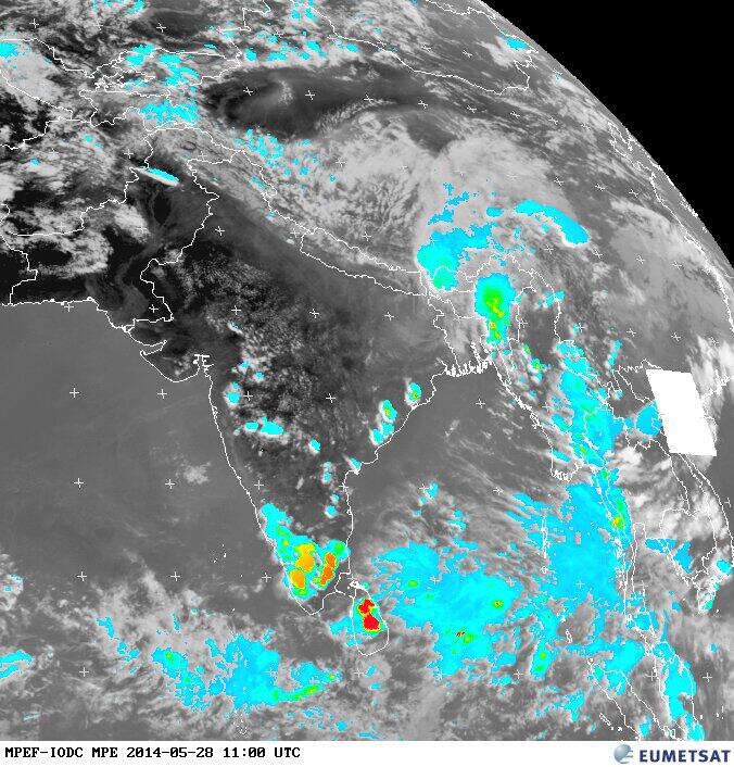
5:30pm, Visible shot shows...
T showers dotted over S,central,N-central Peninsula.
#Delhi "storm" ... http://ow.ly/i/5JVe1

T showers dotted over S,central,N-central Peninsula.
#Delhi "storm" ... http://ow.ly/i/5JVe1
W.D and Heat !

4pm, T cells popping over W,central Andhra, S Kerala, S Tamilnadu and S Karnataka ... http://ow.ly/i/5JOuN
4pm, Due to W.D, Heavy T shower seen over N Haryana ... http://ow.ly/i/5JOuN

An upper,mid-level W.D trough is now over N Pakistan ... and expected to push E-N-E across N,N-W India in 24hrs ... http://ow.ly/i/5JOMn
In next 36-48hrs, scattered T showers is expected over Kashmir, Punjab, Himachal, N,N-E Rajasthan, Haryana ... http://ow.ly/i/5JORU

RT @GanpatTeli1: Storm in #delhi @weatherofindia (4:58pm)
#Delhi to get more rain on tomorrow, 1-Jun.
This W.D will affect N,N-W,N-central India on 31-May and 1-Jun.
Super #HOT days ahead for most of N,N-W,central,E-central,N,N-central Peninsula India till 5-Jun ... http://ow.ly/i/5JQ3F

Stormy #Delhi -- a video from Instagram ... http://ow.ly/xqPM8
Monsoon for Kerala on 5-Jun !

Today, low-level trough is seen from S,central Uttarpradesh to S Tamilnadu ... http://ow.ly/i/5JI7I
This low-level trough is expected to persist almost in same position during next 2 days.
On 1-Jun, a good low-level circulation is expected in the N-S trough over S,central Andhra ... http://ow.ly/i/5JIaQ
Monsoon update ::
~~~~~~~~~~~~~~~~~~

SW Monsoon is now over S Srilanka !
And expected to cover entire Island on 3/4-Jun only... http://ow.ly/i/5JIiE
Sea surface temperature along Somali coast is slowly reducing and now it's around 24 C... http://ow.ly/i/5JIuZ
It should go below 20 C

Latest model suggests that Monsoon will break into S Kerala coast, S tip Tamilnadu on 5-Jun-2014 ... http://ow.ly/i/5JICZ
High pressure near Madagaskar is strengthening, now around 1024 hpa... and should reach 1030hpa in next 2 week.. http://ow.ly/xqmTi

A perfect pressure map for Monsoon is expected on 5-Jun, with N-W India LOW at 992mb and an offshore trough in S-W http://ow.ly/i/5JIN8
Good showers expected along S,central Kerala coast, S tip Tamilnadu during early morning, morning hrs expected from 2/3-Jun.
Rainfall alert for next 36hrs ::
~~~~~~~~~~~~~~~~~~~~~~~~~

Before midnight today, Heavy T showers expected along W-ghats of Kerala, W-ghats, S,central Karnataka ... http://ow.ly/i/5JIXY
Today, Isolated T showers possible over W,central,N,S Andhra as well.
Today, tomorrow - T showers possible over N,N-W,N-central,N-E Tamilnadu ... http://ow.ly/i/5JJ3v
Tomorrow as well, T showers will continue over W-ghats, central,N-central Kerala !
#Chennai - T cells will push near to 70km from city along W,S-W zones on today, tomorrow.
This scenario is happening during past 1 week !
Thursday, May 29, 2014
The strengethening of SWM Power House.
Mauritius Meteorological Service
The strengthening of High near Madagaskar is evident. This gives a ray of hope for the much expected SWM flow into Arabian Sea in the ensuing days. As pointed out by a seasoned meteorologist cross equatorial bursts in Arabian Sea are noticed.
This will enhance the upheaval near Somalia coast to make a fall [rapid] in SST there and ensure monsoon wind to lash west coast of India.
The strength 1024 hPa is quite normal for this time. But still it is in pre monsoon stage.
There is yet another segment of High with 1020hPa and it gives cross equatorial winds across Bay
 |
| 270514 12Z |
 |
| 290514 12Z |
This will enhance the upheaval near Somalia coast to make a fall [rapid] in SST there and ensure monsoon wind to lash west coast of India.
The strength 1024 hPa is quite normal for this time. But still it is in pre monsoon stage.
There is yet another segment of High with 1020hPa and it gives cross equatorial winds across Bay
Bengaluru / Bangalore today !

RT @rajugana: Bangalore 4.50pm, Sunny & Scorching day; formation of clouds in the eastern side..will it rain? a pic http://t.co/HXK0l7MPqT

RT @rajugana: Bangalore 7.00pm, Sudden development of dark clouds and localized downpour @ Marathahalli area http://t.co/UzM5Z6zo8U
#Instagram from Bangalore
~~~~~~~~~~~~~~~~~~~~~~~~~~
Barmer records 47.2 C on 28-May-2014
#HOT above 45s of 28-May...
Barmer = 47.2 C
Jaisalmer=46.6
Bikaner=46.2
Churu=45.7#HOT above 45s of 28-May...
Barmer = 47.2 C
Jaisalmer=46.6
Bikaner=46.2
Churu=45.7
Kota=45.4
Kandla = 45.3
Jodhpur = 45.2
Ganganagar = 45.1
Kota=45.4
Kandla = 45.3
Jodhpur = 45.2
Ganganagar = 45.1
#HOT at 1:40pm,
Nagpur = 45 C
Lucknow = 44 C
Delhi, Jaipur = 43 C
Ahmedabad, Amristar, Hyderabad, Varanasi = 42 C
#Chennai - 1:40pm, Temperature is 37 C and feels like 44.6 C.
Sea breeze has set in from E-S-E.
1:30pm, partly cloudy and HOT looking India ... http://ow.ly/i/5J0VN
#Chennai - 3:40pm, lots of mini T cells has popped over W,W-N-W,S-W from city from 50 to 200km... http://ow.ly/i/5J12h
Barmer = 47.2 C
Jaisalmer=46.6
Bikaner=46.2
Churu=45.7#HOT above 45s of 28-May...
Barmer = 47.2 C
Jaisalmer=46.6
Bikaner=46.2
Churu=45.7
Kota=45.4
Kandla = 45.3
Jodhpur = 45.2
Ganganagar = 45.1
Kota=45.4
Kandla = 45.3
Jodhpur = 45.2
Ganganagar = 45.1
#HOT at 1:40pm,
Nagpur = 45 C
Lucknow = 44 C
Delhi, Jaipur = 43 C
Ahmedabad, Amristar, Hyderabad, Varanasi = 42 C
#Chennai - 1:40pm, Temperature is 37 C and feels like 44.6 C.
Sea breeze has set in from E-S-E.
1:30pm, partly cloudy and HOT looking India ... http://ow.ly/i/5J0VN
#Chennai - 3:40pm, lots of mini T cells has popped over W,W-N-W,S-W from city from 50 to 200km... http://ow.ly/i/5J12h
Weather Instagram at May 29, 2014 at 12:41PM
#chennai - 12:37pm, #hot. Photo taken inside a lush green movie shooting spot. #weather
Wednesday, May 28, 2014
A weak W.D is expected to affect N Pakistan into Kashmir, Punjab, Himachal on 31-May... http://ow.ly/i/5Ippq
Monsoon for Kerala after 4-Jun-2014 !!

Monsoon for Kerala :
Only a weak current is expected to reach S Kerala coast, S tip Tamilnadu on 4/5-Jun.. http://ow.ly/i/5IonM

Monsoon for Kerala is expected after 3/4-Jun !
NAVGEM model also suggests a weak set-in over S Kerala on 4-Jun ... http://ow.ly/i/5IoGq
NAVGEM model suggests a circulation to pop over S Arabian sea on 31-May and move W-N-W on 1,2,3,4-Jun ... http://ow.ly/i/5Ipay
RT @Arvind_LFC: @weatherofindia 4:30pm, Heavy thunderstorm over central,west TN http://t.co/wMX6VyLvH9
4:30pm, T showers also over S,central Odisha, S,central Andhra, S,W,N-W Maharastra, S,S-W Karnataka, N,central Kerala http://t.co/wMX6VyLvH9

Monsoon Watch-5 put up on Vagaries...Monsoon advance into Sri Lanka seen by May end, and in Kerala 2.3 June...But hotter days in Central and Northern India.
El Nino should be full fledged by August.
El Nino should be full fledged by August.
Tuesday, May 27, 2014
Thunderstorm in Badlapur on 27- May- 2014.


Badlapur recorded 9mm rainfall till 5.30pm today. And temp was drop to 25.7c while time of storm at 4.30pm.
Monsoon for Kerala can be delayed beyond 3-Jun-2014.

In next 36hrs, the low-level circulation of 92B is expected to die over N,central Bengal ... http://ow.ly/i/5HsEC
On 29-May, the inland N-S trough from Bihar to N,N-central Tamilnadu will re-establish again ... http://ow.ly/i/5Hsmt

Around 29/30-May, the N-W to E India Heat LOW is expected to be around 998mb and this forms the monsoon axis.. http://ow.ly/i/5HsLi
The Arabian sea offshore trough is also expected to take shape slowly around 29/30-May... http://ow.ly/i/5HsLi
Monsoon for Kerala can be delayed beyond 3-Jun-2014.
But monsoon current expected to push into Bangladesh, S Bengal,N-E states on 3-Jun !
Rainfall alert for next 36hrs ::
~~~~~~~~~~~~~~~~~~~~~~~~~~~~~~~~~~~~~~

During next 12hrs, T showers expected over W-Ghats Kerala, N,N-W,N-central,N-E Tamilnadu and into S,S-central Karnataka, S Andhra.
HEAVY widespread rain to continue over Jharkhand, central,N Bengal and into Bihar till noon of 28-May.
Tomorrow, more T showers expected ALL along W-ghats Kerala, W-ghats Karnataka, N,N-W,N-E,N-central Tamilnadu... http://ow.ly/i/5HtXA
On 28-May, Scattered T showers also for S,S-central Karnataka, S,W,S-central,N-E Andhra ... http://ow.ly/i/5Hu0b
T showers over peninsula and remnant of 92B
#HOT at 3pm...
Ahmedabad = 45 C
Nagpur = 42 C
Jaipur = 39 C
Amristar, Delhi, Thiruchirapalli = 38 C
#HOT 40s of 26-May...
Jaisalmer = 44.3 C
Barmer = 45.2 C
Bhuj = 45.4 C
Rajkot = 43 C
#Chennai - Airport, 3:15pm, temperature is 36 C, Sea breeze has set in.
Yesterday max was 38.8 C

3pm, T showers has popped over W,S-W,S Maharastra, S,S-central Karnataka, N,N-E Tamilnadu, N-central,S,central Andhra http://ow.ly/i/5HrSk
3pm, Remnant of 92B is giving more rain to S,central Bengal, Jharkhand, Bihar and into N,W Bangladesh ... http://ow.ly/i/5HrSk
3:40pm, lots of T showers seen over N,N-E Tamilnadu... around 50 to 200km in W, W-N-W direction from Chennai ... http://ow.ly/i/5Hs1d

Now, the remnant of 92B is seen over N Jharkhand, W Bengal ... http://ow.ly/i/5Hsam
Today, a low-level circulation is seen over E-central Maharastra and its trough upto N-W Tamilnadu ... http://ow.ly/i/5Hsam
A line of wind discontinuity can be seen from the Maharastra circulation to S Arabian sea weak circulation ... http://ow.ly/i/5Hsam
RT @rajugana: @weatherofindia Bangalore 4.15pm, Massive T. Clouds from eastern side waiting to cross...a pic http://t.co/OQiZEY39VN

Ahmedabad = 45 C
Nagpur = 42 C
Jaipur = 39 C
Amristar, Delhi, Thiruchirapalli = 38 C
#HOT 40s of 26-May...
Jaisalmer = 44.3 C
Barmer = 45.2 C
Bhuj = 45.4 C
Rajkot = 43 C
#Chennai - Airport, 3:15pm, temperature is 36 C, Sea breeze has set in.
Yesterday max was 38.8 C
3pm, T showers has popped over W,S-W,S Maharastra, S,S-central Karnataka, N,N-E Tamilnadu, N-central,S,central Andhra http://ow.ly/i/5HrSk
3pm, Remnant of 92B is giving more rain to S,central Bengal, Jharkhand, Bihar and into N,W Bangladesh ... http://ow.ly/i/5HrSk
3:40pm, lots of T showers seen over N,N-E Tamilnadu... around 50 to 200km in W, W-N-W direction from Chennai ... http://ow.ly/i/5Hs1d
Now, the remnant of 92B is seen over N Jharkhand, W Bengal ... http://ow.ly/i/5Hsam
Today, a low-level circulation is seen over E-central Maharastra and its trough upto N-W Tamilnadu ... http://ow.ly/i/5Hsam
A line of wind discontinuity can be seen from the Maharastra circulation to S Arabian sea weak circulation ... http://ow.ly/i/5Hsam
RT @rajugana: @weatherofindia Bangalore 4.15pm, Massive T. Clouds from eastern side waiting to cross...a pic http://t.co/OQiZEY39VN
Monday, May 26, 2014
Vellore - T showers nearing at 6:30pm
Vellore - 6:25pm, "T shower is nearing the town"
Chennai - 6:30pm, a T shower is nearing Vellore town.
More rain seen from 80 to 150km over W-S-W from Chennai city http://ow.ly/i/5GQYO

#Vellore - 6:59pm, "Heavy T shower now"
Chennai - 6:30pm, a T shower is nearing Vellore town.
More rain seen from 80 to 150km over W-S-W from Chennai city http://ow.ly/i/5GQYO
#Vellore - 6:59pm, "Heavy T shower now"
Forecast on 92B, Arabian sea circulation and Monsoon onset

During next 24hrs, the low-level trough from the existing 92B will dip S-W upto S-E Arabian sea... http://ow.ly/i/5GMRD
Tomorrow, there can be 2 low-level circulations, one will be remnant of 92B over Jharkhand and another over S Madhyapradesh.
Tomorrow as well, the trough will drop S-W from S Madhyapradesh upto S-E Arabian sea at low-levels... http://ow.ly/i/5GN1F
On 29-May, the inland low-level N-S trough will re-establish again from Bihar to N,N-central Tamilnadu... http://ow.ly/i/5GN66
Monsoon update ::
~~~~~~~~~~~~~~~~~~~

S, S-S-W Arabian sea is expected to pop a circulation in next 1 or 2 days, but GFS model did not expect this to sustain !
Weak monsoon current is expected to make a presence along S Kerala coast, S tip Tamilnadu on 30/31-May, rain expected http://ow.ly/i/5GNjn Models expect a strong circulation over S-S-E Arabian sea on 1-Jun ... this may further delay the monsoon onset !! http://ow.ly/i/5GNmE
Rainfall alert for next 36hrs ::
~~~~~~~~~~~~~~~~~~~~~~~~~~~~~~~

Today before midnight, Heavy rain due to 92B will sweep further upto N,central Chatisgarh, Bihar, Jharkhand and S-E,E Uttarpradesh as well.
From now, showers over S Bengal will go down and more rain ahead for central,N Bengal even till midnight tomorrow http://ow.ly/i/5GNGX
From now and before 12am, T showers expected over N,N-E,N-central Tamilnadu, S,W Andhra, S,central,E,N Karnataka.
Already getting reports of T showers from Bangalore 5:05pm.
RT @RajanRamaswami: @weatherofindia Now at JP Nagar V Phase Bangalore heavy rains with thunder started.. (5:06pm)
Chennai - 5pm, Heavy T showers seen over W,W-N-W from city at 175km, 120km and 80km ... http://ow.ly/i/5GNOq

#Chennai - W,S-W,N-W suburbs can expect a T shower pushing in from W-N-W on today late evening and tomorrow evening.
35% chance of rain.
Under the influence of 92B, Most of East India (Odisha included) can expect T shower activity till 28-May... http://ow.ly/i/5GNVO
More T showers ahead for w-ghats of Kerala, W-ghats Tamilnadu and W-ghats of S-W Karnataka on today, tomorrow.
S kerala coast, S tip Tamilnadu coast can expect early morning showers on tomorrow as well due to Monsoon current !
92B is inland over Odisha coast.
92B effect.
Kolkata - 1:43pm, "Mass Thunderstorm hits Kolkata
120mm/hr rains lashing kolkata now
winds 20km/h"

LOW pressure 92B has pushed inland into Odisha coast around early hrs of today ... http://ow.ly/i/5GKgf
Today, a low-level trough from this 92B is seen dipping South upto S-E coast of Tamilnadu ... http://ow.ly/i/5GKja
92B is expected to weaken and drift N-N-W during next 24hrs and then push N-E into N Bengal zone on 28-May ... http://ow.ly/i/5GKp9
2:30pm, Heavy rain due to 92B is seen over central Chatisgarh, Odisha, Bengal, Jharkhand and into Bihar ... http://ow.ly/i/5GKtd

Kolkata - 1:43pm, "Mass Thunderstorm hits Kolkata
120mm/hr rains lashing kolkata now
winds 20km/h"
LOW pressure 92B has pushed inland into Odisha coast around early hrs of today ... http://ow.ly/i/5GKgf
Today, a low-level trough from this 92B is seen dipping South upto S-E coast of Tamilnadu ... http://ow.ly/i/5GKja
92B is expected to weaken and drift N-N-W during next 24hrs and then push N-E into N Bengal zone on 28-May ... http://ow.ly/i/5GKp9
2:30pm, Heavy rain due to 92B is seen over central Chatisgarh, Odisha, Bengal, Jharkhand and into Bihar ... http://ow.ly/i/5GKtd

Sunday, May 25, 2014
25th May 2014 BOB Low Pressure Circualtion
A Low Pressure Area over North BOB
and adjoining orissa , expected to move over WB by 26th May 2014
Saturday, May 24, 2014
92B - drifted W-N-W and showing signs of intensification again

During past 28hrs, "92B" has persisted as LOW pressure and drifted W-N-W and now over N-central,N-W Bay.
Now it's even showing signs of further intensification into a Depression again.
Pressure at present is around 1001mb.

10:30pm, Satellite shows the convective activity can be close to coast of Odisha and into Odisha as well.

Latest GFS predicts it can deepen further into a depression and cross into N-E Odisha coast, S Bengal coast on early hrs of Monday, 26-May.
Due to this, Heavy rain expected along Odisha coast, S,central Bengal, Kolkata from mid-morning of Sunday.
Towards evening and midnight of 25-May - Heavy, very heavy rain expected over N-E Odisha coast, S,S-W Bengal.
During afternoon, T showers will break in over N-E Andhra and over N,N-E Tamilnadu as well.
Tomorrow again, T showers possible along W-ghats of Kerala.
Monsoon update ::
~~~~~~~~~~~~~~~~

In another development, a low-level trough can be seen from 92B tilting S-W across South peninsula and into South Arabian sea... this will pop a low-level circulation over S,S-S-E Arabian sea in next 24 hrs.
Initially this circulation is expected to drift W-N-W, but this can enable a weak Monsoon current along S,central Kerala coast on 29/30-May.
Today as well good cross equatorial winds are reaching Somali coast and into Maldives. Most of the winds are below the 5th parallel.
Subscribe to:
Posts (Atom)