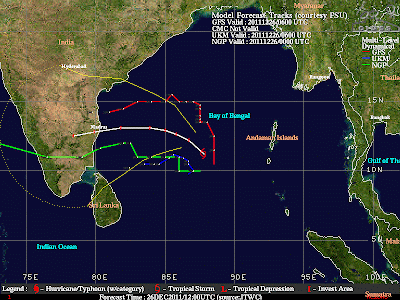
Position :: 10.3 N and 88.5 E
Winds :: 65 Km/Hr
Pressure :: 996 mb
Moved N-N-W in past 6 hrs
Latest satellite IR shot,
-------------------------------------------------------
JTWC warning & Projected path
---------------------------------------------------------
TROPICAL CYCLONE (TC) 06B (SIX), LOCATED APPROXIMATELY 505 NM EAST-
SOUTHEAST OF CHENNAI, INDIA, HAS TRACKED JUST WEST OF NORTHWARD AT
06 KNOTS OVER THE PAST SIX HOURS. ANIMATED MULTISPECTRAL SATELLITE
IMAGERY SHOWS THE LOW LEVEL CIRCULATION CENTER (LLCC) HAS BECOME
FULLY EXPOSED AS CONVECTIVE BANDING REMAINS DISPLACED TO THE NORTH.
THE INITIAL POSITION WAS BASED ON THE ABOVE ANIMATION WITH HIGH
CONFIDENCE AND THE INITIAL INTENSITY WAS BASED ON THE HIGH END OF
DVORAK ESTIMATES FROM PGTW AND KNES. UPPER LEVEL ANALYSIS INDICATES
THE CYCLONE IS JUST TO THE SOUTH OF THE RIDGE AXIS IN AN AREA OF
MODERATE (15-20 KNOT) VERTICAL WIND SHEAR (VWS). WATER VAPOR
SATELLITE ANIMATION SHOWS EXCELLENT POLEWARD OUTFLOW ENHANCED BY THE
WESTERLIES NORTH OF THE RIDGE. THE SYSTEM IS CURRENTLY TRACKING
ALONG THE WESTERN PERIPHERY OF A DEEP-LAYERED SUBTROPICAL RIDGE TO
THE EAST. IT IS EXPECTED TO TRACK MORE WESTWARD OVER THE NEXT 24
HOURS AS THE STEERING RIDGE BUILDS AND EXTENDS FURTHER WESTWARD TO
THE NORTH OF THE SYSTEM. TC 06B WILL EXPERIENCE MODERATE INTENSI-
FICATION, HINDERED BY CONTINUED MODERATE VWS. THE SYSTEM WILL
MAKE LANDFALL NEAR CHENNAI AND DISSIPATE INLAND BY TAU 120. THE
AVAILABLE NUMERICAL GUIDANCE IS IN OVERALL GOOD AGREEMENT. THIS
TRACK FORECAST IS JUST TO THE RIGHT OF THE CONSENSUS. MAXIMUM
SIGNIFICANT WAVE HEIGHT AT 260600Z IS 12 FEET. JUSTIFICATION FOR
RELOCATION: RELOCATED PREVIOUS WARNING'S INITIAL POSITION
SIGNIFICANTLY EASTWARD IN VIEW OF RECENT ANIMATED MULTISPECTRAL
SATELLITE IMAGERY SHOWING A FULLY EXPOSED LLCC.

IMD warning, 1:30pm
--------------------------------------------------
Deep Depression over southeast Bay of Bengal- Pre-cyclone watch.
The deep depression over southeast Bay of Bengal moved northwards during past 6 hours and lay centred at 1130 hrs IST of today, the 26th December 2011 over southeast Bay of Bengal near latitude 10.00N and longitude 87.5.0E, about 850 km southeast of Chennai (Tamilnadu), 670 km east-northeast of Trincomalee (Srilanka), 600 km southwest of Port Blair (Andaman & Nicobar island). The system is likely to move northwestwards, intensify into a cyclonic storm during next 24 hrs. Then it is likely to move west-northwestwards and cross north Tamil Nadu and south Andhra Pradesh coast between Cuddalore and Nellore by morning of 29th December 2011
COLA model prediction
------------------------------------------------
COLA models predict a N. Tamilnadu landfall on 29/30-Dec as a Depression !!


