
Friday, November 06, 2009
latest satellite shot, which shows VERY heavy showers over south tip of Tamilnadu .. http://is.gd/4P0M3
Arabian sea Cyclone and North-East Monsoon
5th wet day for Chennai today (6-Nov-09).
THis heavy intermittent showers for Tamilnadu & Chennai coast will continue till atleast Monday (9-Nov-09) morning.
The LOW pressure trough over Kanyakumari and Gulf of Mannar seas will continue till tomorrow evening before it moves to the west and forms into a Cyclone just north-west of Trivandrum.
Here's the latest satellite shot, which shows VERY heavy showers over south tip of Tamilnadu.


Video::
This GFS model video predicts a Cyclone formation over Arabian sea just along coast of Kerala and gradually intensifying and travelling fast along the coast. It's predicted to make landfall in a rather unusual zone... central Coast of Maharastra just south of Mumbai.
---
Heavy Rain to follow Chennai till Monday (9-Nov-09).
In this forecast model from BBC shows that Heavy rain persists over Chennai and along North Tamilnadu coast .. and please note that this model does not support Cyclone formation over Arabian sea along Kerala coast.
People of Chennai, embrace for more VERY heavy showers from early morning of 7-Nov-09, Saturday.
South TIP of India is getting battered by the Low pressure system hanging there .. http://ping.fm/ZCpBc
GFS predicts heavy widespread showers along Chennai and north TN coast to continue till 8-Nov-09 .. http://yfrog.com/2p6a8p
GFS suggesting a cyclone formation on 8-Nov-09, over Arabian sea along Kerala coast .. http://yfrog.com/10p6hp .. nothing over Bay
http://ping.fm/fJTXA .. satellite (1:30pm) shows very heavy rain activity over Bay just east of Chennai and just south of Tip of India
Moving into a WET phase
MJO suggests that we are movin into a wet MJO phase till 20-Nov-09.
And very DRY from 24-Nov to 15-Dec.
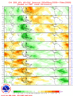
NE monsoon will be active over TN till 20-Nov-09.
This season we might not get the Cyclone over Bay..!!
And very DRY from 24-Nov to 15-Dec.

NE monsoon will be active over TN till 20-Nov-09.
This season we might not get the Cyclone over Bay..!!
N-E monsoon shifts into top gear over south peninsula
The Northeast monsoon has been active over Tamil Nadu and Puducherry during the past 24 hours ended Thursday morning with rainfall at most places and isolated heavy to very heavy falls.
Rainfall has also occurred at many places over Kerala and at a few places over Rayalaseema and Andaman and Nicobar Islands, an update from India Met Department (IMD) said on Thursday.
Most international models indicate more weather unfolding over the peninsula over the next week, with some saying that rains could linger in varying intensity over south peninsular India until November 20.
MJO WAVE ACTIVE
What has been driving the current active phase of the monsoon is the passage into the region from equatorial Indian Ocean (around Sri Lanka) of a wet phase of the Madden-Julian Oscillation (MJO) wave that criss-crosses the equatorial seas periodically from the west to east amplifying weather under its footprint.
The alternating dry phase of the MJO wave would kick in around November 23 when yet another round of the ‘Hard Dry’ would be triggered north from Sri Lanka and into peninsular India.
Meanwhile, the peninsular seas, especially the southeast Arabian Sea, are in a churn as of now. A US Joint Typhoon Warning Centre has put under watch an area of convection 185 nm south-southwest of Colombo.
Animated satellite imagery showed a broad region of cyclonic turning in the area, the JTWC said on Thursday. Convection (cloud-building) has started to deepen in the vicinity of the elongated low level circulation centre (LLCC, the nucleus around which a prospective storm builds) featuring wind-speeds between 10 and 15 knots, a couple of notches lower than the threshold for being classified as a low-pressure area.
Upper level analysis indicates the LLCC is located under a region of upper level divergence (the window effect that allows the storm to ‘breathe’ and grow) but vertical wind shear (the sudden rise in speeds) is moderate to high over the region.
MAY KILL STORM
Vertical wind shear kills storm building activity. This apart, the LLCC appears to be moving towards southern India, which is causing increased land effects from India and Sri Lanka. Storms need warm waters to move around and thrive. Proximity to land acts as a disincentive for them to grow and intensify.
Meanwhile, outgoing long-wave radiation from the earth is very strongly to strongly negative (which indicates the presence of cloud) for southern peninsular India, adjoining seas and Sri Lanka until November 20, according to the main MJO tracking models. The clouds are set up because of the active wet phase of the MJO.
This seems to be the principal reason why the US National Centres for Environmental Prediction (NCEP) is forecasting the possibility of prolonged rains for various parts of the peninsula until November 20.
According to the NCEP, the current active phase of Northeast monsoon would last until November 12 , will weaken to some extent later, but only to pick up afresh a few days after.
The US Navy’s NGP cyclone tracking model said that the churn in the warm seas around Colombo would track north along the Kerala coast, intensify a round on November 8 and 9, and yet another round the next day (a depression at best) before accosting comparatively cooler waters north of coastal Karnataka and the rest of the west coast and weakening.
The system is shown as drifting over land into west-central Maharashtra around November 11. The Global Forecasting System model of the NCEP too supported this outlook.
BAY ‘LOW’
The Canadian Meteorological Centre (CMC) said a ‘low’ could get generated over southeast Indian Ocean just off Indonesia, which could head straight west-northwest to southwest Bay of Bengal to approach the Chennai coast around this time.
The IMD said in its update on Thursday that a cyclonic circulation was traced to over the Comorin area. A trough from this system ran up to extreme south peninsula.
Under the influence of the existing cyclonic circulation, a low pressure area is likely to form during the next 24 hours with a trough extending to southwest Bay of Bengal off Tamil Nadu coast during the next two days.
Satellite cloud picture showed convective clouds over southeast Arabian Sea, southwest Bay of Bengal and around Comorin. Low to medium-high clouds were seen over some parts of south peninsula, Nicobar Islands, South Andaman Sea, and north and west-central Bay of Bengal.
Forecast up to Sunday spoke about the possibility of fairly widespread rainfall with isolated heavy falls over Tamil Nadu and Puducherry, Kerala and Lakshadweep.
Scattered to fairly widespread rainfall activity is likely over Andaman and Nicobar Islands, south coastal Andhra Pradesh and Rayalaseema.
A warning valid for the next two days said that isolated heavy to very heavy rainfall is likely over Tamil Nadu, Kerala and Lakshadweep.
Fairly widespread rainfall activity over south peninsular India will continue with isolated heavy to very heavy falls over Tamil Nadu and Puducherry, south coastal Andhra Pradesh, Kerala and Lakshadweep until November 10, the IMD said.
Satellite shows Very heavy showers over North TN coast and over south Tamilnadu and Kerala .. http://ping.fm/UNWbd
Very heavy showers for South Tamilnadu, south Kerala and along North TN coast
Chennai : Heavy snd steady showers continue from early morning.
Reports of Widespread showers all over north coastal Tamilnadu and over south Tamilnadu and Kerala.
Very heavy showers forecast for south Kerala and Tamilnadu in 24 hrs, as the Head of potential LOW pressure system is just crossing into Arabian sea.
Govt has announced Holiday for Schools and Colleges for many North TN districts.
Here's the latest satellite shot (taken at 8:30am IST)
We can see heavy activity over Bay just east of Chennai and over south Tamilnadu and Kerala.

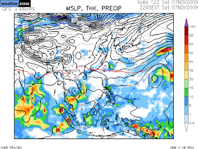
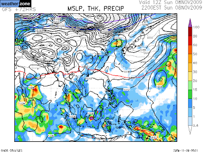
And here's the GFS forecast for next 72 hrs.
Heavy widespread showers to continue over north TN coast till evening of 9-Nov-09.. and we can see the emerging of LOW over Arabian sea along the Kerala coast.

Reports of Widespread showers all over north coastal Tamilnadu and over south Tamilnadu and Kerala.
Very heavy showers forecast for south Kerala and Tamilnadu in 24 hrs, as the Head of potential LOW pressure system is just crossing into Arabian sea.
Govt has announced Holiday for Schools and Colleges for many North TN districts.
Here's the latest satellite shot (taken at 8:30am IST)
We can see heavy activity over Bay just east of Chennai and over south Tamilnadu and Kerala.

And here's the GFS forecast for next 72 hrs.
Heavy widespread showers to continue over north TN coast till evening of 9-Nov-09.. and we can see the emerging of LOW over Arabian sea along the Kerala coast.


Subscribe to:
Posts (Atom)