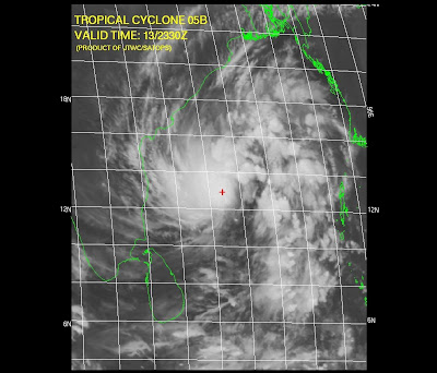
According to me it's moving north and slightly weak at this stage...
IMD's story:
********************************************
A depression over southeast and adjoining south west Bay of Bengal and lay centred at 1730 hours IST of yesterday, the 13th November 2008 near lat.11.5° N and long. 85.5° E, about 600 kms east-southeast of Chennai. It then moved northwestwards, intensified into a deep depression and lay centred at 0830 hours IST of today, the 14th November 2008, near lat. 12.5 N and Long. 85.0 E about 520 km east-southeast of Chennai and 600 km southeast of Machlipatanam. The system is likely to intensify into a cyclonic storm and move in a northwesterly direction towards coastal Andhra Pradesh. Under its influence, rainfall at most places with isolated heavy to very heavy falls is likely over coastal Andhra Pradesh and adjoining areas of Tamil Nadu during next 48 hours commencing from today, the 14th November 2008 afternoon.
********************************************
Latest JWTC projection and satellite pic...
********************************************
********************************************
Friday, November 14, 2008
REQUEST
If anyone reading/following this blog from South-Andhra or Chennai.
Please try to take "SNAPS" or "VIDEO" of the impact of CYCLONE and post it in FLICKR or YOUTUBE or Mail it to "freedownloadshop@gmail.com"
Dont' forget to send us the LINK, we'll publish it here.!
Thanks
ADMIN
Please try to take "SNAPS" or "VIDEO" of the impact of CYCLONE and post it in FLICKR or YOUTUBE or Mail it to "freedownloadshop@gmail.com"
Dont' forget to send us the LINK, we'll publish it here.!
Thanks
ADMIN
Category:
North East Monsoon
Cyclone "05B"... now a cyclone
Still it's not Named, Anyway it's "05B".
Look at the latest projection by JWTC...
It's destined to HIT South-Andhra. This is happenning after almost 2 years (according to my memory, I'll clarify on this later)
Chennai lies in a least danger zone.
Sky is cloudy and will be cloudy.
Typical sky before a Cyclone.
If the cyclone gathers speed and moves as it is now... then we can expect light showers from Today evening.
Some text from JWTC:
************************************
AT 140000Z TROPICAL STORM (TS) 05B WAS LOCATED NEAR 12.9N
84.8E, APPROXIMATELY 265 NM EAST OF MADRAS, INDIA, AND HAD TRACKED NORTH-
WESTWARD AT 05 KNOTS OVER THE PAST SIX HOURS. MAXIMUM SUSTAINED SURFACE
WINDS WERE ESTIMATED AT 35 KNOTS GUSTING TO 45 KNOTS. SEE REF A (WTIO31
PGTW 140300) FOR FURTHER DETAILS
************************************
Category:
Cyclones,
North East Monsoon
Subscribe to:
Posts (Atom)