Saturday full day we had drizzles. Almost non-stop.
And saturday night and thru to sunday morning we had short showers.
On Sunday morning there was a lull, but with lots of cloud formations around.
At around 12pm we had a super shower with lightning.
After that a lull then at around 9:30 PM we had another super shower this time with squally winds.
THe north-east monsoon is in full swing over tamilnadu.
The rains are widespread.
Rameshwaram (Ramanathapuram dt) recorded a heavy rainfall of 7 centimetres (till sunday 8:30 AM)
And Chennai recorded 3cm.
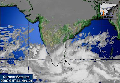
Going by latest satellite pic and LONG range numeric model...

More rain to come.
Lot's of moisture in south-bay.
More cloud activity can be seen.
And importantly a long range model shows a SUPER cyclone near tamilnadu or south-central bay.
2 models from 2 different website state the same thing.. take a look.
Soon we can see a swirl in BAY.


If the models prediction come true u can expect a super cyclone near TN coast
ReplyDeletesince the two cyclones of 2000 in November and December
http://www.wmo.ch/web/www/TCP/OperationPlans/TCP21-OP2005.pdf
I could not able to download the PDF.
ReplyDeleteAre u (pradeep) any way linked with WMO.int/ch.
here its the link for IMD
ReplyDeletehttp://ftp.wmo.int/pages/prog/www/tcp/documents/pdf/TD1082-TCseason2000.pdf
IMD had mentioned it as a category 4 Storm(T 5.0)
JTWC had mentioned only a strngth of Category 1
For JTWC report on those two storms
TC 03B http://metocph.nmci.navy.mil/jtwc/atcr/2000atcr/pdf/03b.pdf
TC 04B
http://metocph.nmci.navy.mil/jtwc/atcr/2000atcr/pdf/04b.pdf
Seems the predicted path of this storm will also be similar to any of those two storms
To the North East of Srilanka in the south west bay seems like an intensifying ciruclation. The IMD says this will become a cyclone.But i doubt if this could become a cyclone as its closer to the Indian landmass and that may prevent the intensification.at the max it can become a deep depression.
ReplyDeleteAnd regarding the post made earlier, i do not see anywhere that this could become a Category 4 storm. A storm of that magnitude would need a lot of time in the sea to gather strength.A category 4 storm would be devsatating anywayz
chandramouli
ReplyDeleteCurrent low pressure will concentrate into a low intensity cyclone and likely to cros near chennai acording to models
we are discusssing about a storm which is going to form about December 1 not sure wether it will affect tamil nadu. some models suggest it going to south andhra surely we will get rains from it
https://www.fnmoc.navy.mil/wxmap_cgi/cgi-bin/wxmap_loop.cgi?area=gfs_tropio&prod=prp&dtg=2008112418
Chill down guys we ll have heavy rains from this system only in coming days all models predict tat,but the cyclone u were referring is not going to affect india at all its going to myanmar by latest gfs model,lets see in the coming days but we r most likely to see heavy rains from the current lp tomoro and thereafter
ReplyDeletejohnny which model r u referring. i dont the path going anywhere to myanmar
ReplyDeletethe current system is going to concentrate into a cyclone and cross near north tamilnadu around chennai so we get very heavy falls from tomorrow. this sysstem expected to regenerate into deoression in arabian sea after crossing tamilnadu
the other big one expected to form around Dec 1st is expected to go to south andhra coast that wat the numerical models suggest
there are links posted by Weatherman and by me kindly see the models and see for urself
No pradeep long range gfs suggest tat, site is meteogroup.co.uk in tat see it and tell dont bother about this system i m telling about super cyc.. ....
ReplyDelete情色電影, aio交友愛情館, 言情小說, 愛情小說, 色情A片, 情色論壇, 色情影片, 視訊聊天室, 免費視訊聊天, 免費視訊, 視訊美女, 視訊交友, ut聊天室, 視訊聊天, 免費視訊聊天室, a片下載, av片, A漫, av dvd, av成人網, 聊天室, 成人論壇, 本土自拍, 自拍, A片,
ReplyDelete愛情公寓, 情色, 舊情人, 情色貼圖, 情色文學, 情色交友, 色情聊天室, 色情小說, 一葉情貼圖片區, 情色小說, 色情, 色情遊戲, 情色視訊, 情色電影, aio交友愛情館, 色情a片, 一夜情, 辣妹視訊, 視訊聊天室, 免費視訊聊天, 免費視訊, 視訊, 視訊美女, 美女視訊, 視訊交友, 視訊聊天, 免費視訊聊天室, 情人視訊網, 影音視訊聊天室, 視訊交友90739, 成人影片, 成人交友,
免費A片, 本土自拍, AV女優, 美女視訊, 情色交友, 免費AV, 色情網站, 辣妹視訊, 美女交友, 色情影片, 成人影片, 成人網站, A片,H漫, 18成人, 成人圖片, 成人漫畫, 情色網,