Season's total from 1st. June at Colaba now stands at 3004 mms, and 3075 mms at S'Cruz.

Tuesday, August 31, 2010
RT @AlertNet: Learning from Pakistan's tsunami from the sky http://bit.ly/bX2ZQh Pakistan Pakfloods flood climate
RT @malhotramona: @weatherofindia cloud over car pic taken on sat aug 21 view from taxi window @ 70 mph yippee http://ping.fm/lGfv2
2:30pm, Heavy showers popping out over S,central and North Rajasthan, while showers continue over S. Gujarat & Mahara .. http://ow.ly/i/3wp0
RT @malhotramona: @weatherofindia stormy weather photo from rick sat aug 21 evening w exp hwy http://ping.fm/1W8KN (21-Aug, Mumbai)
RT @rajugana: @weatherofindia, Baroda, 2.15pm, Sunny yet dark passing clouds from SW, no rain today.. a snap http://ow.ly/i/3wlV
12pm, Heavy showers along Gujarat coast, Maharastra and Karnataka coast continue ... http://ow.ly/i/3wk2
RT @Swim_Gym: Places to Visit in India During the Monsoon Season » The Palace of Leh, which was built in tradition... http://bit.ly/dgfQw9
Breaking News: IPCC's Global Warming Claims Not Based on Evidence, Enquiry Report
Everything is happening very fast. It was only two weeks ago that the foundation graph of IPCC's theory to Global Warming was proved a fraud by a new peer review study. Now an external inquiry constituted jointly by the UN and IPCC to look into the working of the IPCC has sounded the death blow to its credibility, at least what was left of it since the Climategate scandal last year.
The InterAcademy Council, an independent group of scientists representing agencies from around the world that undertook the enquiry concluded that the IPCC made alot of claims with high confidence levels when in reality they had little or no evidence for it. The enquiry advised IPCC to keep out of politics and concentrate on science!
The InterAcademy Council, an independent group of scientists representing agencies from around the world that undertook the enquiry concluded that the IPCC made alot of claims with high confidence levels when in reality they had little or no evidence for it. The enquiry advised IPCC to keep out of politics and concentrate on science!
Monday, August 30, 2010
Rains were heavy yesterday (sunday), especially in the Konkan and ghat regions. And the corrected rainfall figures for Mah. in cms:
28 Bhira
22 Karjat, Navsari
20 Matheran
19 Thane
18 Pali, Daman
16 Roha
15 Mahabaleshwar, Bhiwandi, Umargaon
14 Santacruz
13 Kalyan, Ulhasnagar, Mulsi, Jalalpur
12 Khalapur, Mahad, Vapi
11 Talasari, Murbad, Ambarnath, Uran, Panvel, Velhe, Mahudha
10 Vasai, Mangaon, Harij, Madhuban
9 TBI, Sahapur, Vikramgad, Pen, Maval, Radhanpur
Tamini 38, Dawdi 35 , Shirgaon 32 , Dungerwadi 31 , Bhira 28, Ambone23 , Lonavala (T) 20 , Lonavala(O) ,Walvan 17 each, Khopoli 14, Shirota, Bhivpuri 11 each, Khand 10, Thakurwadi, Wangaon 8 each, Koyna(N), Koyna(P) 6 each
Gujarat heavy rainfall figures (Sunday):
Navsari 220 mms, Upleta 214 mms, Umergam 154 mms, Kutiana 150 mms, Bardoli 140 mms, Jamjodhpur 133 mms, Doraji 130 mms,s, Jalapor 127 mms.
As per the ranfall pattern, in the coastal and ghats region heavy rains were due to
the "activated" off shore trough,embedded with 2 UACs. Rainfall map of Monday shows the rainfed regions.
The incursion of strong moisture laden winds, gave rise to violent thunderstorms in the interiors of the 2 states (Mah. and Guj.).
Now, I anticipate the UAC to move west, towards the Dwarka area of Gujarat,
hence 1 more day of heavy rains of this spell for Gujarat. As the UAC
moves, it should weaken the off shore trough, or in other words "take the steam off" the trough, and bring it back to a "normal'' trough strenght.
For rest of western Mah. region, a decrease in rain from Wednesday, as the moisture level drops due to the vanishing of the UACs.
As yet, I do not foresee any bay low forming till 3rd Sept at least.Possibility on 4th. However, the monsoon axis remains in its normal position.
Due to vanishing of the off shore trough in the east, a sudden decrease in rainfall for the states of T.N./Karnatak and A.P. from Tuesday, till the 3rd.
In fact rains could be very isolated rains in these regions. Chennai can get some convective rains in the afternoon/evening on Tuesday, and clearing up next 3 days.For Bangalore, just some drizzles till 3rd.Sept.
Northern region will also have subdued rains, next 3/4 days.
Sunday/Monday has measured up 200 mms at S'Cruz and 100 mms at Colaba, including 38 mms (Colaba) and 63 mms (S'Cruz) on Monday. Vagaries had estimated average 130 mms for Sunday thru Tuesday.
Lakes supplying Mumbai too had heavy rainfall: Tulsi 21, Vihar 15, Tansa 11,Vaitarna 8, U.Vaitarna 7, Bhatsa 6
From Tuesday, Mumbai rains will decrease, and drop to 15 mms range per day from Wednesday.
Tuesday should guage up about 40 mms of rain in Mumbai,with decrease in intensity towards evening.
Heavy Rainfall batters Maharashtra, Goa and Gujarat (rainfall in cm)
--------------------------------------------------------
Tamini 38, Dawdi 35 , Shirgaon 32 , Dungerwadi 31 , Bhira 28, Ambone23 , Karjat, Navsari 22 Matheran, Lonavala (T) 20 , Thane 19, Pali, Daman 18, Lonavala(O) ,Walvan 17 each, Roha 16, Mahabaleshwar, Bhiwandi, Umargaon 15, Santacruz, Khopoli 14
10am, Showers along N.Tamilnadu, Entire Andhra and heavy along Andhra coast, W.central Bay is very active now... http://ow.ly/i/3v9m
RT @bijumly: @weatherofindia Flight operations disrupted due bad weather in Calicut - http://bz2.in/YtbM
Sunday, August 29, 2010
Debate - Rainiest places in the world ... http://ow.ly/2wp0R ....>> Check out and post your comments, facts and more.
9pm, Widespread heavy showers over Madhyapradeshm Chatisgarh, All over Maharastra and N-W Andhra... . http://ow.ly/i/3uCb
RT @MarkVogan: Scots village is Britain's gloomiest town after seeing least summer sun - The Daily Record http://t.co/7EP1BzU via @AddThis
Debate - Rainiest places in the world
Source - Helium - Effie Moore Salem
Most people agree that the rainiest places on earth are Cherrapunji, India, Bosnia/Herzegovina, Australia, Colombia, in the Cameroon Mountain area of Africa, Kauia, Hawaii. Interestingly, I learned while researching that there is a difference between the rainiest places and the wettest places on earth. One would think that the water falling down would soak the soil to a point of saturation that could be called wet; but apparently not
Source - Red Orbit
Depending on the region, precipitation derives from different areas and can vary greatly. In the United Kingdom most rain is driven into the country by the south-western trade winds along the warm gulf stream currents. The western coastal regions can receive up to 40 inches of rain per year at sea level, and up to 100 inches in the mountains.
In the United States, the city of Seattle, Washington is well known for its rainy climate. However, despite its rainy climate, the city experiences less rainfall (37 inches per year) on average than New York City (46 inches per year). Seattle does have more cloudy days (201 per year) than New York City (152). The wettest city in the 48 contiguous United States is Mobile, Alabama, with an average rainfall of 67 inches per year. Alaska’s temperate rainforests of the southeast get an average of 160 inches per year.
Although Australia is the world’s driest continent, more than 300 inches of rain falls on Mount Bellendon Ker in the northeast each year. 472 inches were recorded in the year 2000. Melbourne’s climate is similar to that of Seattle, Washington in the USA, but only gets about 25 inches per year. Sydney receives an average of 48 inches of rain per year.
Cherrapunji, a town on the southern slopes of the Himalayas in Shillong, India is one of the wettest places on Earth. The average annual rainfall is about 450 inches per year. The highest recorded rainfall was 904.9 inches in one year in 1861. Although Mawsynram, Meghalaya, India has an estimated yearly rainfall of 467.4 inches, Cherrapunji is known as the wettest, as rainfall records were never supervised properly at Mawsynram. It should be noted that Cherrapunji is also considered the wettest area on Earth as most of its rainfall occurs during the monsoon seasons.
The town of Lloró, situated in Chocó, Colombia, is considered the place with the most rainfall, averaging 523.6 inches per year. Along with Cherrapunji in Asia, the town of Tutunendo in Colombia, South America is also one of the wettest on the planet. In 1974 the town recorded 86.3 feet of rainfall, the largest annual rainfall measured in Colombia. Unlike Cherrapunji, which gets most of its rain between April and September, Tutunendo receives rain throughout the year. Tutunendo has an average of 280 days of rain per year, of which 68% of the rain falls at night. Some storms in Chocó have been known to drop as much as 20 inches of rain in one day.
Source - Ratestogo
Before you venture off on vacation or even choose your destination, common sense dictates that you should consult the local weather authority. Many trips have ended in utter ruin because travelers, in their sheer innocence, were oblivious to monsoon season or the prevalence of sandstorms at a particular time of year. So call ahead. Consult an Almanac. And unless you have some specific scientific or sadistic need, avoid these precipitation-prone places. With many at over an inch a day, they clearly rank as the rainiest inhabited regions in the world.
Although the country of Bosnia and Herzegovina is devoid of coastline, save for a scant shore of the Adriatic, it nonetheless receives a fair amount of rain, most notably in Crkvica. The town in Bosnia, just northwest of Sarajevo, consistently receives the highest annual average precipitation in Europe.
Another megadiverse country, perhaps more so than any other on the planet, is Australia. With desert, mountains, ocean and tropical rainforests, the country continent is unlike any other. The area of Bellenden Ker and indeed, the mountain of the same name, is a World Heritage Rainforest zone. A short drive from the city of Cairns, the region is lush, rife with exotic plant and animal life and indeed a victim of mass precipitation.
It must be then that in some places the rain falls but it either runs off quickly - water runs from high to low when cool - or it is quickly evaporated into the atmosphere by the sun. Adding to that would be the wind currents that could divert the rain farther away from its downward thrust. How do the selected areas get nominated for the rainiest, the driest, having the longest drought and so on? It is the yearly rainfall averaged that gives them this distinction. In Tutunedo, Colombia the average rainfall is 463.4 inches. There it probably does not rain every day, but when it does it produces more water, In Mount Wai-Ali'Ali'in Kauai, Hawaii it rains on the average 350 days out of 365.
Opposite these facts are some no-rain statistics: From October 1903 to January 1918 it did not rain in Africa, Chile. That means that for fourteen years they were without rain. A similar but lesser deprivation happened in the US October 12th 1912 to November 8th, 1914 in Bagdad, California. The highest annual rainfall in Europe is Crkvica, a little town near Sarajevo in Bosnia.
Columbia is a wet country since it has much rainfall and apparently most of the rain is contained where it falls. Meteorologist explains it this way and label the phenomenon mega diverse. What that means is the country has mountains, deserts, tropical regions, steppes - flat lands amidst mountainous regions - giving it the right kind of weather for rain. In particular, Andaguya, a Colombian town that is on the equator and has an almost constant temperature year round. They get lots of rain. Yet, elsewhere in Colombia, there's not a drop to drink although they have a record rainfall. Quibdo, Columbia, a lowland area near the Panama border, a gateway between that country and South Central America has a record rainfall but has water shortages.
Cameroon, Africa, near the Cameroon Mountains averages about 400 inches of rain a year in some parts. The area is conducive to rain fall with the tropical regions, ocean, forests, grasslands, deserts and mountains. A similar situation happens in India. Meghalya has enough rainfall and is wet but it has little fit to drink. This area holds the record for the most rainfall in one year. In 1860-1861 it was over 900 inches.
Why does it rain daily in the wettest place in the world? In Mount Waialeala Kauai, Hawaii has special place for rain. It all related to geological conditions with a conical shape, is near an ocean and has the perfect trade winds that are conducive to rain. Llora Colombia has coastlines on the Pacific and Caribean Ocean is, according to weather watcher, a geologic freak with a daily 1.5 inch rainfall. It holds the honor of being the world's wettest place.
Source - Helium - Susan Smalls
You would expect the rainforest to be one of the rainiest places of the world, but it falls far behind in its average rainfalls. The rainforest minimally receives between 68 and 78 inches of rain a year, while the rainiest places all receive well over 400 inches per year. Perhaps they should rename the rainforests as dryforests in comparison to these wetlands.
The actual rainiest place in the world is arguable. It depends on what factors you take into consideration. Should the rainiest place be the one with the highest average rainfall or should it be the city with the most rainy days? The following three places have all claimed to be the rainiest place in the world, so I'll give you their statistics and facts and let you decide depending on which factors you think should be taken into consideration.
Cherrapunji holds two Guinness World Records relating to rainfall. The first one is the highest rainfall in one year, which was 904.9 inches between August 1860 and July 1861. It also holds the record for the highest rainfall within one month, which was 366 inches in July 1861. On average, it rains about 450 inches a year in Cherrapunji, most of which falls during the monsoon season of their winter months. The immense rainfall of Cherrapunji is caused primarily by the Khasi Hills. The monsoon clouds fly into the town from the Bay of Bengal, and the Khasi Hills then break up and condense the clouds, which leads to the high rainfall.
Mawsynram is located only 9 kilometers west of Cherrapunji, so it shares a similar climate. Here, it rains about 472 inches in an average year, but once again, the majority of this rainfall comes during the monsoon season. The Khasi Hills is what causes it to rain so much in Mawsynram as well, and the continual uplift of air over the hills makes the rainfall continuous during the monsoon season. One problem with Mawsynram is that it does not have its own meteorological office. Because of this, it is hard to obtain official records to prove that it is one of the rainiest cities, so Cherrapunji is often considered wetter than Mawsynram.
Mount Waialeale is clearly not a place you would want to honeymoon, since it rains up to 350 days a year here. In the average year, there is 467 inches of rainfall, but it is a much more consistent rain than the two cities in India. It is definitely the rainiest place in the United States, but it also claims to be the rainiest place in the world. The rain here is caused by the location and shape of the island. Because of where it is located, it is more exposed to frontal systems in the Pacific Ocean during winter. The island also has a circular shape, which allows all sides to be hit by clouds of moisture and moisture itself. Mount Waialeale is also known for its steep cliffs, which cause clouds to rapidly rise and then drop a lot of rain in one area.
As these three places battle it out for the rainiest place in the world, here are a few other rainy spots:
- Tutunendo, Columbia
- Hilo, Hawaii
- Crkvica, Bosnia
- Quibdo, Columbia
- Llora, Columbia
- Debundscha, Cameroon
Source - Red Orbit
Depending on the region, precipitation derives from different areas and can vary greatly. In the United Kingdom most rain is driven into the country by the south-western trade winds along the warm gulf stream currents. The western coastal regions can receive up to 40 inches of rain per year at sea level, and up to 100 inches in the mountains.In the United States, the city of Seattle, Washington is well known for its rainy climate. However, despite its rainy climate, the city experiences less rainfall (37 inches per year) on average than New York City (46 inches per year). Seattle does have more cloudy days (201 per year) than New York City (152). The wettest city in the 48 contiguous United States is Mobile, Alabama, with an average rainfall of 67 inches per year. Alaska’s temperate rainforests of the southeast get an average of 160 inches per year.
Although Australia is the world’s driest continent, more than 300 inches of rain falls on Mount Bellendon Ker in the northeast each year. 472 inches were recorded in the year 2000. Melbourne’s climate is similar to that of Seattle, Washington in the USA, but only gets about 25 inches per year. Sydney receives an average of 48 inches of rain per year.
Cherrapunji, a town on the southern slopes of the Himalayas in Shillong, India is one of the wettest places on Earth. The average annual rainfall is about 450 inches per year. The highest recorded rainfall was 904.9 inches in one year in 1861. Although Mawsynram, Meghalaya, India has an estimated yearly rainfall of 467.4 inches, Cherrapunji is known as the wettest, as rainfall records were never supervised properly at Mawsynram. It should be noted that Cherrapunji is also considered the wettest area on Earth as most of its rainfall occurs during the monsoon seasons.
The town of Lloró, situated in Chocó, Colombia, is considered the place with the most rainfall, averaging 523.6 inches per year. Along with Cherrapunji in Asia, the town of Tutunendo in Colombia, South America is also one of the wettest on the planet. In 1974 the town recorded 86.3 feet of rainfall, the largest annual rainfall measured in Colombia. Unlike Cherrapunji, which gets most of its rain between April and September, Tutunendo receives rain throughout the year. Tutunendo has an average of 280 days of rain per year, of which 68% of the rain falls at night. Some storms in Chocó have been known to drop as much as 20 inches of rain in one day.
Source - Ratestogo
Before you venture off on vacation or even choose your destination, common sense dictates that you should consult the local weather authority. Many trips have ended in utter ruin because travelers, in their sheer innocence, were oblivious to monsoon season or the prevalence of sandstorms at a particular time of year. So call ahead. Consult an Almanac. And unless you have some specific scientific or sadistic need, avoid these precipitation-prone places. With many at over an inch a day, they clearly rank as the rainiest inhabited regions in the world.
Although the country of Bosnia and Herzegovina is devoid of coastline, save for a scant shore of the Adriatic, it nonetheless receives a fair amount of rain, most notably in Crkvica. The town in Bosnia, just northwest of Sarajevo, consistently receives the highest annual average precipitation in Europe.
Another megadiverse country, perhaps more so than any other on the planet, is Australia. With desert, mountains, ocean and tropical rainforests, the country continent is unlike any other. The area of Bellenden Ker and indeed, the mountain of the same name, is a World Heritage Rainforest zone. A short drive from the city of Cairns, the region is lush, rife with exotic plant and animal life and indeed a victim of mass precipitation.
Colombia proves to be wet all over once again with the town of Quibdo. Over 100,000 people live in the capital of the Choco Department, as the national divisions are known as. On the border of Panama and indeed, the gateway between South and Central America, the department and town receive some of the most zany weather in Colombia. Unfortunate because in addition – or perhaps because of which – Quidibo has some of the worst social conditions and economic track records in the country. In point of fact, despite record rainfall every year, the lowland town still manages to suffer from water shortages.
Cameroon has a reputation for being one of the most exotic and beautiful nations in Africa. Indeed, it encompasses the principal features of the continent on a small scale, with hyper diversity in a region about the size of California. As a result of course, parts of Cameroon receive super heavy rainfall. This tends to be the case when you have ocean coastline, tropical forests, grasslands, deserts and mountains within close proximity to each other. At the base of Mount Cameroon and within plain view of the Bight of Biafra, Debundscha receives over 400 inches of rain a year.
Another region with rainfall levels well above 400 inches, Cherrapunji shares another notorious distinction with other wet areas. In utter bewilderment and stark contrast to the weather, the town in the state of Meghalya confronts epic water shortage problems. Geography conspires to make Cherrapunji so wet and also devoid of potable water by the same token. At the confluence of the Kashi Hills and Bay of Bengal, the town receives both north and south monsoon showers that pound the area in a flash, only to flood down the plains of Bangladesh. No suprise then that Cherrapunji holds the record for most rainfall in one year at over 900 inches back in 1860-61. Another village in the Kashi Hills in the state of Meghalya, Mawsynram proves once again that India is a complex and diverse country. A quick drive from Cherrapunji, the town records indicate more annual rainfall, although disputes about data accuracy have been rife as both regions fight for rainfall supremacy. Whatever the case may be, Mawsynram appears to have a more favorable – or is that cursed? – position in terms of proximity to the Bay of Bengal and steep incline of the Kashi Hills, which allows humid, moist air to ascend and in turn, blanket the area with rain.Although not exactly a residential area, the region around Mount Waialeale and indeed the summit, receives a ton of precipitation on a habitual basis. Tourism officials in Hawaii love to boast that this is the wettest place on the planet, although some in India and Colombia take issue with the claim. Whatever the case may be, the rainfall in Kauai is notable for the fact that it occurs with such daily regularity. Mount Waialeale bears the brunt of the precipitation because of a conical shape and pure geographical position relative to the ocean and trade winds. Although open to tourism, there are obvious physical impediments here due to the amount of rain that falls every day. In other words, the ground is super wet.
The town and municipality of Lloro is another area within the Choco Department of Colombia prone to rain. A lot of rain. With coastlines on the Pacific and Caribbean, unique in the country, the area is an ecological freak of sorts and as a result, the victim of zany phenomena. Average annual precipitation in the town of Lloro is 523.6 inches, which ranks it first in terms of wet world zones. With over 7,000 inhabitants, one has to wonder how people here cope with almost 1.5 inches of rain a day.
Source - Dandantheweatherman
Mount Wai-‘ale-‘ale, Kauai, one of the Hawaiian islands - the weather station here is 1569 metres high and records on average 13,000mm to 11,684mm rain per year, depending on which source you believe. Either way this is really wet!!!!! Rain falls on between 335 and 360 days per year, again depending on which source you believe. Nearby sea level sites, meanwhile, record around 500mm rain per year.
As you can see, sources vary considerably as to how much rain falls here. Bodin (1978) quotes 11,684mm per year figure as being the 1912-45 average, an average that quite possibly will have changed since then, whilst The National Climatic Data Center quotes this figure as a 30 year average there, but fails to mention which 30 period was covered. The Weather Network and The Guiness Book of Weather Records (Holford 1977) quotes 11,455mm rain per year, whilst Ahrens (2000) quotes 11,680mm as the average annual rainfall at Mount Wai-'ale-'ale and Kroll (1995) claims 13,000mm falls there.
Similarly, The Weather Network and the Guiness Book of Weather Records quote 335 days with rain here whilst Simons (1996) suggests that rain falls on an incredible 360 days per year here. Nice.
Mount Tutenendo, Columbia - records 11,770mm to 12,045mm rain per year, again depending on which source you choose to believe (Simons 1996, Focus Magazine 1997), and there's just 275mm difference between sources.
Lloro, Columbia - estimated 13,299mm rain per year (Raikhel 2000). According to The National Climatic Data Center this is an estimated amount and in fact Quibdo in Columbia, which is at a lower altitude than Lloro, is with an average annual rainfall of 8,991.6mm rain South America's wettest place.
Cherrapunji,north-eastern India - was thought for many years to be the wettest place in the world. Here 10,820mm rain (Holford 1977) falls on average in a year, well short of the amounts that fall at the other contenders. Unlike Hawaii and Columbia where the rain falls throughout the whole year, Cherrapunji gets most of its rain during the 'south-west monsoon', or wet season, between June and August. Cherrapunji does hold the record for the wettest month on record, recording 9,296mm in July 1861. Actually, between 1860 and 1862 Cherrapunji was incredibly wet; between August 1st 1860 and July 31st 1861 (which overlaps parts of 2 wet seasons) 26,467mm rain fell. In the calender year 1861 22,987mm rain fell, of which 22,454 fell between April and September.
Mawsynram, India - is quoted by the The National Climatic Data Center as having an annual average rainfall of 11,871mm and 11,877mm by BBC Weather, more than any other contender except Lloro in Columbia. Mawsynram is just a few kilometres away from Cherrapunji.

Summarising 28th August rainfall:
Mostly around the active vortex (UAC), and vigorous in Gujarat.
Some of the heaviest falls in cms.in Gujarat, West Mah. region as on 29th. morning:
Belapur (Thane) 12.7, Roha, Mahabaleshwar 11.9, Sidhpur 8.2, Harnai 8.0, Alibag 7.0, Panvel, Soegaon - 11 each, Srirampur, Kalyan, Vaduj - 10 each, Mahad, Tala, Harnai, Mandangad, Ulhasnagar - 8 each, Alibag, Bhira, Mangaon, Pali, Mhasala, Lanja, Thane, Ambarnath - 7 each.
Now, the current UAC, may linger around the North Mah.coast/South Gujarat coast till Tuesday. With this, I see rainfall continuing around this areas till Tuesday. Heaviest falls will be in the core of the UAC. So, in a way, I feel some heaviest rains could be expected in the Saurashtra areas and North Mah.coasts, but n
orth of Mumbai.
South Gujarat shoulds get heavy rains on Monday and Tuesday.

For a brief look at the MJO situation, I directly quote from the Australian Buraeu: ""The MJO has displayed generally erratic behaviour, and has had perhaps the greatest influence on weather across southern Asia. Longer term, one would expect to see redevelopment of the MJO in the western Indian Ocean around early to mid-September. If this scenario were to play out, we would expect the increased risk of a reinvigoration of the Indian Monsoon, and increased potential for tropical cyclone development in the region".
Monsoon is in active phase as can be seen from the Indian Monsoon Index in the chart below which shows above normal activity for the next two weeks:
ECMWRF forecasts another fresh UAC forming North of Mumbai on the 1st. of September,

tracking Northwards into Saurashtra coast, and fizzling out the very next day (2nd.Sept).
IMD sees a low in the bay by the 31st. I am not too optimistic on this low, not around this date at least. Maybe a bit later, after the 4th. Sept. That's my reading of events.
I trust this Map of NCEP/GFS forecast to show the accumalated rainfall till 3rd. Sept.
Saturday, August 28, 2010
Leh Cloudburst: What caused it? The Most Plausible Theory

There are many presumptive theories floating around on what triggered the Leh Cloudburst. Some are on the lines of conspiracy theories like those attributing it to Chinese targeting the country with their weapon modification program. Others sound seemingly outright outlandish being attributed to UFO activities. Still there are others blatantly anti-Green, accusing massive reforestation and afforestation drives over the decades as being responsible for the disaster.
Some simply end up stirring a controversy, like those blaming the disaster on on global warming. The remaining theories suggest the disaster was caused by natural climatic phenomena. However, these still fall short of offering a complete synoptic explanation of what forces actually caused the strong updraft and downdraft that led to the cloudburst in the first place.
If we need to crack the Leh Cloudburst in order to adequately and scientifically explain it, then we must identify what forces were behind both the strong updraft and downdraft. We examined seven major theories in attempt to understand which among them appeared most plausible.
Read more:
http://devconsultancygroup.blogspot.com/2010/08/leh-cloudburst-what-caused-it-most.html
6pm, Showers again over Chatisgarh, Orissa, N & S. Andhra, S & S-E Karnataka and over N-W & central Tamilnadu... http://ow.ly/i/3teq
Cloud Motion Vector
 This latest cloud motion vector depicts the movement of clouds along the wind. It indicated the strength of Wind at Tibet. It may be inferred that North Coastal AP, Orissa Coast, South Bihar and to some extend South AP and North Coastal districts of TN may get rainfall.
[Courtesy: IMD CMV imagery]
Tibetian High strengthening


Tibetian High is strengthening. Upper level winds from this high drags the cloud in NEly / Easterly direction along the path of High Pressure winds. And clouds are forming in middle tropospheric level [say at 500 hPa level] and these clouds were dragged along the upper air wind originating from High Pressure in Tibet. The strong lower level SWM winds above 15 Degree latitude becomes higher level easterly / NEly and becomes divergence.
It has been ascertained from the previous satellite imagery during last week [ from 23.08.2010 to 26.08.2010.] That is why NE states are NOT getting rainfall and Capital Delhi was getting unusual rainfall in Aug.
This is one sort of interpretation. Please comment on it.
Friday, August 27, 2010
RT @ibtimesecon: Monsoon across India till August 2010, its impact: India has received a quantum 62.52 cm rainfall ... http://bit.ly/cNRYRI
3:30pm, Heavy showers for Gujarat, N. Uttarpradesh and scattered over Madhya pradesh ... http://ow.ly/i/3rGi
RT @emkay456: AccuWeather.com - Jim Andrews | South West Monsoon Heating Up? http://t.co/vDkSq0N via @AddThis
RT @wxchannel: Hurricane Danielle has strengthened to Category 4 status (135 mph winds). Latest maps: http://wxch.nl/aFBaSx
Monsoon deficit narrows down to 2%
The all-India rainfall deficit has narrowed down to two per cent as on Wednesday (August 25), solely attributed to the lean patch in six meteorological sub-divisions in East and Northeast India.
Of these, East Madhya Pradesh and Chhattisgarh have even chances for getting into the ‘normal' category (between +20 and -20 per cent) as defined by India Meteorological Department (IMD) based on expected rainfall trends in the short term.
East Uttar Pradesh (-28 per cent) and Assam and Meghalaya (-32 per cent) also might fancy the chances of making some delayed gains, going forward.
But it may not be that easy for Jharkhand (-45 per cent) and Gangetic West Bengal (-32 per cent).
These two Met subdivisions may find themselves carrying the legacy deficit through the end of the season, as international models have been predicting.
Orissa and West Madhya Pradesh (-18 per cent each) in Central and East-central India have barely managed to make the grade as on Wednesday.
Indicative forecasts about below normal precipitation for Central and East-central India were available even as the season began this year.
Parts of Central India have managed to hold their ends up as on date.
SURPLUS IN SOUTH
As expected, Southeast India and parts of West-central peninsula have been making significant gains, a trend that is expected to sustain during the rest of the season as well.
Tamil Nadu, Rayalaseema, North Interior Karnataka, Coastal Andhra Pradesh,
Telengana and Marathwada are all in the positive territory with South Interior Karnataka just about making the grade.
To the north, Saurashtra and Kutch, West Rajasthan and Jammu and Kashmir have been the major beneficiaries of the rainfall bounty inspired in part by friendly La Nina conditions in the East Equatorial Pacific.
The western and northwestern regions are expected to witness continued wet weather even in September when the monsoon normally starts withdrawing from the region.
Meanwhile on Thursday, the Chennai Met Office said that the monsoon has been vigorous over Coastal Andhra Pradesh and Telangana and active over Rayalaseema and Karnataka during the 24 hours ending in the morning.
WIDESPREAD RAIN
Rainfall occurred at most places over Andhra Pradesh, Kerala, Lakshadweep, Coastal and North Interior Karnataka and at many places over South Interior Karnataka during this period.
Only isolated rainfall occurred over Tamil Nadu.
Elsewhere, widespread rainfall has been reported from Southwest Jammu and Kashmir, Uttarkhand, Madhya Pradesh and the West Coast, an update from the IMD said.
It was fairly widespread over the Northeastern States and the remaining parts of peninsular India except Tamil Nadu, Lakshadweep and Andaman and Nicobar Islands.
A warning valid for the next two days said that isolated heavy to very heavy rainfall would occur over Konkan, Goa, Coastal Karnataka and Kerala.
Isolated heavy rainfall has been forecast over Assam, Meghalaya, Madhya Maharashtra, Marathwada, North Interior Karnataka, South Gujarat, Lakshadweep and the Andaman and Nicobar Islands during this period.
Meanwhile, the US National Centres for Environmental Prediction (NCEP) sees the possibility of a low-pressure area spinning up over the Head Bay of Bengal by this weekend.
If this were to happen, this would be the first one to form over this ‘sweet spot,' the time lag to which is being blamed for the erratic monsoon behaviour in the East and Northeast, and even in the Northwest in the initial stages.
A strange kind of scientific explanation for Leh cloudburst
Based on a detailed analysis of weather data of the last five years in Leh, scientists have attributed the recent cloudburst in the region to prolonged winters which may be due to climate change.
“After going through the sequence of events of the weather that led to the cloudburst on August 6, it has been reinforced that the catastrophe was due to prolonged winters being witnessed in the region,” a source at the Leh-based Defence Institute for High Altitude Research (DIHAR) told PTI.
The analysis by the research institute under the Defence Ministry was done to look into the reasons that triggered the cloudburst in the Leh region on Ladakh, which is usually considered unnatural because it is a rain shadow area.
On condition of anonymity, the source said at a recent meeting on “Evaluation of climate change in Ladakh sector and causes of Cloudburst in Leh,” the scientists at DIHAR had analysed the weather data of the last five years in terms of monthly temperature, rainfall, humidity and snowfall.
The study indicated that increased temperature and hot summers in the plains lead to increased evaporation and subsequent cloud formation in the hills. “This in turn, led to increased duration of snowfall in Ladakh when compared to previous years.
“The winters in Ladakh were found to be prolonged,” the experts concluded though they felt the phenomenon could not be directly associated with climate change given the short range of data.
The region was witnessing unusual phenomenon of bright sunshine in June and July causing melting of snow and high relative humidity (72 per cent) as compared to previous years (50 per cent), the source said. Tracing the change in weather on the basis of the data available, the source pointed out “since snow absorbed the latent heat also, the monthly maximum and minimum temperature remained low and did not shoot up as compared to previous years (2006).
“The low temperature and high relative humidity lead to formation of dense low clouds in the valley. Since the vapour content in the clouds were high and on trying to cross the glaciers, the vapours further condensed.
“The clouds could not retain the water droplets that lead to the cloudburst. Since the rainfall was absent on August 3, 4 and 5 and was negligible on August 7, 8, and 9, the theory of occurrence of a cloudburst in Leh due to prolonged winters may be reinforced,” the meeting said on the sequence of event.
The cloudburst, which led to flash floods and mudslides, claimed about 180 lives and injured about 400 people besides causing widespread damage to public and private property.
The Defence establishment has also initiated research towards preventing soil erosion in case of heavy rains in the area in future in view of climate change.
Taken from www.allvoices.com
Posted by Rajan Alexander
11:30am, Showers along Gujarat coast, Maharastra coast, N-E Andhra and Orissa coast... http://ow.ly/i/3ruS
RT @MouthShut_com: 5/5 Review on Lonavla by reemasolanki : Monsoon famous picnic spot lonavala & Kh - http://ow.ly/2vzo6
Thursday, August 26, 2010
The present Low & circulation is expected to cross into N-E Andhra in another 24 hrs... http://ow.ly/i/3qgP
2pm, Heavy formations along N. Andhra coast, Orissa... and over E. Arabian sea... S-W Coast is getting sharp showers.. http://ow.ly/i/3qgx
W.central Bay Low is now positioned along Andhra coast... http://ow.ly/i/3qgr ... here's the latest sat shot of that.. http://ow.ly/i/3qgx

Rains decreasing in T.N. and North, increasing in West:
The system, low, in the bay, is now persisting in the area, off the A.P. coast, and as anticipated, is lingering in the region. Having moved a bit North, and at 1000 mb (as per IMD) today, it should now cross the coast (on the 26th.) and move inland into Rayalseema and M.P. areas.
The monsoon axis is now forked, one branch towards the north-east, and one towards the centre of the bay low.The system will move along th
 e axis corridor.
The best possible estimate of its track and strength,I feel,is shown in the NGP forecast, and will move, and fizzle out approximately as per the diagram put up.
Now onwards, I can safely visualise a decrease in rains in the drenched Northern belt, including Delhi and Haryana, already reeling under the swollen Yamuna. A major relief for the hill states of H.P.and Utteranchal which have witnessed very heavy rains and landslides last week. As the low fizzles out, by the 28th, a decrease in precipitation may also be seen in the central regions.
And, a clearing up of the T.N. and south coastal A.P. is seen from 28th, with almost clear skies for Chennai, as the pressure at MSL increases forming a vertical velocity of +10 in the region.
Then onwards, it will be the interior Maharashtra, coastal Karnataka, Goa, Konkan and eastern areas of Gujarat which will get an increased precipitation. From Saturday, it may be possible that rains will increase in these regions, and last till Monday. This enhancement in rains will be a result of an upper air low at 850 hpa, which will travel west as a pulse and get embedded (vortex) by Sunday, in the "livened up" off shore trough.
From Saturday thru Tuesday, good rains ranging from 50-150 mms could be expected in coastal Karnataka/Goa/Konkan and south coastal Gujarat.
Early next week, from 1st to 3rd. September, I estimate light rainfall travelling the south Sindh coast, with not much threat inland.
Mumbai: Rains Coming back by Saturday/Sunday. Friday: Cloudy with heavy showers sparsed in the day, with day's rainfall around 20-25 mms. (Average rain on Wednesday was 30 mms). Same intensity on Saturday, but heavier falls on late night Saturday. As a vortex forms, an increase in rain intensity from Sunday thru Tuesday, with around 130 mms of rain accumalating on these 3 days. Monday/Tuesday, of the days will be particularly heavy, and windy. A reminder that monsoon is still very much there, and an answer to FAQs.
Wednesday, August 25, 2010
Rainfall around Chennai from 01.01.10 – 25.08.10
- CHOLAVARAM – 93.5 cm
- REDHILLS – 89.1 cm
- PONNERI - 85.0 cm
- TAMARAIPAKKAM – 83.7 cm
- KORATTUR – 70.6 cm
- NUNGAMBAKKAM – 70.4 cm
- POONAMALEE - 67.7 cm
- MEENAMBAKKAM – 61.4 cm
- CHEMBARAM BAKKAM - 60.6 cm
- POONDI – 59.8 cm
- TADA - 54.0 cm
- MARINA – 53.4 cm
- SRIPERUMBUDUR - 53.1 cm
- GUINDY – 50.5 cm
- TAMBARAM - 47.6 cm
RT @wunderground: Hurricane Danielle is near 19.6N 52.3W and is moving WNW at 17 mph. http://wxug.us/46hu
5:30pm, Showers over entire Andhra, Widespread showers over S-W Coast, Central & N-E Madhya pradesh, Chatisgarh... http://ow.ly/i/3po1
12pm, Heavy monsoon showers along Maharastra coast and Karnataka coast ... Showers S. Andhra coast .. http://ow.ly/i/3p2p
This is the LOW along S. Andhra coast over Bay & this is why N. Tamilnadu and Andhra coast are getting heavy showers... http://ow.ly/i/3p2b
From Thursday evening, the rains will cease for N. Tamilnadu and S. Andhra ... while S-W coast will get heavy showers.. http://ow.ly/i/3p1W
Today, heavy showers forecast for N. Tamilnadu coast and S. Andhra coast, N. kerala and Coastal Karnataka,,, http://ow.ly/i/3p1S
Heavier rains forecast next week
The Australian Bureau of Meteorology (BoM) has said that the next active phase of the Madden-Julian Oscillation (MJO) wave would develop over West Indian Ocean from early to mid-September.
The MJO wave travels west to east periodically over the Indian Ocean and has been known to have a catalytic impact on prevailing weather over ground, especially during the monsoon.
MONSOON VIGOUR
If the aforementioned scenario were to play out, the BoM expects to see the Indian monsoon getting re-invigorated with increased potential for tropical cyclone development in the region.
The European Centre for Medium-Range Weather Forecasts (ECMWF) tends to support this outlook signalling fresh convergence of flows over the South Peninsula from August 30 (Monday next).
The ECMWF sees the possibility of development of a follow-up low-pressure area (aside of the prevailing one in West-central Bay of Bengal basin) and at least two tropical storms over the Northwest Pacific during this period.
According to the BoM, since May, the MJO wave has displayed generally erratic behaviour, and has had perhaps the greatest influence on weather across southern Asia.
PAK FLOODS
An active burst at the beginning of the month produced heavy rainfall across Pakistan and Afghanistan, which, in association with rare meteorological phenomena on show in the high northern latitudes, triggered devastating floods in the region.
Over the past week, the MJO has begun to progress into the Maritime Continent (Southeast Asian region comprising islands, peninsulas and shallow seas) for the first time since May, and has contributed to the development of a named tropical storm ‘Mindulle' in the South China Sea.
The London-based Tropical Storm Risk Group indicated on Tuesday that the ‘Mindulle' might be approaching Vietnam soon for a landfall.
LIKELY REMNANT
It would now be interesting to watch whether a remnant of the westward-bound storm would set up activity over the North Bay of Bengal.
The seas here have warmed up beyond 30 deg Celsius to being able to sustain a low-pressure area. In fact, the sea-surface temperature (SST) off the Andhra Pradesh coast measured 32 deg Celsius on Tuesday. Meanwhile, a ‘low' has been persisting overnight over the West-central Bay on Tuesday.
According to the Noida-based National Centre for Medium-Range Weather Forecasts (NCMWRF), the ‘low' could persuade the monsoon trough to shift south closer to its normal position during a productive monsoon phase.
This would also mean that the Central and East-central India could be bracing for another active monsoon session over the next two days.
Meanwhile on Tuesday, the Pakistan Met Department issued fresh flood alert for rivers Sutlej and Ravi even as scattered rains have been forecast for the northern provinces from an itinerant westerly trough.
The International Research Institute (IRI) for Climate and Society at Columbia University in updated forecasts based on initial conditions obtaining on Sunday has put the northwestern regions of Pakistan and adjoining India under rain watch during the rest of this week.
Rajasthan, Northwest Madhya Pradesh and parts of Gujarat also are in the list of regions where IRI sees chances for moderate to heavy rain activity.
India Meteorological Department (IMD) said in an update that widespread overnight rainfall was reported from Sub-Himalayan West Bengal and Sikkim.
It was fairly widespread over Uttarkhand, Haryana, Uttar Pradesh, the Northeastern States, Rayalaseema, the West Coast, South Interior Karnataka, North Tamil Nadu and the Andaman and Nicobar Islands.
Satellite pictures showed convective (rain-bearing) clouds over parts of Uttarkhand, Uttar Pradesh, Bihar, Jharkhand, West Bengal, Chhattisgarh, Andhra Pradesh, South Karnataka, Kerala, Tamil Nadu, South and East-central Bay, Andaman Sea and Southeast Arabian Sea.
A warning valid for the next two days said that isolated heavy to very heavy rainfall is likely over Uttarkhand, East Uttar Pradesh, Bihar, Sub-Himalayan West Bengal, Sikkim, Assam, Meghalaya, Arunachal Pradesh, Coastal and South Interior Karnataka, Kerala, Tamil Nadu, Coastal Andhra Pradesh and Andaman and Nicobar Islands.
The IMD forecast signalled isolated heavy to very heavy rainfall on Wednesday for the Jammu Division of Jammu and Kashmir, Himachal Pradesh, Haryana, Chandigarh, Delhi and West Uttar Pradesh.
Tropical Storm "Mindulle"

Tropical Storm Mindulle hovered over the South China Sea, off the coast of Vietnam, in late August 2010. On August 23, 2010, the U.S. Navy’s Joint Typhoon Warning Center (JTWC) reported that Mindulle had maximum sustained winds of 50 knots (95 kilometers per hour) with gusts up to 65 knots (120 kilometers per hour). The JTWC stated that Mindulle was located roughly 135 nautical miles (250 kilometers) south-southwest of Hainan, and was expected to continue its path toward the west-northwest.
The Moderate Resolution Imaging Spectroradiometer (MODIS) on NASA’s Terra satellite captured this natural-color image on August 23. Mindulle forms a giant swirl spanning hundreds of kilometers over the South China Sea, and clouds extend as far inland as Thailand.
The projected storm track released by the JTWC showed Mindulle making landfall along the coast of northern Vietnam late August 24 or early August 25, and diminishing over land.
Tuesday, August 24, 2010
The low in the bay finally appeared today,24th. August, and, is off the North T.N./ A.P. coast. At 1000 mb, it is persisiting, and lingering in the region since the last 24 hrs.From tomorrow, 25th.it should strenghten and move towards the A.P. coast. I estimate the system to cross the coast by the 26th, and at 998 mb pressure.
The WD25, mentioned in the "vagaries" has entered India from the west, as expected, and aligned itself with the monsoon axis. Resultantly, the Northern regions continued to
recieve heavy rains from the 23rd. and today's satellite image shows excessive clouding in
the U.P. and Bihar regions.
Today,the WD having moved away, now may not impact the direction of the bay low.The bay system should now take the axis corridor. The axis has now joined into the low as its eastern end. On crossing land, moving across A.P. and into M.P, it should precipitate rains along its path, and thru Vidharbha, and Northern Maharashtra, on 26th/27th August.
By the 27th.,it should fizzle out. BUT, a pulse emerging from the system, at 700/850 hpa,
should move ahead, and culminate into a vortex, or maybe a low, off the North Maharashtra/Gujarat coast around the 28th. Simultaneously, the off shore trough off the west coast will "liven up". Most models are in agreement.
Consequently, a much heavier rainfall regime should commence along the west co
ast. The rainfall areas will be from Karnataka coast/ Konkan and South Gujarat coast.
Some models are showing a very deep vortex, within the trough, and linked to the projected low which may form off the Gujarat/North Maharashtra coast. If it materialises, North Maharashtra coast (North of Mumbai) and Gujarat coast could recieve extremely heavy rains, upto 300/350 mms, around 28th. Saturday/ 29th. Sunday. The affected region, as of estimates now, would be North of Mumbai.Its a bit early to forecast t
oday, and we shall monitor this on daily basis.
To summarise, I would estimate precipitation as per these 2 weekly accumalated weekly rainfall maps of the next 2 weeks from NCEP/GFS. Of all the various models and estimates, I feel, these m
aps summarises the system's most probable rainfall track.


.
Mumbai: On reading the above, I feel, Mumbai should start with rains again f
rom Friday/Saturday
Friday: Frequent showers. Cloudy and overcast. Rainfall upto 20 mms.
*Saturday: Rainy condtions, and by evening frequency of rains increasing. Squally weather, with about 50 mms of rain, more at night.
*Sunday: Overcast. Windy and rainy. Heavy showers, with flooding. Rainfall on Sunday could be upto 100 mms.
*Saturday and Sunday forecast are subject to revision. Depends on the exact location of the Arabian Sea low, and the vortex, to be formed. As mentioned above, will be monitored daily, as important for Mumbai weather.
Leh got 240mm in 24 hrs on the fateful day - GSI

On the night of 5th and 6th August 2010, between 00:00 hrs and 00:30 hrs, intensive rainfall followed by massive cloudburst in high altitude terrain of Leh (3505m), triggered numerous debris flows, mud flows (earth spreads) and sand flows. These widespread, composite flows in the over saturated slope forming materials caused 182 deaths including that of 3 foreign tourists, damaged 607 houses, breached all major communication networks to Leh town besides inflicting an unaccountable loss of livestock and agriculture fields. The disaster caused severe damage to the settlements in parts of Leh town, Sabu village, Choklamsar, Leh airport area, Nimu, Ney and Bazgo area around the town.
The Deputy Director General, Geological Survey of India, Northern Region, Lucknow nominated S/Sh. VK.Sharma, Sr. Geologist, Ajay Kumar and Pankaj Kumar Geologists to investigate the affected area. The GSI team visited the area from 11th August to 16th August, 2010. Trans Himalayan region, known for its cold and desert type climate owing to scanty rainfall and high sun radiations, had never witnessed such a disastrous scenario since the recorded historical times, notwithstanding the fact that cloudbursts occur frequently in the higher reaches of the mountains.
 The Leh region represents a broad U shaped glacial valley of Indus river sandwiched between the lofty high ranges of Ladakh in the north and Zanskar in the south. Huge piedmont fans, river terraces, recent flood plains with prominent point bars, lateral bars and Aeolian deposits are the major geomorphic units of the terrain. Lacustrine deposits, indicating neotectonic activity, at places, have been observed near Sputik, Phyang and Nimu localities. Geologically, the affected region is occupied by Ladakh Granitoids and Quaternary sediments of glacial, fluvio-glacial, lacustrine, alluvial and Aeolian origins.
Widespread occurrence of varied, unconsolidated Quaternary drift deposits perched over gentle to fairly steep slopes are susceptible to mass movement under conditions of heavy saturation. Unprecedented rainfall of the order of 240 mm within 24 hours on account of cloud bursts in the Leh region during 4-6 August 2010 caused excessive mass movement of drift deposits and over spilling of the banks of the streams. Huge quantities of debris charged water moved in high energy regime destroying everything in its run out path.
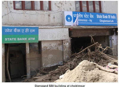 In Leh area, the damage was confined in the catchments of Shaksaling nala, flowing from an elevation 3800 m to 3410 m. The debris flow mobilized and damaged the settlements, Bus Stand building, BSNL buildings, Hospital Complex, Radio Station, etc. in its 3 km run-out distance.The Sabu nala section, located about 11 km east of Leh, was affected the most by the cloudburst. The prolonged and heavy rainfall that reportedly lasted for 30 minutes raised the water level by about 10-15 feet and triggered the movement in slope debris. Water charged with debris, wooden logs and huge blocks of granite choked the course of the nala at bridge points near villages Zong, Myek and Ayu Sabu. The village settlements, forest and agricultural fields were damaged on account of over spilling of water mixed with debris and boulders, which flowed out with an appalling velocity, resulting death of 11 persons in Sabu village. When the debris blockades at bridge points breached due to further on-gush, the debris flow spread out in the downstream commands. This phase, lasting for about 30-45 minutes, was, in fact, the major cause of devastation to Choklamsar village, ITBP Camp, Leh-Manali route, New Choklamsar market, etc. It is reported that bodies of 48 people were recovered from the debris from these areas. A pile of debris upto 4 m high was observed at Leh–Manali road near New Choklamsar village. The debris further moved and spread along the road before falling into Indus river. Typical accumulation lobes of finer fraction of debris material were observed at tail end of the flow.
  The total run out distance of the debris flow from the epicenter of the cloudburst in the Sabu nala to the tip of the debris flow was of the order of 10 km. The maximum lateral spread of debris flow has been observed to be about 2 km. The morphological dimension of the debris flow and lateral spread belies the current figures of deaths and damages in the area. Stokma nala, flowing adjacent to Stokma village, was blocked by huge boulders and wooden logs resulting in diversion of the nala course towards the right bank in a geomorphic depression /dry nala. The Druk Padma Karpo Institute, generally referred to as “Ranchoo’s School”, located within the flow direction of mud/soil/silt has been affected. The surge of mudflow entered the classrooms of the School.
The airfield of the Leh, one of the highest airports in the world, is uniquely situated in a ‘U’ shaped wide valley. The granite hills around the airport area are covered by a pile of piedmont fans, lacustrine deposits and top layer of Aeolian sand. The field area is on the fluvio-glacial deposits. The cloudbursts affected the airfield when sand /Aeolian deposits and a section of terrace spread out over the air strip, thereby hampering the air traffic, and to an extent, the rescue operations.
The natural depressions on both sides of nala and low lying dry streams, where sprawl of settlements have grown, were in general, the worst affected sites of devastation; the higherelevation of slopes were the least affected locations. The mass movement in geologically fragile Quaternary sediments under unprecedented saturated conditions was largely responsible for the devastation. The selection of sites for rehabilitation in the area should, therefore, consider the local geomorphic setting, the nature of slope forming material and potential run-out zones of mass movements.
The natural depressions on both sides of nala and low lying dry streams, where sprawl of settlements have grown, were in general, the worst affected sites of devastation; the higherelevation of slopes were the least affected locations. The mass movement in geologically fragile Quaternary sediments under unprecedented saturated conditions was largely responsible for the devastation. The selection of sites for rehabilitation in the area should, therefore, consider the local geomorphic setting, the nature of slope forming material and potential run-out zones of mass movements.
Tropical Storm Danielle

Tropical Storm Danielle formed as a tropical depression over the Atlantic Ocean on August 22, 2010. By the following day, Danielle had strengthened to a tropical Storm, and had the potential to become a hurricane by evening, the U.S. National Hurricane Center (NHC) reported.
The Moderate Resolution Imaging Spectroradiometer (MODIS) on NASA’s Terra satellite captured this natural-color image of Tropical Storm Danielle at 9:15 a.m. AST (13:15 UTC) on August 23. Danielle boasts the apostrophe shape typical of tropical storms, although it lacks a distinct eye.
At 11:00 a.m. AST on August 23, 2010, the NHC reported that Danielle had maximum sustained winds of 65 miles (100 kilometers) per hour, and was expected to strengthen further over the next 48 hours. Danielle 1,025 miles (1,650 kilometers) west of Cape Verde.
RT @DTNIndia: Above normal rainfall in Rajasthan this monsoon: Many districts of Rajasthan, including the desert regio. http://bit.ly/diY3Cb
12:30pm, Due to the Low along Tamilnadu and Andhra... S-W coast along Karnataka & Kerala are getting sharp showers... http://ow.ly/i/3nSh
12:30pm, Heavy showers along Central coastal Tamilnadu and seen marching inland ... http://ow.ly/i/3nSh
Subscribe to:
Posts (Atom)