Now (12:03 PM) we are experiencing some drizzles & a passing shower.
But good thing is it's heavily cloudy and with good rain bearing clouds forming all over North, north-east and East.
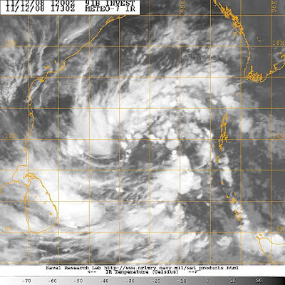
This might be the signs of things to come, because we are tracking a Fairly potential Tropical depression/Cyclone... almost parallel to Chennai.
Here is the latest tracking info from www.nrlmry.navy.mil
********************************************

THE AREA OF CONVECTION PREVIOUSLY LOCATED NEAR 10.2N 89.6E
IS NOW LOCATED NEAR 11.8N 87.5E, APPROXIMATELY 430 NM EAST OF MADRAS,
INDIA. RECENT ANIMATED INFRARED SATELLITE IMAGERY SHOWS DEEP CON-
VECTION, THAT WAS PREVIOUSLY CONFINED TO THE THE PERIPHERIES OF THE
CIRCULATION, DEVELOPING NEAR THE CENTER OF THE SLOWLY CONSOLIDATING
LOW LEVEL CIRCULATION CENTER (LLCC). THIS LLCC IS ALSO EVIDENT IN A
121105Z SSMI IMAGE. THIS DISTURBANCE LIES NEAR AN UPPER-LEVEL ANTI-
CYCLONE AXIS, IN AN AREA OF LOW TO MODERATE VERTICAL WIND SHEAR AND
FAVORABLE POLEWARD DIFFLUENCE ALOFT. MAXIMUM SUSTAINED SURFACE WINDS
ARE ESTIMATED AT 20 TO 25 KNOTS. MINIMUM SEA LEVEL PRESSURE IS EST-
IMATED TO BE NEAR 1003 MB. DUE TO THE CONSOLIDATING DEEP CONVECTION,
THE POTENTIAL FOR THE DEVELOPMENT OF A SIGNIFICANT TROPICAL CYCLONE
IN THE NEXT 24 HOURS IS UPGRADED TO FAIR.********************************************
More abt this from Jim's Accuweather.com Blog...
*********************************************
The broad mass of showers and thunderstorms is loosely organized, but shows good outflow aloft--this is essential to "close the loop" (inflow, rising, condensation and energy release, outflow, sinking) that is exhibited by any tropical storm.
My (learned?) guess is that a tropical cyclone will arise from this mass. Andhra Pradesh and northern Tamil Nadu would be the likely targets for the center of whatever becomes of this entity.
Beyond the question of cyclone/no cyclone, there is the problem of upcoming rainfall (it would be deemed "North East Monsoon" rain) over the south of India (and Sri Lanka). There is going to be some, and there will be locally heavy rain (scattered if no cyclone, focus near landfall if a cyclone).
An aspect of the upcoming rains in southern India has arisen that I had not earlier foreseen. This would be an outbreak of thunderstorms along the west coast and Western Ghats northward to at least greater Mumbai during the first part of next week. A vigorous short wave trough in the Westerlies (Western Disturbance), swinging east from the Khaleej by way of Iran, would play a part in this scenario, were it to happen.
*********************************************
