Wednesday, June 16, 2010


The pieces have fallen well in place,with the trough off the western coast of India, embedded with a vortex off North Maharashtra coast,producing the heavy rains predicted, and moving the monsoon northwards into south Gujarat and all of Maharashtra.The limit of the monsoon is seen in the 200 hpa map. Easterlies indicate the monsoon limit normally.


Some of the heavy rainfall figures of rain recorded on tuesday(day n night) are (in cms):Sangamneshwar-23,Khed-15,Dapoli-13,Chiplun-12,
Mahableshwar 14cms, Dahanu 11cms,Ratnagiri 10cms, Mumbai S'cruz 9cms and colaba 8cms
The lakes of Mumbai too recieved very good rainfall, a boon to the city:Vihar-16, Bhatsa-7, Upper Vaitarna-5, Tansa-4, Tulsi-3,Vaitarna-2.
For Mumbai,heavy rains were predicted,Monday thru Wednesday,At least a week in advance."Vagaries of the Weather" had estimated 23cms of rain Monday thru Wednesday for the city, and the actual rain recorded was20cms at colaba and 18cms at S'Cruz,till Wednesday evening.


And flooding and water logging and gusty winds was anticipated.The tall claims of the authorities have fallen like a pack of cards,in spite of the fact that flooding was expected.More than 20 low lying areas in the city were flooded knee deep, and Walls have collapsed.Landslides in Thane have led to much damage, and importantly,loss of lives.
Same old story!Forget the hoodwinking of the Shanghai story!Better would be a Venice promise,it will be easier !


The off shore trough will hang on, but the vortex off Mumbai, I expect, will cross inland. The result should be some torrential rains in North Madhya Maharashtra on Thursday.
Konkan rains will linger on till Saturday, though reduced. 
Mumbai will see the rains gradually reducing from Thursdsay, and the weekend should be comparitively drier, with about 25-30mms of rain/day.
The rest of the west coast areas will continue to get moderate rains, around 35mms/day till Sunday.


All eyes on the Northern head of the Bay now. An unusual monsoon trough of low (for this time of the season) runs along the Northern plains of india, with the eastern end dipping in the Bay. Now this "dip", is the centre of all attention, and should form into a low. 
With this formation, the monsoon's eastern branch should move along the axis of the trough, and bring the rains into Bihar and East U.P.on its way into Delhi.
Also,the south-west flow from the Arabian Sea onto the Karnataka and Konkan coasts will get a boost from this formation.


With the advancing monsoon spreading a cloud cover over the peninsula,and a W.D.covering the Nort/Northwest,the highest day temperatures have reduced to around the 40c levels.


On Wednesday,
Highest in Asia:Basrah(Iraq):50c
Highest in India:Patna:42c
Mahabaleshwar - has become cooler after the summer heat. Temp. are around 23C Max and 18C Min
FULL ... Rainfall data of 15-Jun-10... PDF ... http://ow.ly/d/4aZ
RT @AlertNet: RT @alertnetclimate: VIDEO: Swapping rice for bananas in Nepal http://bit.ly/cT9JyZ climate
RT @piyush_veere: On railway station..leaving nagpur today. And its raining pretty good here.. (6:53pm) @weatherofindia
Pondicherry - Today evening SW is having high clouds. But patcy low clouds runing fast from SE and moisture wind from SE.
Pondicherry - Recorded 3cm rain from late evening shower on 15-Jun
RT @tnewsindia: @DNA india news Monsoon is a bit late, but no worries for now, says weather office http://ow.ly/17Lgyf
5:30pm, Whole of North Bay is active .. this is into 6th day... http://ow.ly/i/25Nj
5:30pm, Fresh thunder storms over Central, N-W and S-E Bihar , N.central Bengal and E.central Maharastra .. http://ow.ly/i/25Nj
5:30pm, Heavy monsoon showers over Coastal Maharastra & Karnataka .. http://ow.ly/i/25Nj
3:30pm, Thunder storms over N. Jharkand, S-E and N-W Bihar, N-E Orissa, S-E Madhyapradesh .. http://ow.ly/i/25Js
3:30pm, Heavy showers continue along Coastal and N-W maharastra ... http://ow.ly/i/25Js
RT @JayalalTvm: hevy rain, enjoying.......Kerala rain....special one. (1:20pm)
Chennai - @PPrakash @BalaSN: .. Chance of shower is getting reduced till 9pm and only possibility is after midnight towards early morning.
Chennai - @PPrakash @BalaSN: .. now 4:23pm.. the high dead cloud cover is clearing up.. wind is from Sea.. NO low cloud formation.
Rain map of 15-Jun ... http://ow.ly/i/25IK
Chennai - A high dead thunder cell is over us now 3:31pm... Temp. touchd 33.5°C (2:32pm).. Mild Wind from E-N-E.
RT @ushahari: Eco Project at Gavi to woo more tourists to Kerala http://bit.ly/bAm27s
India's monsoon is running four to five days behind schedule and has yet to reach half of the country's territory though rains
Today : Muggy weather in Delhi, rains likely ... http://ow.ly/1Z7AP
Finnish firm may help weather forecasting during Commonwealth Games ... http://ow.ly/1Z7Ai
Mahabaleshwar recorded 137.7 mm rain in 24 hrs upto 8.30 IST Heavy rains likely to continue upto week end.
Pondicherry - 15-Jun, late evening heavy showers ... report.. http://ow.ly/1Z6Md

Pondicherry - 15-Jun, late evening heavy showers

It ir raining heavily in pondy since 9pm (15-Jun). Previously heavy wind from SW from 7pm to 7:30 and rained heavily from 7:30 to 8pm. Now pondy is like kerala(very cool).


Rain stopped now (1:44am). I think another12cms for pondy. This time it will not be on top of the table. power cut for 3.5hrs due to wind and lightning. 


As reported by Dhinagar
Showers along Kerala coast has reduced today.. it'll reduce even more from 19-Jun.
North-West may have to wait until early July for Monsoon rains... http://ow.ly/1Z6Cx

North-West may have to wait until early July for rains

A four-day lull in south-westerly flows across the South-East Arabian Sea from Saturday could delay the onset of the monsoon over parts of North-West India.
Seasonal rains should normally cover the entire land mass by June 30, but may just stop short of achieving it this time around.
This is as per updated predictions from the US National Centres for Environmental Prediction (NCEP).

WAIT UNTIL JULY
The whole of Rajasthan, north Gujarat and adjoining west Madhya Pradesh may likely find themselves waiting until early July for the onset of monsoon locally.
The lull in the flows over the Arabian Sea would have repercussions for the Bay of Bengal as well, delaying the formation of a suitably endowed ‘low' to turn around things from that end.
The ‘twin-engine' scenario wherein the monsoon catapults itself into active status powered by ‘low's on either side of the peninsula, may not unfold until June 25, according to the European Centre for Medium-Range Weather Forecasting.
A western disturbance system is tipped to cross into northwest India around that time. It would dig deep into the Arabian Sea and the Bay to activate the ‘low's.
Ahead of this, the monsoon flows are shown to resume in full strength from June 22 and peak by June 25, setting the ground for system generation.

FLOOD ALERT
The International Research Institute (IRI) for Climate and Society at Columbia University has shifted further to the north along the west coast its watch for flooding rains.
A six-day outlook until Saturday suggested above normal rains are likely for north Konkan, Mumbai, south and south-west Gujarat.
However, the IRI did not see rainfall amounts exceeding 10 to 12 cm for Mumbai any time during this period.
On Sunday, Dr Akhilesh Gupta, leading operational forecaster and Advisor to the Ministry of Science and Technology, told Business Line that it was too early to expect exceptional rains (exceeding 25 cm) for Mumbai.
The city is used to rains amounting to 10 cm during the monsoon, but torrential rains capable of throwing normal life out of gear can happen only during the latter stages when the monsoon flows “mature”.

THUNDERSHOWERS LIKELY
The NCEP precipitation outlook suggested that, despite the brief weakening of flows, thundershowers could break out occasionally along the west coast through the next week.
The convective available potential energy (CAPE) values, which indicate the relative potential for thundershowers, are the maximum around the Konkan and Gujarat.
In fact, the US Navy Operational Global Atmospheric Prediction System (Nogaps) model suggested the possibility of a ‘low' spinning up in the northeast Arabian Sea and washing ashore along the Mumbai-south Gujarat coast during the period under reference.
India Meteorological Department (IMD) said in an update on Tuesday that the northern limit of the monsoon passed through Mumbai, Aurangabad, Adilabad, Jagdalpur, Phoolbani, Keonjhargarh, Burdwan, Malda and Gangtok.
The alignment was unchanged from the previous day, the IMD added.
It warned of isolated heavy to very heavy rainfall over Madhya Maharashtra, Konkan, Goa and coastal Karnataka during the next two days.
The outlook until Friday suggested that widespread rain or thundershowers are likely over Madhya Maharashtra, Marathwada, coastal Karnataka, Konkan and Goa.
Fairly widespread rain or thundershowers may occur over Saurashtra, Gujarat, Kerala, Lakshadweep, Andaman and Nicobar Islands and the Northeastern States.
Scattered rain or thundershowers are likely over Madhya Pradesh, interior Karnataka, Andhra Pradesh, Bihar, Jharkhand and Chhattisgarh, Orissa, Vidarbha, West Bengal and Sikkim.
An intervening western disturbance would bring scattered rain or thundershowers over Jammu and Kashmir, Himachal Pradesh and Uttarkhand.
Isolated dust storm or thunderstorms may also occur over Punjab, Haryana, Delhi, Uttar Pradesh and Rajasthan.
Mumbai Heavy Rains with High Tide

Heavy rains coupled with strong winds lashed Mumbai and its suburbs on Wednesday, disrupting air and rail traffic and leading to water logging in many areas. The city received 60.77 mm , Colaba in south Mumbai received 78.6 mm and suburban Santacruz received 95.0 mm, the MET department said.

The BMC has alerted a high tide of 4.70 metres at 1521 hours on Wednesday.“Any tide above 4.5 metres is coupled with heavy rains and is a matter of concern.

On July 26, 2005, Mumbai saw unprecedented floods as 944 mm of rainfall coincided with a 4.48 m tide.
RT @myviews4life: Two-day meet on climate change begins today: 60 Vice-Chancellors from various universities ... http://tinyurl.com/35yf4j5
RT @piyush_veere: @weatherofindia - its raining in nagpur..i hope patna is wet too. - http://ping.fm/aiulQ (7:31pm, 15-Jun)
Huge thunder clouds were seen yday evening south of Chennai..they have poured in Pondy last night (15-Jun).

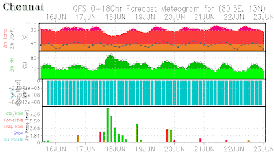
Chennai Weather Prediction

NCMWRF-T254
---------------------
35 mm from 16th to 19th with a Maximum of 25mm on 17th


GFS
------
43 mm from 17th to 20th with a Maximum of 30mm on 18th
Water levels in the six lakes that supply water to Mumbai are gradually improving due to heavy rain in the catchments in the last two days.

Vihar Lake recorded 200 mm of rainfall in the last 24 hours.
The ‘twin-engine' scenario

The lull in the flows over the Arabian Sea would have repercussions for the Bay of Bengal as well, delaying the formation of a suitably endowed ‘low' to turn around things from that end.

The ‘twin-engine' scenario wherein the monsoon catapults itself into active status powered by ‘low's on either side of the peninsula, may not unfold until June 25, according to the European Centre for Medium-Range Weather Forecasting.

A western disturbance system is tipped to cross into northwest India around that time. It would dig deep into the Arabian Sea and the Bay to activate the ‘low's. Ahead of this, the monsoon flows are shown to resume in full strength from June 22 and peak by June 25, setting the ground for system generation.

Source - Business Line - June 16