
Saturday, December 31, 2011
A strong W.D will start over N,N-W Kashmir from evening of 3-Jan .. and will continue beyond 6-Jan .. http://ow.ly/i/oM10
New year DAY showers for S. Kerala, S. Tamilnadu, S. Andhra, Chatisgarh, E. Maharastra and E, central Madhyapradesh.. http://ow.ly/i/oLYC
During early hours of 31-Dec... massive showers over S. Kerala and S. Extreme Taminladu .. http://ow.ly/8eFoF
During early hours of 31-Dec massive showers over S. Kerala and S. Extreme Taminladu
Rainfall occurred at most places over Tamil Nadu and Rayalaseema, at many places over Kerala and at a few places over Coastal Andhra Pradesh and South Interior Karnataka. Mainly dry weather prevailed over Lakshadweep and dry weather prevailed over Telangana, Costal and North Interior Karnataka.
The following stations recorded very heavy to heavy rainfall in centimetres:
Haripad (Alapuzha dt) 22, Tiruvananthapuram and Kallakurichi (Villupuram dt) 18 each, Nedumangad (Tiruvanathapuram dt) and Gingee (Villupuram dt) 16 each, Kayamkulam (Alapuzha dt) 15, Thiruvalla (Pattanamthitta dt), Sankarapuram (Villupuram dt), Mylaudy and Nagerkoil (both Kanyakumari dt) 14 each, Uthiramerur (Kanchipuram dt) and Kuzhithurai (Kanyakumari dt) 13 each, Chengannur (Alapuzha dt), Virudhachalam (Cuddalore dt), Cheyyar (Tiruvannamalai dt) 12 each, Neyyatinkara (Tiruvananthapuram dt), Mancompu (Alapuzha dt), Tozhudur (Cuddalore dt), Tirukoilur (Villupuram dt), Polur, Vanthavasi and Sathanur Dam (all Tiruvannamalai dt) 11 each, Mavelikara (Alapuzha dt), Kanchipuram, Maduranthagam (Kanchipuram dt), Puducherry airport and Arani (Tiruvannamalai dt) 10 each, Konni (Pattanamthitta dt), Kanjirapally (Kottayam dt), Kottayam, Alapuzha, Chengalpattu (Kanchipuram dt), Chembarambakkam (Tiruvallur dt), Ulundurpet (Villupuram dt) and Tiruvannamalai 9 each, Punalur, Tiruvallur, Boothapandy (Kanyakumari dt), Kanyakumari, Chengam (Tiruvannamalai dt) and Sholingur (Vellore dt) 8 each and Varkala (Tiruvananthapuram dt), Kozha (Kottayam dt), Chennai airport, Cheyyur, Kelambakkam and Sriperumpudhur (all Kanchipuram dt), Poonamalli, Ramakrishnarajupet and Tiruvalangadu (all Tiruvallur dt), Tiruttani, Sethiyathope (Cuddalore dt) and Tindivanam (Villupuram dt), Kumbakonam (Thanjavur dt), Arakonam and Kaveripakkam (both Vellore dt), Vellore, Attur (Salem dt), Coonoor, Jayamkondam (Ariyalur dt) and Padallur (Perambalur dt) 7 each.
The other chief amounts of rainfall recorded in centimetres are:
Pallipattu and Ponneri (both Tiruvallur dt), Marakanam (Villupuram dt), Valangaiman (Tiruvarur dt), Pechiparai and Thuckalay (both Kanyakumari dt), Harur (Dharmapuri dt), Yercaud, Kodaikanal, Chettikulam (Perambalur dt), Tirumangalam (Madurai dt) and Periyakulam 6 each, Peermade (Idukki dt), Poondi and Red Hills (both Tiruvallur dt), Vanur (Villupuram dt), Tiruvidaimaruthur (Thanjavur dt), Kollidam (Nagapattinam dt), Shenkottai and Thenkasi (both Tirunelveli dt), Maniyatchi (Tuticorin dt), Alangayam (Vellore dt), Tirupattur, Pappireddipatty (Dharmapuri dt), Vazhapadi (Salem dt), Erode, Ariyalur, Perambalur, Vembavur (Perambalur dt), Samayapuram (Tiruchirapalli dt) 5 each, Madheswaranmalai Hills (Chamrajnagar dt), Nellore, Tirupathi airport, Tiruvananthapuram airport, Cholavaram and Thamaraipakkam (both Tiruvallur dt), Kattumannarkoil (Cuddalore dt), Ayikudi (Tirunelveli dt), Gudiyatham, Melalathur and Walajapet (all Vellore dt), Uthangarai (Krishnagiri dt), Kumarapalayam (Namakkal dt), Thammmapatti (Salem dt), Bhavani and Gobichettiapalayam (both Erode dt), Karur and Watrap (Virudhunagar dt) 4 each, Kalingapatnam, Kavali, Perumbavur (Ernakulam dt), Idukki, Kollam, Chennai, Tambaram, Chidambaram and Srimushnam (both Cuddalore dt), Orathanadu and Papanasam (both Thanjavur dt), Kodavasal and Needamangalam (both Tiruvarur dt), Viralimalai (Pudukottai dt), Sathankulam (Tuticorin dt), Ambur and Vaniyambadi (Vellore dt), Barur (Krishnagiri dt), Mangalapuram, Sendamangalam, Tiruchengode and Rasipuram (all Namakkal dt), Namakkal, Mettur Dam and Sankaridurg (both Salem dt), Mettupalayam (Coimbatore dt), Perundurai (Erode dt), Kothagiri (Nilgiris dt), Panchapatti (Karur dt), Karur Paramathi, Lalgudi, Pullambadi and Thuraiyur (all Tiruchirapalli dt), Tiruchirapalli, Melur and Usilampatti (both Madurai dt), Andipatti and Periyar Dam (both Theni dt), Dindigul, Kamatchipuram and Nilakottai (both Dindigul dt) 3 each, Kumarakom (Kottayam dt), Thodupuzha (Idukki dt), Aryankavu (Kollam dt), DGP Office (Chennai dt), Grand Anaicut, Tirukattupalli and Tiruvaiyaru (all Thanjavur dt), Mayiladuthurai and Sirkali (both Nagapatitinam dt), Ambasamuthiram and Radhapuram (both Tirunelveli dt), Palacode (Dharmapuri dt), Penucondapuram (Krishnagiri dt), Krishnagiri, Salem, Chinna Kallar and Periyanaickenpalayam (both Coimbatore dt), Dharampuram (Tiruppur dt), Kodumudi (Erode dt), Ketti (Nilgiris dt), Uthagamandalam, Aravakurichi and Mayanur (both Karur dt), Manaparai and Thuvakudi (both Tiruchirapalli dt), Tiruchirapalli airport, Peraiyur and Sholavandhan (both Madurai dt), Bodinayakanur, Gudalur and Uthamapalayam (all Theni dt), Theni, Sivagangai, and Vedasandur (Dindigul dt) 2 each and Chintamani and Thondebhavi (both Chikkaballapura dt), Belur and Halebeedu (both Hassan dt), Kolar, Bangarpet and Rayalpadu (both Kolar dt), Tumkur, Chalakudy (Thrissur dt), Piravom (Ernakulam dt), Cherthala (Alapuzha dt), Vaikom (Kottayam dt), Munnur (Idukki dt), Narsapur, Visakhapatnam, Arogyavaram, Cuddapah, Anna University (Chennai dt), Parangipettai, Karaikal, Adiramapattinam, Pattukottai (Thanjavur dt), Mannargudi, Muthupet, Pandavaiyar Head, Tiruthuraipoondi and Nannilam (all Tiruvarur dt), Tiruvarur, Illuppur (Pudukottai dt), Sivagiri (Tirunelveli dt), Vilathikulam (Tuticorin dt), Eraniel (Kanyakumari dt), Dharmapuri, Marandahalli (Dharmapuri dt), Pochampalli, Denkanikottai, Rayakottai and Shoolagiri (all Krishnagiri dt), Paramathivelur (Namakkal dt), Omalur (Salem dt), Annur (Coimbatore dt), Valparai, Coimbatore, Coimbatore airport, Mulanur, Avinashi and Kangeyam (all Tiruppur dt), Tiruppur, Bhavanisagar, Sathyamangalam and Thalavadi (all Erode dt), Kundha Bridge and Naduvattam (both Nilgiris dt), Kadavur (Karur dt), Thathiengarpet, Marungapuri and Musiri (all Tiruchirapalli dt), Madurai airport, Vadipatti (Madurai dt), Chatrapatti and Natham (both Dindigul dt) 1 each.
Another weak easterlies will reach N-E. Srilanka and S. Coastal Tamilnadu on 4/5-Jan .. http://ow.ly/i/oLVA
8:30pm, W.D showers are now active over Himachal, Nepal and N,N-W Uttar Pradesh .. http://ow.ly/i/oLUa
8:30pm, Remnant of Cyclone Thane has almost vanished over N-W Tamilnadu, N. Kerala .. http://ow.ly/i/oLUa
New Year eve rains in Kumari
"THANE" when dissipated at about 1500utc of date 30.12.11 it induced a circulation in southern tip in Kanyakumari. Unexpected torrential rains NOW at Kumari and adjoining Kerala.
Friday, December 30, 2011
7pm, Where's cyclone Thane ?? Sitting over Karnataka, Andhra and Tamilnadu meeting zone.. as a LOW ... http://ow.ly/i/oGMs
A weak W.D will start to affect N-W kashmir from 31-Dec.. followed by a strong W.D on 3-Jan ... http://ow.ly/i/oGsl
சென்னையிலிருந்து மாதவரம் வழியாக காலை 8.20க்கு திருச்சி செல்லும் ரயில் ரத்தாகியுள்ளது. அதேபோல் திருச்சியிலிருந்து தஞ்சாவூர் வழியாக காலை 9.20க்கு சென்னை செல்லும் ரயிலும் ரத்தாகியுள்ளது. பாண்டிச்சேரியிலிருந்து காலை 5.30க்கு சென்னை வரவேண்டிய ரயில் செய்யப்பட்டுள்ளது. சென்னையிலிருந்து பாண்டிச்சேரிக்கு புறப்பட்ட ரயில் பாதிவழியில் செங்கல்பட்டிலேயே நிறுத்தப்பட்டுள்ளது. மயிலாடுதுறையிலிருந்து விழுப்புரத்திற்கு காலை எட்டுமணிக்கு புறப்பட வேண்டிய இரயில் ரத்து செய்யப்பட்டுள்ளது. சென்னை எழும்பூரில் இருந்து 12.45 மணிக்கு புறப்பட வேண்டிய வைகை எக்ஸ்பிரஸ் ரயில் புயல் காரணமாக நிறுத்தி வைக்கப்பட்டுள்ளது. திருச்சியிலிருந்து காலை 6.30மணிக்கு சென்னைக்கு புறப்பட்ட பல்லவன் எக்ஸ்பிரஸ் அரியலூரில் நிறுத்தப்பட்டது. இந்த ரயில் மீண்டும் திருச்சிக்கு திருப்பி விடப்பட்டுள்ளது.
Premkumar Julien posted on facebook.com/indianweatherman
|
|
"It is 8.34 am probably
extensive damages in puducherry. Rubbishes strewn all over the streets. It
all started at 2.00 am peeking at bout 3.25 am with very heavy gale winds,
communication lines, power off for the whole night. Mobile towers not
available. fortunately land line phones are intact."
|
IMD - Chennai report of Thane and Rainfall amounts !
SUMMARY OF OBSERVATIONS RECORDED AT 0830 HRS IST:-
Latest satellite imagery and coastal observations indicates that yesterday’s Very Severe Cyclonic Storm ‘THANE’ over southwest Bay of Bengal moved further westward and crossed North Tamil Nadu coast between Cuddalore and Puducherry between 0630 and 0730 hrs IST of today. It then continued to move westwards and weakened into a severe cyclonic storm and lay centered at 0830 hrs IST of today, the 30th December 2011 near latitude 11.80N and longitude 79.50E about 30 Km west of Cuddalore and 35 Km southwest of Puducherry. The system is likely to move westwards and weaken further.
Northeast monsoon has been vigorous over Coastal Tamil Nadu.
Rainfall occurred at many places over Coastal Tamil Nadu and at a few places over Rayalaseema. Isolated rainfall occurred over Interior Tamil Nadu, Coastal Andhrapradesh and South Interior Karnataka. Dry weather prevailed over Telangana, Kerala, Lakshadweep, Coastal and North Interior Karnataka.
Puducherry airport recorded a very heavy rainfall of 15 centimetres.
The following stations recorded heavy rainfall in centimetres:
Kalpakkam and Kelambakkam (both Kanchipuram dt) 10 each, Cuddalore, Maduranthagam and Uthiramerur (both Kanchipuram dt) 9 each, Chengalpattu and Mahabalipuram (both Kanchipuram dt) 8 each and Rapur (Nellore dt), Puttur (Chittoor dt), Chennai airport, Tiruvallur and Chidambaram (Cuddalore dt) 7 each.
The other chief amounts of rainfall recorded in centimetres are:
Nellore, Chennai, Anna University and DGP Office (both Chennai dt), Sriperumpudhur (Kanchirpuram dt), Chembarambakkam (Tiruvallur dt), Vanur (Villupuram dt) and Sirkali (Nagapattinam dt) 6 each, Tada (Nellore dt), Sathyavedu (Chittoor dt), Cheyyur (Kanchipuram dt), Kanchipuram, Ponneri, Red Hills and Thamaraipakkam (all Tiruvallur dt), Karaikal and Vanthavasi (Tiruvannamalai dt) 5 each, Gudur and Venkatagiri Town (both Nellore dt), Tirupathi airport, Tambaram, Gingee (Villupuram dt), Villupuram, Kollidam and Mayiladuthurai (Both Nagapattinam dt), Nagapattinam and Sholingur (Vellore dt) 4 each, Tirupathi (A), Srikalahasthi (Chittoor dt), Tiruttani, Poonamalli, Ramakrishnarajpet, Tiruvalangadu, Cholavaram and Poondi (all Tiruvallur dt), Tindivanam (Villupuram dt), Nannilam (Tiruvarur dt), Tiruvarur, Tarangambadi (Nagapattinam dt), Cheyyar (Tiruvannamalai dt) and Arakonam (Vellore dt) 3 each, Kavali, Atmakur (Nellore dt), Rajampet (Cuddapah dt), Chittoor, Pallipattu (Tiruvallur dt), Kattumannarkoil, Sethiyathope and Virudhachalam (all Cuddalore dt), Kumabakonam and Tiruvidaimarudhur (both Thanjavur dt), Kodavasal, Needamangalam and Valangaiman (all Tiruvarur dt), Vedaranyam, Ambur and Kaveripakkam (both Vellore dt) and Jayamkondam (Ariyalur dt) 2 each and Vinjamur and Seetharamapuram (both Nellore dt), Salur (Vizianagaram dt), Lakkireddipalli and Rayachoty (both Cuddapah dt), Punganur, Thambalapalle, Pakala, Kalakada, Venkatagirikota and Perumallapalli (A) (all Chittoor dt), Arogyavaram, Srimushnam and Tozhudur (both Cuddalore dt), Sankarapuram, Tirukoilur and Ulundurpet (all Villupuram dt), Adiramapattinam, Thanjavur, Orathanadu, Papanasam and Pattukottai (all Thanjavur dt), Mannargudi, Pandavaiyar head and Tiruthuraipoondi (all Tiruvarur dt), Arani and Chengam (both Tiruvannamalai dt), Gudiyatham, Melalathur, Vaniyambadi and Walajapet (all Vellore dt), Vellore, Tirupathur, Yercaud and Ariyalur 1 each.
A moisture push is happening from Bay into E.central India .. showers expected in these zones on 1,2,3-Jan-2012.. http://ow.ly/i/oFvb
Cyclone Thane is now 12:49pm a Depression .. and centered 100km E-N-E of Salem ... http://ow.ly/i/oFuy
RT @vipulananda: RT @htTweets: Cyclonic storm leaves six dead in TN and Puducherry http://read.ht/GzI
Cyclone "Thane " crosses land at 4.30 am on Friday at exacly 11.8 N and 79.7E, that is at Puducherry. While crossing, it sustained core pressure at 983 mb, which weakened rapidly on hitting land.
Currently at 8.30 am, centre of system 55 kms west of Cuddalore.
Expected west movement with weakening. Overcast in Bangalore with cool Friday and intermittent rains.
Cyclone Thane .. is still having an EYE .. and not yet weakened to a Depression yet (8:30am) ... http://ow.ly/i/oETt
THANE 30122011/0625 hrs IST
The cloud mass centre may be approximately EAST of Kalitheerthalkuppam [Cuddalore] at about 80KM. Now it is the phase that Easterly winds will enter. Maximum sustained winds of 125 KMPH must not be confused with surface winds since the maximum sustained wind is a parameter only ON SMOOTH WATER only. Within another THREE to FIVE hours from NOW 90% of clouds will be cleared and perhaps (sometimes) sun shine will come.
This is a cloud mass [not tightly organised to produce gale winds or torrential rains] slowly diffused.
Thursday, December 29, 2011
Reviewed at 10.pm IST, "Thane" is about 100 kms East of Puducherry. Notching up slightly, Pressure at 986 mb, the surface winds are 125 kmph, both parameters strengthening in the last 2 hrs.
Tracking slightly Northwards, 12.3N now), at about 10 kms per hour (currently), it can be assumed to cross the coast South of Chennai by early Friday Morning.
Chennai is facing gusty winds (NE) since 8.30 pm, and gusts have topped 56 kmph.
Cudalore is experiencing moderate to heavy rains, and is a cool 23c at 9 pm. Wind s are at 30-35 kmph, with gust probibility of 60 kmph.
Currently at 8.00 pm IST, "Thane "is 110 kms East of Puducherry, and has commenced its weakening phase. It is now 989 mb and surface maximum winds have dropped to 110 kmph. This weakening was expected from tonite (See previous post).
Next Update at 10.0 pm IST.
Rainfall in Chennai ( as per Kea Station) till 8.30 pm 24 mms.
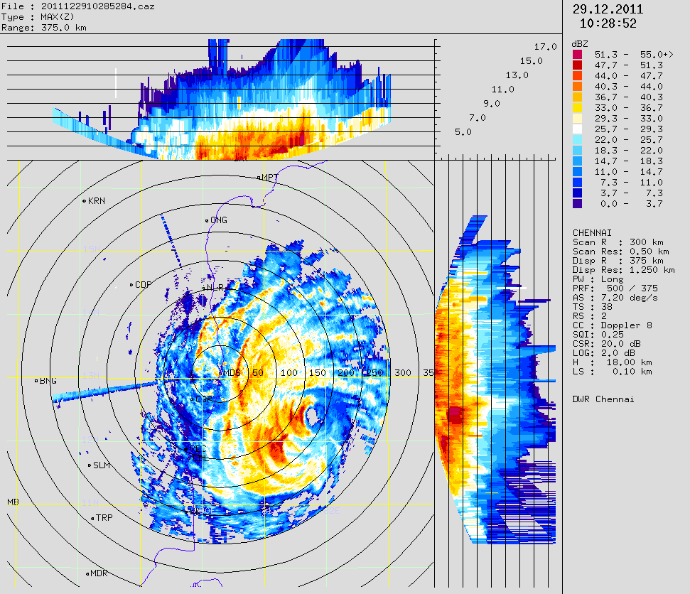
Here's the latest 8:30pm radar image showing the EYE is still visible and located around 120km East of Pondicherry.. http://ow.ly/i/oCdq
Cyclone "Thane" - updates during past 2 hours
Cyclone "Thane" - updates during past 2 hours in http://twitter.com/weatherofindia
--------------------------------------------------------------------------------------------------------------------------
6:53pm, #chennai is having a break is showers ... with wind strength also reduced.. Now heavy rains are approaching Pondicherry coast.
Cyclone Thane is now 6:30pm is at 150km East of Pondicherry... http://ow.ly/i/oBLo >> still having good EYE
Cyclone Thane 6:45pm is weakening, but still a Severe Cyclone... and almost stationary at 12:09:07 N , 81:12:39 E .. 160km S-E of #chennai
RT @kalyansimhan: #chennai #thane http://twitpic.com/806q1h
Cyclone Thane is now 170km S-E of #chennai and East of Pondicherry... now 5:33pm showing signs of weakening!!
RT @trendsmapindia: Indian Weatherman, @weatherofindia is now trending in India http://trendsmap.com/in
@karthimec >> To know more about Cyclone naming ... here's the list and find out what'll be the name of next one .. http://ow.ly/8cU2h
RT @srinisan: @weatherofindia Perfect prediction. We are seeing a heavy downpour here at Sholinganallur, #chennai (5:07pm)
@ketanjatakia >> To know more about Cyclone naming ... here's the list and find out what'll be the name of next one .. http://ow.ly/8cSA1
RT @navysupporter: Navy rescues 11 stranded fishermen off Andhra coast... http://tinyurl.com/bswhl29
RT @scanman: Follow @weatherofindia for regular updates on Cyclone #Thane
Cyclone "Thane" - NO sign of weakening yet! In striking distance 180km East of Pondicherry! .. http://ow.ly/8cSoT
RT @st_hill: @weatherofindia Chennai ppl are advised to stay home after 5/6pm. Extreme heavy rain & winds upto 100kmph will start after 6pm
#chennai - more strong showers approaching city from E-S-E .. will reach in another 30 min
Cyclone "Thane" - NO sign of weakening yet! In striking distance 180km East of Pondicherry!
Position, 3:30pm:: 11:48:01 N and 81:34:20 E
Winds :: up to 125 km/hr
Pressure :: 982mb
Showing NO sign of weakening yet, but expected to weaken from midnight!
Continue to track west towards Pondicherry, now located around 190km East of Pondicherry.
Chennai will have to bear up to 80% of the Cyclones fury !
Extreme heavy rains with Wind gusts up to 100 km/hr will start along Chennai to Pondicherry coast from 6pm.
Latest satellite IR shot, 3pm
--------------------------------------------------------------------------------------

Latest Radar image, 4pm
--------------------------------------------------------------------------------------
One can see the EYE of Cyclone Thane between 150km and 200km

IMD warning, 1:30pm
--------------------------------------------------------------------------------------
JTWC warning, 2:30pm
--------------------------------------------------------------------------------------

Winds :: up to 125 km/hr
Pressure :: 982mb
Showing NO sign of weakening yet, but expected to weaken from midnight!
Continue to track west towards Pondicherry, now located around 190km East of Pondicherry.
Chennai will have to bear up to 80% of the Cyclones fury !
Extreme heavy rains with Wind gusts up to 100 km/hr will start along Chennai to Pondicherry coast from 6pm.
Latest satellite IR shot, 3pm
--------------------------------------------------------------------------------------

Latest Radar image, 4pm
--------------------------------------------------------------------------------------
One can see the EYE of Cyclone Thane between 150km and 200km
IMD warning, 1:30pm
--------------------------------------------------------------------------------------
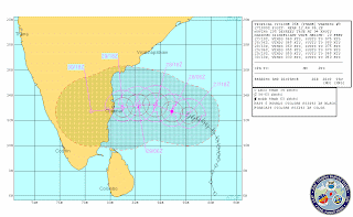
Very Severe Cyclonic Storm 'THANE' over southwest Bay of Bengal:-Cyclone Warning for north Tamilnadu and south Andhra Pradesh coast : Red Message
The very severe cyclonic storm 'THANE' over southwest Bay of Bengal moved westward and lay centered at 1130 hrs IST of today, the 29thDecember 2011 near latitude 12.00N and longitude 82.00E, about 220 km east of Puducherry, 200 km southeast of Chennai (Tamilnadu) and 400 km north-northeast of Trincomalee (Sri Lanka). The system is likely to move westwards and cross north Tamil Nadu coast between Nagapattinam and Chennai, close to Puducherry around early morning of 30th December 2011.
JTWC warning, 2:30pm
--------------------------------------------------------------------------------------

290900Z POSITION NEAR 11.8N 81.7E.
TROPICAL CYCLONE (TC) 06B (THANE), LOCATED APPROXIMATELY 135 NM
SOUTHEAST OF CHENNAI, INDIA, HAS TRACKED WESTWARD AT 06 KNOTS OVER
THE PAST SIX HOURS. ANIMATED MULTISPECTRAL SATELLITE IMAGERY
INDICATES THAT THE SYSTEM HAS INTENSIFIED FURTHER WITH A 15-NM EYE.
A 290245Z SSMIS IMAGE DEPICTS TIGHTLY-CURVED BANDING WRAPPING INTO
THE CENTER WITH THE BULK OF THE DEEP CONVECTION OVER THE WESTERN
SEMI-CIRCLE DUE TO WEAK, EASTERLY VERTICAL WIND SHEAR. THERE IS GOOD
CONFIDENCE IN THE CURRENT POSITION BASED ON THE VISIBLE EYE. THE
CURRENT INTENSITY IS BASED ON DVORAK ESTIMATES RANGING FROM 77 TO 90
KNOTS. TC 06B IS FORECAST TO TRACK WESTWARD, MAKING LANDFALL NEAR
TAU 12, AND IS EXPECTED TO DISSIPATE OVER INDIA BY TAU 36. WITH THE
EXCEPTION OF WBAR, MODEL GUIDANCE IS IN TIGHT AGREEMENT. MAXIMUM
SIGNIFICANT WAVE HEIGHT AT 290600Z IS 22 FEET.
After Cyclone Thane .. showers for N. Tamilnadu coast may last till 2-Jan ... expecting a WET New Year day .. http://ow.ly/i/oAUO
Scattered winter showers possible for E.central India from New Year day to 3-Jan ... http://ow.ly/i/oAUD
Moisture push from Bay into central India along with W.D will provide some heavy rain over E.central India on 1-Jan-12. http://ow.ly/i/oAUu
RT @bubbly_ank: “@aaroo4 Cyclone Thane may wreak havoc - southindia - Chennai - ibnlive http://ping.fm/5LQyf… via @ibnlive”
Cyclone Thane nearing 220km range from chennai and Pondicherry and showing NO sign of weakening ... http://ow.ly/i/oARd
@isaakshi >> 10:20am, Radar image showing the EYE of Cyclone Thane at around 250km S-E of chennai .. http://ow.ly/i/oAzf
Report as on 10 am (IST) Thursday:
"Thane" moves West, draws closer to Chennai, being just 300 kms ESE of the city. (12N and 83E).
Strength maintained at 980 mb, and core surface winds roaring at 130 kmph.
Next update at 12 noon.
Chennai receiving persistant drizzle since last night. Rain intensity to increase from mid day, with thunder. Wind speed likely to touch 40-50 kmph today.
But, the system likely to start weakening from tonite.
chennai - Winds speeds at the height above 500m above sea level are touching a massive 60 to 100 km/Hr .. http://ow.ly/i/oAr1
WoW !! Take a look at the latest Radar image showing the eye of Cyclone Thane ... tracking straight to Pondicherry .. http://ow.ly/i/oApY
chennai - Ground winds from W-N-W reaching upto 25 km/hr is already over City ... http://ow.ly/i/oAld
Presently the outer edge of Cloud mass of Cyclone Thane has touched N. coastal Tamilnadu , chennai ... http://ow.ly/i/oAkQ
Cyclone Thane - Still a category 1 cyclone ... 300 km away from Pondicherry coast .. http://ow.ly/8cH1S
Cyclone "Thane" - Slowly crawling W-S-W ! Now Pondicherry and Cuddalore coast is the target!
Position, 8:30am :: 11:53:59 N and 82:18:00 E
Winds :: reaching upto 120 Km/Hr
Pressure :: 982mb
* Still a category 1 cyclone.
* 300 km away from Pondicherry coast.
* Chennai - will miss the FULL grunt of the system.
* Showers and winds to increase after 1pm ALL along N, central Tamilnadu coast.
Latest Satellite IR shot, 8am
----------------------------------------------------------

JTWC warning and projected path, 8:30am
---------------------------------------------------------------------

IMD warning, 7:30am
------------------------------------------------------------
Winds :: reaching upto 120 Km/Hr
Pressure :: 982mb
* Still a category 1 cyclone.
* 300 km away from Pondicherry coast.
* Chennai - will miss the FULL grunt of the system.
* Showers and winds to increase after 1pm ALL along N, central Tamilnadu coast.
Latest Satellite IR shot, 8am
----------------------------------------------------------

JTWC warning and projected path, 8:30am
---------------------------------------------------------------------

290300Z POSITION NEAR 11.9N 82.3E.
TROPICAL CYCLONE (TC) 06B (THANE), LOCATED APPROXIMATELY 160 NM EAST-
SOUTHEAST OF CHENNAI, INDIA, HAS TRACKED WESTWARD AT 07 KNOTS OVER
THE PAST SIX HOURS. THE CURRENT POSITION IS BASED ON RADAR IMAGERY
FROM CHENNAI, INDIA, A RECENT SATELLITE FIX FROM PGTW, AND A 282221Z
SSMI IMAGE. THE INTENSITY ESTIMATE OF 75 KNOTS IS CONSISTENT WITH
DVORAK T-NUMBER VALUES FROM THREE REPORTING AGENCIES RANGING FROM 65
TO 77 KNOTS. THE DEEPEST CONVECTION REMAINS ALONG THE WESTERN AND
SOUTHERN PERIPHERIES OF WELL-DEFINED LOW LEVEL CIRCULATION CENTER
(LLCC) EVIDENT IN THE 282212Z SSMI IMAGE. RADAR REFLECTIVITY DATA
SHOWS A SYMMETRIC LOW TO MID-LEVEL EYE FEATURE APPROXIMATELY 40 NM
IN DIAMETER. TC 06B CONTINUES TO TRACK WESTWARD UNDER THE STEERING
INFLUENCE OF A SUBTROPICAL RIDGE (STR) POSITIONED TO THE NORTH OF
THE CYCLONE AND SHOULD CONTINUE TRACKING WESTWARD UNTIL MAKING
LANDFALL JUST PRIOR TO TAU 24. THE CYCLONE LIES TO THE WEST OF AN
UPPER-LEVEL ANTICYCLONE. THE UPPER-LEVEL ENVIRONMENT IS MARGINAL,
WITH FAVORABLE BUT DECREASING RADIAL OUTFLOW AND INCREASING VERTICAL
WIND SHEAR. THE CYCLONE IS ALSO MOVING OVER WATERS WITH LOWER HEAT
CONTENT THAT SHOULD, ALONG WITH INCREASING VERTICAL WIND SHEAR AND
DECREASING OUTFLOW, INDUCE SOME WEAKENING PRIOR TO LANDFALL. AFTER
LANDFALL, INTERACTION WITH ROUGH TERRAIN WELL INLAND FROM THE
RELATIVELY FLAT COASTAL AREA WILL LEAD TO STEADY DISSIPATION. ASIDE
FROM THE WEBER BAROTROPIC MODEL, WHICH TRACKS THE CYCLONE POLEWARD
INTO THE STEERING RIDGE, AND THE UK MET OFFICE MODEL, WHICH HOLDS
THE SYSTEM TOO WEAK IN BOTH THE ANALYSIS AND FORECAST AND DEPICTS AN
ERRONEOUS SOUTHWESTWARD TRACK WITH THE LOW-LEVEL FLOW, THE NUMERICAL
MODEL GUIDANCE IS IN GOOD AGREEMENT WITH THE CURRENT FORECAST.
MAXIMUM SIGNIFICANT WAVE HEIGHT AT 290000Z IS 22 FEET.
IMD warning, 7:30am
------------------------------------------------------------
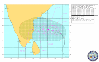
Very Severe Cyclonic Storm THANE over southwest Bay of Bengal:-Cyclone Warning for north Tamilnadu and south Andhra Pradesh coast : Orange Message
The very severe cyclonic storm THANE over southwest Bay of Bengal moved west-southwestward and lay centered at 0530 hrs IST of today, the 29th December 2011 near latitude 12.30N and longitude 83.00E, about 300 km east-southeast of Chennai (Tamilnadu) and 480 km north-northeast of Trincomalee (Sri Lanka). The system is likely to move westwards and cross north Tamil Nadu coast between Nagapattinam and Chennai, close to Puducherry around morning of 30th December 2011. However, as the cyclonic storm will come further close to coast, there is probability of slight weakening before landfall.
Recent Wind Speed of various Cyclones in CHENNAI
Will Very Severe Cyclone Thane beat all the above records so far it has registered 37 km/hr winds without even coming close to the coast.
- Cyclone Jal 47 km/hr (7/11/2010)
- Cyclone Laila 42 km/hr (19/5/2010)
- Cyclone Nisha 42 km/hr (26/11/2008)
- Depression BOB 08 40 km/hr (28/10/2007)
- Depression BOB 07 45 km/hr (27/09/2007)
- Cyclone Ogni 50 km/hr (28/10/2006)
- On 6th, December 1996 (Tropical Cyclone 08B) - a Cyclone which crossed Chennai produced 100 km/hr winds
- On 31st, October 1994 (Severe Cyclonic Storm BOB 03) - a cyclone which crossed Chennai brought 120-140 km/hr winds
For more visit www.tamilnaduweatherman.blogspot.com
Cyclone Thane Update - Cyclone Thane now Very Severe Cyclone with Winds speed over 150 km/hr
The status of Cyclone Thane
-----------------------------------
Date and Time of issue - 011.30 PM (28.12.2011)
IMD Scale - Very Severe Cyclonic Storm
Intensity – 4.4
Pressure – 980 mmb
Wind Speed – 75 kts (140 kmph)
Location – 12.23 N 83.84 E
Weakening - OFF
Rapid Weakening - OFF
Landfall - Around Pondicherry
Crossing Date - 30th December Morning
For more on the tracks and Imagery visit www.tamilnaduweatherman.blogspot.com
Recent Tamil Nadu Cyclones and its awesome radar images
Deep Depression (October 26-29, 2005)


Significant amounts of rainfall recorded in Tamil Nadu are
27-10-2005
Chennai 27, Chennai AP 21, and Red Hills 13 cm
28-10-2005
Tiruvallur and Poondi 27 cm, Red Hills 24 cm, Chembarambakkam 23 cm, Tamaraipakkam 22 cm, Chennai, Cholavaram, Korattur 16 cm, Chennai AP 15 cm and Tambaram 13 cm
-------------------------------------------------------------------------
Cyclone Baaz (November 28- December 02, 2005)


Significant amounts of rainfall recorded in Tamil Nadu are
03-12-2005
Tambaram 31 cm, Chennai AP 28 cm, Thiruvallur and Chennai 23 cm, Arakonam 21 cm, Sriperumbudur 18 cm, Chengalpattu and Red hills 15 cm, Tiruttani 14 cm, Poondi 13 cm, Ponneri 11 cm
----------------------------------------------------------------------------
Cyclone Fanoos (06-10 December , 2005)


Significant amounts of rainfall recorded in Tamil Nadu are
11-12-2005
Ramanathapuram 35 cm, Panruti 14 cm, Senkottai 13 cm, Pamban, Kamudhi and Madhukar 12 cm, Kadaladi 11 cm and Ambasamudram 10 cm
12-12-2005
Ambasamudram 17 cm, Senkottai 13 cm and Paramakudi 12 cm
-----------------------------------------------------------
Depression (27-29 October, 2007)


Significant amounts of rainfall recorded in Tamil Nadu are
29.10.2007
Cyclone Nisha (25-27 November, 2008)


Significant amounts of rainfall recorded in Tamil Nadu are
25.11.2008
Cyclone Laila (17-22 May, 2010)


Significant amounts of rainfall recorded in Tamil Nadu are
20-05-2010
Ponneri 17 cm, Cholavaram 13 cm, Chennai, Anna University and Tamaraipakkam 11 each, Marina DGP Office 10 cm
For more visit - www.tamilnaduweatherman.blogspot.com


Significant amounts of rainfall recorded in Tamil Nadu are
27-10-2005
Chennai 27, Chennai AP 21, and Red Hills 13 cm
28-10-2005
Tiruvallur and Poondi 27 cm, Red Hills 24 cm, Chembarambakkam 23 cm, Tamaraipakkam 22 cm, Chennai, Cholavaram, Korattur 16 cm, Chennai AP 15 cm and Tambaram 13 cm
-------------------------------------------------------------------------
Cyclone Baaz (November 28- December 02, 2005)


Significant amounts of rainfall recorded in Tamil Nadu are
03-12-2005
Tambaram 31 cm, Chennai AP 28 cm, Thiruvallur and Chennai 23 cm, Arakonam 21 cm, Sriperumbudur 18 cm, Chengalpattu and Red hills 15 cm, Tiruttani 14 cm, Poondi 13 cm, Ponneri 11 cm
----------------------------------------------------------------------------
Cyclone Fanoos (06-10 December , 2005)


Significant amounts of rainfall recorded in Tamil Nadu are
11-12-2005
Ramanathapuram 35 cm, Panruti 14 cm, Senkottai 13 cm, Pamban, Kamudhi and Madhukar 12 cm, Kadaladi 11 cm and Ambasamudram 10 cm
12-12-2005
Ambasamudram 17 cm, Senkottai 13 cm and Paramakudi 12 cm
-----------------------------------------------------------
Depression (27-29 October, 2007)


Significant amounts of rainfall recorded in Tamil Nadu are
29.10.2007
Chembarambakkam 18 cm, Red Hills 16 cm, Chennai and Chennai AP 14 cm, Cholavaram and Poondi 10 cm
-----------------------------------------------------------------------Cyclone Nisha (25-27 November, 2008)


Significant amounts of rainfall recorded in Tamil Nadu are
25.11.2008
Thiruvidalmarthu 30 cm, Rameswaram 23 cm, Orathanadu 19 cm, Mayiladuthurai 17 cm, Tirukkattupalli and Pamban 15 cm, Tiruvaiyar and Thanjavur 14 cm, Sirkali and Kollidam 13 cm, Papanasam and Ramanathapuram 12 cm, Kumbakonam and Kattumannarkoil 11 cm, Sethiyathope Anicut and Chidambaram 10 cm.
26.11.2008
Orathanadu and Vedaranniyam 33 cm, Parangipettai and Chidambaram 28 cm Thiruvidalmarthu and Mayiladuthurai 26 cm, Sirkali 25 cm, Kattumannarkoil 24 cm, Cuddalore 22 cm, Sethiyathope Anicut and Kollidam 21 cm, Tiruthuraipndi and Nagapattinam-20 each, -18 each, Karaikal 19 cm, Puduchhery, Adirampattinam Tiruvarur and Kodavasal 18 cm, Nannilam 17 cm, Valangiman, Kumbhakonam, and Tarangambadi 15 cm, Needamangalam and Chembarabakkam 14 cm, Rameswaram, Papansam, Pattukkottai, Mannargudi, Muthupet and Jayamkondam 13 cm, Korattur, Adiramapatnam and Srimushnam 12 cm, Chryyur, Red Hills and Chennai AP 11 cm, Thanjavur, Anna University, Poondi, Cholvaram, Marina and Chennai 10 cm
27.11.2008
Orathanadu 66 cm, Thanjavur 53 cm, Vedaranyam 42 cm, Adiramapattinam 33 cm, Muthupet 30 cm, Kurungulam 28, Kumbakonam 26 cm, Pattukottai 23 cm, Madukkur 21 cm, Tiruvidaimarudur 20 cm, Thiruvaiyaru 19 cm, Papanasam, Tirukkattupalli 18 cm, Chennai AP, Chennai and Chembarabakkam 14 cm, Korattur 12 cm, Nagapattinam, Red Hills, Pondicherry 11 cm, Poondi, Cholavaram, Cuddalore, Tiruchy and Tiruttani 10 cm
28.11.200826.11.2008
Orathanadu and Vedaranniyam 33 cm, Parangipettai and Chidambaram 28 cm Thiruvidalmarthu and Mayiladuthurai 26 cm, Sirkali 25 cm, Kattumannarkoil 24 cm, Cuddalore 22 cm, Sethiyathope Anicut and Kollidam 21 cm, Tiruthuraipndi and Nagapattinam-20 each, -18 each, Karaikal 19 cm, Puduchhery, Adirampattinam Tiruvarur and Kodavasal 18 cm, Nannilam 17 cm, Valangiman, Kumbhakonam, and Tarangambadi 15 cm, Needamangalam and Chembarabakkam 14 cm, Rameswaram, Papansam, Pattukkottai, Mannargudi, Muthupet and Jayamkondam 13 cm, Korattur, Adiramapatnam and Srimushnam 12 cm, Chryyur, Red Hills and Chennai AP 11 cm, Thanjavur, Anna University, Poondi, Cholvaram, Marina and Chennai 10 cm
27.11.2008
Orathanadu 66 cm, Thanjavur 53 cm, Vedaranyam 42 cm, Adiramapattinam 33 cm, Muthupet 30 cm, Kurungulam 28, Kumbakonam 26 cm, Pattukottai 23 cm, Madukkur 21 cm, Tiruvidaimarudur 20 cm, Thiruvaiyaru 19 cm, Papanasam, Tirukkattupalli 18 cm, Chennai AP, Chennai and Chembarabakkam 14 cm, Korattur 12 cm, Nagapattinam, Red Hills, Pondicherry 11 cm, Poondi, Cholavaram, Cuddalore, Tiruchy and Tiruttani 10 cm
Chennai AP 28 cm, Chembarabakkam 24 cm, Anna University 23 cm, Cuddalore 22 cm, Puduchhery 21 cm, Tiruvallur 20 cm, Tamaraipakkam 19 cm, Chengelpet, Ayiyalur, Tanjavur, Vellore-17 each, Pallipattu, Villupuram, Poonamallee, Muthupet, Poondi, Korattur 16 cm, Lalgudi, Chettykulam, Padallur, Red Hills, Tiruchchirapalli 15 cm, Tozhudur, Nungambakkam, perumbalur, Parangipettai, Srimushnam, Tiruvaiyaru, Cholavaram, Ponneri, Vanur, Chennai 14 cm, Tambaram, Tirukkattupalli, Utheriramerur, Kodavasal, Gingee, Kancheepuram-13 each, kollidam, Grand Anicut, Arni, Polur, Tirutani, Vandavasi, Tindivanam, Sriperumbudur-12 each, Thiruvidalmarthu, Chryyar, Samayapuram, Ulundurpet, Marina (DGP Office)-11 each, Tiruchi, Tiruvarur, Valangiman, Vembavur, Kumbhakonam, Orathanadu 10 cm
--------------------------------------------------------------------Cyclone Laila (17-22 May, 2010)


Significant amounts of rainfall recorded in Tamil Nadu are
20-05-2010
Ponneri 17 cm, Cholavaram 13 cm, Chennai, Anna University and Tamaraipakkam 11 each, Marina DGP Office 10 cm
For more visit - www.tamilnaduweatherman.blogspot.com
Wednesday, December 28, 2011
Cyclone "Thane" - Very severe Cyclone now and Chennai may miss the direct hit! ... http://ow.ly/8cbAD
Latest track and projected path suggests that Chennai may miss a direct hit, but Pondicherry is in line of fire! ... http://ow.ly/8cbyK
Cyclone "Thane" - Very severe Cyclone now and Chennai may miss the direct hit!
Position, 8pm :: 12:33:07 N and 84:13:30 E
Winds :: 125 Km/Hr
Pressure :: 981mb
Latest track and projected path suggests that Chennai may miss a direct hit, but Pondicherry is in line of fire!
Very severe cyclone now, and will make landfall with Cyclone strength.
Latest satellite IR shot, 8pm
--------------------------------------------------------------

JTWC warning and projected path, 8:30pm
----------------------------------------------------------------------

IMD warning, 7:30pm
-----------------------------------------------------------
Chennai wind speeds above 0.3km height above sea level has picked up considerably, clocking up to 65 km/Hr. Soon ground winds will also pick-up strength.
Winds :: 125 Km/Hr
Pressure :: 981mb
Latest track and projected path suggests that Chennai may miss a direct hit, but Pondicherry is in line of fire!
Very severe cyclone now, and will make landfall with Cyclone strength.
Latest satellite IR shot, 8pm
--------------------------------------------------------------

JTWC warning and projected path, 8:30pm
----------------------------------------------------------------------

281500Z POSITION NEAR 12.0N 83.7E.
TROPICAL CYCLONE (TC) 06B (THANE), LOCATED APPROXIMATELY 235 NM EAST-
SOUTHEAST OF CHENNAI, INDIA, HAS TRACKED WESTWARD AT 07 KNOTS OVER
THE PAST SIX HOURS. ANIMATED INFRARED SATELLITE IMAGERY DEPICTS
TIGHTLY CURVED BANDING WRAPPING INTO A WELL-DEFINED LOW-LEVEL
CIRCULATION CENTER. A 281208Z SSMIS IMAGE SHOWS AN IMPROVED, THOUGH
ASYMMETRICAL EYEWALL WITH THE BULK OF THE DEEP CONVECTION OVER THE
WESTERN SEMI-CIRCLE. THIS IS DUE TO WEAK, EASTERLY VERTICAL WIND
SHEAR (VWS). OVERALL, THE UPPER-LEVEL ENVIRONMENT HAS IMPROVED WITH
DECREASING VWS AND NEAR-RADIAL OUTFLOW AND, BASED ON THE SSMIS
IMAGE, THE SYSTEM IS NOW VERTICALLY ALIGNED. THERE IS HIGH
CONFIDENCE IN THE CURRENT POSITION BASED ON A SMALL MICROWAVE EYE
FEATURE IN THE SSMIS IMAGE. THE CURRENT INTENSITY HAS BEEN INCREASED
TO 75 KNOTS BASED ON DVORAK ESTIMATES OF 77 KNOTS FROM KNES AND
PGTW. TC 06B IS TRACKING WESTWARD UNDER THE STEERING INFLUENCE OF
THE SUBTROPICAL RIDGE (STR) POSITIONED TO THE NORTH AND IS EXPECTED
TO TRACK WESTWARD UNTIL MAKING LANDFALL NEAR TAU 36. A SHORTWAVE
TROUGH OVER THE NORTHERN BAY OF BENGAL IS FILLING QUICKLY AND
PROPAGATING EASTWARD WITH ZONAL FLOW EXPECTED TO PERSIST, ALLOWING
THE STR TO STRENGTHEN AND MAINTAIN THE WESTWARD STEERING INFLUENCE
THROUGH THE PERIOD. SUBSEQUENTLY MODEL GUIDANCE HAS COME INTO TIGHT
AGREEMENT WITH THE WESTWARD TRACK, ESPECIALLY GFS WHICH HAD
INDICATED A NORTHWESTWARD TRACK AND IS NOW WESTWARD. WBAR REMAINS
THE SOLE OUTLIER WITH AN UNREALISTIC NORTHWESTWARD TRACK BUT HAD
PREVIOUSLY INDICATED A RE-CURVE SCENARIO. THE SYSTEM IS EXPECTED TO
INTENSIFY SLIGHTLY TO A PEAK INTENSITY OF 80 KNOTS BUT COULD
INTENSIFY AS HIGH AS 90 KNOTS IN THE NEXT 24 HOURS. RELIABLE
INTENSITY GUIDANCE PEAKS THE INTENSITY AT 75-80 KNOTS AND MAINTAINS
THIS INTENSITY THROUGH TAU 24. AFTER TAU 24, TC 06B WILL BEGIN TO
WEAKEN AS IT INTERACTS WITH LAND AND SIGNIFICANT WEAKENING WILL
OCCUR THEREAFTER WITH DISSIPATION EXPECTED BY TAU 48 AS THE SYSTEM
TRACKS OVER ROUGH TERRAIN. MAXIMUM SIGNIFICANT WAVE HEIGHT AT
281200Z IS 22 FEET.
IMD warning, 7:30pm
-----------------------------------------------------------
Very Severe Cyclonic Storm 'THANE' over southwest Bay of Bengal:-Cyclone Warning for north Tamilnadu and south Andhra Pradesh coast : Orange Message.
The severe cyclonic storm 'THANE' over southwest Bay of Bengal moved further westward, intensified into a very severe cyclonic storm and lay centered at 1730 hrs IST of today, the 28th December 2011 near latitude 12.50N and longitude 84.50E, about 450 km east-southeast of Chennai (Tamilnadu), 550 km northeast of Trincomalee (Srilanka) and 900 km west-northwest of Port Blair (Andaman & Nicobar Island). The system is likely to move west-westwards, intensify further during next 12 hrs and cross north Tamil Nadu coast between Nagapattinam and Chennai, close to Puducherry around morning of 30th December 2011. However, as the cyclonic storm will come further close to coast after 24 hours, there is probability of slight weakening before landfall.
Chennai wind speeds above 0.3km height above sea level has picked up considerably, clocking up to 65 km/Hr. Soon ground winds will also pick-up strength.

chennai - Along coast, Winds have picked up strength to 50km/Hr from 0.3 Km to 3.3km above sea level... http://ow.ly/i/oxsG
Cyclone "Thane" - Intensified now! and tracking West!
Position, 3pm :: 12:03:00 N , 84:42:09 E
Winds :: 95 Km/hr
Pressure :: 991mb
Now COLA GFS model also agrees to near Chennai landfall on early hrs of 30-Dec as a Cyclone.
Chennai is experiencing Stiff winds from N-N-W for the past 1hr.
IMD expects that "probability of slight weakening before landfall"

Latest satellite IR shot, 3pm
--------------------------------------------------------------

IMD warning, 1:30pm
----------------------------------------------------
JTWC warning and projected path, 2:30pm
--------------------------------------------------------------------------

Winds :: 95 Km/hr
Pressure :: 991mb
Now COLA GFS model also agrees to near Chennai landfall on early hrs of 30-Dec as a Cyclone.
Chennai is experiencing Stiff winds from N-N-W for the past 1hr.
IMD expects that "probability of slight weakening before landfall"

Latest satellite IR shot, 3pm
--------------------------------------------------------------

IMD warning, 1:30pm
----------------------------------------------------
Sub : Cyclonic Storm 'THANE' over southwest and adjoining southeast Bay of Bengal:-Cyclone Warning for north Tamilnadu and south Andhra Pradesh coast : Orange Message
The cyclonic storm 'THANE' over southwest and adjoining southeast Bay of Bengal moved westwards and lay centered at 1130 hrs IST of today, the 28th December 2011 near latitude 12.50N and longitude 85.00E, about 500 km east-southeast of Chennai (Tamilnadu), 600 km northeast of Trincomalee (Srilanka) and 800 km west-northwest of Port Blair (Andaman & Nicobar Island). The system is likely to move west-northwestwards, intensify further during next 24 hrs and cross north Tamil Nadu and south Andhra Pradesh coasts between Cuddalore and Nellore, close to south of Chennai around morning of 30th December 2011. However, as the cyclonic storm will come further close to coast after 24 hours, there is probability of slight weakening before landfall
JTWC warning and projected path, 2:30pm
--------------------------------------------------------------------------

280900Z POSITION NEAR 12.1N 84.5E.
TROPICAL CYCLONE (TC) 06B (THANE), LOCATED APPROXIMATELY 270 NM EAST-
SOUTHEAST OF CHENNAI, INDIA, HAD TRACKED WESTWARD AT 08 KNOTS OVER
THE PAST SIX HOURS. ANIMATED MULTISPECTRAL AND INFRARED SATELLITE
IMAGERY INDICATES THAT THE LOW-LEVEL CIRCULATION CENTER (LLCC) HAS
CONTINUED TO CONSOLIDATE OVER THE PAST 06 HOURS DESPITE PERSISTENT
MODERATE (10-20 KNOTS), EASTERLY VERTICAL WIND SHEAR (VWS). THIS
IMPROVEMENT IS LIKELY DUE TO THE GOOD OVERALL OUTFLOW. A 280256Z
SSMIS IMAGE DEPICTS IMPROVED ORGANIZATION WITH A MICROWAVE EYE
FEATURE AND SYMMETRIC EYEWALL, ALTHOUGH SOMEWHAT FRAGMENTED. THE
SSMIS IMAGE, HOWEVER, INDICATES THAT THE SYSTEM IS TILTED SLIGHTLY
SOUTHWESTWARD. THE CURRENT POSITION IS BASED ON EXTRAPOLATION FROM
THE SSMIS 37 GHZ IMAGE. THE CURRENT INTENSITY IS BASED ON DVORAK
ESTIMATES OF 65 KNOTS FROM KNES AND PGTW. TC 06B IS TRACKING
WESTWARD UNDER THE STEERING INFLUENCE OF THE SUBTROPICAL RIDGE (STR)
POSITIONED TO THE NORTH AND IS EXPECTED TO TRACK WESTWARD UNTIL
MAKING LANDFALL NEAR TAU 36. A SHORTWAVE TROUGH OVER THE NORTHERN
BAY OF BENGAL IS FILLING AND PROPAGATING EASTWARD WITH ZONAL FLOW
EXPECTED TO PERSIST, ALLOWING THE STR TO STRENGTHEN AND MAINTAIN THE
WESTWARD STEERING INFLUENCE THROUGH THE PERIOD. SUBSEQUENTLY MODEL
GUIDANCE HAS COME INTO TIGHT AGREEMENT WITH THE WESTWARD TRACK,
ESPECIALLY GFS WHICH HAD INDICATED A NORTHWESTWARD TRACK AND IS NOW
WESTWARD. WBAR REMAINS THE SOLE OUTLIER WITH AN UNREALISTIC
NORTHWESTWARD TRACK BUT HAD PREVIOUSLY INDICATED A RE-CURVE
SCENARIO. THE SYSTEM IS EXPECTED TO INTENSIFY SLIGHTLY TO A PEAK
INTENSITY OF 70 KNOTS WITH MODERATE VWS OFFSET BY THE GOOD OUTFLOW.
MAXIMUM SIGNIFICANT WAVE HEIGHT AT 280600Z IS 21 FEET.
Report of 12.30 pm (IST) Wednesday.
As the ridge deepens, "Thane" moves due west. Moved marginally west in last 6 hrs, and is 550 kms due west of Chennai. Convection increases in the SW quadrant. Clouds at phenomenal height, with top at -85c ! Pressure at 992, but winds raging at 100 kmph. Seas getting rough.
Could strike by Friday, slightly North of Chennai, possibly at current strength.
Cyclone "Thane" - Slowly Moving W-N-W and intensifying !! chennai may get a direct hit on early hrs of 30-Dec .. http://ow.ly/8bGHq
Cyclone "Thane" - Slowly Moving W-N-W and intensifying !!
Position, 7:30am :: 12:36:21 N , 85:21:06 E
Pressure :: 991mb
Winds :: 95 Km/Hr
Chennai may get a direct hit on early hrs of 30-Dec, but the system may be a Deep Depression at the time of landfall !! Next 24hrs will decide the strength.
Latest satellite IR shot,
-----------------------------------------------------------

IMD warning, 7:30am
-----------------------------------------------------------
JTWC warning and projected path, 2:30am
--------------------------------------------------------------
272100Z POSITION NEAR 12.5N 85.9E.
Pressure :: 991mb
Winds :: 95 Km/Hr
Chennai may get a direct hit on early hrs of 30-Dec, but the system may be a Deep Depression at the time of landfall !! Next 24hrs will decide the strength.
Latest satellite IR shot,
-----------------------------------------------------------

IMD warning, 7:30am
-----------------------------------------------------------
Cyclonic Storm "THANE" over southwest and adjoining southeast Bay of Bengal:-Cyclone alert for north Tamilnadu and south Andhra Pradesh coast : Yellow Message
The cyclonic storm "THANE" over southwest and adjoining southeast Bay of Bengal remained practically stationary and lay centered at 0530 hrs IST of today, the 28th December 2011 near latitude 12.50N and longitude 86.00E, about 600 km east-southeast of Chennai (Tamilnadu), 650 km northeast of Trincomalee (Srilanka) and 700 km west-northwest of Port Blair (Andaman & Nicobar Island). The system is likely to move west-northwestwards slowly, intensify into a severe cyclonic storm during next 24 hrs and cross north Tamil Nadu and south Andhra Pradesh coasts between Cuddalore and Nellore around morning of 30th December 2011.
--------------------------------------------------------------
272100Z POSITION NEAR 12.5N 85.9E.
TROPICAL CYCLONE (TC) 06B (THANE), LOCATED APPROXIMATELY 350 NM EAST
OF CHENNAI, INDIA, HAS TRACKED WEST-NORTHWESTWARD AT 04 KNOTS OVER
THE PAST SIX HOURS. ANIMATED INFRARED SATELLITE IMAGERY SHOWS
CONVECTION DEEPENING AND CONSOLIDATING AROUND A BROAD LOW-LEVEL
CIRCULATION CENTER (LLCC). A 271419Z 37 GHZ SSMIS IMAGE REVEALS A
CONCENTRIC AND WELL-ORGANIZED LLCC, WITH THE MAJORITY OF DEEP
CONVECTION OCCURRING OVER THE SOUTHWESTERN QUADRANT. TOTAL
PRECIPITABLE WATER LOOPS INDICATE THE DEEP MOISTURE ASSOCIATED WITH
THE SYSTEM IS SEPARATING FROM VIGOROUS WESTERLIES ON THE EQUATORIAL
SIDE, WHICH MAY LIMIT FURTHER INTENSIFICATION. ANIMATED WATER VAPOR
IMAGERY REVEALS THAT THE WEAKENING EFFECTS OF SHEAR ARE BEING
COMPENSATED BY VIGOROUS POLEWARD OUTFLOW. THE CURRENT INTENSITY IS
BASED ON A COMBINATION OF A DVORAK ASSESSMENT OF 55 KNOTS FROM PGTW
AND THE MICROWAVE SIGNATURE. TC 06B IS UNDERNEATH THE SUBTROPICAL
RIDGE IN A REGION OF HIGHLY DIFFLUENT FLOW, WITH VERTICAL WIND SHEAR
ESTIMATED AT 15 KNOTS. ALONG-TRACK SEA SURFACE TEMPERATURES ARE 26
TO 27 DEGREES. A MID- TO UPPER-LEVEL STEERING RIDGE ANCHORED OVER
MYANMAR IS DRIVING TC 06B WESTWARD. THERE IS A MILD WEAKNESS IN THE
RIDGE OVER THE INDIAN SUBCONTINENT, AND GFS IS SHOWING AN
EXAGGERATED POLEWARD MOVEMENT IN RESPONSE TO THAT WEAKNESS. OTHER
GUIDANCE IS CONSISTENT IN STEERING THE STORM WESTWARD TO MAKE
LANDFALL NEAR CHENNAI, WITH INCREASING SHEAR ALONG TRACK BRINGING
ABOUT A WEAKEING TREND PRIOR TO LANDFALL. THE TRACK FORECAST STAYS
SOUTH OF CONSENSUS IN ORDER TO COMPENSATE FOR THE POLEWARD TRACKS OF
GFS AND WBAR. MAXIMUM SIGNIFICANT WAVE HEIGHT AT 271800Z IS 20 FEET.

Recall of 1994 Severe cyclone - As Chennai fears from a Severe Cyclone Thane
Anyone has memory of 1994 Severe Cyclone that crossed Chennai) – It was the destructive cyclone to hit Chennai in last 20 years or even more.
This cyclone i witnessed it first hand…..to me this created havoc in Chennai. 24 cm rainfall in 24hrs coupled with 120 km/hr winds…. The cyclone scared the shit out of me. I watched the high winds with power cut without sleep. Still its scary. Hope Cyclone Thane doesnot make any destruction like this.
http://tamilnaduweatherman.blogspot.com/2011/12/recall-of-1994-cyclone-as-chennai-fears.html
Tuesday, December 27, 2011
AWEFUL THANE :: Prevention and Mitigation
Even during this time it seems AWFUL. It will become a powerful storm and cause havoc for Chennai. Precautionary measures need to be initiated now itself. Some time it may become CAT 2 storm. Government must gear up all necessary precautions before landfall to avoid live and property loss. Whether it will fizzle out or strike precaution measures are safety measures.
I pray Tamilnadu Government officials and general public to be prepared to face the storm.
hazards can be reduced by planned mitigation and preparedness measures.
I pray Tamilnadu Government officials and general public to be prepared to face the storm.
- Store food and water.
- Tighten all loose bound structures in your house.
- Don't touch wet electrical appliances and keep away from electrical circuits.
- Stay out of the building if flood water enters the building and
- Be prepared to be evacuated to higher {KNOWN] places.
- Avoid walking or driving through flood waters.
- Bring valuable things in a secure place well after the first caution notice.
- Keep battery powered lights for use during nights.
- Monitor weather warnings / weather alerts for better preparedness .
hazards can be reduced by planned mitigation and preparedness measures.
Cyclone "Thane" - Moving W-N-W, and will intensify to Severe Cyclone in 12hrs ... http://ow.ly/8bfhf
Cyclone "Thane" - Moving W-N-W, and will intensify to Severe Cyclone in 12hrs
Position, 9pm :: Lat : 12:19:01 N Lon : 86:15:13 E
Winds :: 90 Km/Hr
Pressure :: 993mb
Tonight it'll intensify further to Severe Cyclone and continue to crawl W-N-W or West
Latest satellite IR shot, 9pm
---------------------------------------------------------

JTWC warning and projected path, 8:30pm
---------------------------------------------------------------------------------
IMD warning, 7pm
---------------------------------------------------------
Winds :: 90 Km/Hr
Pressure :: 993mb
Tonight it'll intensify further to Severe Cyclone and continue to crawl W-N-W or West
Latest satellite IR shot, 9pm
---------------------------------------------------------

JTWC warning and projected path, 8:30pm
---------------------------------------------------------------------------------
271500Z POSITION NEAR 12.3N 86.3E.
TROPICAL CYCLONE (TC) 06B (THANE), LOCATED APPROXIMATELY 375 NM EAST
OF CHENNAI, INDIA, HAS TRACKED WEST-NORTHWESTWARD AT 04 KNOTS OVER
THE PAST SIX HOURS. ANIMATED MULTISPECTRAL SATELLITE IMAGERY
CONTINUES TO INDICATE A CONSOLIDATING LOW-LEVEL CIRCULATION CENTER
(LLCC) WITH IMPROVED DEEP CONVECTIVE BANDING WRAPPING INTO THE
CENTER; HOWEVER, BASED ON A 271221Z SSMIS IMAGE, THE LLCC IS BROAD
AND REMAINS ON THE EASTERN EDGE OF THE DEEP CONVECTION DUE TO LIGHT
TO MODERATE, EAST-SOUTHEASTERLY VERTICAL WIND SHEAR. DESPITE
THE IMPROVED ORGANIZATION, THERE IS FAIR CONFIDENCE IN THE CURRENT
POSITION DUE TO THE BROAD NATURE OF THE LLCC AS DEPICTED IN A
270327Z ASCAT IMAGE. THE CURRENT INTENSITY IS ASSESSED SLIGHTLY
HIGHER THAN THE DVORAK ESTIMATES OF 55 KNOTS FROM PGTW AND KNES.
TC 06B IS FORECAST TO TRACK WESTWARD UNDER THE STEERING INFLUENCE OF
A DEEP SUBTROPICAL STEERING RIDGE EXPECTED TO BUILD TO THE NORTH
WITHIN THE NEXT 24-36 HOURS. THE BULK OF THE DYNAMIC MODEL GUIDANCE
IS IN GOOD AGREEMENT WITH THE WESTWARD TRACK. GFS HAS TRENDED TO A
MORE WEST-NORTHWESTWARD TRACK OVER THE PAST FEW RUNS AND IS ON THE
NORTHERN EDGE OF THE AIDS ENVELOPE. WBAR REMAINS THE SOLE OUTLIER
WITH AN UNREALISTIC RAPID RE-CURVE TRACK INTO BANGLADESH. THE JTWC
FORECAST FAVORS THE ECMWF, GFDN, UKMO AND NOGAPS SOLUTIONS AND IS
POSITIONED SOUTH OF THE MODEL CONSENSUS TO OFFSET WBAR. TC O6B IS
EXPECTED TO INTENSIFY SLIGHTLY OVER THE NEXT 24 HOURS DUE TO GOOD
OVERALL POLEWARD OUTFLOW, BUT SHOULD WEAKEN AS IT APPROACHES THE
INDIAN COAST. NEAR TAU 72, THE SYSTEM WILL DISSIPATE RAPIDLY DUE TO
LAND INTERACTION. MAXIMUM SIGNIFICANT WAVE HEIGHT AT 271200Z IS 17
FEET.

IMD warning, 7pm
---------------------------------------------------------
Cyclonic Storm THANE over southeast and adjoining southwest Bay of Bengal:-Cyclone alert for north Tamilnadu and south Andhra Pradesh coast : Yellow Message
The cyclonic storm THANE over southeast Bay of Bengal moved northwestwards and lay centered at 1730 hrs IST of today, the 27th December 2011 near latitude 12.50N and longitude 86.50E, about 650 km east-southeast of Chennai (Tamilnadu), 700 km northeast of Trincomalee (Srilanka) and 670 km west-northwest of Port Blair (Andaman & Nicobar island). The system is likely to move west-northwestwards, intensify into a severe cyclonic storm during next 24 hrs and cross north Tamil Nadu and south Andhra Pradesh coast between Cuddalore and Nellore by morning of 30th December 2011.
RSMC TROPICAL CYCLONES, NEW DELHI - Remarks
--------------------------------------------------------------------------------------
CONSIDERING THE ENVIRONMENTAL FEATURES, THE SEA SURFACE TEMPERATURE IS ABOUT 27-28 DEG. C. OVER THE REGION. IT IS RELATIVELY LESS TOWARDS TAMIL NADU AND SRI LANKA COAST BECOMING 26-27 DEG. C. THE OCEAN THERMAL ENERGY IS 50 - 80 KJ/CM SQUARE AROUND THE SYSTEM CENTRE. IT IS 50-80 KJ/CM SQUARE TO THE WEST AND WEST-NORTHWEST OF SYSTEM AND LESS THAN 50 KJ/CM SQUARE NEAR TAMILNADU AND NORTH SRILANKA COAST. THE MADDEN JULIAN OSCILLATION INDEX CURRENTLY LIES OVER PHASE 5. AS PER STATISTICAL AND NWP MODEL PREDICTIONS, IT IS EXPECTED TO LIE IN PHASE 5 DURING NEXT FIVE DAYS. THE PHASE 5 IS FAVOURABLE FOR INTENSIFICATION, AS PER OUR PAST STUDIES. THE UPPER TROPOSPHERIC RIDGE LIES ALONG 15 DEG. N AND HENCE HELPS IN WEST-NORTHWESTWARD MOVEMENT OF THE SYSTEM. THE LOW LEVEL CONVERGENCE AS WELL AS UPPER LEVEL DIVERGENCE DOES NOT SHOW ANY CHANGE DURING PAST SIX HOURS. THE VERTICAL WIND SHEAR BETWEEN 200 AND 850 HPA LEVELS IS LOW TO MODERATE (10-15 KNOTS) AROUND SYSTEM CENTRE. THERE IS NO SIGNIFICANT CHANGE IN WIND SHEAR DURING PAST 24 HRS. CONSIDERING THE NWP MODEL GUIDANCE, MOST OF THE MODELS SUGGEST THE INTENSIFICATION OF THE SYSTEM INTO A SEVERE CYCLONIC STORM BY NEXT 24 HRS. HOWEVER THEY SUGGEST SLIGHT WEAKENING BEFORE LANDFALL. WITH RESPECT TO TRACK, MOST OF THE MODELS SUGGEST WEST-NORTHWESTWARD AND THEN WESTWARD MOVEMENT. A FEW MODELS SUGGEST NORTH-NORTHWESTWARD/ NORTHWESTWARD MOVEMENT. THE CURRENT FORECAST IS IN AGREEMENT WITH THE NWP MODELS OF FIRST CATEGORY AND SYNOPTIC GUIDANCE.
Subscribe to:
Posts (Atom)