Monsoon Watch-7
El-Nino Factor Over:
With all the major indicators now below El Niño thresholds,latest observations show that sea surface temperatures, trade winds, the Southern Oscillation Index and cloudiness over the Pacific have all returned to levels considered typical of neutral.
The tropical Pacific has continued to cool during May,with NINO indices all at neutral levels. The weekly SST anomaly map shows warm anomalies covering most of the equatorial Pacific.
Thus the El-Nino is over and done with!This parameter need not be mentioned vis-a-vis the progress of the Monsoon now, and its impact, finished now, will not be discussed in our MW. Even the June short-rainfall danger, due to the El-Nino, seems to be over now.
MJO Indications:
Acoording to the Australian Bureau of Met. -"The active MJO is currently located near longitude 110 East, entering the Maritime Continent region.
The latest guidance suggests that the MJO event will slow as it moves into the Maritime Continent region, and begin to weaken in intensity over the coming week or two".
The majority of dynamical model MJO index forecasts indicate a weakening MJO signal during Week-2. Now translated, I presume it means less rain for the West Coast of India after May end.So,it means, the active MJO in the Arabian Sea will bring in the Monsoon by May end, to the South-Western Coast of India, and then the Eastward movement of the MJO will weaken the rains in the first week of June ?? I am not well versed with the MJO actions and resulting effects, so would not like to comment or forecast on this parameter.
The Heat Wave in Central India is intense,(IMD day temp.Maps), and with a high of 47.3c at Wardha, we have a whole lot of 45s, 46s in the Sub-Continent.The highest of 48c onThursday, 13th. May,in the region was at Nawabshah (Pakistan).This augers well for the forming of the seasonal low, now at 998 mb.
Thursday, May 13, 2010
Readings as on 13th.May:
Readings as on 13th.May:
Highest In Asia : Nawabshah (Pakistan): 48c.
Highest in India: Chandrapur (Maharashtra):47.3c
Minimum Temperatures over 30c:
Chandrapur: 32.2c, Kurnool 31.9c, Kota:31.8c,Brahmapuri:31.1c, Gondia:30.4c, Jodhpur:30.3c.
Day's Maximum today in Mumbai:Colaba:35.5c, S'Cruz:33.7c.
Highest In Asia : Nawabshah (Pakistan): 48c.
Highest in India: Chandrapur (Maharashtra):47.3c
Minimum Temperatures over 30c:
Chandrapur: 32.2c, Kurnool 31.9c, Kota:31.8c,Brahmapuri:31.1c, Gondia:30.4c, Jodhpur:30.3c.
Day's Maximum today in Mumbai:Colaba:35.5c, S'Cruz:33.7c.
RT @Vinoth27: See the Beauty of Kerala Backwaters - http://ht.ly/1Kzf4 kerala backwaters photography photo india beauty landscape
Category:
backwaters,
beauty,
India,
Kerala,
landscape,
photo,
photography
6pm, Showers over Nilgiris, coastal Orissa, Assam, N. Andhra, a new cell over S.central Kerala.. http://ow.ly/i/1wXQ
Weather Chart

Courtesy : Thai meteorological Department
The HIGH pressure seen in [NORTH] Indian Ocean and extending in ARABIAN sea is NOT allowing monsoonal winds advancing into Northern Hemi sphere. This is the general pressure pattern in April and mid May.
Indian Weatherman
Indian 
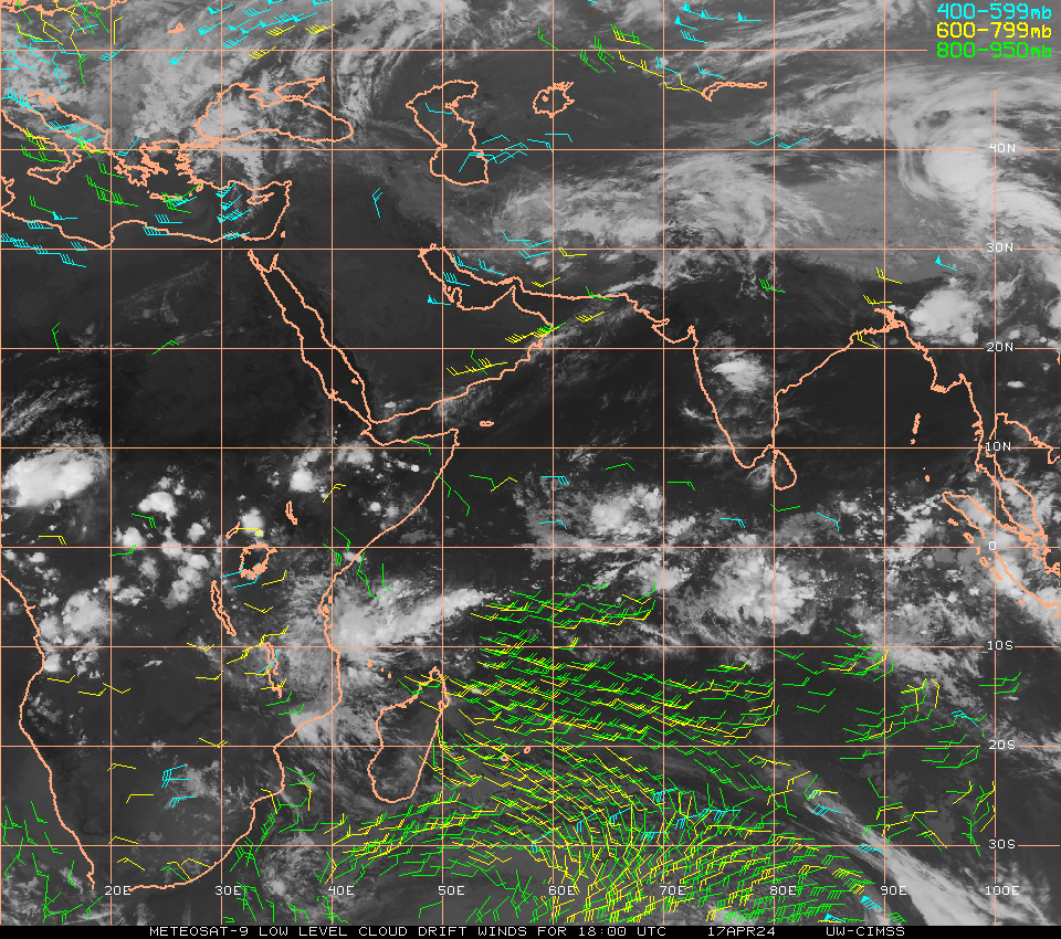
Low level cloud drift winds : 13.5.2010/0900 UTC
The above is the Metosat wind analysis. 950-800 hPa winds in southern hemisphere are concentrating and converging near East African coast of Tanzania . This concentration has not crossed equator. This is low level wind. The anti cyclonic circulation in southern hemisphere is lying between 20 DEG South to 35 DEG South and between 75 deg EAST to 110 deg EAST. It may take another ten days to concentrate and to become SEM winds.
4pm, Showers over central Andhra, central Orissa, W. Bengal and thunder cells popping out over N-W corner Tamilnadu.. http://ow.ly/i/1wSL
Rainfall data from 1-Jan-2010 to 13-May-2010.. updated
India toppers from 1.1.10 to 13.5.2010
———————————–
Cherrapunji 412 cm
Passighat 125 cm
Silchar 111 cm
Dibrugarh 94 cm
Itanagar 89 cm
Gangtok 82 cm
North Lakhimpur 69 cm
Dhubri 60 cm
Cherrapunji crossed 4000mm mark before monsoon with a 209mm rainfall yesterday. It has received 2733% above normal rainfall from march 1st. Will it able to cross 6000mm before the onset of monsoon
posted by Pradeep
Nagercoil - Various parts of the district witnessed widespread rain on 12-May-10 .. http://ow.ly/1Ktss
12pm, Most of India is clear and HOT. Tamilnadu & Kerala having partial cloud cover,And Kashmir getting some showers.. http://ow.ly/i/1wM9
Eruption of Eyjafjallajökull Volcano, Iceland
Iceland’s Eyjafjallajökull Volcano continues to erupt a thick plume of ash. On May 11, 2010, the ash was streaming almost directly south, visibly extending at least 860 kilometers (530 miles) from Eyjafjallajökull. According to the London Volcanic Ash Advisory Center, the ash reached altitudes of 14,000 to 17,000 feet (4,300 to 5,200 meters). CNN reported that some Spanish and Moroccan airports were closed at the time. On May 10th, the Icelandic Met Office reported continuous ash fall south of the volcano, with as depths reaching 2-3 millimeters (roughly 0.1 inches).
This natural-color image was acquired by the Moderate Resolution Imaging Spectroradiometer aboard NASA’s Terra satellite at 12:15 p.m. local time.
Readings of 12th. May:
Readings of 12th. May:
Highest in Asia: Nawabshah (Pakistan): 49c, Chorr (Pakistan) 47c.
In India, the highest maximum temperature of 46.9°C has been recorded at Chandrapur (Maharashtra) and Bramhapuri (Maharashtra). Mahableshwar:32.5c
Mumbai Today: Colaba:35.6c, S'Cruz:33.9c. Thane (AWS):35.6c
Minimums over 30c:
Kota: 32.4c, Jodhpur: 31.6c, Kurnool 31.5c and Ramagundam:31c.
Subscribe to:
Comments (Atom)


