You can enjoy the cool weather.
Travel in the Nilgiris Railway. A blue colour train with wooden coaches with stream engine and cream with wooden coaches, large windows and Aweseome journey.
Go for long walks in the chilled weather.
Visit country side and feel the real ooty weather, culture.
Dont forget to visit golf at the Gymkhana Golf course. (Only members are allowed).
Visit the Testates and Factories. There are plenty of Tea estates around the Ooty Rural & urban areas.
Visit the Mudumalai forest sanctuary. (It takes around 2 hours from Ooty)
Visit Defense Services Staff College.
Visit 6th mile and also the 9th mile (Movie shooting spots. Very calm & green area. Very peaceful area.
You can get form Fresh Carrot on the way.
************
The natural scenic beauty of Ooty or Udhagamandalam as it is called now is something that has to be seen to be believed. Situated on the Nilgiri mountain ranges as part of the Western Ghats, this hill station was developed by the British rules as their summer retreat. Ooty is called as the queen of hill stations and the place truly justifies the title. Nestled in a deep valley on the Tamilnadu side of the Western Ghats, Ooty is visited by millions of tourists every year. It is situated at a height of 1350 meters above sea level and borders the state of Kerala on the western side.
There are many wonderful tourist spots in and around Ooty and a single day is not enough to visit every one of them. There are many parks in Ooty; some famous ones are Government Botanical Garden, Centenary Rose Garden and children’s park. Talking about gardens, Ooty is the venue of the famous flower show every year in which thousands of beautiful and unique flowers are kept on display and for sale. This flower show is a truly spectacular show indeed. Right in the center of Ooty is a big lake on which you can enjoy a boat ride. Ooty is also very close to Doddabetta Peak, which is the highest point of the Western Ghats at around 2300 meters. A visit to Ooty cannot be fulfilled without a ride on the toy train. The train starts from Mettupalayam and winds its way around the Nilgiri Mountain towards Ooty and the sights on the way as it approaches Ooty will take your breath away.
Ooty is well connected by roads and the nearest regular railway station is Mettupalayam and the closest airport is Coimbatore. There is plenty of accommodation available, right from cheap budget hotels to luxurious five star hotels. The best time to visit Ooty is From March to July when the temperatures will hover between 15 degrees centigrade to 30 degrees centigrade. The winter months of September to January are very cold with temperatures sometimes nearing freezing point. One visit to Ooty is compulsory in any nature lover’s iternary.

Wednesday, December 31, 2008
Low temperatures thru India
Chennai:
Recorded another low temperature night.
19.4°C (6:39am)
Latest satellite image shows some activity over the South-east bay region.
And some GFS suggests, we might have some showers after 7-Jan-09 and before 20-Jan-09.
But at present we can enjoy this DRY and LOW temperatures for next 3 days.
India:
All over india is experiencing a COLD wave.
Here are the recorded LOW temperatures.
New Delhi: 8.2°C
Mumbai: 12.8°C
Kolkata: 14.4°C
Ahmedabad: 13.0°C
Bangalore: 14.0°C
Bhopal: 12.4°C
Bhubaneswar: 16.0°C
Dehradun: 6.4°C
Goa: 18.4°C
Guwahati: 11.8°C
Hyderabad: 13.9°C
Lucknow: 8.5°C
Nagpur: 11.9°C
Patna: 9.4°C
Pune: 8.6°C
Srinagar: -1.8°C
Trivandrum: 19.8°C
Shimla: 5.7°C
Ranchi: 7.7°C
Tuesday, December 30, 2008
Cyclone "Billy"
A classic Cyclone photo of cyclone "Billy", here u can see it's leaving Australia. Taken on 25-Dec-08.


Sunday, December 28, 2008
Live webcam shot from Antarctica
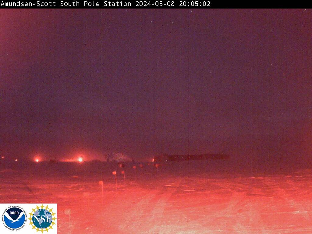
This photo is of the Amundsen-Scott South Pole Station taken every 15 minutes (if a relay satellite is available for transmission) from the roof of the National Science Foundation's Atmospheric Research Observatory which houses NOAA/ESRL's Clean Air Facility. In order to preserve the life of the camera, it is tilted down onto the snow when the sun is in the field of view, which occurs for several weeks around sunset (March) and sunrise (September) when the sun marches in a circle above the horizon. From mid-April until mid-August the moon and the aurora australis provide the only natural lighting. The new station can be seen to the right in the photo; the old (circa 1973) domed station is to the left. The new station is elevated above the snow to prevent it being buried by the drifting snow (the present fate of the old domed station).
 alt="Click for Maitri, Antarctica Forecast" height=50 width=150>
Maitri's 'first words' from Antarctica
Taken from MSN
A member of the 27th Indian Scientific Antarctica Expedition, 56-year-old Sudhir Khandelwal, has typed, so far, 39 posts and nearly 15,000 words, with another one and a half months of his stay to go.
A consultant psychiatrist at the All India Institute of Medical Sciences (AIIMS), Khandelwal records fascinating vignettes of daily life at himalayanadventurer.blogspot.com. He writes about the effects of static electricity that result in 'powerful' handshakes, eccentric food habits, hikes on the ice shelf and the saga of a Skua bird family nesting near the station.
Khandelwal is in Antarctica for four summer months to conduct a study of short and long-term effects of extreme isolation and climatic conditions on the general and mental health on expedition members.
India's second research base in Antarctica, Maitri, is located on the rocky mountain area in the eastern part of the continent called Schirmacher Oasis, where the average annual temperature is minus 10 degrees Celsius.
Naturally, maintaining a blog is not an easy task from Maitri station, which has no direct access to the Internet. Electronic communication is limited to a single shared e-mail address, with the mails uploaded and downloaded once a day by connecting to the Amos server in the Netherlands.
So, almost every other day, Khandewal writes and mails his musings to his elder son, a computer professional in San Francisco who uploads and maintains the website.
"It's been a hobby to write my interesting experiences and travelogues to share with family and friends over email. When I was discussing with my son, Kushagra, how to reach the mailing list for sharing my experiences, he suggested the idea of starting a blog," Khandelwal told in an email interview.
With telephone calls being rather expensive, his family in India and the US find the blog the best way to ensure his well-being.
"I am usually looking at the clock when I am on the phone. His blog helps me visualise his stay in those conditions and keeps me assured of his welfare," said his wife Chitra Khandelwal, who lives in New Delhi.
Khandelwal's travel from India to Antarctica took about three days and four flights - from Goa to Mumbai, Mumbai to Johannesburg, then to Cape Town, and finally the last leg on a chartered Il-76 aircraft to a landing on the ice field at Novo air base, nine kilometres from Maitri on Nov 15, 2007.
"It looked like a huge white ocean with a tinge of blue here and there, then it looked like a white sand desert with patches of mirage appearing here and there," Khandelwal said.
As part of the summer team, Khandelwal lives in a pre-fabricated cabin with four bunker beds outside the main building. It is a rather comfortable stay with round-the-clock open pantry, a recreation room and a gymnasium.
Not surprisingly, one of the important members of the team is the station cook, Ram Das from the Indo-Tibetan Border Police (ITBP).
"Everybody tries to keep him in good humour because their health and mood depend on him," Khandewal writes, tongue-in-cheek.
From fresh fruits and vegetables at the start of the residency period, the menu moves on to food items that are frozen, tinned or powdered.
"Current fads among many of the 26th (expedition) team members are Maggie noodles and eggs. They are now sick of eating frozen vegetables and daal (lentils) for the last many months," he said.
Therefore, when visitors from the neighbouring Novolazarevskaja Russian station came to Maitri for Christmas, they brought a much-appreciated gift - fresh vegetables.
The evening hours in Maitri are often the period to hone latent talent, with the station now boasting an in-house chorus, a trio of enthusiastic party dancers, Urdu poetry aficionados, wood artists, aspiring chefs and even an amateur hair stylist. The night usually wraps up with a movie from the well-stocked DVD library.
The avenues for entertainment, however, will become wide open once the under-construction Earth Station becomes functional in March, allowing 24-hour Internet access and even beaming Indian TV channels.
"I am persuading two members who will be wintering here (spending nearly 15 months) to also start writing a blog once they start enjoying full internet connectivity and web browsing," Khandelwal told IANS.
Meanwhile, with summer nights in Antarctica always aglow with dull sunlight, a full moon night evokes a nostalgic post.
"But the full moon won't shine as it would in Delhi. It will be there in the sky but with no moonlight at all. The bright full moon from the confines of the home makes all the troubles of living in Delhi worthwhile," he said.
India in Antartica
Maitri,Antarctica

Here's the weather report & forecast for Maitri Antartica base.
Weather During Past 24 Hours:
Partly cloudy sky
Present:
Average MSL Pressure(hPa): 1002.4
Average Air Temperature(°c): -02.0
Average Wind Speed (Kt): 04
Maximum Temperature(°c): +00.4
Minimum Temperature(°c): -02.9
Maximum Wind Speed (Kt): 10
24-hour Precipitation (mm): 0
Weather summary : Generally cloudy sky becoming overcast towards evening with light to moderate surface winds.
Forecast for next 24 Hour : Generally cloudy sky light to moderate surface winds. Possibility of light snow.
Saturday, December 27, 2008
Another dull and dry day.
Just another Dry & Dull day passing by.
Humidity below 50%.
Max day temperature around 29 degrees.
Mild cold winds around.
And
Night is going to be long and dry, and morning will be cold.
Humidity below 50%.
Max day temperature around 29 degrees.
Mild cold winds around.
And
Night is going to be long and dry, and morning will be cold.
Thursday, December 25, 2008
Mild Christmas morning
Happy Christmas!! to all our readers and supporters!
Slightly cold morning 23.1°C (6:30am) with heavy DEW around.
Today we'll have a slightly high humidity.
After yesterday morning's MILD shower and drizzles there was nothing there in Afternoon.
Here is a CLEAR looking VISIBLE satellite shot of INDIA this morning.

Slightly cold morning 23.1°C (6:30am) with heavy DEW around.
Today we'll have a slightly high humidity.
After yesterday morning's MILD shower and drizzles there was nothing there in Afternoon.
Here is a CLEAR looking VISIBLE satellite shot of INDIA this morning.

Wednesday, December 24, 2008
Drizzle morning..!!
Chennai:
After a mild night and morning.
We had a Drizzle at around 8:30 AM.
And more LOW cloud formations can be seen from North-east.
There's no GFS forecast for this. And even the latest satellite pic shows NOTHING.
This is just a slight rejunuvation of moisture in the almost dead North-easter.
Moisture around this time of year is very rare.
Forecast: we might have more drizzles or mild showers before NOON today(24-Dec-08).
Going by latest satellite pic...

We can see more activity just above the Equator around the 5th parallel. Previous week this area was cleared out.
Take a look at the latest MJO forecast also...

This suggests no wet period till 7th of JAN-2009
Normally we'll not have RAINS for next 2 months are so. DRY and COLD..!
Tuesday, December 23, 2008
2 swirls over "Australia"
Unusual scene. You can see 2 swirls that is 2 tropical depressions or cyclone over North-west Australia.


Sunday, December 21, 2008
"98A" and "97A" - vanished!!
"98A" and "97A" - vanished or vanishing.
Latest satellite image shows that both the systems have almost vanished..!!

Chennai:
Today morning Chennai was lot colder than previous 15 days.
Low was 22.9°C (6:24am).
Now (3:26pm) temperature is reducing fast.
Very low humidity 49%, that means a DRY & cold night ahead.
All Time record for this month
High: 32.8 C (5.12.1909)
Low: 13.9 C (11.12.1895)
Daily Rain: 261.6 mm (10.12.1901)
Total Rain: 699.3 mm (1946)
Rainy days and your child!!
Taken from http://mymadrascurry.blogspot.com
My son doesn’t take well to rainy days. Most children below the age of five, find the monsoon season extremely boring. Parents pose restrictions on kicking in puddles and getting wet. However, playing indoors need not boil down to watching TV.
Here are a few games to play with your child and his/her friends when the rain plays spoil sport.
1. Puppet show - Take a big cardboard box and make a dupatta curtain in the centre. Open out the flaps in order to put puppets through the back and use front flaps as windows. The child’s dolls, toys like cars, spoons, etc. can be used and a story can be spun with imagination.
2. Hide the loot – Give your child ten items and tell them to hide one item in a bag. Guess the item hidden by asking your child to describe what he/she hid.
3. Photo fun – Make a photo collage of your child’s favorite pictures from your recent vacation on a chart paper and add comment stickers or emoticons in appropriate places. Hang in your child’s room when complete. Photo collages make great décor ideas too!!
4. Colour splash – Paint a picture using old toothbrushes, bottle caps, sponge, waste wool, fingers, hands, toes and just about anything other than paint brushes. Make sure you do this on the floor and don’t get any paint onto a costly outfit or a carpet.
5. Junk art – Use material from all over the house. Cotton, old magazine pictures, buttons, sand, old shoe lace, wrapping paper and just about anything. Make a Christmas scene or a meadow and watch your child’s imagination flitter like a butterfly!!
6. Dress up – Give the age old game of robber and police a twist by dressing up yourself and your son to fit the roles. Dressing up like a character in a story is a good way of getting the child to understand the story completely. The parent can be the narrator and the child can play the central character.
7. Shadow play – For those of you who are not scared of the dark and have brave children, its time to light a candle and put on the musical night lights. Spin a story with shadow figures. The crow looking for water to drink is a beautiful tale to spin around one’s fingers.
8. Cook with mommy – This is a game that can be messy. Children love helping their grown-ups in their grown-up things. Explain that cutting and cooking on the stove/oven are grown up things to do. However the child can help wash the vegetables, add certain ingredients, beat an egg and a whole load of other things that can be fun.
9. Song and dance – Teach your child simple dance steps to his/her favorite song/rhyme. Dress him/her up like a pop/rock star and have your own Indian Idol show at home!!
10. Puzzle when it drizzles – Buy a puzzle for your child and hide it from them till the monsoon arrives. On a dull, dreary “can’t do anything else” day give them this surprise gift and watch them lose track of time.
Here’s wishing all you mom’s a happy fun filled Monsoon!!
Winter woes
"Winter woes" from http://mymadrascurry.blogspot.com
Winter means many things – the season of Christmas, hot chocolate, warm woollies, snowmen and dry skin. If winter mostly defines the last one for you, here are a few tips that could change your skin making it as soft as snow.
1. Winter dryness is found in people of all ages. The common sites for dryness are upper arms, thighs and lower legs but face, neck and hands also show signs of dryness. Knowing your skin type is the first thing to do before one starts a skin care regimen.
2. The 3 major skin types are – dry, oily and combination skin. It is rare to find anyone with a normal skin type. Different parts of the body could come under these categories. For ex: It’s normal to have an oily nose, normal skin type on cheeks and very dry hands.
3. A daily skin care routine should be as follows – Cleansing, toning and moisturizing. Using a product appropriate to your skin type is important. Some natural products can be used to combat dry skin effectively. Yogurt can be used as a skin cleanser, acting as a natural moisturizer. In order to remove dead cells a mild scrub like oatmeal can be used as it heals and soothes dry skin. Honey when applied to the skin, is healing and moisturizing.
4. Moisturizing often is important as itching is the main problem faced by people during winter. If hands and feet are prone to dryness it’s a good idea to invest in moisture rich hand cream or a foot cream. Moisturizing after a bath or after washing is very important, as the skin dries when water evaporates from the surface leaving it drier than it was.
5. Most of us find smiling difficult during the winter as chapped lips cause a lot of pain. Using a lip balm or beeswax is a good idea.
6. The most important thing to do during the winter months is to drink plenty of water. Feeling thirsty is not an indication of the body’s requirements of water. Drinking at least 2 litres a day helps combat most winter woes.
7. Eating lots of fruits and vegetables rich in Vitamin A helps repair damaged skin.
8. Some home remedies can also be used for removing winter dryness. Mix one teaspoon of honey with a teaspoon of milk. Apply this mixture on skin for 15 minutes and wash it away with warm water. Mix equal parts of olive, mustard and sesame oil and use it as a body massage.
9. A good winter face pack can be made straight out of your kitchen. Combine an egg yolk with a tablespoon of yogurt and a tablespoon of honey. Add a 1/2 tsp. of almond oil. Apply to and let it dry. Wash off gently with warm water.
10. Remember that some of the simple daily routines can also remove moisture from the skin. For example, bathing with a harsh soap, long steamy showers may give you relaxation for your sore muscles, but hot water eliminates your skin’s natural oils more quickly. So, altering these daily routines with dry skin care instructions can definitely retain the skin’s moisture.
11. Dandruff is another common embarrassment of winter. There are 2 kinds of dandruff: The Dry Scalp Type: The scales are fine, thin, white or grayish and dry. The hair is dry and often lacks lustre. Itching maybe mild to moderate. This is the more common type of dandruff and is more prevalent during winters.
The Oily Scalp Type: The scalp is generally oily. And this malady may occur in well defined and confined patches or diffusely all over the scalp. Later the condition may extend to the eye brows, eye lids, beard, external region, groins, etc. Patients suffering from oily dandruff gradually develop thinning and later loss of hair.
Whatever kind it be it should be treated as soon as one spots the symptoms.
Being more vigilant in caring for and nurturing your skin in the winter months helps pay off for skin that's summer-ready when the seasons change. Enjoy the glow of good skin this winter!!
Saturday, December 20, 2008
Potential "97A" and "98A"
Can you believe that 2 tropical disturbance in Arabian sea and that too in December??
"97A"
-------
This system is there in south-western Arabian sea for almost 2 weeks now. It's actually a remnant of "07B". This system is almost died out.
This prolonged system has given rise to another disturbance.
"98A"
-------
Now this "98A" is very close to Kerala.
Going by latest satellite image...

We can see a core and some circulation around it.
And latest TPW also suggests more moisture in that Area.

We should wait for another 24 hrs to see if any threatening formations are there.
There's no predicted movement yet, Might move in a west-north-west direction and dissipate before reaching any LAND.
Chennai:
Today morning it's cloudy and mild.
If "98A" becomes into a tropical depression then North-east monsoon might trigger again for us and get some showers.
Thursday, December 18, 2008
Incessant late monsoon rains in Chennai
18-December-2007 - Revisited
Taken from http://somasundaram.info
Starting on late Monday night it has been raining non-stop in Chennai and surroundings. A low-pressure system that has developed in the Bay of Bengal is moving slowly through Tamil Nadu. This stalled system has produced close to 8 inches of rain in various part of Tamil nadu. In the city normal life has been disrupted. The rain at times heavy has made traffic of cars, trains, and buses very difficult.
Our plans in Chennai are also affected. We couldn’t do most of the outside activities. However, the plight of even less fortunate is bad. Many of them have to live in cold and wet places with no recourse to dry living conditions. Schools have been canceled. Businesses are also affected as most stay home to avoid the problem of navigating flooded streets and highways.
The fishermen have been advised not to go into the seas so as to avoid high winds and rough seas.
*********************************
Today (18-Dec-08). It was a DRY and CLEAR day.
Wednesday, December 17, 2008
What Exactly Is The Dew Point?
The dew point is a temperature at which the air becomes saturated. But as most weather definitions go, this is too simple of a definition.
Prepare yourself, what we are about to delve into actually takes some thinking. Why? Because the concept of moisture in our atmosphere, how we measure it, and how it changes, is pretty complex. Sorry about that.
However, you just may learn something that will be on Jeopardy, so let's dig in.

(This is a sling psychrometer (sigh-crom-a-ter) which is used to measure important atmospheric data, which then can be used to calculate the dew point)
First of all, it is important to realize that the dew point temperature is just that, a temperature. But the air temperature and dew point temperature are two very different things. The dew point temperature is the point at which the air must be cooled in order for the the air mass to become saturated (assuming there is no drastic change in pressure or moisture content).
So, when the air temperature and dew point are equal, does that mean it rains or snows? Not necessarily, because the process of forming rain is more complex. Also, keep in mind that rain falls from above. So, while the surface air may be saturated, that doesn't mean the air above you is saturated. In fact, before rain develops, there needs to be a cloud, and the process of cloud formation depends upon more than just saturated air. Such factors could be the type and size of aerosols which water vapor can condense upon. These aerosols are called cloud condensation nuclei (CCN). You see, it is not as simple as saying "if you have saturation, then you have a cloud or rain drop." However, it is the first step, and that's why dew point and saturation play a close role in forecasting rain.
The dew point is used a lot by TV meteorologists and seen on most current weather conditions because it's a great indicator of the moisture content of the air, or humidity. The higher the dew point temperature, the higher the humidity. Okay, this is where some thinking comes in, because the relative humidity and dew point both describe the moisture content of the air, yet they are different at the same time.
About Relative Humidity:
One thing you'll notice is that when the air temperature is close to the dew point, the relative humidity is high (often 80% or greater). But the relative humidity is "relative"or dependent. Relative humidity is dependent upon the temperature. So, if the temperature changes, the relative humidity will change. Dew point is a better "absolute" measure of the air's moisture content. Here's a good example of why:
Temperature Dew Point Relative Humidity
90 80 = 67%
100 80 = 47%
110 80 = 33%
From this table above, look at the relative humidity of 33%. Looks like a comfortable relative humidity, right?
Probably not. Sticky, sultry and oppressive are appropriate adjectives for 110 degree heat with an 80 degree dew point But why is the relative humidity so low? Because relative to that hot temperature of 110 degrees, the air is no where near saturation. Remember, we would have to cool the air down to 80 degrees (with no pressure change) in order to saturate that air mass (remember that's the definition of dew point). That's a 30 degree cooling! If our air temperature is 90 degrees, now the air is 67% saturated and we only have to cool the air 10 degrees to reach saturation. What if the air temperature was 80 degrees and the dew point was 80 degrees? The air is saturated, it 100% relative humidity and it is likely that you would be experiencing either rain, snow, mist or fog.
So, relative humidity is just that...relative, meaning it depends. It depends on the temperature of the air. Dew point temperature is a better "absolute" measure of moisture in the air.
In general, I consider dew points above 70 degrees F very uncomfortable. Most people consider dew points near 55 degrees F and higher to be necessary for severe weather. That's just a guideline though.
Why does cooling the air to the dew point cause saturation?
The cooler the air, the less energy it has. It takes energy for molecules to break free of the liquid bonds (or solid in the case of ice). So if you cool the air, you're reducing the energy the molecules need to escape the liquid bonds and become a gas. In turn, this encourages condensation. If you were to heat the air, you're adding energy and encouraging evaporation.
This doesn't quite explain why cooling to the dew point will cause saturation. In order to understand saturation, first understand that water in our atmosphere is constantly evaporating and condensing. H2O molecules are constantly coursing back and forth from a liquid to a gas and vice versa. What is important to the growth or decay of a water droplet is which process is dominant. For example, if you had 10,000 molecules evaporating and 1,000 molecule condensing, then evaporation is dominating and a rain drop or ice crystal is not likely to form. But when you cool the air, you reduce the energy molecules need to evaporate. At some point 5,000 molecules are condensing and 5,000 molecules are evaporating. The temperature at which this occurs, is called the dew point. It's the point at which condensation and evaporation are equal. Or you could consider it the temperature at which condensation has a chance to dominate over evaporation. And the reason that's important is because when condensation dominates over evaporation, it's finally possible to form a rain drop or ice crystal.
I mentioned several times about cooling the "air temperature", I am using the air temperature to approximate the temperature of the water vapor in the air. Although air is made of Nitrogen, Oxygen, water vapor and other stuff, we can make the assumption that the "air temperature" is also the temperature of the water droplet. It's kind of like trying to separate the temperature of the water in tomato soup from the temperature of the entire bowl of tomato soup. For all practical purposes, the temperature of the water is probably the same as the temperature of the entire soup. I mention this because it's not the temperature of the air as much as it is the temperature of the water vapor that is important
Heavy rainfall in Rameswaram region.
For the past 3 days, it's unusually heavy rain over Rameswaram region. Recorded around 40cm in 3 days. Even a cloud burst of 19cm on 15-Dec-08.
Almost there is no such rain forecast thru GFS models and no visible evidence in Satellite images. Purely a local disturbance.
Satellite pic shows...

Still lot's of activity over the South-Arabian sea in the form of stable "97A".
And cloud activity can also be seen over the South-BAY. There's a GFS suggestion of LOW pressure formation over that area and moving in a WEST direction.
Chennai:
Night was mild around 24 degrees and Now (3:45PM) the temperature is gradually reducing. Tonight we might get up to 22 degrees. From tomorrow morning there'll be DEW.
Tuesday, December 16, 2008
Will there be a final showdown??
Will there be a final showdown of rain in Chennai before the end of this Season..??
As far as the latest GFS models, the answer is "NO".
Latest satellite pic shows some activity near the west of Srilanka.

These cloud formations in southern bay would not move North or North-westwards, unless the Anticyclone seen over Northern bay region moves away.(pls view following image for Anti-cyclone over north bay). That anticyclone is there for the past 15 days.

Latest "Sea Surface Temperature Chart" also shows cooling down near the tamilnadu coast as well as central bay. This phenomenon will drastically reduce the cloud formation over the Bay.
Chennai:
The low cloud formation during mornings have reduced. Today it was almost NIL.
Only good thing is the North-east air current is strong without carrying any moisture. For the past 3 nights, the minimum temperature was not low, this time of year it should be COLD around 21 degrees.
Last: "97A" in Arabian sea (remnant of 07B) is turning BACK, this is a very rare phenomenon. We'll report on it if it gathers strength and moves in a East Direction.
Monday, December 15, 2008
Chennai witnessed a classic cricket TEST match
"Well done Team India !!"
Our forecast for the whole of test match stood perfect.
Thanks to weather and Team India, Chennai witnessed yet another classic test match.
Tomorrow we'll post the HIGH LIGHTS package video download in our other site Free Download Shop
For the past two days the minimum temperature was not low, even it's increasing every night. Yesterday (14-Dec-08) night it was 26.2°C (2:14am).
Thru the day it was HOT and mildly humid.
Even the cloud formations seen in mornings for the past 2 days was not seen today.
Today there was very little cloud movements.
Going by the latest satellite pic,

There's still a Anti cyclone over the northern bay.
And we can see lot's of activities around Southern bay region just EAST of Srilanka.

Hats off to "INDIAN CRICKET TEAM"..!
The GFS suggests, that there'll be a MILD low pressure system forming in another 36 hrs and it'll move across Srilanka (again) in another 2 days. No suggestion of moving up and crossing Tamilnadu coast. This system will trace the path of "07B".
Still the remnants of "07B" can be seen over South-central Arabian Sea with some power. This system will enter the COOLER waters near Arabian peninsula and die out.
Only 30% chance of reaching the Yemen or Saudi Arabian coast.
Sunday, December 14, 2008
Going to be a Thrilling Final day...
It's going to be a thrilling final day of 1st test match in Chennai (Ind v Eng).
What's in store the day and days ahead?
Going by the latest satellite pic, shows nothing for next 2 days.
That's good news for the test match.
Chennai, was bit hot today and humid. And even the yesterday's night temperature was not that low (around 25 degrees). And in night we even had a small drizzle or two.
North-east is almost at it's end now.
Some GFS models suggest that we might have a LAST depression almost the same area as that of "07B".
Take a look at this model...
A low pressure system indicated to form around 16-Dec-08.

This system will not move north because still there is a ANTI cyclone in northern bay.
Studying the "Sea Temperature Charts (STC)" for the past 4 days suggests that the HEAT potential for the LOW pressure system in southern bay is decreasing.

Saturday, December 13, 2008


Energy Conservation DAY
Tip from "Clean Energy Ideas"
If you are interested in how to conserve energy, then this article can be of use to you in explaining the basic and advanced methods of how we can conserve energy including the use of natural resources.
Using natural energy resources doesn't necessarily mean you will conserve any energy, yet we do advise every household to research the possibility of implementing natural energy resources to influence their home power supply. This will conserve the fossil fuels we are currently consuming at an alarming rate.
Many little things can be done in an attempt to conserve energy in the home. It is knowing how to do these little energy conservation processes that many people do not know about, understand, or just don't care.
Another way relating to how we can conserve energy is to ensure whenever we have finished using appliances that may have a light on them (such as a standby light), we switch the appliance off, or unplug after use.
Little things can make a big difference in conserving energy around the home, and this is especially true for dishwashers, washing machines and dryers.
Modern dishwashers have energy saving wash cycles, we strongly advise the use of such features, washing machines can be set to lower temperature washes, when used with the right washing powder, and a dryer, well if you own a dryer, get rid of it and dry your washing naturally on a washing line.
Hybrid cars can make a difference to your carbon footprint, and can help you save energy. No, they will not eliminate carbon emissions from their exhausts, yet they will greatly reduce the amount of carbon you pump into the air each year.
The only reason you should need a 4x4 vehicle is if you live in a rough terrain area, or constantly snowy area.
When you choose your next car, be sure to check the miles per gallon to see how efficient your car will be, this not only helps the environment but it saves you money on fuel too.
When conserving energy, we can also look to our heating methods, why not reduce your heating thermostat or radiators by only 1 degree for a lengthy time, and compare your heating bill?
If you recycle more, you will be helping to conserve energy put into making new versions of what you have recycled, and this also reduces the burden on landfill sites and incinerators which are not good for the environment.
Friday, December 12, 2008


"Brown clouds" threaten health in Asian cities
Taken from http://southasia.oneworld.net
Man-made atmospheric brown clouds fed by black carbon and soot are masking Asian cities and causing glacial melting and extreme weather events, says the latest UNEP report. These clouds containing toxic particles and carcinogens risk the health and livelihoods of three billion people, warn scientists.
A three-kilometre-thick “brown cloud” of man-made pollution, which stretches from the Arabian Peninsula to China to the western Pacific Ocean, is making Asian cities darker, speeding up the melting of Himalayan glaciers and impacting human health, according to a new United Nations Environment Programme (UNEP) report.
Atmospheric Brown Clouds (ABCs), resulting from the burning of fossil fuels and biomass, has resulted in the formation of particles such as black carbon and soot which absorb sunlight and heat the air, experts write in the study released today in Beijing.
The clouds also “mask” the actual warming impact of climate change by anywhere between 20 and 80 per cent because they include sulfates and other chemicals which reflect sunlight and cool the surface.
Shifting weather patterns
The artificial lowering of temperature by ABCs is leading to sharp shifts in weather patterns, causing significant drying in northern China while increasing the risk of flooding in the Asian nation’s south. Monsoon precipitation over India and South-East Asia has dropped up to seven per cent since the 1950s, with the summer monsoon both weakening and shrinking.
Meanwhile, the health and food security of three billion people in Asia are threatened by ABCs, which impacts air quality and agriculture.
Achim Steiner, UNEP’s Executive Director, voiced hope that “Atmospheric Brown Clouds: Regional Assessment Report with Focus on Asia” will serve as an early warning of the phenomenon, which he hopes will now be “firmly on the international community’s radar.”
He called on developed countries to help their poorer counterparts attain the technology needed to spur ‘green’ economic growth.
“In doing so, they can not only lift the threat of climate change but also turn off the soot-stream that is feeding the formation of atmospheric brown clouds in many of the world’s regions,” said Steiner.
Livelihoods at stake
The new publication points out 13 megacities as being ABC ‘hotspots’: Bangkok, Beijing, Cairo, Dhaka, Karachi, Kolkata, Lagos, Mumbai, New Delhi, Seoul, Shanghai, Shenzhen and Tehran. Soot levels in these cities comprise 10 per cent of the total mass of all man-made particles.
Since the 1970s, the Chinese city of Guangzhou, among other cities, has witnessed “dimming” – or reduction of sunlight – of more than 20 per cent, it notes.
The solar heating of the atmosphere by ABCs is “suggested to be as important as greenhouse gas warming in accounting for the anomalously large warming trend observed in the elevated regions” such as the Himalayan-Tibetan region, the study says, leading to the retreat of glaciers.
Further, the clouds contain toxic aerosols, carcinogens and other harmful particles, which could result in more people suffering from respiratory disease and cardiovascular problems.
While the effects of the clouds on food production and farmers’ livelihood could be immense, more research must be done to determine their precise role, it acknowledges, adding that the possible impact of ABCs could include elevated levels of ground-level ozone, which could result in massive crop losses of up to 40 per cent in Asia.
Scientists behind the report – produced by UNEP’s Project Atmospheric Brown Cloud – stress that brown clouds also can be found in parts of North America, Europe, Southern Africa and the Amazon Basin, and that they also require urgent and detailed research
"Brown Clouds" Add to Global Warming

Taken from Livescience.com
Pollution-filled "brown clouds" over the Indian Ocean could warm parts of the lower layers of Earth’s atmosphere as much as greenhouse gases do, a new study finds.
Aerosols, or tiny particles suspended in the air, make up clouds of pollution and are thought to have an overall cooling effect on the atmosphere as they scatter incoming light back out to space. Scientists suspect that this cooling effect could mitigate some of the warming caused by greenhouse gases.
But some aerosols, particularly soot, are very good at absorbing the sun's rays, and this absorption heats the layer of the atmosphere in which they sit.
How the heating from these aerosols compares to that from greenhouse gases has been largely unknown, but this new study, detailed in the Aug. 2 issue of the journal Nature, found that the warming from the two sources is comparable.
Brown clouds
During the six-month tropical dry season, soot and other aerosols waft over the Indian Ocean from Asia and form plumes of pollution known as "atmospheric brown clouds".
The researchers used unmanned aerial vehicles (UAVs) to measure the concentration of the aerosols over the ocean and how much heat they absorbed at different levels of the atmosphere.
The first half of the study period saw little pollution and little atmospheric heating, but during the second half, the brown clouds rolled in and atmospheric heating increased by 50 percent.
Using these results, the researchers modeled the heating effects of brown clouds in the region from 1950 to 2000 and found that it was about the same as that caused by greenhouse gases.
Himalayas and megacities
This study shows that the regional influence of aerosols, not just the global average seen in estimates by the Intergovernmental Panel of Climate Change, may be very important, said Peter Pilewskie of the University of Colorado at Boulder, who was not involved with the study.
"And, interestingly, that influence could either enhance (warm, as we've seen in this study) or mitigate (cool) the expected warming by greenhouse gases," Pilewskie said in an email interview.
The overall warming trend caused by greenhouse gases and aerosols in the area have caused the lower atmospheric layer to warm by 0.25 degrees Celsius per decade—twice the rate of warming at the surface, Pilewskie said in an analysis of the study.
This warming has had enormous implications for the Himalayas, where warming has led to a rapid glacier melt.
"The large clouds of pollution in Asia absorb enough solar energy to have climatic impacts," Pilewskie said.
Pilewskie added that other studies are investigating the possible climatic effects of pollution plumes drifting off from megacities (those with 10 million people or more), though he noted that as fewer aerosols are emitted due to the development of cleaner combustion processes, the influence of aerosols is likely to diminish in the future.
Thursday, December 11, 2008
Day 1, "mild day" and "dry"
Day 1, of the 1st test match between Ind and Eng.
Thru the day there were some baseless cloud formations (0% threat).
Maximum temperature was around 30 degrees.
Even the humidity also gone down.
Humidity now (9:42PM) is 71% and decreasing.
Going by latest satellite pic and GFS models..
Next 4 days of the match will go on like today.
90% no chance of rain.

Is there any rain around in Tamilnadu?
YES, still there are some scatered showers in South Extreme Tamilnadu.
Papanasam (Tirunelveli dt) recorded a heavy rainfall of 7 centimetres
Devala (Nilgiris dt) 6, Mudukur and Orathandu (both Thanjavur dt), R.S.Mangalam (Ramanathapuram dt), Manimutharu (Tirunelveli dt), Thuckalay (Kanyakumari dt), Chinnakalar (Coimbatore dt), Chatrapatti (Dindigul dt), Kodaikanal 3 each
And lastly, latest pic shows no sign of "07B" in Arabian sea.
Wednesday, December 10, 2008
Cricket weather - 1st Test, Ind v Eng at Chennai
Weather forecast for 1st cricket test match between India and England at Chennai, from 11-Dec-08 to 15-Dec-08.

Before going into forecast, take a look at the latest satellite pic from IMD.
Since the remnant of "07B" is moving north in Arabian sea, there's a possibility that the cloud formations in the South-Bay of Bengal (near srilanka) can move inland and cause some scaterred showers over Tamilnadu.
And recent 5 day COLA GFS models suggests that there'll be showers for Tamilnadu coast after 13-Dec-08.
Forecast for the match days:
Partly cloudly with sunshine thru all days of the match.
Since the North-east current is strong, there are 60% chance of mild/sharp showers in early mornings, before the start of play. And 50% chance of showers in late evening also, that too after the match time is over.
So RAIN will not affect the course of play during the first 3 days.
Last 2 days of the match might be affected by some heavy sharp showers, that too a 70% possibility.
We'll keep tracking the weather conditions of the match.
Any life left in "07B" ??
Here is the latest from JTWC.
**************************************
THE REMNANTS OF TROPICAL CYCLONE 07B (SEVEN) PREVIOUSLY
LOCATED NEAR 6.5N 78.5E, IS NOW NEAR 6.7N 74.7E APPROXIMATELY 310 NM
WEST OF COLOMBO, SRI LANKA, AND HAS TRACKED GENERALLY WESTWARD AT 10
KNOTS OVER THE PAST 06 HOURS. RECENT ANIMATED INFRARED IMAGERY AND A
091439Z SSMI PASS SHOW CONVECTION AROUND A POORLY DEFINED LOW-LEVEL
CIRCULATION CENTER (LLCC) HAS REDUCED IN SIZE AND INTENSITY AND
BROKEN UP INTO FRAGMENTS. ALTHOUGH THE SYSTEM HAS MOVED INTO AN AREA
OF LIGHT VERTICAL WIND SHEAR, COOLER AIR FROM THE NORTHERN ARABIAN
SEA IS INHIBITING ANY SIGNIFICANT DEVELOPMENT. MAXIMUM SUSTAINED
SURFACE WINDS ARE ESTIMATED AT 15 TO 20 KNOTS AND MINIMUM SEA LEVEL
PRESSURE IS ESTIMATED TO BE NEAR 1008 MB. DUE TO A WEAK LLCC AND
INFLUX OF DRY COOL AIR INTO 07B, THE POTENTIAL FOR THE DEVELOPMENT
OF A SIGNIFICANT TROPICAL CYCLONE WITHIN THE NEXT 24 HOURS REMAINS
POOR.
*************************************
Going by latest satellite pic, "07B" has huge cloud mass and it has moved North further into Arabian sea. No worries for India as of now.
Tuesday, December 09, 2008
Cyclone scare looms over Chennai test..!!!!!
"Cyclone scare looms over Chennai test " - Mytoday SMS on my mobile.
This is the SMS message i got from "Mytoday".
I don't know which Cyclone are they dealing with.
We can assure all Cricket fans that the MATCH(1st test, Ind v Eng) will not get disturbed by rain. There may be a Shower or two for the first day of the match(11-Dec-08).
Look at the latest satellite pic,

Nothing significant for Chennai and rest of Tamilnadu.
Kanyakumari district is getting heavy showers from morning today. Other showers are scattered thru rest of Tamilnadu.
Here is some rainfall data recorded till 8:30AM today (IMD)
Puducherry Airport and Tiruvarur 9 each, Needamangalam (Tiruvarur dt), Nagapattinam and Aravakurichi (Karur dt) 8 each and Parangipettai, Kodavasal and Valangaiman (both Tiruvarur dt) and Rameswaram (Ramanathapuram dt) 7 each
Chennai:
From Morning we were getting drizzles and some mild showers.
Even these showers will die down from tomorrow morning.
No near threat from Bay for us...
We think that's the END of this North-east season.
What happened to 07B..??
GFS suggests that the 07B over south-arabian sea will form into a rare Winter-Arabian Sea-Depression. No predictions on it's movement yet. Probably north-west.
Monday, December 08, 2008
"07B" - Brushing the Southern Tip
Yesterday(7-Dec-08) early morning 07B was over srilanka.
Around afternoon it crossed into Gulf of Mannar.
Now (8-Dec-08, 11:21 AM) it's over southern tip of India/Tamilnadu.
"07B" is just a LOW pressure system, with lots of RAIN potential.
The whole of southern districts are getting heavy rains and drizzles.
We are hearing news from Kanyakumari district that from yesterday evening it was drizlling heavy went on thru the night and now it's pouring intermittently.
Going by latest satellite pic u can make the position of "07B".

This rainfall in that region will go on till tomorrow morning.
After that the "07B" will cross into Arabian sea. We'll monitor what happens next.
Here is some rainfall details recorded (by IMD) at 8:30AM, 7-Dec-08
Rameswaram 5, Pamban 3, Ramanathapuram 2 and Vedaranyam and Tondi 1
Chennai:
Here we had a mild night with some low clouds.
Morning there was NO dew around.
Now(11:27AM) we can see lot's of partly-heavy cloud formation.
It seems the North-easter has rejunuvated.
We have 50% chance of getting mild shower or two in late evening.
IS THERE ANY OTHER LOW PRESSURE SYSTEMS IN "BAY" ??
Sunday, December 07, 2008
"07B" - Dissipating
At last COLA GFS model has proved right, not the BBC forecast system.
Latest satellite pic shows that "07B" is dissipating fast over northern Srilanka.
"07B" before making landfall over Srilanka was just a LOW pressure system.
Cloud cover can be seen over Northern Gulf of Mannar, Northern Srilanka and South-south-Tamilnadu.

Latest 48 hrs numeric model shows more rains for Gulf of Mannar coast.

Already showers has started along Kanyakumari, Tiruchendur, Tuticorin, Rameswaram and in some parts north to Rameswaram Coast.
This might continue for another 48 hrs.
Chennai:
We are not going to get any rain from this system. Almost 5% chance.
From today evening, night temperatures will go down. And Dry.
Saturday, December 06, 2008

"07B" - Is it alive??
BBC rain forecast is still suggesting a landfall very near to south of Chennai by tomorrow.
Before going in-depth abt the system. Take a look at the latest satellite pic.

Going by visual, one can see a small core and nothing much. Lots of signs of weakening.
Still it's a well marked low pressure system.
JTWC - is still tracking the system and suggesting a landfall near north of Pamban coast.

*************************************
060300Z POSITION NEAR 8.9N 85.3E.
TROPICAL CYCLONE (TC) 07B, LOCATED APPROXIMATELY 390 NM SOUTHEAST OF
CHENNAI, INDIA, HAS TRACKED WESTWARD AT 10 KNOTS DURING THE PAST 06
HOURS. RECENT ANIMATED INFRARED IMAGERY AND A 052355Z SSMIS MICRO-
WAVE IMAGE SHOW REENERGIZED CONVECTIVE BANDING TO THE WEST OF A WELL-
DEFINED ALBEIT PARTIALLY EXPOSED LOW LEVEL CIRCULATION CENTER. UPPER
LEVEL ANALYSIS INDICATES THE SYSTEM IS MOVING INTO AN AREA OF DECREA-
SING VERTICAL WIND SHEAR. THE MID-LEVEL SUBTROPICAL RIDGE TO THE
NORTH HAS BEGUN TO BUILD WESTWARD AND IS CAUSING TC 07B TO TRACK ON
A MORE WESTWARD DIRECTION. THE DECREASING VERTICAL WIND SHEAR WILL
ALLOW 07B TO INTENSIFY SLIGHTLY BEFORE IT MAKES LANDFALL INTO SOUTH-
ERN INDIA BY TAU 48. MAXIMUM SIGNIFICANT WAVE HEIGHT AT 060000Z IS
12 FEET. NEXT WARNINGS AT 060900Z, 061500Z, 062100Z AND 070300Z
*************************************
Chennai:
Woke up to a mild morning will some useless low clouds moving in from North-east.
Till evening today(6-Dec-08) no rain is forecasted.
If "07B" maintains it's path and intensifies then we'll start receiving mild showers or drizzles from late evening.
There's only "50%" chance of Intensifying further and making a landfall.
Friday, December 05, 2008
"07B" - latest from JTWC...

Look at the latest JTWC tracking and projection.
It's ominous signs for Tamilnadu. This depression is not going to weaken. Getting even bigger.

Chennai, is still dry with some useless low clouds, and it might change from tomorrow afternoon if the 07B gets a name (That means it's a recognized cyclone) and continue to move in a North-west direction.
"07B" - Tracking west-north-west
Yesterday night it seemed like 07B is going to dissipate in open waters.
Now (8:55 AM) the satellite pic shows a huge cloud mass has gathered around it's center. Still 07B is no way a Cyclone, just a Depression in the making.
Here is latest satellite pic ...

Take a look at this BBC- rainfall forecast for Sunday, surprisingly it shows heavy rainfall around North-Tamilnadu. And according to JTWC tracking, 07B will make a initial landfall around north-east srilanka and then crash into Tamilnadu.

JTWC tracking:

And summary from JTWC:
*************************************
REMARKS:050300Z POSITION NEAR 7.8N 88.5E.
TROPICAL CYCLONE (TC) 07B, LOCATED NEAR 7.7N 88.8E APPROXIMATELY
595 NM EAST-SOUTHEAST OF CHENNAI, INDIA, CONTINUES TO TRACK WEST-
NORTHWESTWARD AT 04 KNOTS. RECENT ANIMATED INFRARED IMAGERY AND A
050030Z SSMI MICROWAVE IMAGE SHOW CONVECTIVE BANDING TO THE WEST OF
A PARTIALLY EXPOSED LOW LEVER CIRCULATION CENTER (LLCC). UPPER LEVEL
ANALYSIS INDICATES TC 07B REMAINS IN AN ENVIRONMENT WITH MODERATE
VERTICAL WIND SHEAR. THE SYSTEM WILL CONTINUE TO TRACK WEST-NORTH-
WESTWARD ON THE SOUTH SIDE OF THE MID-LEVEL SUBTROPICAL RIDGE TO THE
NORTH. DRIER AIR IN THE NORTHERN BAY OF BENGAL COUPLED WITH SUSTAINED
MODERATE VERTICAL WIND SHEAR, WILL MINIMIZE THE DEVELOPMENT OF TC 07B
AND KEEP ITS SLOW FORWARD MOTION OVER THE NEXT 48 HOURS. THE SYSTEM
IS EXPECTED TO MAKE LANDFALL INTO SRI LANKA AFTER TAU 60 AND WEAKEN.
MAXIMUM SIGNIFICANT WAVE HEIGHT AT 050000Z IS 12 FEET. NEXT WARNINGS
AT 050900Z, 051500Z, 052100Z AND 060300Z
**************************************************
Thursday, December 04, 2008
Now it's name as "07B"
The cyclone we were projecting for the past 1 week after "Nisha".
Now JTWC has labeled it as "07B"... soon it'll be named as
"Bijli" or "Bandu"
Take a look at the latest satellite pic and JTWC tracking.


At last we have the perfect visual of the upcoming weather system.
Going by satellite pic, Now the current position of the cyclone is East of Srilanka.
The natural movement will be North-west.
But the JTWC is tracking it towards Srilanka East coast and then brushing the southern Tip of Tamilnadu.
By today late evening we'll have a clear picture of where it's moving? and whether it's going to intensify or not??
Still the system has lots of SEA ahead.
Regarding cyclone threat for North-Tamilnadu, keep ur fingers crossed. Wait for another 24 hrs and we'll see a clear picture.
I got a tip from Jim's blog (accuweather.com).. that the present MJO condition is not that great for a Cyclone.
MJO:

Wednesday, December 03, 2008
Threat of Cyclone - lowered
The immediate threat of Cyclone to North-Tamilnadu coast has been lowered.
Take a look at the latest GFS for 7-Dec-08.

Moreover going by latest satellite pic, there is also no visual of significant Cloud formations over south-east Bay.

Still we can see clouds hanging over south-east Bay...
A LOW pressure system might hit northern Srilanka and some parts of Southern Tamilnadu around 7th or 8th of December.
Keep your fingers crossed. Wait & watch for another 48hrs.
Tuesday, December 02, 2008
All Models show "Depression will hit us on 6-Dec"
Here u can see 3 numeric models. All showing the same thing "Depression/Cyclone to hit us (north tamilnadu) on or after 6-Dec-08".


But the latest satellite pic shows LESS sign of that. We'll continue to follow this
projected system. We might see a visible PIC of the system from tomorrow.
JTWC is not following at this point of time, but they have issued warnings.
*********************************************************
THE AREA OF CONVECTION PREVIOUSLY LOCATED NEAR 3.0N 92.8E
HAS REMAINED QUASI-STATIONARY OVER THE PAST 24 HOURS, APPROXIMATELY
810 NM EAST-SOUTHEAST OF COLOMBO, SRI LANKA. RECENT ANIMATED MULTI-
SPECTRAL IMAGERY AND A 011052Z SSMIS MICROWAVE PASS SHOW LIMITED DEEP
CONVECTION LOOSELY ROTATING AROUND A BROAD AND POORLY DEFINED LOW LEVEL
CIRCULATION CENTER (LLCC). A 011213Z QUIKSCAT IMAGE SHOWED A WEAK,
BROAD LLCC WITH 10-15 KNOT UNFLAGGED WINDS. THE SYSTEM REMAINS FAIRLY
DISORGANIZED DESPITE FAVORABLE DIFFLUENCE ALOFT AND MODERATE VERTICAL
WIND SHEAR. MAXIMUM SUSTAINED SURFACE WINDS ARE ESTIMATED AT 10 TO 15
KNOTS AND MINIMUM SEA LEVEL PRESSURE AT 1008 MB. THE POTENTIAL FOR
THE DEVELOPMENT OF A SIGNIFICANT TROPICAL CYCLONE WITHIN THE NEXT 24
HOURS REMAINS POOR.
*********************************************************
Anyway Chennai get ready for another heavy one.!
We are going to face a nitemare situation, because still the water logging has not receeded from number of Sub-ways in City. Don't we have a proper equipment to pump the water away. This is 3rd world India dreaming about a Super Power.
Subscribe to:
Posts (Atom)