Friday, October 11, 2013

Phailin - "category 4, nearing coast"

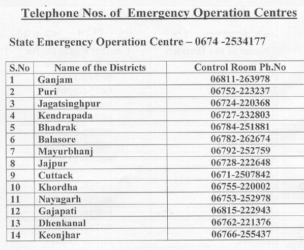
#Phailin - Circulate these emergency numbers for #Odisha...  http://t.co/HzsNbxEdyy

#Phailin - Analysis at 7:30pm indicates, Pressure around 931mb and winds gusting up to 235 kmph... Category 4 storm. 
Nearing Andhra and Odisha coast.
Satellite IR at 7:30pm shows the Core and Eye continue to be WELL formed. Drizzles, moderate rain has started to push into Odisha.

The real time watch at Gopalpur

INCOIS is providing [near] real time observation on sea wave height and its direction.  The latest as available is given below.
Realtime wave height at Gopalpur

Real time wave direction at Gopalpur

Cyclone Phailin - update at 1:30pm

2.30 pm First cyclonic winds felt on the coast and in the state capital, Bhubaneswar. 

2.25 pm: Thousands flee to shelter homes stocked with emergency food supplies and medicines. 

2 pm: National Disaster Response Force (NDRF) teams reach Bhubaneswar. Evacuations begin in Odisha and north Andhra Pradesh.


Above News bits taken from http://zeenews.india.com/news/nation/cyclone-phailin-live-odisha-fears-a-repeat-of-1999_882538.html

1:30pm, Latest analysis of Cyclone Phailin shows "weakening" - Pressure is around 941mb and Wind speeds up to 220 kmph.

Phailin making news !

RT @IndiaToday: 64000 people to be evacuated from 3 coastal districts-Srikakulam, Vizag & Vizianagaram as cyclone #Phailin approaches AP. 

Cyclone Phailin Live: Odisha fears a repeat of 1999 supercyclone ... http://ow.ly/pIfIq 

Srikakulam gears up to face cyclone Phailin ... http://ow.ly/pIfPf 

Andhra govt back in business, all eyes on cyclone Phailin... http://ow.ly/pIfSj 

Cyclone Phailin nears Andhra Pradesh, Odisha; IAF choppers on standby in West Bengal for help at short notice.. http://ow.ly/pIgEB 
#Chennai - 12:50pm, Clear hazy skies with almost NO cloud formations. Warm at 33 C (feels like 36 C).

#kolkata - 12:50pm, #HOT at 34 C (feels like 42 C). Clear skies. This will change in 12hrs as the Nothern outer bands of Phailin moves in.

Category 4, Cyclone Phailin at 11:30am - Outer bands nearing Indian mainland

The Cyclone is now a category 4 storm, and still tracking W-N-W towards Odisha coast.
ADT analysis at 11am suggests, 
     Pressure at around 927mb
     Winds gusting upto 250 kmph
     There's a slight weakening trend seen in ADT analysis.
According to JTWC warning, "MAXIMUM SIGNIFICANT WAVE HEIGHT AT 5:30am IS 52 FEET"
Massive Sea Swells expected ALL along N-W,N,central,N Bay and dangerous along Odisha coast, N-E Andhra coast during next 36hrs.

Latest models show that the system will continue it's W-N-W track and make landfall between Srikakulam in Andhra and Puri in Odisha.
Landfall is expected to be after noon of 12-Oct and before midnight.

Latest visible satellite shot shows the massive size of the system and it's Eye.

Probable land fall

The wind shear tendency as of now indicates land fall between Rushikulya river mouth , North East of Gopalpur and Chilka lake, south west of Puri. i.e between  [19Deg 21Min 42 Sec N / 85 Deg 04 Min 40 Sec East] and [19 Deg 38 Min 17 Sec North / 85 Deg 20 Min 03 Sec East]

{Thanks to my boss Shri.S.W.PREMKUMAR, retired Meteorologist}
RT @aknarendranath: @weatherofindia Raining in Delhi for the last 45 minutes. (7:06am)

The Bay of Bengal is notorious for deadly tropical cyclones


There is good reason to be concerned when a major tropical cyclone forms in the Bay of Bengal. Twenty-six of the thirty-five deadliest tropical cyclones in world history have been Bay of Bengal storms. During the past two centuries, 42% of Earth's tropical cyclone-associated deaths have occurred in Bangladesh, and 27% have occurred in India (Nicholls et al., 1995.) Phailin is likely to be the strongest tropical cyclone to affect India in fourteen years, since the great 1999 Odisha Cyclone. That terrible storm hit Northeast India in the Indian state of Odisha (formerly called Orissa) near the city of Bhubaneswar, as a Category 4 storm with 155 mph winds on October 29, 1999. The mighty cyclone, which peaked at Category 5 strength with 160 mph winds and a 912 mb central pressure shortly before landfall, drove a storm surge of 26 feet (8 meters) onto the coast. The storm stalled just inland, dumping torrential rains on portions of India already saturated from the landfall of Category 4 Tropical Cyclone 04B just twelve days before. The catastrophe killed 9,658 people and left $2.5 billion in damage (1999 dollars), India's most expensive and fourth deadliest tropical cyclone in the past 100 years. Although Phailin is expected to hit the same province of India that the great 1999 Odisha Cyclone hit, Phailin's landfall location is predicted to fall about 100 miles farther to the south, in a region where the coast is not as low-lying. This should keep the death toll due to storm surge much lower compared to the 1999 Odisha Cyclone, where more than 70% of the deaths occurred due to the storm surge. The latest storm surge forecast from IMD (Figure 2) predicts a peak surge under 3', but this is much too low, considering Phailin's recent round of rapid intensification. Phailin's heavy rains will be capable of causing great destruction, as did the rains from the 1999 Odisha cyclone. More than 2,000 of the deaths from that storm occurred due to fresh water flooding in the town of Padmapur, located more than 150 miles from the coast. 

Courtesy: www.wunderground.com
"PHAILIN " is now at 15.5 Deg North / 89.0 Deg East. i.e 600 km South-SE of Paradip {Odisha} / or 600km East SE of Gopalpur.  This is very severe cyclonic storm [VSCS] The sustained wind speed will be around 200-225kmph. It is expected to cross coast between Gopalpur and Paradip on 12.10.2013 afternoon.
111013 00Z CIMSS

101013 12Z CIMSS

Phailin updates

Cyclone Phailin, 4am, pressure around 924.6mb, winds reaching up to 254 kmph. "Really Massive"
Now it's category 4 !