Thursday, October 30, 2008

Clear & Dry for next 48 hrs

Clear and Dry is the forecast for next 2 days.
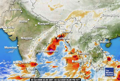
Going by the satellite map, we can see there are formations over the South-east bay... and it seems those formations are moving out of Bay to it's east.

But the numeric forecast says that after 1-Nov-08, we can expect lot of activities over the South-South-west bay. If this happens then we can expect more rain again.

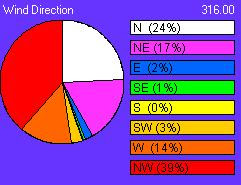
Going by our local obervations, the wind direction is NOT fully OK, it should be from North-East or Pure East to have the Rains get going.
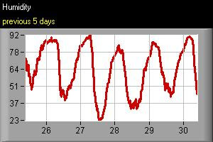
Till now (30-Oct-08, 12:17 PM) after that huge rain on (25-Oct-08) there is no cloud formations. And even the humidity has gone down, making way for a Dry and mild day and slightly chill mornings.
Take a look at the wind direction graph and Humidity graph.


TIP: If you can see a Clear, DARK blue sky then you can say that a NEW weather front is moving in.

Wednesday, October 29, 2008

Recent - Rare - Desert Floods in YEMEN

Flash floods hit north-east India

Tens of thousands of people have been displaced after floods inundated more than 70 villages in the north-eastern Indian state of Assam.

Three districts- Kamrup, North Lakhimpur and Sonitpur - have been affected by the floods.

A senior official said an embankment of the Putimari river was breached late on Tuesday following incessant rains.

Floods in India usually occur during the monsoon season, which generally lasts from June to September.

Flood waters have displaced nearly 70,000 people, damaged crops, and cut off a national highway linking Assam with the rest of the country, officials say.

Paramilitary and local civil defence forces have been called in for rescue operations. Two relief camps have been set up in the Puthimari area.

"It all started overnight and we are trying to shift the people to safer places," Hemkanta Pegu, a civil servant in Lakhimpur district told the Reuters news agency.

Officials say that temporary shelters for the homeless have been set up in schools and government buildings.

They say that many people are camping on highways under plastic sheets with whatever belongings they had managed to salvage from the flood waters.

The regional weather office has warned of more showers in the next 48 hours in the region.

Officials have blamed the latest flooding on the release of excess water from dams by power generating companies in the nearby state of Arunachal Pradesh and in neighbouring Bhutan.

Tuesday, October 28, 2008

2 day Temperature & Percipitation forecast


These are forecasts of accumulated precipitation and temperature extremes for the next two days (0 - 48hrs).

Monday, October 27, 2008

Bright & Clear ....Diwali!!


Nice to see a clear & suuny Diwali morning...

It's now clear that the present weather system has cleared.

And what next??

Going by the latest satellite pic... a huge mass of high moisture cloud mass is seen over most of south bay.

Whether it'll become as a depression? we'll have to wait till this present weather system clears out.

The latest GFS model from "weatherzone.com.au" suggests, this cloud mass will move to the east and dissipate.

"04B - Rashmi" - crashes inland

Take a look at the latest satellite pic and JWTC projection.


This "rashmi" is quiet a fast mover.... just a day back it was recognized as a cyclone and now it's inland.
Here is some extract from http://savethehills.blogspot.com
++++++++++++++++++++++++++++++++++++++++++++++++++++++++
A cyclone called Rashmi is inching towards coastal Bengal, carrying with it the threat of heavy rain in Calcutta though the city does not fall in the storm’s path projected till late this evening.
The Met office said a deep depression over west-central Bay of Bengal, which caused Saturday’s rain, had intensified into a cyclone and was headed for the Bengal-Bangladesh coast near Sagar Island.
Cyclone Rashmi, rated in the low-intensity Category 1 till this evening, is expected to make landfall between 8 and 9.30am on Monday.
“The cyclone now lies about 350km south of Calcutta and is expected to hit the Bengal-Bangladesh coast on Monday morning. The cyclone has been named Rashmi,” said G.C. Debnath, the director of the weather section at the Regional Meteorological Centre in Alipore.
Met officials said gusty winds at speeds between 60 and 80kmph were expected along the Bengal coast, along “with heavy to very heavy rain” on Monday. Officials also warned of heavy rain in Calcutta.
The officials said tonight that the cyclone was proceeding in a north north-eastern direction and was expected to move into Bangladesh soon after hitting land.
“Calcutta is not in the path of the cyclone. But it will cause rains in the city. We are keeping a close watch on the movement of the cyclone,” an official said. But he added that since 350 kilometres lay between the cyclone and land, a shift in course could not be ruled out.
The district magistrates of East Midnapore, South 24-Parganas, North 24-Parganas and West Midnapore have been asked to take precautionary measures, finance minister Asim Dasgupta said.
++++++++++++++++++++++++++++++++++++++++++++++++++++++++++++

Sunday, October 26, 2008

No rain for Diwali...a forecast

Today (26-Oct-08) there is no rain and surely there's not going to be any rains.
And
very importantly there'll not be any rain till Diwali day (27-Oct-08) evening 6 PM.
So people can Enjoy the Diwali without and rain problems.
This 3 day dry spell OR lull in rains will be good for the CRACKER biz..!

" HAPPY DIWALI "

How chennai looks in Rain???


"RAIN BATTERS CHENNAI" from Sulekha.com blog

It is a well known fact that Chennai city is never built with rains in mind because for us monsoon failures are more common than rain battering the city which is a rare occasion. To cap it even if it rains for 24 hours the city will be thrown completely out of gear and jeopardize normal lives. The school children and college students are the worst sufferers in this rain.

This year the ruling party added to the misery of the college students by "obliquely" forcing them to "participate in human chain to express anguish over the sufferings of the Tamilians in Sri Lanka". It was a pathetic site to see those students standing drenched to the bone and most of them feeling terribly embarrassed because the salwar kameez they were wearing was making their contours obvious. The entire human chain drama is purely a political hullabaloo and why the Chief Minister chose to harass the students to stand in the rain continuously for more than five hours which made them shiver is a mystery. (refer Times of India news item timesofindia.indiatimes.com/Cities/Studehttp://timesofindia.indiatimes.com/Cities/Students_suffer__) While Chief Minister Karunanidhi openly criticized his die hard enemy Jayalalithaa as a barren woman ( what a cheap word to use) who cannot understood the problems of children like him who has sired many children (through more than one wife) and is blessed with innumerable grand and great grand children did not seem to "bother about the plight of the students drenched in the rain". He came in his flashy car at 5 P.M in the Evening when the rains had abated to some extent and his political heir M K Stalin came in another car and his "love child" Kanimozhi was not seen anywhere at all - the poor government college students were "forced" to wait till the CM arrived. And he did not arrive well before because he had other plans" to treat all who fell sick free the next day" most probably!!.

Tamil Nadu politics is unique in several ways. One is it continuous unholy alliance with the film industry. Especially in the recent past after Vijayakanth's victory in the Assembly elections every actor mouths stupid sentences on issues of nationally grave implications and it is hugely publicized in all the electronic media. While all other States of India clearly keep politics away from other walks of life ( even Amar singh's hobnobbing with Anil Ambani, Amitabh Bachchan and Jaya Bachchan ended in a fiasco) any Tom Dick and Harry makes political comments and politics after all is the best short cut to cheap popularity and if luck favors the taste of power too.

© girija jinnaa., all rights reserved

First cyclone "04B"

First cyclone of the season "04B" but fortunately or unfortunately it's not for us.
Instead it's heading for Bangladesh.
Take a look at the latest JWTC graph and latest satellite pic (weather.com)

Saturday, October 25, 2008

2 hr Heavy rain


Yesterday (24-oct-08) very heavy electric shower lashed almost all parts of the city
Chennai airport reported 122 MM
Showers lashed for 2 hrs.

Some comments from Accuweather blog

My sights having been turned elsewhere, I missed the exceptional heat over southern Pakistan at Karachi. This heat wave has seen 8 of the last 14 days (as of Thursday) reaching 100 to 102 degrees F/about 38-39 C.

The normal average daily high for October in Karachi is 92 degrees, or about 33 degrees C. October is the heart of a "second summer" in Karachi owing to the onset of offshore winds (related to the North East Monsoon) before lingering summer heat has faded.

About the NE Monsoon, I see that rains have gained ground northward along the east (Andhra) coast. At Nellore, a lull in the rain followed about 10 inches/25 cm since Sunday. To the west, weak tropical low pressure over the Arabian Sea has spurred rainfall of 9.2 inches since Tuesday on Amini, one of the small Lakshadweep Islands.

As of Thursday, that weak tropical low seems less likely to become a tropical depression given the trend in numerical forecasts. More emphatic are forecasts of a tropical depression or tropical cyclone east of India during the early week.

MJO - Madden-Julian Oscillation

A good insight into MJO - by Ahmed, http://kea.metsite.com
For more on MJO click here
-----------------------------------------------------------
Forecasts based on the movement of the periodical Madden-Julian Oscillation (MJO) wave of alternating enhanced and suppressed phases of rainfall suggest that the ongoing wet session over the southern peninsula would weaken towards the month-end. This is based on the assessment that the current phase of the MJO wave, travelling periodically from West Africa into Indian Ocean and further east into the equatorial Pacific and beyond, would be followed up by the suppressed phase from November 1.

This weakened rain phase would last until November 22, according to the ensemble forecast system of the US National Weather Services. The successor MJO phase of enhanced rains is expected to get anchored over equatorial Indian Ocean and the southern Indian peninsula from December 2.

A long-term outlook by the UK Met Office and the European Centre for Medium-Range Weather Forecasts suggested ‘above normal’ rain for southern peninsula through December, January and even early into February.

"I think this happenned last year too. We had a good rain in October, then Nov was very dry and again rains picked up in December"
-----------------------------------------------------------

Thursday, October 23, 2008

Heavy rain and a Break !

For yesterday (22-Oct-08) morning till 10:30 AM it was raining heavy, some times very heavy.
T.Nagar and other parts are partly flooded.
At around 10:40 sun came out bright and it had signs of clearing.
But after 11:30 AM the sky became gloomy and heavy, then it started drizzling heavy and it stopped at around 4:30 PM.
After that drizzle the low level air current changed direction to North-West.
Please note: Once the air-current changes to North-west all the rain activity will reduce to ZERO.

Now (23-Oct-08, 2:15 PM), till now the wind is in North-West-North.
So no sign of Rain yet...!
Look at the latest satellite pic...

we can see two formations, one near "Kerala" and another near "Andhra".
And another likelyhood is VERY near to North-Tamilnadu.
Overall, there was heavy rains thru out Tamilnadu.

Wednesday, October 22, 2008

Some of my Tweets (travel from chennai-pune-chennai)

I'm back in Chennai. oh man, it's raining heavy thru all early morning till now. "chandrayaan" launch successful, lot's of stages ahead. 2 minutes ago from web

moving out of arakonam, lot's of rain thru out. my battery is out. bye bye about 13 hours ago from mobile web

at guntakal, andhra. cloud cover is getting heavy. still no rain sighting yet. hope to get rain in 2 hrs. about 20 hours ago from mobile web

now at raichur, andhra. clear & warm. no sign of rain yet. about 22 hours ago from mobile web

got info from chennai that it was raining heavy thru the night. 7:39 AM yesterday from mobile web

i'm returning to chennai. now in wadi. here clear sky, mild and hazy. 7:38 AM yesterday from mobile web

cold evening in Pune, i'll be leaving pune around midnight by train. 12:14 AM yesterday from mobile web

entering pune. dry & mild & sunny. 9:16 AM Oct 20th from mobile web

good & cold morning in maharastra. dry & cold all the way! it's rainiing in chennai. 9:05 AM Oct 20th from mobile web

at last we have mobile signal. v r near gooty, andhra. clear & dry. 8:06 PM Oct 19th from mobile web

almost no mobile signal. airtel. this is the state indian mobile connectivity 5:49 PM Oct 19th from mobile web

just had lunch. and leaving renigunta. heavy rains after tirutani till renigunda. 5:46 PM Oct 19th from mobile web

just had lunch. and leaving renigunta. heavy rains after tirutani till now. 3:04 PM Oct 19th from mobile web

as we go further into interior, rain & cloud activity is low. 2:51 PM Oct 19th from mobile web

now on my way to mumbai, i might tweet abt the weather on the way! 11:36 AM Oct 19th from mobile web

night was heavy with rain & lightning. i'm tweetin from my htc mobile. 11:34 AM Oct 19th from mobile web

Heavy rain to continue!

We are back after 3 days.
Lot's of heavy rain thru last 3 days.
A low pressure trough near Chennai and south Andhra has caused so much rain so far.
Even lot's of Schools in Tamilnadu were closed yesterday (22-Oct-08).

Here is the latest satellite pic...

It shows more cloud activity over north of Chennai and south Andhra.
And it seems that rain activity might decrease and give a break.
OR
Sometimes after afternoon today (22-Oct-08) The cloud build up over the Bay near North-Tamilnadu might increase.

Friday, October 17, 2008

Chennai weather updates

Follow my Twitter for updated SHORT range weather forecasts.

Follow my twitter

Slow Rain rate!

Now it's official, IMD has declared that North-east monsoon has set in.
After some 3 days of good sharp showers, today it's partly cloudy and sunny at times.
The Rain rate has slowed down after yeasterday (15-Oct-08) night.
The night of 16-Oct-08 received some small showers.

But as i write now (17-Oct-08, 2:36 PM) a huge cloud formation is seen on the east-north-east over the sea.
Here is the latest satellite pic...

some activity can be seen over the south-east Bay.
Soon we will see more and more cloud formations, lowa and Circulations.
Anyway it's a good start to the Monsoon.

Tuesday, October 14, 2008

To support my view on "North-east monsoon"

To support my view on "North-east monsoon" here is a blog from Accuweather.com


*********************************************************************
Monday's satellite imagery of the Indian Ocean region has shown what may be the least cloudy Subcontinent sky since spring or late winter. And cloudiness, such as it is, was over the south, where there have been a few downpours (mostly Tamil Nadu and Kerala).

Withdrawal of the South West Monsoon together with the return of the is the herald the Northeast Monsoon in October, which is what is being seen at this time. In truth, there are not any well-marked northeasterly winds at this time, but rains have begun in the southern east coast. At Chennai, rainfall since late Friday has been 3.1 inches/7.9 cm.

Looking forward over the coming five to seven days one can see the onset of a weak north-south pressure gradient over peninsular India. Coincident with this is the likelihood for further rain over southern India, most notably over Tamil Nadu and southern Andhra Pradesh. In the north, the Westerlies will hold sway with mostly dry weather in answer. A "Western Disturbance"--really a short-wave trough within the Westerlies--will dip into the northern Subcontinent triggering a few thunderstorms mostly along the western Himalaya.

While still in the area of the Indian Ocean, I will make mention of something that could happen late this week. This something would be a tropical depression (even a cyclone) along 10 degrees North latitude west of southern India. As of Monday it is way too early for me to commit to this idea, one way or another. Whatever does happen would most likely drift westward, if Monday's numerical forecasts are true.
*******************************************************************

Monday, October 13, 2008

NE - Started...

The north-east monsoon has started.
The first shower was on 11-Oct-08, at around 7 PM.
The starting rains were bit sluggish and gradually it became vigorous.
There were intermittent sharp showers throughout Sunday, 12-Oct-08.
Some showers were really heavy...
Now (13-Oct-08, Morning) also it's raining intermittently.

Not like last year, the start is really good.
Signs of 2005 north-easter.
Remember: The very same day the monsoon started during 2005.
We'll keep updating the site throughout this North-east.
And watching keenly for the all awaited cyclones..

Saturday, October 11, 2008

From Accuweather

It is, in the subcontinent, the time of transition between SW and NE Monsoons. Surface pressure gradient has gone slack and the Westerlies are making inroads over the north. Monday, hit-or-miss thunderstorms have spread over the southeastern one-half to two-thirds of the subcontinent. There have lately been thunderstorms in and about Mumbai -- another marker of this season of transition.
Looking forward another 5-7 days, I see more of the same: weak surface pressure gradient, variable winds, Westerlies dominating over the north and persistence of an incremental withdrawal of the southwest monsoon. Oh, and no hint of any tropical cyclone.

Signs of North-East

Today we had GOOD signs of North-east monsoon setting in...!
There were lot's of signs for typical early morning North-east showers.
In some places (North of chennai) there were in fact some drizzles and some showers.

Here is one GFS from weatherzone.com

The GFS predicts RAIN and HEAVY after 13-Oct-2008
A Depression may be forming just NORTH of srilanka and it might move inland during early next week.
Here is a prediction from Numeric forecast

sadly the numeric forecast shows nothing for next 48 hrs
Take a look at the latest satellite pic.

and even satellite pic also suggests nothing.
I can assure all that the north-easter current has started and it'll bring showers soon.

Wednesday, October 08, 2008

At the end of SW monsoon - 08

We (Chennai) is at the end of SW monsoon.
Now it's clear skies with patchy clouds around and humid days and mild nights.

Still there is low level SW air current. And no sign of North-easter yet.
Hoping to see the North-East monsoon around 10th to 15th of October.
Usually north-east sets in around 15th in North tamilnadu and around 22nd in south tamilnadu.

This year's north-east will also be a long one, like that of Last year - 2007.

Our next post will be a summary of South-west - 2008.