Wednesday, April 15, 2009

"01B" heading towards Orissa

At present "01B" is mild in strength and heading towards Orissa coast.

Latest satellite shot shows HUGE mass of swirling cloud near Orissa and it's covering almost full of Northern bay.

Here is the warning text and graphic from JTWC

POSITION NEAR 14.9N 86.5E. TROPICAL CYCLONE (TC) 01B LOCATED
APPROXIMATELY 380 NM EAST-NORTHEAST OF CHENNAI, INDIA, HAS TRACKED
NORTHWESTWARD AT 09 KNOTS OVER THE PAST 06 HOURS. RECENT ANIMATED
MULTISPECTRAL IMAGERY AND A 150159Z SSMI/S IMAGE DEPICT AN ORGANIZED
LOW LEVEL CIRCULATION CENTER (LLCC) WITH DEEP CONVECTION TO THE
NORTHWEST WITH BROKEN BANDING WRAPPING INTO THE SOUTHEAST QUADRANT.
TC 01B HAS CONTINUED TO ACCELERATE OVER THE PAST 06 HOURS AS IT
TRACKED TOWARDS THE NORTHWEST. HIGH RESOLUTION QUIKSCAT DATA FROM
142345Z INDICATES THAT THE SYSTEM HAS 35KT WINDS WRAPPING TIGHTLY
AROUND THE LLCC WITH WIND SPEEDS DROPPING QUICKLY AWAY FROM THE
CENTER. THE SYSTEM IS CURRENTLY TRACKING TO THE NORTHWEST UNDER THE
INFLUENCE OF A MID TO LOW-LEVEL RIDGE LOCATED OVER ASIA MINOR. AFTER
TAU 24 THE SYSTEM WILL COME UNDER THE INFLUENCE OF A MID-LEVEL
ANTICYCLONE OVER NORTHERN INDIA THAT WILL HELP TO TRACK THE SYSTEM
TO THE EAST-NORTHEAST. FORECASTED TRACK IS BASED ON GOOD AGREEMENT
OF OBJECTIVE AIDS, WITH EGRR BEING THE ONE OUTLIER TRACKING THE
SYSTEM INTO THE CENTER OF THE ANTICYCLONE OVER NORTHERN INDIA. UPPER
LEVEL ANALYSIS INDICATES THAT THE SYSTEM IS UNDER THE UPPER-LEVEL
RIDGE AXIS AND IN AN AREA OF LOW VERTICAL WIND SHEAR. THE POSITION
IN RELATION TO THE UPPER LEVEL RIDGE AXIS IS PROVIDING GOOD DUAL
CHANNEL OUTFLOW. EQUATORWARD OUTFLOW IS EXPECTED TO REMAIN STRONG,
BUT SUBSIDENCE TO THE NORTH IS STARTING TO HINDER POLEWARD OUTFLOW.
SEA SURFACE TEMPERATURES REMAIN FAVORABLE. BASED ON THE SINGLE
CHANNEL OUTFLOW AND INTERACTION WITH THE UPPER LEVEL SUBSIDENCE OVER
THE NORTHERN PORTION OF THE BAY OF BENGAL, THE FORECAST INTENSIFIES
TC 01B SLIGHTLY SLOWER THAN OBJECTIVE AIDS THROUGH TAU 48. MAXIMUM
SIGNIFICANT WAVE HEIGHT AT 150600Z IS 12 FEET.

"94B" is now "01B"

"94B" is now cyclone "01B", this is the first cyclone of the year 2009.

Here is the latest tracking from JTWC.

TROPICAL CYCLONE (TC) 01B LOCATED APPROXIMATELY 375 NM EAST OF
CHENNAI, INDIA, HAS TRACKED WEST-NORTHWESTWARD AT 06 KNOTS OVER THE
PAST 06 HOURS. RECENT ANIMATED INFRARED IMAGERY AND A 142007Z AMSU-B
PASS INDICATE THAT INCREASED DEEP CONVECTION HAS PERSISTED OVER A
WELL ORGANIZED LOW LEVEL CIRCULATION CENTER (LLCC). TC 01B HAS BEGUN
TO INCREASE TRACK SPEED OVER THE PAST 06 HOURS FROM A QUASI-
STATIONARY POSITION AND IS TRACKING TO THE WEST-NORTHWEST. A MID-
LEVEL RIDGE LOCATED OVER INDIA AND ANOTHER MID-LEVEL RIDGE LOCATED
OVER SOUTHEAST ASIA HAVE CAUSED A WEAK STEERING ENVIRONMENT OVER
THE PAST 24 HOURS, HOWEVER IN THE LAST 06 HOURS THE INCREASE IN
TRACK SPEED SUGGESTS THAT THE RIDGING TO THE WEST OF TC 01B HAS
BECOME MORE OF A DOMINANT INFLUENCE AND WILL HELP TO TRACK THE
SYSTEM TO THE WEST-NORTHWEST AND EVENTUALLY TURNS IT MORE NORTHWARD.
UPPER LEVEL ANALYSIS INDICATES THAT THERE IS SUBSIDENCE ON THE
NORTHERN PERIPHERY OF THE LLCC AND WILL HINDER OUTFLOW IN THE
POLEWARD CHANNEL, LEAVING ONLY THE EQUATORWARD OUTFLOW. BASED ON THE
SINGLE CHANNEL OUTFLOW AND INTERACTION WITH THE UPPER LEVEL
SUBSIDENCE OVER THE NORTHERN PORTION OF THE BAY OF BENGAL, THE
FORECAST INTENSIFIES TC 01B AT A CLIMATOLOGICAL RATE THROUGH TAU 48
WITH ONLY SMALL INCREASES BEYOND TAU 48. SEA SURFACE TEMPERATURES
AND VERTICAL WIND SHEAR ARE FAVORABLE FOR INCREASED DEVELOPMENT
THROUGHOUT THE FORECAST PERIOD. THIS WARNING SUPERSEDES AND CANCELS
REF A, NAVMARFCSTCEN 141121Z APR 09 TROPICAL CYCLONE FORMATION ALERT
(WTIO21 PGTW 141130). MAXIMUM SIGNIFICANT WAVE HEIGHT AT 150000Z IS
12 FEET.

Here is the latest satellite pic from www.weatheronline.co.uk

Here is the latest GFS from BBC , like all GFS models this also shows the same "01B dying out in open seas" before friday (17-Apr-09)

Tuesday, April 14, 2009

"94B" parallel to Chennai

From morning we are tracking "94B"... thru the day, the system gathered moisture and wind. Now (10:20pm,14-Apr-09) it's a potential Cyclone.

Take a look at the latest and some sequence of satellite pics taken from Morning of 14-Apr-09

.

and here is the latest...

Now JTWC is tracking it as "Tropical cyclone formation Alert".

Here is the report and prediction graphic...

FORMATION OF A SIGNIFICANT TROPICAL CYCLONE IS POSSIBLE WITHIN A
225 NM RADIUS OF 12.7N 87.8E WITHIN THE NEXT 12 TO 24 HOURS.
AVAILABLE DATA DOES NOT JUSTIFY ISSUANCE OF NUMBERED TROPICAL
CYCLONE WARNINGS AT THIS TIME. WINDS IN THE AREA ARE ESTIMATED TO
BE 27 TO 32 KNOTS. METSAT IMAGERY AT 140600Z INDICATES THAT A
CIRCULATION CENTER IS LOCATED NEAR 12.7N 87.8E. THE SYSTEM IS
MOVING NORTHWARD AT 03 KNOTS.
2. REMARKS: THE AREA OF CONVECTION PREVIOUSLY LOCATED NEAR 11.8N
87.4E, IS NOW LOCATED NEAR 12.5N 87.8E, APPROXIMATELY 440 NM EAST OF
CHENNAI, INDIA. MULTISPECTRAL IMAGERY DEPICTS A WELL DEFINED LOW
LEVEL CIRCULATION CENTER (LLCC) WITH MULTIPLE DEEP CONVECTIVE BANDS
WRAPPING INTO THE LLCC. A 140010Z AMSU-B PASS INDICATES FRAGMENTED
BANDING WRAPPING INTO THE LLCC WITH THE DEEPEST CONVECTION LOCATED
NEAR THE CENTER AND ON THE SOUTHEASTERN PERIPHERY. A 140001Z
QUIKSCAT PASS SHOWS 20-25KT WINDS WRAPPING AROUND THE EASTERN
PERIPHERY AND INTO THE CENTER OF THE LLCC. UPPER LEVEL ANALYSIS
INDICATES THAT THE LLCC IS LOCATED UNDER AN UPPER-LEVEL RIDGE AXIS
THAT PROVIDS GOOD EQUATORWARD AND POLEWARD OUTFLOW CHANNELS AND LOW
VERTICAL WIND SHEAR. SEA SURFACE TEMPERATURES ARE FAVORABLE FOR
DEVELOPMENT THROUGHOUT THE REGION. INTENSITY ESTIMATES ARE BASED ON
DVORAK ESTIMATES FROM PGTW AND KNES. MAXIMUM SUSTAINED SURFACE WINDS
ARE ESTIMATED AT 27 TO 32 KNOTS. MINIMUM SEA LEVEL PRESSURE IS
ESTIMATED TO BE NEAR 1001 MB. DUE TO INCREASED CONSOLIDATION AND
ORGANIZATION OVER THE LAST 6 HOURS, THE POTENTIAL FOR THE
DEVELOPMENT OF A SIGNIFICANT TROPICAL CYCLONE WITHIN THE NEXT 24
HOURS IS GOOD

Latest GFS models suggests that the "would be cyclone" will move away from Southern Mainland and will eventually die out over the sea.

Take a look at the 72hr prediction till 17-Apr-09.

And GFS also suggests that under it's influence the coastal regions along Andhra and North-Tamilnadu might get showers ... this is due to increase in Total Percipitable water along the coast.

Cyclone potential "94B"

Chennai:

Warm at 34 deg and with 60% humidity.

Now(9:13AM) it's warm and with high cloud cover around.

Looking at the latest satellite pic

"94B" has grown in strength during the past 24 hrs.

FNMOC is tracking it from the begining, 2 days ago.

Here's the report & forecast from JTWC...:

AN AREA OF CONVECTION HAS PERSISTED NEAR 11.8N 87.4E,
APPROXIMATELY 425 NM EAST OF CHENNAI, INDIA. MULTISPECTRAL IMAGERY
INDICATES A BROAD LOW LEVEL CIRCULATION CENTER (LLCC) HAS REMAINED
PERSISTENT OVER THE PAST 24 HOURS WITH FLARING CONVECTION OVER THE
LLCC. A 131335Z SSMIS AND A 131526Z AMSU-B PASS INDICATE WEAK
BANDING TOWARD THE LLCC WITH MOST OF THE DEEPEST CONVECTION LOCATED
ON THE SOUTHERN PERIPHERY. THE LLCC IS ELONGATED ALONG A NORTHEAST
TO SOUTHWEST AXIS, BUT CONTINUES TO CONSOLIDATE. UPPER LEVEL
ANALYSIS INDICATES THAT THE LLCC IS LOCATED SOUTH OF AN UPPER LEVEL
RIDGE AXIS PROVIDING GOOD EQUATORWARD AND POLEWARD OUTFLOW AND LOW
VERTICAL WIND SHEAR. SEA SURFACE TEMPERATURES ARE FAVORABLE FOR
DEVELOPMENT THROUGHOUT THE REGION. MAXIMUM SUSTAINED SURFACE WINDS
ARE ESTIMATED AT 15 TO 20 KNOTS. MINIMUM SEA LEVEL PRESSURE IS
ESTIMATED TO BE NEAR 1003 MB. THE POTENTIAL FOR THE DEVELOPMENT OF A
SIGNIFICANT TROPICAL CYCLONE WITHIN THE NEXT 24 HOURS IS UPGRADED TO
POOR.
JTWC doesn't put it as a threat to land as of now.

The latest 48hrs GFS prediction by FNMOC shows

"94B" will head north into Bay and weaken. And some showers forecast for us after 72hrs.

We'll keep monitoring it, thru the day.

You can follow our tweets for more thru the day

http://twitter.com/rakeshngl

Sunday, April 12, 2009

Yesterday's visible satellite shot

Yesterday's visible satellite shot, shows a lot of activities almost FULL of Tamilnadu and Kerela and over Bay, South Indian Ocean and South Arabian sea.

invi1300.jpg

"92A"..."93B" and now "94B"

on 9-Apr-09 it's "92A"

on 11-Apr-09 it's "93B"

and Now (12-Apr-09) it's "94B"

Previously the formations were around South of India and now "94B" it's over Bay of Bengal.

Going by latest satellite pics we can see lot's and lot's of activities over the South-central bay region and some areas near Norhern Srilanka.

According to FNMOC it's a potential area... but the JTWC is not at all worried.

Even we are also not worried about the situation. Due to this consistent system over Bay, we might get some Thundery out breaks from tomorrow (13-Apr-09).

Yesterday afternoon we saw a huge electric cloud formation over the South-east part of Sea from Chennai.

Chennai: woke up to a 29.6°C (6:04am) morning... high in humidity and Cloudy.

Still the high temperature has not crossed the 35 degree mark, but the air temperature has risen considerably during the past 1 week.

Later in the day, we will see some cloud formations and that will not threaten to rain today.

Take a look at the latest cyclone potential zone map...

Going by the map, we can see why these formations are concentrated to south Seas... and this even shows a slighly cold sea over the present "94B". So this suggests that the "94B" will not be a big threat but with some huge scattered thunder storms.

Friday, April 10, 2009

Chennai during "92A" and "93B"

Chennai:

Yesterday morning it was like a mild monsoon day without rains. Lot's of potential electric clouds were visible around 11 AM and after that nothing materialized.

High temperature was 34.0°C (10:46am).

Today (10-Apr-09) it's mildly humid now (8:52am) as compared to yesterday.

Low temperature 28.8°C (5:47am) is getting high as well... signs of things to come, only good thing is still the air temperature is mild.

Today humidity will be around 65% and there's a remote chance of mild showers late afternoon.

Potential "92A" and now "93B"

Yesterday's (9-Apr-09) potential low pressure system "92A" located just south of southern tip of Indian Mainland has caused more heavy rains thruout southern Tamilnadu and Southern Kerela.

We have reports of very heavy rains over night from Kanyakumari district and from some parts of Southern Kerela.

It seems the system "92A" is no longer valid. And now it's "93B" that too has formed around that same location.

Take a look at the potential "93B"20090410.0230.meteo-7.vis.93B.INVEST.15kts.1010mb.4.4N.82.2E.100pc.jpg

And latest satellite shot shows more rain for the same southern districts of Tamilnadu and Kerela.

inir0100.jpg

Latest GFS predictions show, that the rains will linger around southern districts till end of Monday(13-Apr-09). Moreover the area around southern Indian ocean (3rd and 4th parallel) is going to be very active for next 1 week. The correct area is around south-west of srilanka and direct south of India.

imageserver.png

We'll update the rainfall records later in evening.

Sunday, March 29, 2009

Chaitén Volcano - John Seach

John Seach was the first scientist to climb to the summit of Chaiten volcano after the May 2008 eruption.
John made two expeditions to Chaiten volcano in 2008

Chaitén volcano is located in southern Chile, 10 km NE of the town of Chaitén on the Gulf of Corcovado. The volcano contains an obsidian lava dome in a 3.5 km wide caldera. The volcano is occasionally covered with snow, but does not contain a glacier. Two small lakes occupy the caldera floor on the west and north sides of the lava dome.

chaiten
John Seach climbing to the summit of Chaiten volcano August 2008.
Warning - Climbing Chaiten volcano is currently dangerous and should not be attempted.

chaiten volcano
John Seach at Chaitén town in July 2008

chaiten
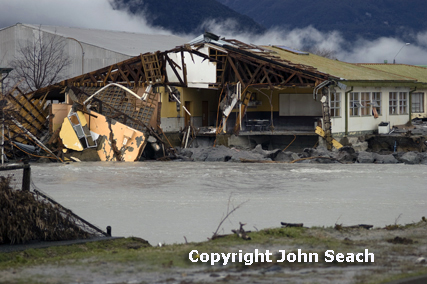
School damaged by lahars in Chaiten town - John Seach

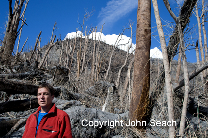
John Seach at Chaiten volcano, 2008.

The volcano erupted on 2nd May 2008. Ash emissions reached a height of 30 km (100,000 ft) on 6th May. More than 4000 people were evacuated fromnearby villages and the town of Chaiten, 10 km from the volcano, and Futaleufu 70 km southeast. This was the first historical eruption at the volcano. The previous dated eruption was over 9000 years ago. The eruption was possibly triggered by tectonic shifts that opened tear faults and promote magma to rise to the surface.

During a visit to Chaitén volcano in Chile on 9th July, John Seach observed lahar destruction of the town, and ashfall damage to surrounding areas, and pyroclastic flow devastation on the north flank of the volcano. On the north side of the volcano at a location 3 km from the crater, an area of devastated forest was visited. Plinian eruptions, and pyroclastic flows, burnt forest and stripped trees of foliage. An area of 10 sq km on the north side of the crater was completely devoid of vegetation, except for some standing devastated trees. Trees up to a meter in diameter were snapped off at a height of 4 m. Fire had burnt the entire area. The field area consisted of a mixture of standing devastated trees, fallen trees, and deep ash deposits. A sharp distinction was observed between areas of devastated forest and standing untouched forest. Continuous ash fall occurred in Chaitén town. Lahars were reaching the town once per week. Residents were allowed into the town to evacuate possessions and begin the clean up. Residents reported hearing rumbling noises under the town, similar to the sound of running water.

In August 2008 John Seach was the first scientist to climb to summit of Chaiten volcano after the May eruption. The summit crater contained a 120 m high lava dome. Earthquakes were felt at the summit. The lava dome was loudly degassing, and lava boulders avalanched from the dome side to the crater floor. John Seach was the first scientist to climb to summit of Chaiten volcano after the worlds largest rhyolite eruption in 100 years.

Taken from www.volcanolive.com

Summer heat on the rise!

Going by satellite images for the past 1 week... it shows a Showery Srilanka and Northern Bay region (Southern West Bengal).

And there was some scattered electric showers around Southern Tamilnadu and along Southern Western Ghats.

No more threat from the Bay for another 1 month.

Only thing is expected, that is PURE Sunshine, Dusty atmosphere and Wind temperature going up.

Chennai:

Still the Wind temperature is bit cool... that's why afternoon's are not that HOT.

Past week's high temperature was around 33 and 34 deg celcius and low was around 25 deg. That's cool compared to that of temperatures this time past month(February).

Max temperature was expected to go beyond 36 deg, but that did not happen.

Humidity was around 65%.

Some towns in southern India is already experiencing 40 deg... this is not good for Summer and if this continues for another month, then we can expect a early south-west monsoon.

Going by the latest GFS... it shows lot of rain activity again along southern most parts of Tamilnadu and along the southern Western ghats. So these regions are expected to get more afternoon electric showers.