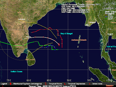
Wow what a speedy intensification the storm has gone through last 6 hours. It took 12 hours for the storm to intensify from T 2.0(30 kts) to T.30 (45 kts). But it took just past 6 hrs to intensify from T 3.0 (45 kts) to T 4.0 (65 kts). Some of the Salient status of the storm are as follows.
Intensity – 4.0
Pressure – 985 mmb
Wind Speed – 65 kts
Location – 11.06 N 87.76 E
Scene Type – EYE/L

can u pls answer my questions as in the older post???....
ReplyDeletecan u pls answer my questions as in the older post???....
ReplyDeleteThanks Pradeep for alert - picture looks like a scan image of a baby!!! Let us await birth with joyous rain for TN/AP.
ReplyDeleteFor all readers
Name "Thane" is synonymous with Mumbai - Navi Mumbai.
Thane is a beautiful vast area nestled among western ghats, dense canopy of forests, torrential rains from june to october - Entire area stretches from east to west.
Prominent places like Vagreshwari[hot springs], beautiful Tansa, Modak, vaitrana lakes, plenty of hill stations. In fact entire land is breathtaking with dense green mountains, creeks, sea. Natures delight
it seems the system is moving northward.
ReplyDeletea category I cyclone in bay and no updates from weatherman!!!!
ReplyDelete...... pls post some more updates pls....INDIANWEATHERMAN
ReplyDeletecan thane become a catagory 2 cyclone before land fall???????
ReplyDeletereasons pls.....
Category 2 is not possible. It will strengthen as Category 1 and before landfall. It will be near Category 1 storm.
ReplyDelete