Jim's Blog in Accuweather.com
***********************************
Return, indeed. There have been indicators hinting of a return to rain over southern India, where rains of the North East Monsoon should be near their height. But a strong anticyclone aloft over the western Subcontinent and the northern Arabian Sea has all but locked out the rain. We have seen scattered rains in the far south as of Saturday.
The strong upper-atmospheric anticyclone will break down during the next three to five days. This alone would be a good thing, but there may be a new twist. Latest GFS scenarios have a tropical cyclone over the Bay of Bengal north of the 15th parallel as of the middle of next week. At latitude lower than 15 degrees North (yes, this would be Tamil Nadu along with southern Andhra Pradesh), such place bodes ill for a widespread rain outbreak
***********************************

Sunday, November 09, 2008
Cyclone forming and a Change in weather is near
Going thru the numeric forecast and latest satellite pic... a change in weather is near. And moreover a depression or cyclone is forming over central Bay, and this too is not going to affect us.
This will trigger the North-east again.


This will trigger the North-east again.


At last there are signs over the Bay
Almost the whole of Tamilnadu is Dry and mild, but still some southern Districts are experiencing rainfalls thru the past week. Especially "Kanyakumari District" had received more rain, almost every day.
Yesterday's rainfall records are here
Tuticorin recorded a very heavy rainfall of 18 Centimetres.
Papanasam (Thanjavur dt), Chittar (Kanyakumari dt), Sathankulam and Tiruchendur (both Tuticorin dt) 2 each and Pechiparai (Kanyakumari dt) 1 each.
In Chennai still no sign of rains, but atleast there are cloud formations from 10 AM to 1 PM, after that clear skies thru to Morning.
Still the humidity is low and the morning chills are here.
Friday, November 07, 2008
Unusually dry at this time of year!
We are experiencing an unusually dry period at this time of year.
It's supposed to be a only rainy season for Chennai.
Forecast :
According to numeric model suggestions...
In coming days the temperature & humidity will go up.
Some signs are here today, partly cloudy and bit warm.
We can expect some showers mid of next week.
Some suggestions are, there'll be a depression formation over the bay during the next weekend.
Some exerts from Accuweather.com Blog.
********************************************
Still virtually no rain on the Subcontinent as of Thursday. Another day of above-normal warmth, too. That is a strong anticyclone (aloft) over the west of the Subcontinent.
Eastward shift and weakening of the upper anticyclone will afford continued above-normal warmth over the Subcontinent into the coming week. It will also allow for the return of scattered rains into Tamil Nadu and Sri Lanka. Not any indication for full-blown NE Monsoon rain as yet. Oh, it will be something to look for next week: a tropical depression or tropical cyclone over the Bay of Bengal.
********************************************
Thursday, November 06, 2008
MJO update
It was abnormally dry, sunny and hot over the Subcontinent again Wednesday. Daytime temperatures 5 degrees F/3 degrees C above normal have been common, yet low humidity and fair sky have favored cool nights.
Key to shaping the unusually settled subcontinent weather has been -- and still is -- a strong anticyclone aloft over the northern Arabia Sea, southern Pakistan and western India. This weather system is forecast to stay strong and dominant through the end of the week, albeit with a slow eastward shift. No meaningful rain through then, to be sure.
A dry phase of the Madden/Julian Oscillation (MJO) is still holding sway over the Indian Ocean basin as of 0000 UTC, Wednesday. A wet phase over East Africa and Arabia is forecast to shift east to the subcontinent as of midmonth. But the latest forecast of the MJO shows a strong dry phase quickly overtaking and overwhelming the wet one.
I, myself, have anything meaningful to add to this MJO forecast. However, I will once again weigh in with a eye toward a return of NE monsoon rains. As of 1200 UTC Wednesday, the GFS is still moistening SE India suggesting a return to showers on or after the 15th. I do believe there will be more rain here before winter's drought sets in, but I do have any good idea of my own as to timing and amount.
Wednesday, November 05, 2008
Weather Has Little Effect on Mood
Some psychological questions appear so obvious they are barely worth asking. Take the link between the weather and average mood. Surely sunshine and blue skies lift the spirits while black clouds and torrential rain send them plummeting?
Jaap Denissen from Humoboldt University and colleagues took a cue from previous research that suggested the answer might not be so intuitive. The results of their study, published recently in the journal Emotion (Denissen et al., 2008), come to the rather surprising conclusion that there is only a very small effect of weather on mood - and this is backed up by two previous studies.
How are you feeling today?
To examine the link Denissen and colleagues collected data over the internet from 1,233 participants across Germany. For one month between July 2005 and February 2007 all the participants completed daily questionnaires. This asked them about both their positive and negative emotions on that particular day. These reports were then compared with data from the German Weather Institute, which was combined to create weather variables: average temperature, wind power and number of hours sunlight.
Once all this data was collated the rather surprising results emerged. On average the weather had no effect on people's positive moods. In other words more sunlight, less wind or a higher average temperature didn't make people feel happier.
On the other hand the study did find that the weather affected people's negative moods. For example, less sunlight was associated with greater tiredness. But, while the weather may have the potential to make us feel worse, the effects measured in this study were tiny: almost too tiny to be noticed. It seems low temperatures, wind and rain may bring us down a little but not as much as we might have thought.
And this study isn't the first to reach similar conclusions about the connection between weather and mood. Two previous studies, one by Watson (2000) and another by Keller et al. (2005), found surprisingly small or sometimes non-existent effects of weather on mood. And for those of you thinking that it might be the German participants who are unusual, these other studies were carried out on Americans.
Seasonal Affective Disorder
So how come many of us are convinced the weather affects mood? Denissen et al. (2008) suggest that we may be responding to a culturally transmitted idea that weather affects mood. Effectively we think the weather has significant effects on our mood because everyone else thinks and says it does.
We may also pay a disproportionate amount of attention to a very small number of people who really do have what has become known as Seasonal Affective Disorder (SAD). These people report that their moods are very strongly associated with the weather. While it might be assumed that this connection is the same for everyone: winter = sad, summer = happy, the data collected by Denissen et al. (2008) doesn't support this. Instead it suggests there are just as many people with SAD who become sadder in the summer and cheer up in the winter. But for the vast majority of us there is no effect.
Time outside
One of the things the study didn't measure, though, is the amount of time participants spent outside. Perhaps the reason for finding little effect was that people in industrialised countries aren't that exposed to the weather - some estimates suggest we spend 93% of our lives indoors.
Previous research by Keller et al. (2005), however, did control for this variable and found that then good weather did increase positive moods. Still, the effect of the weather remained small, and limited to springtime.
Whatever the reason, winter shouldn't be as depressing as we might imagine. Just keep telling yourself that as the wind howls, the evenings draw in and the rain batters against the windows!
Taken from www.spring.org.uk
Monday, November 03, 2008
More on MJO...
More on MJO and it seems it still holds the rains away from South-Asia.
Here is an abstract abt MJO from accuweather.com blog..
++++++++++++++++++++++++++++++++++++++++++++++++++++++++++++++++++++++++++++++

The top panel shows the analysis (as of 0000 UTC Oct. 28). The green marks the "wet phase" and is centered over SE Asia and the "Island Continent" (the area of Indonesia). Dry phase is mostly over the Americas but is building over Africa, too.
Forecast is for a reversal within about two weeks, which would put the dry phase squarely over SE Asia through Australia. Shortly thereafter, the wet phase is forecast to return to the Indian Ocean.
What does all of this mean? Well, given what little I know about the MJO, it looks to me as though the broad-scale upward motion (tropical and sub-tropical) promoting wet weather over the western North Pacific is set to yield to broad-scale sinking and drying during the first half of November. And the dry weather that has set in over the Indian Subcontinent may hold until the latter half of the month. In the Americas, maybe the stubborn drought and heat over much of Brasil will break and the yearly summer rain at last get in fully under way (early to mid-November).
++++++++++++++++++++++++++++++++++++++++++++++++++++++++++++++++++++++++++++++
Thursday, October 30, 2008
Clear & Dry for next 48 hrs
Clear and Dry is the forecast for next 2 days.
Going by the satellite map, we can see there are formations over the South-east bay... and it seems those formations are moving out of Bay to it's east.

But the numeric forecast says that after 1-Nov-08, we can expect lot of activities over the South-South-west bay. If this happens then we can expect more rain again.

Going by our local obervations, the wind direction is NOT fully OK, it should be from North-East or Pure East to have the Rains get going.
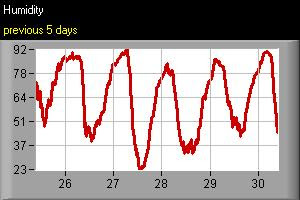
Till now (30-Oct-08, 12:17 PM) after that huge rain on (25-Oct-08) there is no cloud formations. And even the humidity has gone down, making way for a Dry and mild day and slightly chill mornings.
Take a look at the wind direction graph and Humidity graph.

TIP: If you can see a Clear, DARK blue sky then you can say that a NEW weather front is moving in.
Going by the satellite map, we can see there are formations over the South-east bay... and it seems those formations are moving out of Bay to it's east.

But the numeric forecast says that after 1-Nov-08, we can expect lot of activities over the South-South-west bay. If this happens then we can expect more rain again.

Going by our local obervations, the wind direction is NOT fully OK, it should be from North-East or Pure East to have the Rains get going.
Till now (30-Oct-08, 12:17 PM) after that huge rain on (25-Oct-08) there is no cloud formations. And even the humidity has gone down, making way for a Dry and mild day and slightly chill mornings.
Take a look at the wind direction graph and Humidity graph.


TIP: If you can see a Clear, DARK blue sky then you can say that a NEW weather front is moving in.
Wednesday, October 29, 2008
Flash floods hit north-east India
Tens of thousands of people have been displaced after floods inundated more than 70 villages in the north-eastern Indian state of Assam.
Three districts- Kamrup, North Lakhimpur and Sonitpur - have been affected by the floods.
A senior official said an embankment of the Putimari river was breached late on Tuesday following incessant rains.
Floods in India usually occur during the monsoon season, which generally lasts from June to September.
Flood waters have displaced nearly 70,000 people, damaged crops, and cut off a national highway linking Assam with the rest of the country, officials say.
Paramilitary and local civil defence forces have been called in for rescue operations. Two relief camps have been set up in the Puthimari area.
"It all started overnight and we are trying to shift the people to safer places," Hemkanta Pegu, a civil servant in Lakhimpur district told the Reuters news agency.
Officials say that temporary shelters for the homeless have been set up in schools and government buildings.
They say that many people are camping on highways under plastic sheets with whatever belongings they had managed to salvage from the flood waters.
The regional weather office has warned of more showers in the next 48 hours in the region.
Officials have blamed the latest flooding on the release of excess water from dams by power generating companies in the nearby state of Arunachal Pradesh and in neighbouring Bhutan.
Subscribe to:
Comments (Atom)