Maybe it is not where one might have thought as of Monday: however, there may be a tropical cyclone gathering south of the Equator. The JTWC have advised that such may happen over open seas southwest of Sumatra. There is another "whirl" opposite the Equator from southern India and Sri Lanka. It is not as near to tropical depression status as the tropical low to its east.
As for any "ghost" of Tropical Storm Noul, now dissipated over southern Thailand, I see no indication, based upon numerical forecast scenarios, of its regeneration into a tropical depression (let alone tropical cyclone) westward over the Andaman Sea and southern Bay of Bengal.
Tropical moisture wafted over the southern half of India has fostered a few widely-separated thunderstorms on Tuesday. This moisture will bring hit-or-miss thunderstorms over southern and eastern India for another two days or so, bolstered in part by a "Western Disturbance" sweeping eastward over Pakistan and northern India within a well-marked sub-tropical jet stream.
At the weekend and the start of next week, showers and thunderstorms having the "earmarks" of the North East Monsoon are indicated once again by the latest GFS scenarios.

Wednesday, November 19, 2008
Small shower and what more...
Yesterday (18-Nov-08) evening around 5:45PM we had a sharp shower. In some places of Chennai (South-south-east) had experienced even electric shower.
After that the night was mild with moist winds from east-north-east.
Going by latest satellite pic...

A good cloud formation can be seen over North srilanka sea.
This might evolve into a LOW pressure trough along the north-tamilnadu coast.
And it'll prevail there for another 3 days.
This will bring us more rains in coming 48 hrs.
More rains over south-south-tamilnadu..and scattered rain over north tamilnadu.
Thriuvanathapuram 5, Kavali 4, Tirukoilur (Villupuram dt) and Kuzithurai (Kanyakumari dt) 3 each, Ambur (Vellore dt).
After that the night was mild with moist winds from east-north-east.
Going by latest satellite pic...

A good cloud formation can be seen over North srilanka sea.
This might evolve into a LOW pressure trough along the north-tamilnadu coast.
And it'll prevail there for another 3 days.
This will bring us more rains in coming 48 hrs.
More rains over south-south-tamilnadu..and scattered rain over north tamilnadu.
Thriuvanathapuram 5, Kavali 4, Tirukoilur (Villupuram dt) and Kuzithurai (Kanyakumari dt) 3 each, Ambur (Vellore dt).
Tuesday, November 18, 2008
Great morning
Great warm, humid and bright morning.
Deep blue skies. It means we can expect a NEW weather front to move in OR the OLD weather front has cleared.
Mostly Deep blue skies mean more rain on the way..!!
Good eastern air current.
Lot's of heavy cloud movement from east.
Lot's of Electric cloud formation can be seen over the Sea to the east. This means there's something out there.
We can expect the showers to break out after today evening.
South-south tamilnadu (kanyamumari district) is still experiencing Afternoon rains almost daily.
Update regarding the Depression "Noul" over vietnam..:
The system has almost dissipated completely.
JTWC has also given up tracking the system.

Going by the latest satellite pic..
We can see lots of activities over the MARKED area on the satellite image. We'll keep an eye on that area.

Deep blue skies. It means we can expect a NEW weather front to move in OR the OLD weather front has cleared.
Mostly Deep blue skies mean more rain on the way..!!
Good eastern air current.
Lot's of heavy cloud movement from east.
Lot's of Electric cloud formation can be seen over the Sea to the east. This means there's something out there.
We can expect the showers to break out after today evening.
South-south tamilnadu (kanyamumari district) is still experiencing Afternoon rains almost daily.
Update regarding the Depression "Noul" over vietnam..:
The system has almost dissipated completely.
JTWC has also given up tracking the system.

Going by the latest satellite pic..
We can see lots of activities over the MARKED area on the satellite image. We'll keep an eye on that area.

Sunday, November 16, 2008
SUGGESTION
Thanks for all the visits & comments.
In fact each comment by itself is an article in nature.
One suggestion from me:
Shall WE start a common HOSTED website (blog kind) for "India weather, climate, environment...".
In that WE can allow each APPROVED & REGISTERED members to post articles.
If YOU are interested in joining ME with this venture pls mail me at
freedownloadshop@gmail.com
In fact each comment by itself is an article in nature.
One suggestion from me:
Shall WE start a common HOSTED website (blog kind) for "India weather, climate, environment...".
In that WE can allow each APPROVED & REGISTERED members to post articles.
If YOU are interested in joining ME with this venture pls mail me at
freedownloadshop@gmail.com
Regional IMD weather report
Checkout latest IMD regional weather report ...
http://education.vsnl.com/imdchennai/rdwr.htm
http://education.vsnl.com/imdchennai/rdwr.htm
Another depression soon...
According to latest JWTC tracking of another depression near Vietnam.
See for urself...

See for urself...

"05B - Khai-muk" - Final

WE(Chennai) missed the Minor-cyclone's action.
It moved thru South-Andhra and it was quiet a big cloud mass yesterday evening.
Even we were in its southern band.
That's why we got a typical depression style rainfall yesterday(15-Nov-08, 5PM) evening(starting with mild drizzle & then slightly heavy).
The heavy drizzle continued till 3 AM in the morning.

Now the depression is dissipating fast.
And it's remnence can be seen over interior-karnataka.
We received around 15.2 mm of rain.
Today (16-Nov-08,12:49PM) it's clear and with patchy clouds around.
Humidity is little bit high.
For next 48 hrs we can expect clear skies with some passing showers after Today.
Friday, November 14, 2008
Latest on "05B" - No name yet
According to me it's moving north and slightly weak at this stage...
IMD's story:
********************************************
A depression over southeast and adjoining south west Bay of Bengal and lay centred at 1730 hours IST of yesterday, the 13th November 2008 near lat.11.5° N and long. 85.5° E, about 600 kms east-southeast of Chennai. It then moved northwestwards, intensified into a deep depression and lay centred at 0830 hours IST of today, the 14th November 2008, near lat. 12.5 N and Long. 85.0 E about 520 km east-southeast of Chennai and 600 km southeast of Machlipatanam. The system is likely to intensify into a cyclonic storm and move in a northwesterly direction towards coastal Andhra Pradesh. Under its influence, rainfall at most places with isolated heavy to very heavy falls is likely over coastal Andhra Pradesh and adjoining areas of Tamil Nadu during next 48 hours commencing from today, the 14th November 2008 afternoon.
********************************************
Latest JWTC projection and satellite pic...
********************************************


********************************************
IMD's story:
********************************************
A depression over southeast and adjoining south west Bay of Bengal and lay centred at 1730 hours IST of yesterday, the 13th November 2008 near lat.11.5° N and long. 85.5° E, about 600 kms east-southeast of Chennai. It then moved northwestwards, intensified into a deep depression and lay centred at 0830 hours IST of today, the 14th November 2008, near lat. 12.5 N and Long. 85.0 E about 520 km east-southeast of Chennai and 600 km southeast of Machlipatanam. The system is likely to intensify into a cyclonic storm and move in a northwesterly direction towards coastal Andhra Pradesh. Under its influence, rainfall at most places with isolated heavy to very heavy falls is likely over coastal Andhra Pradesh and adjoining areas of Tamil Nadu during next 48 hours commencing from today, the 14th November 2008 afternoon.
********************************************
Latest JWTC projection and satellite pic...
********************************************


********************************************
REQUEST
If anyone reading/following this blog from South-Andhra or Chennai.
Please try to take "SNAPS" or "VIDEO" of the impact of CYCLONE and post it in FLICKR or YOUTUBE or Mail it to "freedownloadshop@gmail.com"
Dont' forget to send us the LINK, we'll publish it here.!
Thanks
ADMIN
Please try to take "SNAPS" or "VIDEO" of the impact of CYCLONE and post it in FLICKR or YOUTUBE or Mail it to "freedownloadshop@gmail.com"
Dont' forget to send us the LINK, we'll publish it here.!
Thanks
ADMIN
Cyclone "05B"... now a cyclone
Still it's not Named, Anyway it's "05B".
Look at the latest projection by JWTC...
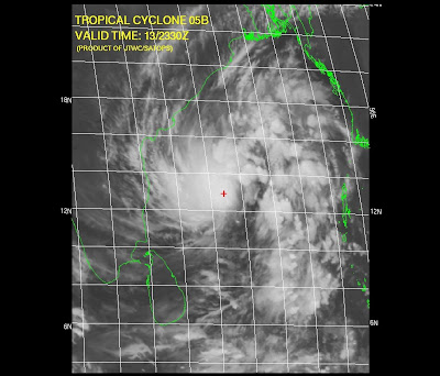

It's destined to HIT South-Andhra. This is happenning after almost 2 years (according to my memory, I'll clarify on this later)
Chennai lies in a least danger zone.
Sky is cloudy and will be cloudy.
Typical sky before a Cyclone.
If the cyclone gathers speed and moves as it is now... then we can expect light showers from Today evening.
Some text from JWTC:
************************************
AT 140000Z TROPICAL STORM (TS) 05B WAS LOCATED NEAR 12.9N
84.8E, APPROXIMATELY 265 NM EAST OF MADRAS, INDIA, AND HAD TRACKED NORTH-
WESTWARD AT 05 KNOTS OVER THE PAST SIX HOURS. MAXIMUM SUSTAINED SURFACE
WINDS WERE ESTIMATED AT 35 KNOTS GUSTING TO 45 KNOTS. SEE REF A (WTIO31
PGTW 140300) FOR FURTHER DETAILS
************************************
Look at the latest projection by JWTC...


It's destined to HIT South-Andhra. This is happenning after almost 2 years (according to my memory, I'll clarify on this later)
Chennai lies in a least danger zone.
Sky is cloudy and will be cloudy.
Typical sky before a Cyclone.
If the cyclone gathers speed and moves as it is now... then we can expect light showers from Today evening.
Some text from JWTC:
************************************
AT 140000Z TROPICAL STORM (TS) 05B WAS LOCATED NEAR 12.9N
84.8E, APPROXIMATELY 265 NM EAST OF MADRAS, INDIA, AND HAD TRACKED NORTH-
WESTWARD AT 05 KNOTS OVER THE PAST SIX HOURS. MAXIMUM SUSTAINED SURFACE
WINDS WERE ESTIMATED AT 35 KNOTS GUSTING TO 45 KNOTS. SEE REF A (WTIO31
PGTW 140300) FOR FURTHER DETAILS
************************************
Subscribe to:
Posts (Atom)