Friday, November 14, 2008

Cyclone "05B"... now a cyclone

Still it's not Named, Anyway it's "05B".
Look at the latest projection by JWTC...


It's destined to HIT South-Andhra. This is happenning after almost 2 years (according to my memory, I'll clarify on this later)

Chennai lies in a least danger zone.
Sky is cloudy and will be cloudy.
Typical sky before a Cyclone.
If the cyclone gathers speed and moves as it is now... then we can expect light showers from Today evening.

Some text from JWTC:
************************************
AT 140000Z TROPICAL STORM (TS) 05B WAS LOCATED NEAR 12.9N
84.8E, APPROXIMATELY 265 NM EAST OF MADRAS, INDIA, AND HAD TRACKED NORTH-
WESTWARD AT 05 KNOTS OVER THE PAST SIX HOURS. MAXIMUM SUSTAINED SURFACE
WINDS WERE ESTIMATED AT 35 KNOTS GUSTING TO 45 KNOTS. SEE REF A (WTIO31
PGTW 140300) FOR FURTHER DETAILS
************************************

Thursday, November 13, 2008

Cyclonic formation "91 B"

Yesteday we did not get any rains till today (13-Nov-08) morning.
Now (12:03 PM) we are experiencing some drizzles & a passing shower.
But good thing is it's heavily cloudy and with good rain bearing clouds forming all over North, north-east and East.
This might be the signs of things to come, because we are tracking a Fairly potential Tropical depression/Cyclone... almost parallel to Chennai.

Here is the latest tracking info from www.nrlmry.navy.mil
********************************************
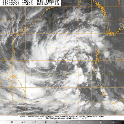
THE AREA OF CONVECTION PREVIOUSLY LOCATED NEAR 10.2N 89.6E
IS NOW LOCATED NEAR 11.8N 87.5E, APPROXIMATELY 430 NM EAST OF MADRAS,
INDIA. RECENT ANIMATED INFRARED SATELLITE IMAGERY SHOWS DEEP CON-
VECTION, THAT WAS PREVIOUSLY CONFINED TO THE THE PERIPHERIES OF THE
CIRCULATION, DEVELOPING NEAR THE CENTER OF THE SLOWLY CONSOLIDATING
LOW LEVEL CIRCULATION CENTER (LLCC). THIS LLCC IS ALSO EVIDENT IN A
121105Z SSMI IMAGE. THIS DISTURBANCE LIES NEAR AN UPPER-LEVEL ANTI-
CYCLONE AXIS, IN AN AREA OF LOW TO MODERATE VERTICAL WIND SHEAR AND
FAVORABLE POLEWARD DIFFLUENCE ALOFT. MAXIMUM SUSTAINED SURFACE WINDS
ARE ESTIMATED AT 20 TO 25 KNOTS. MINIMUM SEA LEVEL PRESSURE IS EST-
IMATED TO BE NEAR 1003 MB. DUE TO THE CONSOLIDATING DEEP CONVECTION,
THE POTENTIAL FOR THE DEVELOPMENT OF A SIGNIFICANT TROPICAL CYCLONE
IN THE NEXT 24 HOURS IS UPGRADED TO FAIR.
********************************************
More abt this from Jim's Accuweather.com Blog...
*********************************************
The broad mass of showers and thunderstorms is loosely organized, but shows good outflow aloft--this is essential to "close the loop" (inflow, rising, condensation and energy release, outflow, sinking) that is exhibited by any tropical storm.
My (learned?) guess is that a tropical cyclone will arise from this mass. Andhra Pradesh and northern Tamil Nadu would be the likely targets for the center of whatever becomes of this entity.
Beyond the question of cyclone/no cyclone, there is the problem of upcoming rainfall (it would be deemed "North East Monsoon" rain) over the south of India (and Sri Lanka). There is going to be some, and there will be locally heavy rain (scattered if no cyclone, focus near landfall if a cyclone).
An aspect of the upcoming rains in southern India has arisen that I had not earlier foreseen. This would be an outbreak of thunderstorms along the west coast and Western Ghats northward to at least greater Mumbai during the first part of next week. A vigorous short wave trough in the Westerlies (Western Disturbance), swinging east from the Khaleej by way of Iran, would play a part in this scenario, were it to happen.
*********************************************

Wednesday, November 12, 2008

Some info from Accuweather - Blog

*******************************************
As the week gets into full swing, it is a good time to pause and assess what is happening, broadly, over the northern Indian Ocean region. The roughly last two weeks have seen exceptionally dry weather, not only where it is usually dry at midfall, but also where it should be raining; namely, the southeast of India.

November is the time of the North East Monsoon, which is really the return of Trade Winds to the Bay of Bengal in answer to the southward shift of the Inter Tropical Convergence. Where northeasterlies blow on shore and up slope (southern east India to Sri Lanka) they bring rain whilst the ITCZ is still significantly north of the Equator. The rains later yield to winter's drought.

So it is an abnormally strong anticyclone aloft, settled as it was over the northern Arabian and the western subcontinent, that shut off the NE Monsoon rains as the four week of October got underway. Only as of this early week are there even a few scattered downpours over southernmost India. But some changes have begun; so, where will this lead?

Satellite imagery shows the scattered deep convection (namely, thunderstorms) has spread westward into the southern half of the Bay of Bengal along with some kind of broad, ill-defined tropical entity. It is this weather system that numerical models have been keying on for something like the last week. However, attempts to spin up a tropical cyclone of it have been no more than numerical fantasy, at least thus far, and the forecast scenarios of the last few days have steered away from any well-marked low (cyclone or depression).

Instead, it looks now like broad, shallow low pressure will tend westward and west- northwestward over the Bay with deep convective rains reaching Sri Lanka as well as Tamil Nadu to southern Andhra Pradesh. Maybe, scattered storms will erupt near the sea northeastward to Orissa.

Were a well-marked low to spin up over the Bay, rather than a broad, shallow and ill-defined low, southern India may end up mostly dry, at least away from the track of the would-be low.
*******************************************

lull.. and what next?


On 10-Nov-2008, there was some rain bursts after a 2 week lull.
Yesterday (11-Nov-2008) again there was lull. In fact there was almost no sign of rain till midnight.
Early morning today (12-Nov-2008, 6 AM) there was some heavy drizzles around.
Now (9:21 AM) it's cloudy, humid, no low cloud movement yet and bad scene is the wind is from west-north-west.
After going thru latest satellite pic and 2 day numeric forecast.
We can say that the RAIN is coming.
It seems to be, there is a LOW formation over the North srilanka.
And this LOW may become into a Depression OR just a Low pressure trough system and move north. If this happens then we'll surely in for more heavy rains in next 36 hrs.

Monday, November 10, 2008

Started again after 2 weeks of lull

Early morning "No chills" and "Clouds moving in from East".
After that around 8:00 AM the sky was deep-blue in color... that itself is an indicator of new weatherfront moving in.
Around 7:30 AM there was some passing drizzles around north-Chennai.
Heavy cloud formations can be seen over the East and above the sea..
At about 1:30 PM the sky broke open..a small sharp shower lasted for 20 min.
Initially the showers will be of light intensity... then it'll get heavier after evening.
There's more rain to come.
Meanwhile we'll keep track on the cloud formations over the Bay near Srilanka.
This might become a Depression in next 24 hrs.

Sunday, November 09, 2008

Some more other blogs

Jim's Blog in Accuweather.com
***********************************
Return, indeed. There have been indicators hinting of a return to rain over southern India, where rains of the North East Monsoon should be near their height. But a strong anticyclone aloft over the western Subcontinent and the northern Arabian Sea has all but locked out the rain. We have seen scattered rains in the far south as of Saturday.
The strong upper-atmospheric anticyclone will break down during the next three to five days. This alone would be a good thing, but there may be a new twist. Latest GFS scenarios have a tropical cyclone over the Bay of Bengal north of the 15th parallel as of the middle of next week. At latitude lower than 15 degrees North (yes, this would be Tamil Nadu along with southern Andhra Pradesh), such place bodes ill for a widespread rain outbreak
***********************************

Cyclone forming and a Change in weather is near

Going thru the numeric forecast and latest satellite pic... a change in weather is near. And moreover a depression or cyclone is forming over central Bay, and this too is not going to affect us.
This will trigger the North-east again.

At last there are signs over the Bay

Almost the whole of Tamilnadu is Dry and mild, but still some southern Districts are experiencing rainfalls thru the past week. Especially "Kanyakumari District" had received more rain, almost every day.
Yesterday's rainfall records are here
Tuticorin recorded a very heavy rainfall of 18 Centimetres.
Papanasam (Thanjavur dt), Chittar (Kanyakumari dt), Sathankulam and Tiruchendur (both Tuticorin dt) 2 each and Pechiparai (Kanyakumari dt) 1 each.
In Chennai still no sign of rains, but atleast there are cloud formations from 10 AM to 1 PM, after that clear skies thru to Morning.
Still the humidity is low and the morning chills are here.

Friday, November 07, 2008

Unusually dry at this time of year!

We are experiencing an unusually dry period at this time of year.
It's supposed to be a only rainy season for Chennai.
Forecast :
According to numeric model suggestions...
In coming days the temperature & humidity will go up.
Some signs are here today, partly cloudy and bit warm.
We can expect some showers mid of next week.
Some suggestions are, there'll be a depression formation over the bay during the next weekend.

Some exerts from Accuweather.com Blog.
********************************************
Still virtually no rain on the Subcontinent as of Thursday. Another day of above-normal warmth, too. That is a strong anticyclone (aloft) over the west of the Subcontinent.
Eastward shift and weakening of the upper anticyclone will afford continued above-normal warmth over the Subcontinent into the coming week. It will also allow for the return of scattered rains into Tamil Nadu and Sri Lanka. Not any indication for full-blown NE Monsoon rain as yet. Oh, it will be something to look for next week: a tropical depression or tropical cyclone over the Bay of Bengal.
********************************************

Thursday, November 06, 2008

MJO update

It was abnormally dry, sunny and hot over the Subcontinent again Wednesday. Daytime temperatures 5 degrees F/3 degrees C above normal have been common, yet low humidity and fair sky have favored cool nights.

Key to shaping the unusually settled subcontinent weather has been -- and still is -- a strong anticyclone aloft over the northern Arabia Sea, southern Pakistan and western India. This weather system is forecast to stay strong and dominant through the end of the week, albeit with a slow eastward shift. No meaningful rain through then, to be sure.

A dry phase of the Madden/Julian Oscillation (MJO) is still holding sway over the Indian Ocean basin as of 0000 UTC, Wednesday. A wet phase over East Africa and Arabia is forecast to shift east to the subcontinent as of midmonth. But the latest forecast of the MJO shows a strong dry phase quickly overtaking and overwhelming the wet one.

I, myself, have anything meaningful to add to this MJO forecast. However, I will once again weigh in with a eye toward a return of NE monsoon rains. As of 1200 UTC Wednesday, the GFS is still moistening SE India suggesting a return to showers on or after the 15th. I do believe there will be more rain here before winter's drought sets in, but I do have any good idea of my own as to timing and amount.