
Wednesday, November 13, 2013
Heavy rain along S Kerala, S tip Tamilnadu
"30W" over S-Central Bay is now a Depression, pressure around 1001mb and has tracked W-N-W... more on this coming up !
Nagercoil (S tip Tamilnadu) got HEAVY rain from 4am to 8am today.
RT @aknarendranath: @weatherofindia Kashmir Valley freezes at sub-zero temp http://t.co/5jDQTgnLO3
RT @ManoramaEnglish: Rain batters Kerala capital, rail traffic disrupted http://t.co/26uDfcOyuL
12pm, Showers continue along S,central Kerala, S tip Tamilnadu ... http://ow.ly/i/3I1oL
RT @rajugana: Bangalore 9.15am, Fog / misty morning, Dry spell continues, Clear skies, Sun is peeping out..rain rain come again...
#Chennai - 1pm, Another DRY day with stiff breeze from N-N-W, N.
Less low cloud formations seen.
Nagercoil (S tip Tamilnadu) got HEAVY rain from 4am to 8am today.
RT @aknarendranath: @weatherofindia Kashmir Valley freezes at sub-zero temp http://t.co/5jDQTgnLO3
RT @ManoramaEnglish: Rain batters Kerala capital, rail traffic disrupted http://t.co/26uDfcOyuL
12pm, Showers continue along S,central Kerala, S tip Tamilnadu ... http://ow.ly/i/3I1oL
RT @rajugana: Bangalore 9.15am, Fog / misty morning, Dry spell continues, Clear skies, Sun is peeping out..rain rain come again...
#Chennai - 1pm, Another DRY day with stiff breeze from N-N-W, N.
Less low cloud formations seen.
Tuesday, November 12, 2013
Rain in Kerala today !!
RT @kiranvijay87: It's raining #kerala #home #pattambi http://t.co/Fifit93COOO (3:56pm)

RT @1stepNorth: enjoying the #rain from inside the car #kerala #downpour http://vine.co/v/hTvOu6eJprU (1:17pm)
RT @1stepNorth: enjoying the #rain from inside the car #kerala #downpour http://vine.co/v/hTvOu6eJprU (1:17pm)
"30W" - drifting W-S-W and NO intensification seen
Latest 3:30pm, satellite visible shows good convective activity over and around the system.

Position as of 11:30am is 10.5 N , 86.8 E
Pressure is still around 1005mb
JTWC warning at 8am IST states that "THE POTENTIAL FOR THE DEVELOPMENT OF A
Latest model(s) suggest a slight intensification into Depression and expects it to move W, W-S-W and make landfall along Central Tamilnadu coast on 15-Nov-2013.


Due to "30W" LOW ... showers expected to start along Tamilnadu coast from 14-Nov, evening.
On 15-Nov, HEAVY and widespread rain expected along central,N coast Tamilnadu, #Chennai and into S Andhra coast.
Showers along Tamilnadu coast is expected to persist after 30W till 18-Nov... http://ow.ly/i/3HoN2
 On 18-Nov, S-S-E Bay is expected to pop another circulation, this can become Cyclone "HELEN"

Position as of 11:30am is 10.5 N , 86.8 E
Pressure is still around 1005mb
JTWC warning at 8am IST states that "THE POTENTIAL FOR THE DEVELOPMENT OF A
SIGNIFICANT TROPICAL CYCLONE WITHIN THE NEXT 24 HOURS REMAINS
MEDIUM."Latest model(s) suggest a slight intensification into Depression and expects it to move W, W-S-W and make landfall along Central Tamilnadu coast on 15-Nov-2013.


Due to "30W" LOW ... showers expected to start along Tamilnadu coast from 14-Nov, evening.
On 15-Nov, HEAVY and widespread rain expected along central,N coast Tamilnadu, #Chennai and into S Andhra coast.
Showers along Tamilnadu coast is expected to persist after 30W till 18-Nov... http://ow.ly/i/3HoN2

Upper level W.D trough seen over N Pakistan, Kashmir ... and the circulation will push into N-W Kashmir in 18hrs .. http://ow.ly/i/3HojM
Due to this W.D, Scattered rain / snow expected over Kashmir and N Himachal during next 24hrs.
Due to this W.D, Scattered rain / snow expected over Kashmir and N Himachal during next 24hrs.
Rain over central Kerala and DRY over rest of #India
RT @rajugana: Bangalore 2.10pm, Sunny n hot, development of clouds in the horizon..after a gap of two weeks.. will it rain today???!!
RT @SalmanPM_: @weatherofindia still raining at #Kochi (2:55pm)
#Chennai - 3:10pm, Another DRY day with some low cloud formations. Temperature is 30.8 °C and pressure is 1008mb ... http://chennai.indianweatherman.com/
3:30pm, Showers seen over central Kerala and coastal Tamilnadu getting cloudy ... http://ow.ly/i/3HnJP
Today, below normal COLD morning for W Rajasthan, Himachal, Kashmir, Punjab and Uttar Pradesh.
Adampur (Punjab) recorded a low of 6.6ºC
RT @SalmanPM_: @weatherofindia still raining at #Kochi (2:55pm)
#Chennai - 3:10pm, Another DRY day with some low cloud formations. Temperature is 30.8 °C and pressure is 1008mb ... http://chennai.indianweatherman.com/
3:30pm, Showers seen over central Kerala and coastal Tamilnadu getting cloudy ... http://ow.ly/i/3HnJP
Today, below normal COLD morning for W Rajasthan, Himachal, Kashmir, Punjab and Uttar Pradesh.
Adampur (Punjab) recorded a low of 6.6ºC
"30W" - moved W-S-W, now a LOW pressure system
During the past 12hrs, the circulation "30W" over S-E central Bay has moved W-S-W.
Now the pressure is around 1005mb.
Location is approximately around 11.4N , 88.4 E... still the system has an elongated low level circulation.

An intensification into a depression is expected on Wednesday, 13-Nov-2013 over S-W central Bay.
Latest GFS expects a landfall as Depression over Central Tamilnadu coast on 15-Nov.


Now the pressure is around 1005mb.
Location is approximately around 11.4N , 88.4 E... still the system has an elongated low level circulation.

An intensification into a depression is expected on Wednesday, 13-Nov-2013 over S-W central Bay.
Latest GFS expects a landfall as Depression over Central Tamilnadu coast on 15-Nov.

Till evening of Wednesday, T showers expected over W-ghats of Kerala, W-ghats, S Tamilnadu.
For coastal Tamilnadu, #Chennai, S coast Andhra, HEAVY rain to start from evening of 14-Nov or morning of 15-Nov.
Latest satellite at 11pm (11-Nov) shows less convective activity seen around the LOW.

Monday, November 11, 2013
Philippines - latest after Super Typhoon Haiyan
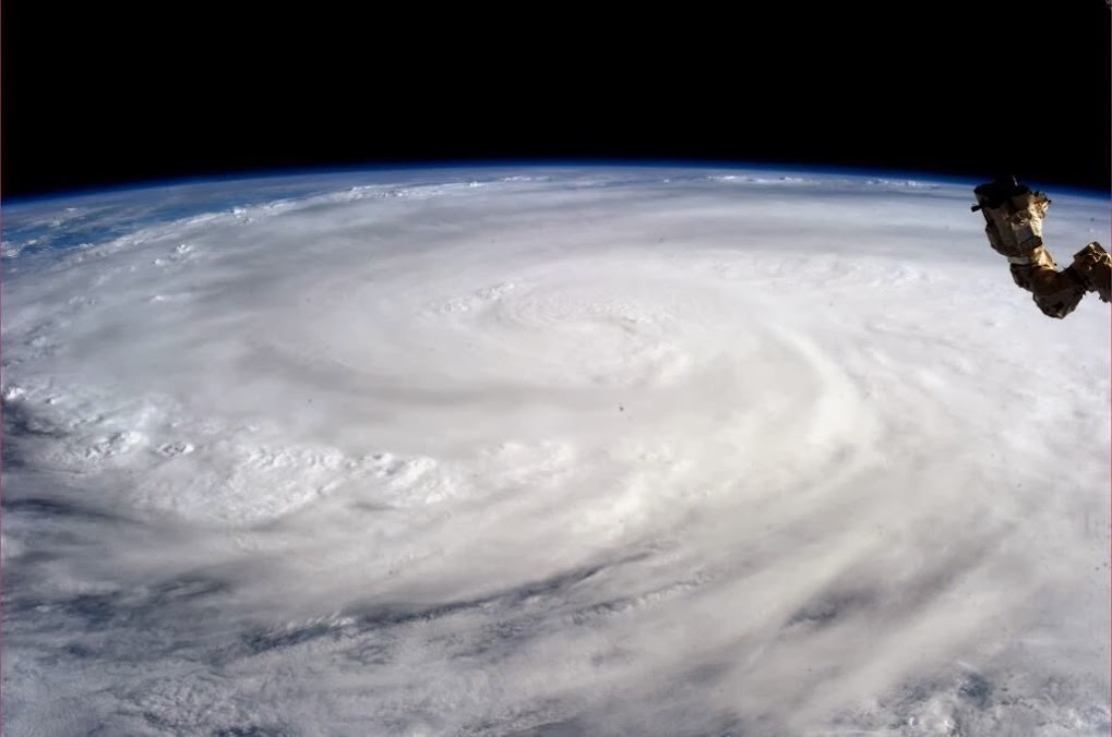
Photo taken by astronaut Karen L. Nyberg, NASA shows Super Typhoon Haiyan from the International Space Station.. http://ow.ly/qHwWp
Typhoon Haiyan devastates Philippines ... photos ... http://ow.ly/qHxK7
Typhoon Haiyan: 'It was like the end of the world' ... http://ow.ly/qHy8i
“The dead are on the streets, they are in their houses, they are under the debris, they are everywhere,” ... http://ow.ly/qHytl
Death toll in Philippines after typhoon Haiyan more than 10,000... http://ow.ly/qHyMv
Typhoon Haiyan devastates Philippines ... photos ... http://ow.ly/qHxK7
Typhoon Haiyan: 'It was like the end of the world' ... http://ow.ly/qHy8i
“The dead are on the streets, they are in their houses, they are under the debris, they are everywhere,” ... http://ow.ly/qHytl
Death toll in Philippines after typhoon Haiyan more than 10,000... http://ow.ly/qHyMv
"30W" over E Bay, what next ?
Early morning, Typhoon Haiyan made landfall over N Vietnam... now its showing rapid dissipation.
------------
"30W" over S-E-Central Bay is showing signs of intensifying.
Still the system is bit elongated from N-N-W to S-S-E.
At present the Northern quadrant of the system is getting good feed from Easterlies.
High winds are concentrated over its North quadrant.

Latest satellite IR at 8:30am shows, good convective activity over N-N-W, S quadrants.
 During next 2 days, the system is expected to become as a marked LOW and move West.

------------
"30W" over S-E-Central Bay is showing signs of intensifying.
Still the system is bit elongated from N-N-W to S-S-E.
At present the Northern quadrant of the system is getting good feed from Easterlies.
High winds are concentrated over its North quadrant.

Latest satellite IR at 8:30am shows, good convective activity over N-N-W, S quadrants.


"03A" makes landfall over N-central coast of Somalia
At around 5:30am, "03A" made landfall over N-central coast of Somalia as Deep Depression.
The pressure at that time was 997mb and Winds was gusting upto 95 kmph.
 Latest satellite shows, HEAVY rain over along coastal Somalia.
And more rain ahead for interior,coastal Somalia and into Ethiopia during next 18hrs.

The system is expected is weaken rapidly and will dissipate in next 18hrs.
The pressure at that time was 997mb and Winds was gusting upto 95 kmph.

And more rain ahead for interior,coastal Somalia and into Ethiopia during next 18hrs.

The system is expected is weaken rapidly and will dissipate in next 18hrs.
Subscribe to:
Posts (Atom)