Monday, September 16, 2013

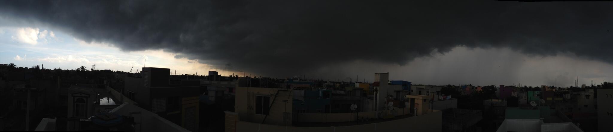
Badlapur, "Cloud burst" - evening of 15-Sep

Badlapur - Cloud Burst, 186.4mm rain till 8.30am today. 100mm was recorded in just 1hr period between 5.30pm to 6.30pm yesterday evening

Badlapur Railway Station view yesterday evening after massive rain in short period. 


Heavy rain for Kerala and W,S central Maharastra for next 2 days

Two circulations seen today, one along Goa coast and another over N Bay just south of Bangladesh ... http://ow.ly/i/3a05z 

2pm, showers seen ALL along from S Maharastra coast to S Kerala... showers popping over  Odisha and N,N-E Andhra.. http://ow.ly/i/3a0fS 

Today, the offshore trough is seen along Goa coast to central Kerala coast ... likely to persist for next 2 / 3 days http://ow.ly/i/3a0mv 

Today a strong upper level 500hpa circulation seen over W,S maharastra... expected to produce more HEAVY rain ... http://ow.ly/i/3a0uu 

During next 36hrs, HEAVY and widespread rain for Kerala, S tip Tamilnadu, Karnataka coast, Goa and S Maharastra coast.
Scattered HEAVY rain also for W,S,central maharastra, N,central,E,S Karnataka, S,W Andhra and into N,N-E Tamilnadu during next 2 days.
Scattered rain to continue over N,N-E Andhra, S Chatisgarh and Odisha during next 3 days.

Sunday, September 15, 2013

Chennai - 11:15pm, a moderate shower system is nearing S, S-W suburbs of city

More rain ahead for W,S,central Maharastra and Kerala.

Upper level W.D trough will drift East, rain over parts of Punjab, Himachal, S Kashmir and even for N-W Uttarpradesh expected till 17-Sep.

An upper level circulation can be seen over N-E Bay along Myanmar coast ... this is expected to persist for 2 days. http://ow.ly/i/39IV7 

Scattered heavy rain over S,central Kerala to continue during next 3 days.
Tomorrow evening, HEAVY rain for S,S-E Karnataka, #Bangalore, S Andhra, N,N-E Tamilnadu and #Chennai.
More rain forecast for W,N-W,S Maharastra on evening of tomorrow as well.
Late evening of Monday can pop heavy rain for S,central,W Andhra. Tomorrow scattered rain also for S Odisha and Chatisgarh.

Tomorrow, N-E Bay circulation is expected to draw a E-W trough from N-E Bay to S Maharastra coast, Karnataka coast http://ow.ly/i/39JiB 

Heavy rain again over W,S,central Maharastra

RT @rajugana: Bangalore 6.00pm, Clear skies, hot and humid day.. Formation of Dark clouds in the evening.. sky pic http://t.co/19IOuzYnfb
RT @iamkanal: Heavy rain at kochi cc  @weatherofindia (10:04am)


RT @senthilvijay: Its raining in north chennai #Tiruvottiyur @weatherofindia http://t.co/04fpuVrWBU (3:49pm)

Davangere - 4:40pm, "raining very steadily and hardly, thundering can be heard" .. http://ow.ly/i/39Ipl 

8:30pm, HEAVY rain over W,central,S,E Maharastra, central,S Andhra, central,E,N Karnataka, S Odisha, N Chatisgarh . http://ow.ly/i/39Ixr 
8:30pm, Showers also seen over central,N Punjab, Himachal and S Kashmir ... http://ow.ly/i/39Ixr

Weather Situation Posted on Sunday (15th) Night:

1. The WD mentioned in Friday's post is moving across the Northern hills and is affecting parts of Northern Punjab (see image as on Sunday evening).
 
Rains and thunder showers are more widespread in Kashmir and part of Punjab plains. Expecting a fall in night temperatures in the hills. Srinagar and other stations will see a fall in night temperatures. Srinagar may witness a night temperature of 10c or below.

2. The trough off the west coast will strengthen next 2 /3 days. By Wednesday 18th, an UAC (or a weak low) can get embedded in the trough off the Goa coast. Since it will not sustain much, can fizzle out in a couple of days after forming.

Chennai - 3:15pm, a heavy T shower now seen over Ponneri zone, north from city and moving east

Saturday, September 14, 2013

More rain ahead for W,central,S Maharastra, #Chennai and #Bangalore before Monday evening

Today, at last the low,mid level circulation near #Chennai has moved N-E and elongated now over W,central Bay... http://ow.ly/i/39jUs 

In 18hrs, a strong low level circulation is expected over S Bangladesh and a weak one along Karnataka coast ... http://ow.ly/i/39jY4 

Tomorrow, circulation expected over S Bangladesh will drop a N-S trough ALL along S-E coast N.Tamilnadu, S.Karnataka and even south of it!

A low,mid level circulation is expected along the N-S trough over N,N-central Andhra on 16-Sep ... http://ow.ly/i/39kzA 
And on 16-Sep, a weak upper level circulation expected over S,S-W,S-central Karnataka ... http://ow.ly/i/39kCf 

From now till 5pm, 15-Sep... moderate, scattered rain for W,S Maharastra, N-W,central,S Karantaka, N,N-E,central,N-W Tamilnadu.
Moderate, scattered rain also for S Andhra and #Chennai before 5pm, Sunday.
HEAVY showers for central,N,N-E Andhra, S Chatisgarh, S,central Kerala and N-E Odisha expected before 5pm of 15-Sep.

From evening of 15-Sep to Monday evening, moderate rain expected for Central,N Karnataka and S Odisha.
Scattered HEAVY rain expected over W,central,N-E Andhra including #Hyderabad from Sunday evening to night of Monday.
5pm, 15-Sep to 11pm, 16-Sep... HEAVY rain for N,N-E Tamilnadu, #Chennai, S Karnataka and #Bangalore.
During next 2 days, T showers to continue over W,central,S Maharastra. And #Monsoon will stay active along central,S Kerala.

Rain in Hosur !

2:17pm, "Heavy down pour in Hosur"

#Bangalore - "In 13 days, over twice the normal rain" ... http://ow.ly/oRCsV 

#Bangalore - 3:10pm, "dark clouds all over...but no rain here."

#Chennai - 3:35pm, Warm with good cloud formation around. Rain is near for parts of city today as well.

#Chennai - 3:30pm, Heavy showers seen W-N-W and over zones around Chengelpet in South.

#Kolkata - 9am, "A TOTAL FREAK THUNDERSTORM HITS KOLKATA !
AGAIN THE RAINS STARTED WITH TINY HAILS "

Now (4:43pm) the temp is around 28 C.

Weather report from around India on 13-Sep-2013

Belgaum - 6:15pm, "very very Heavy Rain now in Belgaum Airport"
"Belgaum Railway station recorded 77 mm of Rainfall on 12-Sep"

Badlapur - 6:55pm, "Severe Thunderstorm lashed Badlapur for 40mins.Torrential rain, huge lightening strikes with loud thunder sound."

6:53pm, "Thunderstorm also lashed Dombivli with continuous Torrential rains , Huge lightening strikes with severe thunder sound.I was not able to sit near windows & watch out the rain as Huge Vertical Lightning was continuously flashing with Burst of Thunder Sounds.And we are getting Heavy rains here for the fifth consecutive days."

BOLLAJE, DAKSHINA KANNADA 6:14pm, "Rain"