Puffy white clouds sailing across a blue sky indicate continuing fair weather. But if they mass together to form tall, anvil-shaped clouds, be prepared for a lightning-filled thunderstorm, even if the sun in shining brightly.
Striped frosty clouds high in the sky indicate the probability of light rain; dark, layered clouds overhead mean steady rain or snow. If you are ever lost at sea, look for the patches of stationary woolly clouds that usually form a little to the windward side of an island.
If your ever out on a clear night and the moon is shining, one way to know that bad weather is coming is to see a ring around the moon, rain or snow depending on the time of year will usually come within 3 days

Sunday, April 06, 2008
Heat is slowly picking up!
In Chennai the heat is slowly picking up, for the past 5 days it was around 33°C.
The humidity is also high, so it's sultry day and mild nights.
Still the wind direction is from South-East and this is favorable for an electric shower.
The southern tamilnadu is experiencing some electric showers then and there.
Still we can see the south BAY is active with upper cyclonic circulation and the Sea temperature is also a bit high.

The humidity is also high, so it's sultry day and mild nights.
Still the wind direction is from South-East and this is favorable for an electric shower.
The southern tamilnadu is experiencing some electric showers then and there.
Still we can see the south BAY is active with upper cyclonic circulation and the Sea temperature is also a bit high.

Tuesday, April 01, 2008

"92B", no threat

As the numeric forecast suggested the "92B" dissipated around the central bay.
Chennai is experiencing the HEAT again for the first time in this Initial Summer burst..
Yesterday's Hi: 35.2°C @ 10:30am Low: 27.2°C @ 6:25am
But at around 1:30 PM there was widespread electric showers...it was heavy at places.
And recorded a 16mm for the day.
Today is April-1 "April Fool's Day"...but this day will mark the start of Summer-2008 for Chennai.
For the past 5 days, the wind direction is again favorable for the moisture from the sea to set in around mid-noon and then later develop into an electric shower.

Another thing, going by the satellite pic we can see the south bay area is still very much active.
I think we can expect a Hot, Humid and Wet APRIL.
Saturday, March 29, 2008
Latest update on "92B"

This is the latest satellite pic... it seems the system has gained strength and moved north. Now it's almost parallel to Chennai and expected movement is north,...presently it's moving north.
Take a look at the latest bulletin from US Navy,
----------------
THE AREA OF CONVECTION PREVIOUSLY LOCATED NEAR 7.3N 89.8E,
IS NOW LOCATED NEAR 8.0N 89.8E, APPROXIMATELY 595 NM EAST OF COLOMBO,
SRI LANKA. RECENT METSAT IMAGERY SHOWS AN AREA OF IMPROVED PERSISTENT
DEEP CONVECTION AND CONTINUED POLEWARD DIFFLUENCE. A PARTIAL 281457Z
ASCAT IMAGE SHOWS A BROAD, BUT BETTER ORGANIZED LOW LEVEL CIRCULATION
CENTER (LLCC) WITH 20 TO 25 KNOT UNFLAGGED WINDS AT THE CENTER AND
WESTERLY FLOW TO THE SOUTH. THE SYSTEM CURRENTLY LIES UNDER AN AREA
OF LOW TO MODERATE SOUTHEASTERLY VERTICAL WIND SHEAR, BUT VERTICAL
SHEAR IS FORECAST TO DECREASE THROUGH THE NEXT 24 HOURS AS THE SYSTEM
TRACKS BENEATH THE SUBTROPICAL RIDGE AXIS. FAVORABLE UPPER LEVEL
DIFFLUENCE CONTINUES TO HELP FUEL THE CONVECTION. DUE TO THE IMPROVED
ORGANIZATION OF THE LLCC, THE POTENTIAL FOR THE DEVELOPMENT OF A
SIGNIFICANT TROPICAL CYCLONE WITHIN THE NEXT 24 HOURS IS UPGRADED
TO FAIR.
Friday, March 28, 2008
Tropical Depression "92B"
We are tracking a tropical low pressure system "92B".
For the past week the southern bay of bengal was very active.
Past week's tropical disturbance was due to the sudden rise is sea temperatures over the south bay. Take a look at the past week and present sea temperature...


Now coming to the tropical low "92B"...first take a look at the satellite pics of last 3 days and now.


This system is quiet a huge one with good moisture feed from the rising sea temperature. The upper cyclonic circulation over the south central bay is still there...this will make the system to sustain.
However some numeric forecasts predict that the system will die down in another 3 days almost near the same location. Anyway keep your fingers crossed till next 48 hrs.
Take a look at the US Navy picture of the sysem.

For the past week the southern bay of bengal was very active.
Past week's tropical disturbance was due to the sudden rise is sea temperatures over the south bay. Take a look at the past week and present sea temperature...


Now coming to the tropical low "92B"...first take a look at the satellite pics of last 3 days and now.


This system is quiet a huge one with good moisture feed from the rising sea temperature. The upper cyclonic circulation over the south central bay is still there...this will make the system to sustain.
However some numeric forecasts predict that the system will die down in another 3 days almost near the same location. Anyway keep your fingers crossed till next 48 hrs.
Take a look at the US Navy picture of the sysem.

Tuesday, March 25, 2008
Unusual Path ...
Here is an illustration of the unusual path traced by the unusual LOW pressure system.


Super March
Most part of March so far was Rainy... rainy!
This phenomenon is quiet unusal.
Let's see what happnd so far? and what's coming up?
Chennai has crossed the Normal rainfall average by a huge amount.
Yesterday Rain - 2.6 mm
24 Hour Rain - 2.6mm
Monthly Rain - 133.8mm (Mar. normal - 3 mm)
Yesterday (24-Mar-08) morning around 10 AM, all of a sudden it rained with lightning and it continued till 1 pm. In some parts of chennai rain was heavy and in others it was slight drizzles only. Most of the heavy rain was around south Chennai.
Today morning and now it's clear with some passing clouds.
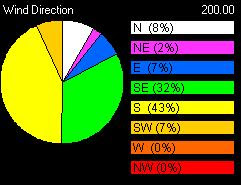
Take a look at the past 5 days wind direction...
Yesterday's satellite pic


Today's satellite pic

This shows a huge mass of cloud formation over the south bay of bengal. The present activity and favorable conditions might make that mass of clouds to become a low pressure system in coming days.
Overall..We are at the end of winter and now starts the dreaded chennai summer.
This phenomenon is quiet unusal.
Let's see what happnd so far? and what's coming up?
Chennai has crossed the Normal rainfall average by a huge amount.
Yesterday Rain - 2.6 mm
24 Hour Rain - 2.6mm
Monthly Rain - 133.8mm (Mar. normal - 3 mm)
Yesterday (24-Mar-08) morning around 10 AM, all of a sudden it rained with lightning and it continued till 1 pm. In some parts of chennai rain was heavy and in others it was slight drizzles only. Most of the heavy rain was around south Chennai.
Today morning and now it's clear with some passing clouds.
Take a look at the past 5 days wind direction...

Yesterday's satellite pic


Today's satellite pic

This shows a huge mass of cloud formation over the south bay of bengal. The present activity and favorable conditions might make that mass of clouds to become a low pressure system in coming days.
Overall..We are at the end of winter and now starts the dreaded chennai summer.
Saturday, March 22, 2008

It's like monsoon here..wow
In chennai rain started after a week on Wednesday... slowly picking up pace and it was raining thru the nite of Thursday into Friday (good friday).
Rain was heavy and with 2 hrs interval... thru the day on Friday.
Here is some rain stats for Chennai.
Yesterday Rain - 59.8 mm
24 Hour Rain - 13.6mm
Monthly Rain - 126.4mm (Mar. normal - 3 mm)
Take a look at the system as of NOW.

These rainy conditions are quiet bizzare and not common in March.
The LOW formed over Gulf of Mannar moved over south extreme of South Tamilnadu and moved into parts of Maldives. This is the position as of Morning, Friday.
This system after gaining strength moved rapidly to the north and laid centered over parts of Lakshadweep.
As i write this blog, the system is still active and carrying a lots of cloud mass around it.
The numeric forecast shows there might be a another system moving in from South Bay.. in next 120 hrs.
So an unusual April ahead....!!!!
Rain was heavy and with 2 hrs interval... thru the day on Friday.
Here is some rain stats for Chennai.
Yesterday Rain - 59.8 mm
24 Hour Rain - 13.6mm
Monthly Rain - 126.4mm (Mar. normal - 3 mm)
Take a look at the system as of NOW.

These rainy conditions are quiet bizzare and not common in March.
The LOW formed over Gulf of Mannar moved over south extreme of South Tamilnadu and moved into parts of Maldives. This is the position as of Morning, Friday.
This system after gaining strength moved rapidly to the north and laid centered over parts of Lakshadweep.
As i write this blog, the system is still active and carrying a lots of cloud mass around it.

The numeric forecast shows there might be a another system moving in from South Bay.. in next 120 hrs.
So an unusual April ahead....!!!!
Subscribe to:
Posts (Atom)