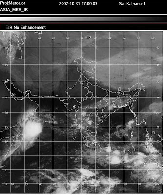
While one might believe that that big, bright (and thus cold and high on this infrared shot) mass marks a strong, growing storm. Not true. By the JTWC, 05A was a minimal tropical storm (highest sustained winds of 35 knots, or 65 kmh) as of 1200 hours, GMT, Wednesday. The low-level center was east of the big, bright cloud mass--a sure marker of strong easterly wind shear. Such shear makes meaningful grow of such storms tough, indeed.
Numerical forecasts are faster in dealing with 05A than had earlier been true. Thus, the low level center is forecast ashore Saturday or Sunday somewhere eastward from Salalah, Oman. The ECMWF, however, seems to dissipate 05A over water rather than steering its ashore. And it seems clear that weakening is shown. For their part, the JTWC weaken and ultimately dissipate 05A over water south of Salalah Friday and Saturday.
So impact upon land (mostly Oman) will hinge upon whether 05A bodily makes landfall (even if no longer a TC) or dissipates off shore. The former would favor heavy falls of rain near the landfall with hit-or-miss thunderstorms inland. The latter would have less impactful rain. Thursday should hold more clues as to whether 05A will make a landfall.
Patterns of down stream moisture owing to 05A suggest at least a day or two of hit-or-miss showers and thunderstorms over Uman, UAE, easternmost KSA and eastern Yemen. First rains would happen Friday in southern Oman.

情色電影, aio交友愛情館, 言情小說, 愛情小說, 色情A片, 情色論壇, 色情影片, 視訊聊天室, 免費視訊聊天, 免費視訊, 視訊美女, 視訊交友, ut聊天室, 視訊聊天, 免費視訊聊天室, a片下載, av片, A漫, av dvd, av成人網, 聊天室, 成人論壇, 本土自拍, 自拍, A片,
ReplyDelete愛情公寓, 情色, 舊情人, 情色貼圖, 情色文學, 情色交友, 色情聊天室, 色情小說, 一葉情貼圖片區, 情色小說, 色情, 色情遊戲, 情色視訊, 情色電影, aio交友愛情館, 色情a片, 一夜情, 辣妹視訊, 視訊聊天室, 免費視訊聊天, 免費視訊, 視訊, 視訊美女, 美女視訊, 視訊交友, 視訊聊天, 免費視訊聊天室, 情人視訊網, 影音視訊聊天室, 視訊交友90739, 成人影片, 成人交友,
免費A片, 本土自拍, AV女優, 美女視訊, 情色交友, 免費AV, 色情網站, 辣妹視訊, 美女交友, 色情影片, 成人影片, 成人網站, A片,H漫, 18成人, 成人圖片, 成人漫畫, 情色網,