Monday, November 11, 2013

Philippines - latest after Super Typhoon Haiyan

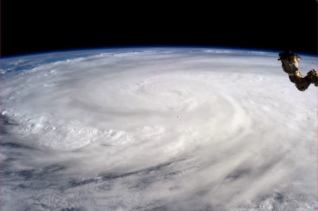
Photo taken by astronaut Karen L. Nyberg, NASA shows Super Typhoon Haiyan from the International Space Station.. http://ow.ly/qHwWp 
Typhoon Haiyan devastates Philippines ... photos ... http://ow.ly/qHxK7 
Typhoon Haiyan: 'It was like the end of the world' ... http://ow.ly/qHy8i 
“The dead are on the streets, they are in their houses, they are under the debris, they are everywhere,” ... http://ow.ly/qHytl 
Death toll in Philippines after typhoon Haiyan more than 10,000... http://ow.ly/qHyMv 

"30W" over E Bay, what next ?

Early morning, Typhoon Haiyan made landfall over N Vietnam... now its showing rapid dissipation.
------------
"30W" over S-E-Central Bay is showing signs of intensifying.
Still the system is bit elongated from N-N-W to S-S-E. 
At present the Northern quadrant of the system is getting good feed from Easterlies.
High winds are concentrated over its North quadrant.

Latest satellite IR at 8:30am shows, good convective activity over N-N-W, S quadrants.
During next 2 days, the system is expected to become as a marked LOW and move West.

"03A" makes landfall over N-central coast of Somalia

At around 5:30am, "03A" made landfall over N-central coast of Somalia as Deep Depression.
The pressure at that time was 997mb and Winds was gusting upto 95 kmph.
Latest satellite shows, HEAVY rain over along coastal Somalia.
And more rain ahead for interior,coastal Somalia and into Ethiopia during next 18hrs.

The system is expected is weaken rapidly and will dissipate in next 18hrs.

Sunday, November 10, 2013

Hopes of Rain from 14-Nov for Tamilnadu coast, #Chennai

Latest analysis show that the circulation over E,S-E Bay is elongated in nature from North to South ... http://ow.ly/i/3GahG 
GFS models predict a W-S-W drift towards S-W Bay during next 3 days ... and may consolidate into a marked LOW .. http://ow.ly/i/3GajL 

Easterlies, Rain are expected to be back for Tamilnadu coast, S coast Andhra from 14 / 15-Nov.
Today analysis show some moisture along #Chennai, N Tamilnadu coast, S coast Andhra.
Scattered rain possible in these zones on today, 11-Nov
And moisture seen over S, W Tamilnadu and over S,central Kerala... Scattered T showers are expected during next 2 days in these zones.

Saturday, November 09, 2013

RSMC New Delhi & Naming of cyclones

The DD over North Indian ocean near 8.0 Deg North / 52.5 Deg East is monitored by RSMC New Delhi.  RSMC New Delhi is responsible for cyclones forming in North Indian ocean just North of Equator to 23.5 Deg North and West of Malacca strait to East African coast i.e 100 Deg East to 40 Deg East.  I do NOT know why this system [DD] is not named?  The cyclone names from Coloumn FIVE has to be drawn.  It should have been named as "HELEN" . But NOT named. Learned Meteorologists may spell the reason.
After land fall of HAIYAN the easterlies poped in the Bay.

The low pressure near Andaman gives rays of hope for wet weather in TN especially for Chennai though NOT immediately but with in next 2-3 days.

Super Typhoon Haiyan - update, 2pm

Typhoon Haiyan, one of the strongest storms ever recorded, strikes Philippines with gusts of up to 200mph (320km/h) http://ow.ly/qEfSO
Typhoon Haiyan leaves 100 dead in Philippines...ow.ly/qEfX6


Where's Typhoon Haiyan now heading ?
Now heading towards central Vietnam coast, with wind speeds upto 180 kmph, pressure at core is around 949 mb.

"90A" is now "03A" - Depression nearing Somalia coast !

Present location of the Depression is over S-W Arabian sea near Somalia coast.
Location ::  7.92 N , 52.20 E
Pressure :: 998 mb
Wind gusts upto 98 kmph

At present the Depression is showing signs of Weakening as it is very close to Land.
Latest satellite IR at 1pm shows, HEAVY convective activity seen only over its N,N-W,W quadrant.
Heavy rain has pushed into N coast of Somalia.

The system may not become as a named Cyclone before landfall.
Models suggest a slight W-S-W movement expected during next 12 hrs and landfall along central Somalia coast by midnight today, 9-Nov-2013.

Friday, November 08, 2013

"90A" - Slowly intensifying and moving West towards Somalia

For S-W Arabian sea depression, 90A, JTWC issues "SIGNIFICANT TROPICAL CYCLONE WITHIN THE NEXT 24 HOURS IS HIGH"
At present the Sea level pressure for "90A" is around 1003mb ... classified as Marked LOW.

But latest Satellite IR at 7:30pm shows that the system has "Intensified" into a Depression ... http://ow.ly/i/3FhRv 

"90A" is moving West and fast towards Somalia coast... expected to make landfall as "Cyclone" on Saturday evening or Sunday.
Another W.D system is expected to reach 12-Nov ... http://ow.ly/i/3FgRx 

Showers may start again for Coastal, S Tamilnadu, #Chennai from 14-Nov ... till then DRY and mild days ahead !
RT @densabraham: @weatherofindia its raining in Tiruvalla, #kerala for 2 hours (7:25pm) . .. http://ow.ly/i/3FgGB