December 1-8,1972
Crossed Tamilnadu coast close to and north of Cudalore at 2330 UTC on 5th December and was within 50 km WNW of Cuddalore at 0300 UTCon December 6. Maximum wind speed recorded at Cuddalore was 111 KMPH to 148 KMPH (60-80) between 2230 UTC of 5th & 0230 UTC of 6th.80 People killed and 30,000 people rendered homeless in Madras due to flood.Total loss Rs. 40 crores.
December 4-11. 1981
Crossed West Bengal Coast near Sagar Island around 1300 UTC on December 10 and weakened into a depression on 11th morning over Bangladesh and into a low the same evening over Assam and Meghalaya.200 people died in 24 Parganas district of West Bengal One Million people affect in the districts of 24 Parganas.
01- 04 Dece. 1993
Crossed on 4th Nov. 30 Km north of Karaikal.100 People died in Tamil Nadu.
28 Nov.-06 Dec1996
crossed near Chennai around 2100 UTC of 6th Dec.1996.The cyclone persisted for 9 days which is reported to be very long life compared to any cyclone in the Indian Ocean. It caused severe damage to life and property.

Friday, December 14, 2007
"92B" inland and now "93B"
The Low pressure system "92B" moves inland and dissipates...
You can take a look at the latest satellite Infrared pic ... this shows clearly how fast the system has dissipated.
Yesterday's heavy rainfall records...
Nagapattinam and Sirkali (Nagapattinam dt) 13 each, Mayiladuthurai (Nagapattinam dt) 12, Vedaranyam, Karaikal, Orathanadu (Thanjavur dt) and Thiruvarur 11 each, Chidambaram (Cuddalore dt) 10, Thiruthuraipoondi (Tiruvarur dt) 9, Parangipettai, Tiruvidaimaruthur (Thanjavur dt) and Muthupet (Tiruvarur dt) 8 each and Cuddalore, Kattumannarkoil (Cuddalore dt), Adiramapattinam, Pattukottai (Thanjavur dt), Valangaiman and Kodavasal (both Tiruvarur dt) 7 each
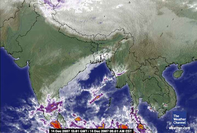
Now the US navy is reporting another tropical disturbance "93B", it's very early stage so no comments now.
You can take a look at the latest satellite Infrared pic ... this shows clearly how fast the system has dissipated.
Yesterday's heavy rainfall records...
Nagapattinam and Sirkali (Nagapattinam dt) 13 each, Mayiladuthurai (Nagapattinam dt) 12, Vedaranyam, Karaikal, Orathanadu (Thanjavur dt) and Thiruvarur 11 each, Chidambaram (Cuddalore dt) 10, Thiruthuraipoondi (Tiruvarur dt) 9, Parangipettai, Tiruvidaimaruthur (Thanjavur dt) and Muthupet (Tiruvarur dt) 8 each and Cuddalore, Kattumannarkoil (Cuddalore dt), Adiramapattinam, Pattukottai (Thanjavur dt), Valangaiman and Kodavasal (both Tiruvarur dt) 7 each

Now the US navy is reporting another tropical disturbance "93B", it's very early stage so no comments now.

"92B" moves inland
Just take a look at the latest satellite pic and make out...

In Chennai, there's just heavy drizzle now(9:36 AM).
There's also reports about drizzles and showers from various part of Tamilnadu.

In Chennai, there's just heavy drizzle now(9:36 AM).
There's also reports about drizzles and showers from various part of Tamilnadu.
Thursday, December 13, 2007
Outer edge of "92B"
Present position of Tropical Depression
13/1430 UTC LAT = 8.8N LONG = 81.4E CATEGORY = T1.5/2.0
Latest bulletin from US Navy
THE AREA OF CONVECTION PREVIOUSLY LOCATED NEAR 7.2N 84.8E,
IS NOW LOCATED NEAR 9.1N 82.4E, APPROXIMATELY 200 NM NORTHEAST OF
COLOMBO, SRI LANKA. RECENT ANIMATED MULTISPECTRAL AND WATER VAPOR
SATELLITE IMAGERY SHOW CONVECTION FLARING ON THE NORTHERN PERIPHERY
OF A WELL-DEFINED LOW LEVEL CIRCULATION CENTER (LLCC) EVIDENT IN A
130348Z ASCAT PASS. THE DISTURBANCE LIES UNDER AN AREA OF FAVORABLE
POLEWARD DIFFLUENCE ALOFT AND MODERATE VERTICAL WIND SHEAR ASSOCIATED
WITH THE PERIPHERAL WINDS OF AN UPPER LEVEL ANTICYCLONE CENTERED WELL
TO THE EAST OVER THE WESTERN NORTH PACIFIC OCEAN. MAXIMUM SUSTAINED
SURFACE WINDS ARE ESTIMATED AT 20 TO 25 KNOTS. MINIMUM SEA LEVEL
PRESSURE IS ESTIMATED TO BE NEAR 1004 MB. THE POTENTIAL FOR THE
DEVELOPMENT OF A SIGNIFICANT TROPICAL CYCLONE WITHIN THE NEXT 24
HOURS REMAINS FAIR.
Take a look at the latest Satellite pic.

Chennai was totally cloudy thru the day.
From evening onwards there was sprinkling of rain, it's continuing now(10:33 PM) also.
The rain rate will increase from early morning.
The above forecast is only IF the present system is sustained and moves east.
According to me the present "92B" depression might break off before tomorrow evening, that too over SEA itself.
13/1430 UTC LAT = 8.8N LONG = 81.4E CATEGORY = T1.5/2.0
Latest bulletin from US Navy
THE AREA OF CONVECTION PREVIOUSLY LOCATED NEAR 7.2N 84.8E,
IS NOW LOCATED NEAR 9.1N 82.4E, APPROXIMATELY 200 NM NORTHEAST OF
COLOMBO, SRI LANKA. RECENT ANIMATED MULTISPECTRAL AND WATER VAPOR
SATELLITE IMAGERY SHOW CONVECTION FLARING ON THE NORTHERN PERIPHERY
OF A WELL-DEFINED LOW LEVEL CIRCULATION CENTER (LLCC) EVIDENT IN A
130348Z ASCAT PASS. THE DISTURBANCE LIES UNDER AN AREA OF FAVORABLE
POLEWARD DIFFLUENCE ALOFT AND MODERATE VERTICAL WIND SHEAR ASSOCIATED
WITH THE PERIPHERAL WINDS OF AN UPPER LEVEL ANTICYCLONE CENTERED WELL
TO THE EAST OVER THE WESTERN NORTH PACIFIC OCEAN. MAXIMUM SUSTAINED
SURFACE WINDS ARE ESTIMATED AT 20 TO 25 KNOTS. MINIMUM SEA LEVEL
PRESSURE IS ESTIMATED TO BE NEAR 1004 MB. THE POTENTIAL FOR THE
DEVELOPMENT OF A SIGNIFICANT TROPICAL CYCLONE WITHIN THE NEXT 24
HOURS REMAINS FAIR.
Take a look at the latest Satellite pic.

Chennai was totally cloudy thru the day.
From evening onwards there was sprinkling of rain, it's continuing now(10:33 PM) also.
The rain rate will increase from early morning.
The above forecast is only IF the present system is sustained and moves east.
According to me the present "92B" depression might break off before tomorrow evening, that too over SEA itself.
"92B" has sustained
TROPICAL DISTURBANCE UPDATE
Bay of Bengal - 2030 GMT
System 92B
Position 7.1N 83.9E
Likelihood of a tropical cyclone forming within 24 hours: FAIR
Here in chennai, morning (8:49 AM).
It's heavily cloudy. This may the outer edge of the depression "92B".
Let's hope this system brings us good rain.
Take a look at the latest numeric forecast for next 24hrs

Bay of Bengal - 2030 GMT
System 92B
Position 7.1N 83.9E
Likelihood of a tropical cyclone forming within 24 hours: FAIR
Here in chennai, morning (8:49 AM).
It's heavily cloudy. This may the outer edge of the depression "92B".
Let's hope this system brings us good rain.
Take a look at the latest numeric forecast for next 24hrs

Wednesday, December 12, 2007
"92B" is moving
Here's the latest report from US navy ...
THE AREA OF CONVECTION PREVIOUSLY LOCATED NEAR 4.9N 85.5E,
IS NOW LOCATED NEAR 7.2N 84.9E, APPROXIMATELY 295 NM EAST OF
COLOMBO, SRI LANKA. RECENT ANIMATED MULTISPECTRAL AND WATER VAPOR
SATELLITE IMAGERY SHOW CONVECTION FLARING ON THE NORTHERN PERIPHERY
OF A WELL-DEFINED LOW LEVEL CIRCULATION CENTER (LLCC) EVIDENT IN A
120409Z ASCAT PASS. THE DISTURBANCE LIES UNDER AN AREA OF FAVORABLE
POLEWARD DIFFLUENCE ALOFT AND MODERATE VERTICAL WIND SHEAR
ASSOCIATED WITH THE PERIPHERAL WINDS OF AN UPPER LEVEL ANTICYCLONE
CENTERED WELL TO THE EAST OVER THE WESTERN NORTH PACIFIC OCEAN.
MAXIMUM SUSTAINED SURFACE WINDS ARE ESTIMATED AT 20 TO 25 KNOTS.
MINIMUM SEA LEVEL PRESSURE IS ESTIMATED TO BE NEAR 1005 MB. THE
POTENTIAL FOR THE DEVELOPMENT OF A SIGNIFICANT TROPICAL CYCLONE
WITHIN THE NEXT 24 HOURS REMAINS FAIR.
Take a look at the latest Satellite pic from F-15 pass over (US Navy)

Infrared from Weather.com

THE AREA OF CONVECTION PREVIOUSLY LOCATED NEAR 4.9N 85.5E,
IS NOW LOCATED NEAR 7.2N 84.9E, APPROXIMATELY 295 NM EAST OF
COLOMBO, SRI LANKA. RECENT ANIMATED MULTISPECTRAL AND WATER VAPOR
SATELLITE IMAGERY SHOW CONVECTION FLARING ON THE NORTHERN PERIPHERY
OF A WELL-DEFINED LOW LEVEL CIRCULATION CENTER (LLCC) EVIDENT IN A
120409Z ASCAT PASS. THE DISTURBANCE LIES UNDER AN AREA OF FAVORABLE
POLEWARD DIFFLUENCE ALOFT AND MODERATE VERTICAL WIND SHEAR
ASSOCIATED WITH THE PERIPHERAL WINDS OF AN UPPER LEVEL ANTICYCLONE
CENTERED WELL TO THE EAST OVER THE WESTERN NORTH PACIFIC OCEAN.
MAXIMUM SUSTAINED SURFACE WINDS ARE ESTIMATED AT 20 TO 25 KNOTS.
MINIMUM SEA LEVEL PRESSURE IS ESTIMATED TO BE NEAR 1005 MB. THE
POTENTIAL FOR THE DEVELOPMENT OF A SIGNIFICANT TROPICAL CYCLONE
WITHIN THE NEXT 24 HOURS REMAINS FAIR.
Take a look at the latest Satellite pic from F-15 pass over (US Navy)

Infrared from Weather.com

Almost a Depression "92B"
Past positions
10-Dec ---> 5.3N 85.4E
11-Dec ---> 5.7N 85.4E
12-Dec ---> 4.5N 85.6E
Category: T1.0/1.5
It has moved...
TROPICAL DISTURBANCE UPDATE
Bay of Bengal - 1800 GMT
System 92B
Position 4.9N 85.5E
Location 355 miles ESE of Colombo, Sri Lanka
Likelihood of a tropical cyclone forming within 24 hours: FAIR
This disturbance has maintained its structure, although atmospheric conditions continue to be less than favourable. Any improvement could give rise to a fully fledged cyclone
Take a look at the latest satellite...

10-Dec ---> 5.3N 85.4E
11-Dec ---> 5.7N 85.4E
12-Dec ---> 4.5N 85.6E
Category: T1.0/1.5
It has moved...
TROPICAL DISTURBANCE UPDATE
Bay of Bengal - 1800 GMT
System 92B
Position 4.9N 85.5E
Location 355 miles ESE of Colombo, Sri Lanka
Likelihood of a tropical cyclone forming within 24 hours: FAIR
This disturbance has maintained its structure, although atmospheric conditions continue to be less than favourable. Any improvement could give rise to a fully fledged cyclone
Take a look at the latest satellite...

Tuesday, December 11, 2007
Latest on "92B"
What's is happening with LOW 92B.
It's just a low pressure system, lying south-east of Srilanka.
I still have lots of IF's and BUT's about the system because it's very slow to develop and move.
Here is the latest satellite imagery...

In Chennai, today morning it was cloudy and almost rain. Though the cloud was not heavy by no means but it was surely shower bearing ones. By mid-noon everything cleared off and it was just hazy towards the evening.
Temperature was Hi: 29.5°C @ 1:31pm
and Humidity was Low: 56% @ 1:37pm... very low indeed at noon.
It's just a low pressure system, lying south-east of Srilanka.
I still have lots of IF's and BUT's about the system because it's very slow to develop and move.
Here is the latest satellite imagery...

In Chennai, today morning it was cloudy and almost rain. Though the cloud was not heavy by no means but it was surely shower bearing ones. By mid-noon everything cleared off and it was just hazy towards the evening.
Temperature was Hi: 29.5°C @ 1:31pm
and Humidity was Low: 56% @ 1:37pm... very low indeed at noon.
Subscribe to:
Posts (Atom)