Wednesday, October 16, 2013

RT @rajugana:  Bangalore 3.30pm, Partly cloudy skies, it rained in the AN; now its dark n appears more rain likely!! http://t.co/Tw3Hnw6hNk 

#Chennai - 4:20pm, cloudy now. Chance of localized shower in next 2 hrs.

Tamilnadu - 4pm, Showers seen near Puducherry zone and over N-central, N Tamilnadu.

Monsoon withdrawal and remnant of Phailin

Long 2013 SW #Monsoon is expected to withdraw from N,N-W,central India during next 3 days.

Today, a strong Anti-cyclone is persisting over S Rajasthan and expected to persist for another 5 days.. this'll speed up the withdrawal !

The remnant of Cyclone Phailin is still persisting over Bihar ... http://ow.ly/i/3rd4E 

Phailin remnant has dumped Heavy rain over E Uttarpradesh, Bihar during past 48hrs.

Phailin dumps rain and misery on UP, Bihar ... http://ow.ly/pREMx 
15 killed, power supply snapped in Bihar ... http://ow.ly/pREOG 
Seven dead as heavy rains lash Bihar ... http://ow.ly/pRERN 

The remnant circulation of Phailin in Low levels is expected to persist even till Saturday !.. http://ow.ly/i/3rdJO 
But the rain over E Uttarpradesh, Jharkhand, Bihar and N,central Bengal has subsided and will be even if the circulation persists.

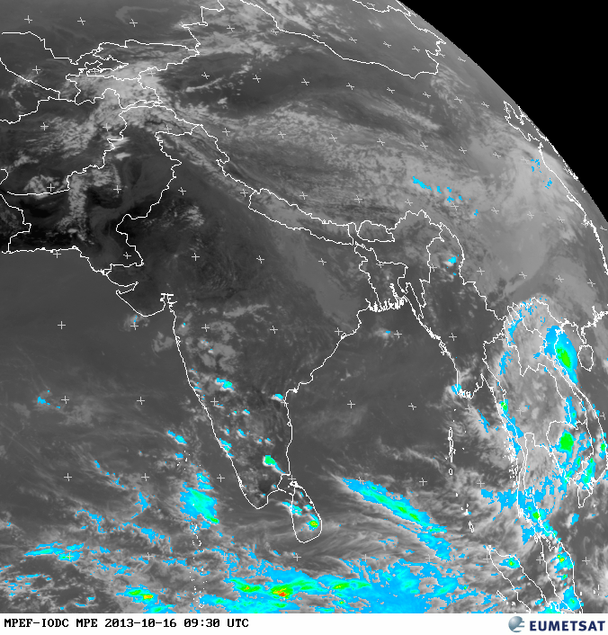
3pm, LESS rain seen over most of India, except over S Peninsula ... http://ow.ly/i/3re3z 

16 Oct 2013 / 0300 UTC latest synop


Chennai/ Minambakkam
13-00N| 080-11E| 10m
03:00
AAXX 16034


43279 22997 10000 10290 20247 30086 40103 80001 333 10338 20255 59009 6003/ 81075=


Bangalore
12-58N| 077-35E| 920m
03:00
AAXX 16034
43295 22497 73202 10230 20200 39100 48510 85630      333 10288 20210 56690 59010 6998/ 83710 83612 86358=


Thiruvananthapuram
08-29N| 076-57E| 60m
03:00
AAXX 16034
43371 22597 13203 10276 20232 30033 40105 81400 333 10330 20232 59011 6990/ 81620=


Hyderabad Airport
17-27N| 078-28E| 530m
03:00
AAXX 16034
43128 32596 50000 10272 20201 39509 40105 82501      333 10319 20223 59003 82620 83070=


Courtsey :ogimet.


www.ogimet.com

RT @rajugana:  Bangalore 2.20pm,15-Oct Rain is back !!! Cloudy sky since morning, and it is drizzling now. sky pic http://t.co/uJ5OupfmgV

Tuesday, October 15, 2013

When NEM setting.

15.10.2013 /15Z upper wind

15.10.2013 / 12Z lower wind
The current upper level winds are predominantly South Easterly which can be reciprocated by North Westerly winds  in lower levels from ground.  [With respect to TN and South peninsula] This indicates that SWM is still in force.
SW [to] Westerly [to] NW [to] Northerly and then to NEly is the reversal pattern. However the reversal sometimes may occur very rapidly. The prolonged SWM may lead to frequent formations of low / depressions / cyclones in the Bay and indirectly help to boost NEM rainfall. 
What ever it may be we are getting rainfall.

Chennai - 6:20pm, sharp showers now over Polichalur zone.
"Upper level winds are from east"

Monday, October 14, 2013

NEM Watch -3

The current ENSO trend, which is neutral and the MJO, which shows  a weak phase till the 21st, and a "neutral phase from the 22nd till end of October. 

A rapid movement of the ITCZ towards the South, we see Easterlies picking up along the TN coast from Wednesday.
NE winds start their domination from Tuesday.
However, it can be assumed, seeing the November MJO and Easterly wave flow, with a couple of strong systems from the Bay, the NEM will be near normal in Chennai (Normal = 822 mms .Expected 800 mms). Overall we see the NEM can be above normal by 10% in TN (All TN average = 440 mms. Expected 500 mms) and about 10% above Normal in Vellor (Normal 414 mms. Expected 450 mms).
Bangalore may get its normal share of 225 mms for the season.
From the current trends, it seems the NEM will set in around the 22nd of October.We can assume the NEM to remain weak to moderate till the end of October. We see the Monsoon strengthening only in November.

On Wednesday, a low form in the Southern parts of the Bay, around the 10N/12N line.
The Low moves westwards, and gets embedded in an Easterly trough East off Sri Lanka along the 10/11N line. But due to lack of favourable parameters, it is apperant the easterly wave lacks strength, and may precipiatate only around Sri Lanka region (East coast)...

Chennai will get brisk East winds from Wednesday as a result.
As a line of wind discontinuity forms in the Southern Peninsula Interiors, we get thunder showers in interior TN and Karnataka from Tuesday thru the week.But, Thunder Showers in Chennai city on Tuesday and Wednesday.
Bangalore gets good thunder showers from Tuesday thru this week, due to the LWD.

from vagaries

Sunday, October 13, 2013

Chennai - 6:07pm, Polichalur zone just had a 10min sharp shower .

Chennai - 5:10pm, 5 min drizzle over Polichalur zone

Phailin is now inland - What next ?

Analysis at 11:30pm shows that the Cyclone has moved inland almost 70% of the core.
Weakening seen, but still it's a category 3 storm, churning it's way into S-W,W Odisha.
Satellite IR at 11pm shows still the Cyclone has not lost its intensity, only the EYE of the system got disappeared.
The landfall was close to Vizagnagaram./ Dharmavaram.
The last (10pm) analysis of intensity when the system's center was over Sea.
      Pressure was around 949mb and winds was up to 200 kmph.

What next ?
~~~~~~~~~
During next 12hrs, Phailin will weaken and will be over S Odisha as a Cyclone.
After that the system is expected to track N-N-W into central,N Chatisgarh as Deep Depression.
By early hrs of Monday, the Depression will further weaken as Depression or well marked Low and move North into N Chatisgarh, E Madhyapradesh and pushing into S-E Uttarpradesh.
By Monday noon, Phailin will become as a low and expected to be over S-E Uttarpradesh.

As the Cyclone travels from S-coast Odisha to S-W,W Odisha and into Chatisgarh and into S-E Uttarpradesh... Heavy rain and winds expected over above mentioned zones from now and before Monday(14-Oct) evening.
Heavy rain expected over S,S-W Bengal, Jharkhand and central,N Chatisgarh before mid-noon of Sunday.
From noon of Sunday, Heavy rain also over E Madhyapradesh and pushing into S,S-E Uttarpradesh.
On Monday, Heavy rain expected over S,S-E,central Uttarpradesh and into W,S,central Bihar.

Tomorrow, Coastal, S Karnataka, N,N-E Tamilnadu and #Chennai also will get moderate showers.